Harshaw, Arizona stands as a historic ghost town 70 miles southeast of Tucson. Founded in 1873 following David Harshaw’s silver discovery, it boomed to 2,000 residents by 1880, producing over $1.1 million in silver annually. The town declined after the 1893 Sherman Act repeal. Today, you’ll find the James Finley House, adobe ruins, and a cemetery with 61 memorials. Beyond the visible remnants lies a complex story of environmental impact and cultural diversity.
Key Takeaways
- Harshaw was a silver mining boomtown founded in 1873 that peaked at 2,000 residents before declining after the 1893 Sherman Act repeal.
- The ghost town is located 70 miles southeast of Tucson in the Patagonia Mountains with mining operations lasting until the 1960s.
- Visitors can explore the James Finley House, adobe foundations, mill remnants, and a cemetery with 61 known memorials.
- Access is primarily via Forest Route 49, but visitors must respect private property boundaries and bring navigation aids.
- Environmental issues persist from mining operations, including acid drainage and heavy metal contamination affecting local watersheds.
The Rise and Fall of a Silver Boom Town
After being ordered off Apache land in 1873, cattleman David Tecumseh Harshaw pivoted to prospecting and discovered rich silver deposits in what would become his namesake town.
By 1879, he’d sold a major claim to Hermosa Mining Company, which built a 20-stamp mill that catalyzed explosive growth.
The town flourished quickly, reaching 2,000 residents by 1880 with the post office opening that same year.
Silver mining brought unprecedented prosperity—the district produced $1.1 million in silver that year, with the Hermosa Mine alone generating $700,000 by 1883.
The staggering wealth beneath Harshaw transformed a prospector’s dream into a silver empire worth millions.
The town was one of several communities named Harshaw across America, with the surname originating from Irish ancestry.
Before mining transformed the landscape, the area was known as “el Durazno” for its fruit orchards that once dotted the region.
Economic shifts eventually doomed Harshaw.
The 1893 repeal of the Sherman Silver Purchase Act devastated silver demand.
Operations became sporadic until ASARCO’s final closure in 1956, leaving behind both toxic waste and displaced families.
Exploring the Mining Legacy of Southern Arizona
Beyond its brief but intense heyday, Harshaw stands as a tribute to southern Arizona’s profound mining heritage that shaped the region’s development for over a century.
Walking these grounds, you’ll trace an impressive legacy of extraction—approximately 1.3 million tons of ore yielded 9.2 million ounces of silver among other minerals. Located approximately 70 miles southeast of Tucson in the Patagonia Mountains, this historic mining district once bustled with activity.
As mining technology evolved, ownership transferred from individual prospectors to corporate giants like ASARCO, who modernized operations with advanced mills and smelters. Despite economic challenges including the Great Depression, community resilience kept mining activities alive intermittently until the 1960s.
This industrial past left environmental scars, with acid mine drainage affecting local watersheds.
Recent remediation efforts by the Forest Service demonstrate our evolving relationship with this complex heritage—balancing appreciation for the wealth and community these mines created with responsibility for their lasting impact.
Daily Life in a 19th Century Mining Community
While silver and copper pulled adventurers to Harshaw, daily life in this 19th century mining community demanded remarkable resilience from its inhabitants.
You’d find a hierarchical social structure where Cornish miners occupied privileged positions while Mexican laborers, recruited from neighboring regions, formed the workforce backbone. Mining camps attracted a diverse range of people including Jewish businessmen, women prospectors, and immigrants from Syria and other nations. As families joined male workers, community activities evolved beyond saloons to include religious gatherings and cultural celebrations that bridged ethnic divisions. Saloons and gambling halls were central gathering places where miners would spend their hard-earned wages after long shifts underground.
- Frame buildings crowded together creating perpetual fire hazards with minimal water access
- Company stores extending credit for furniture and appliances to encourage worker permanence
- Women establishing households in harsh conditions while maintaining cultural traditions
- Labor dynamics creating tension between white miners’ unions and Mexican laborers
- Apache conflicts and highway robberies threatening daily travel and commerce
What Remains: Visiting Harshaw Today
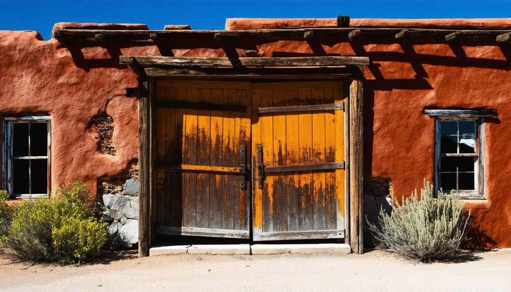
When visiting Harshaw today, you’ll find the James Finley House as the most prominent surviving structure, registered as a historic place since 1974.
You can explore accessible ruins including adobe foundations, mill remnants, and two small cemeteries that serve as poignant reminders of the town’s mining-era residents. An aging cemetery exists on a hill above the Harshaw sign, containing tombstones and crosses marking the graves of former inhabitants. The town once had a thriving population that diminished as mining operations eventually ceased in the area.
Access to the ghost town is primarily via Forest Route 49, though you must respect private property boundaries marked by “No Trespassing” signs, particularly areas owned by Hale Ranch and the ongoing South32 mining operations.
Surviving Historical Structures
Despite once thriving with over 150 buildings during its boom years, Harshaw today offers visitors only sparse remnants of its former glory.
The most notable structure is the brick house with its distinctive pillared porch built by James Finley in 1887, which remains occupied. Most architectural styles visible date from the 1877-1882 boom period, including adobe dwellings and the deteriorating wooden mining supervisor’s home.
- A single fenced-off building stands as the primary accessible structure at the former townsite
- The crumbling adobe residence east of the “Y” intersection on FR 49 showcases period construction methods
- Weathered wooden structures reveal 140+ years of exposure to Arizona’s harsh climate
- James Finley’s brick mansion with its long pillared porch represents peak mining prosperity
- Scattered stone foundations outline where a vibrant community once stood
The cemetery located west of Harshaw across the road serves as a solemn reminder of the town’s once-thriving population.
Visitors are encouraged to respect private property boundaries and may need to complete verification processes before accessing certain areas that require permits. Preservation challenges continue as most structures remain on private property, limiting public access.
Cemetery Visitation Tips
Beyond Harshaw’s scattered structures lies its most enduring historical landmark—the weathered cemetery that silently chronicles the community’s rise and fall.
When visiting, prepare for rough dirt roads that require high-clearance vehicles to navigate the half-mile journey northeast of the townsite.
The cemetery’s historical significance stems from its 61 known memorials documenting miners, merchants, and families who populated this once-thriving silver boomtown of 2,000 residents.
Proper cemetery etiquette demands respecting fragile wooden crosses and stone markers that have withstood decades of desert exposure. The peaceful surroundings of oak trees provide a contemplative atmosphere for visitors.
Bring water, sun protection, and navigation aids, as signage is limited.
Stay on public access routes to avoid trespassing on nearby mining operations.
Finding Forest Road 58
Forest Road 58, more commonly known as Harshaw Road, serves as the lifeline to one of Arizona’s most accessible ghost towns.
To begin your Harshaw access journey, head south on Taylor Avenue from State Route 82 in Patagonia. Turn left onto McKeown Avenue, which naturally becomes Harshaw Road. The paved surface shifts to dirt after leaving town, but remains navigable for most vehicles.
- Mile markers guide your road navigation, with the Arizona Trail crossing visible at Mile 2.7
- A narrow bridge carries you over Harshaw Creek in the journey’s early stages
- At Mile 5.9, a “T” intersection requires a right turn to continue on route
- Mile 7.8 marks a “Y” intersection at the former townsite
- Forest Road 58 eventually terminates at FR 61, near Washington Camp
The Environmental Impact of Historical Mining Operations
You’ll find that Harshaw’s mines left a toxic legacy of acid drainage and heavy metal contamination that devastated local ecosystems and waterways.
The watershed suffered from high levels of copper, lead, and arsenic, creating orange foamy effluent and damaging vegetation and wildlife throughout the region.
Recent remediation efforts by federal and state agencies have focused on encapsulating toxic tailings, managing physical hazards, and implementing water quality improvement plans to heal this scarred landscape.
Toxic Legacy Remains
Four toxic legacies haunt Harshaw’s landscape today, marking the environmental devastation caused by historical mining operations.
The most visible remnant is the 2 million tons of toxic tailings left by ASARCO, which continue to leach lead and arsenic into Harshaw Creek. Acid mine drainage has impaired at least three miles of the creek, prompting Clean Water Act listings in the 1990s. Despite remediation efforts between 2016-2019, the contamination persists without sustained intervention.
Physical hazards from abandoned mine openings remain, though some have been secured with bat-friendly gratings.
- Rust-colored acidic water seeping from abandoned adits
- Barren, denuded hillsides where vegetation can’t grow in contaminated soil
- Weathered warning signs marking dangerous mine openings
- Concrete “consolidation cells” containing encapsulated mining waste
- Fine toxic dust blowing across the ghost town on windy days
Watershed Contamination Challenges
While abandoned mines throughout the Harshaw area have long stopped producing silver and copper, their environmental legacy continues to flow through the watershed with devastating consequences.
You’ll find water quality severely compromised by acidic drainage from waste rock piles and underground tunnels, with pH levels often dropping below 6.0.
Heavy metals including lead, zinc, copper, and arsenic leach into streams during rainfall, creating toxic spikes that devastate aquatic ecosystems. Fish populations diminish, biodiversity plummets, and sedimentation smothers vital streambed habitats.
The contamination isn’t static—it surges seasonally and persists despite decades since mining operations ceased.
Local residents worry about drinking water safety while environmental groups clash with stakeholders over watershed protection measures. This toxic inheritance complicates any potential revival of mining in the region.
Reclamation Efforts Today
Despite decades of inactivity in Harshaw’s mines, extensive reclamation efforts have finally gained momentum through a structured regulatory framework.
Modern ecological restoration follows strict protocols under NEPA compliance and Arizona’s Aquifer Protection Permit requirements. You’ll find drill pads and access roads undergo complete reclamation after exploration projects conclude, with remediation processes tailored to each site’s unique challenges.
- Temporary roads disappearing beneath native vegetation after $2.5 million in environmental baseline studies
- Cultural resource sites protected through collaborative Historic Property Treatment Plans
- Former mining infrastructure thoughtfully incorporated into restoration landscapes
- Two-rig maximum policy limiting simultaneous land disturbance
- Drill sites transforming from industrial scars to natural terrain over 7-12 month cycles
These reclamation techniques balance economic potential with preservation values, returning disturbed lands to their natural state.
Notable Families and Preserved Stories
The Soto family stands as one of Harshaw’s most enduring legacies, with nine generations of Western residence dating back to 1775 when their ancestors arrived from Mexico during Spanish expeditions that founded San Francisco and Los Angeles.
After their California properties were unjustly stripped following the Mexican-American War, Angel and Josefa Soto relocated to Harshaw in the 1870s.
Four Soto brothers—Frank, Henry, Mike, and Juan—grew up in 1940s Harshaw without modern amenities, continuing their father Miguel “Skippy” Soto’s mining tradition despite facing systemic wage discrimination.
Mexican miners earned half what non-Mexican workers received for identical work.
When ASARCO closed operations in 1964, the family’s mining livelihood ended abruptly, forcing adaptation as Harshaw transformed from a bustling town of 2,000 to today’s ghost town.
Surrounding Ghost Towns of the Patagonia Mountains

Scattered throughout the rugged Patagonia Mountains near Harshaw, several other ghost towns tell similar stories of boom-and-bust mining cycles that defined Arizona’s territorial period.
The ghost town geography of this region includes Ruby, which became the largest mining camp in southwest Arizona during the 1920s-30s before closing in 1940. Pearce operated from 1896 to 1942, while Gleeson and Courtland retain visible mining infrastructure from their heyday.
The history of Cherry, Arizona ghost town offers a glimpse into the past, showcasing the remnants of a vibrant community that once thrived. Visitors can explore the ruins that tell stories of its early settlers and the mining boom that eventually faded. Like many other ghost towns in the region, Cherry serves as a haunting reminder of the transient nature of prosperity in the harsh desert landscape.
- Crumbling adobe walls standing sentinel against mountain backdrops
- Rusted mining equipment partially reclaimed by desert vegetation
- Weathered wooden structures with sun-bleached planks creaking in the wind
- Abandoned mine entrances carved into rocky hillsides
- Old cemetery plots marked by tilting headstones telling stories of mining town culture
Frequently Asked Questions
Are There Any Paranormal or Ghost Stories Associated With Harshaw?
No credible reports exist of ghost sightings or haunted locations in Harshaw. You won’t find documented paranormal investigations or established ghost stories in reputable sources about this abandoned mining town.
What Happened to the Mining Equipment After Operations Ceased?
Rusty gears of Harshaw’s mining legacy vanished into history. You won’t find equipment preservation here—machinery was salvaged, sold, or bulldozed when operations ceased, with remnants buried during Forest Service reclamation in the 1960s.
Is Permission Required to Visit the Remaining Structures?
Yes, you’ll need permission. Most structures sit on private land with strict access regulations. You can only view them from public roads while respecting historical preservation guidelines and property boundaries.
Has Harshaw Ever Been Featured in Films or Television?
Yes, it has. While forgotten by many, Harshaw served as one of the film locations for “Ghost Town” (2023) and the Hale Ranch there appeared in “Wild Rovers” (1971). Television episodes remain undocumented.
Were There Any Notable Crimes or Outlaws in Harshaw’s History?
Yes, you’ll find Harshaw’s outlaw history includes brutal store murders from the 1920s, where the Fraser brothers and Pearson family were killed. These crime legends feature fugitives like Placido Silvas, who mysteriously vanished.
References
- https://southernarizonaguide.com/remembering-harshaw-a-guest-post/
- https://www.hcn.org/issues/52-11/south-mining-once-a-boom-town-now-a-ghost-town-always-a-hometown/
- https://www.atlasobscura.com/articles/boom-town-ghost-town-harshaw-arizona
- https://www.youtube.com/watch?v=i93wbwozujA
- https://www.arizonahighways.com/patagonia-ghost-towns
- https://westernmininghistory.com/towns/arizona/harshaw/
- https://www.visittucson.org/listing/ghost-towns-of-harshaw-mowry-washington-camp-and-duquesne/6299/
- https://en.wikipedia.org/wiki/Harshaw
- https://www.gvrhc.org/Library/HarshawMiningDistrict.pdf
- https://indearizona.com/harshaws-mining-legacy-through-the-eyes-of-workers-families/


