Hodson is an abandoned gold mining settlement in California’s Sierra Nevada mountains. You’ll find it within the former Hodson-Felix Mining District, which flourished from the 1890s to early 1900s. The town’s centerpiece was its impressive 120-stamp mill that processed ore from the Royal Mine. Today, you can explore deteriorating wooden structures, mining equipment, and the remnants of copper processing operations that extended Hodson’s life through World War II. The site’s geological significance reveals much about California’s mineral wealth.
Key Takeaways
- Hodson is an abandoned mining town in California’s Sierra Nevada mountains that was central to the Hodson-Felix Mining District.
- The ghost town experienced peak mining productivity from the 1890s to early 1900s before economic decline led to complete abandonment.
- Hodson housed one of California’s largest gold processing facilities with its 120-stamp mill constructed in 1903.
- The site contains ruins including dilapidated buildings, mining artifacts, processing facility foundations, and dangerous collapsed mine tunnels.
- During World War II, Hodson shifted from gold mining to copper processing at the Mountain King Mill before operations ceased after 1945.
The Lost Mining Town of Hodson: History and Location
Nestled within California’s rugged terrain, the ghost town of Hodson represents a significant piece of the state’s mining heritage that’s now largely forgotten by the general public.
You’ll find this abandoned settlement among the Sierra Nevada mountains, part of a network of similar mining communities that once thrived in the region.
Established during California’s mining boom, Hodson became central to the Hodson-Felix Mining District, which reached peak productivity in the 1890s-early 1900s.
The mining community dynamics reflected the typical pattern of rapid growth followed by eventual abandonment when ore deposits diminished.
Like other mining communities, residents of Hodson built homes with wooden slats and basic amenities to withstand the harsh mountain environment.
Unlike the historic Forest City which still has four residents, Hodson became completely abandoned after its economic decline.
Despite substantial investment in a 120-stamp mill and extensive infrastructure, the town couldn’t maintain economic sustainability once mineral extraction became unprofitable, following the familiar trajectory of single-industry towns throughout California’s gold country.
Gold Rush Origins: Early Mining Activities
When you explore Hodson’s gold rush origins, you’ll find that early miners began with small-scale placer operations, extracting gold from stream beds and river gravels throughout the Sierra Nevada gold belt.
These initial surface mining efforts quickly evolved as deeper lode gold deposits were discovered in quartz veins along the northwest-trending Hodson fault. Similar to Scorpion Gulch in the 1850s, miners showed great optimism about the quartz mining claims in the area.
The district, which extends approximately 10 miles northwest, was previously known as the Felix district before being renamed to Hodson.
The area’s mining reached industrial scale with the 1903 construction of the Royal Mine’s 120-stamp mill, one of California’s largest gold-processing facilities capable of handling up to 80,000 tons of ore annually.
Placer Mining Beginnings
Gold fever transformed the quiet landscape of Hodson in the early 1850s as prospectors descended upon the Stanislaus River and surrounding Calaveras County waterways in search of precious metal.
You’d find miners wielding wooden pans and bateas to sift through alluvial deposits where erosion had concentrated gold flakes and nuggets in stream gravels.
As surface gold diminished, placer mining techniques evolved rapidly.
Enterprising miners implemented rocker boxes and sluices to process larger volumes of gravel more efficiently.
Some employed “coyoteing”—digging vertical shafts up to 13 meters deep with horizontal tunnels to reach rich paydirt.
The most ambitious operations diverted entire river flows, exposing riverbeds for mining.
These historical tools and methods formed the economic foundation that would eventually support more complex underground operations throughout the Mother Lode.
By 1853, the area saw transitions to hydraulic mining techniques using high-pressure hoses to break down hillsides containing gold deposits.
Many miners followed a common pattern of migration, traveling north and east after depleting local resources, seeking new profitable strikes in promising territories.
Royal Mine Establishment
While placer mining dominated Hodson’s early economy, the establishment of the Royal Mine in 1857 marked a pivotal change to underground lode mining operations in the region. This alteration represented the evolution of gold extraction techniques in the Sierra Nevada west gold belt.
You’ll find the Royal Mine’s early production was modest, focusing on shallow veins and accessible deposits. By the 1860s, local records and photographs documented its established presence.
The true transformation came in the 1880s when substantial gold deposits were discovered, attracting significant investment and workforce.
The mine’s prominence culminated in 1903 with the construction of a massive 120-stamp mill, showcasing advanced mining technology.
Earlier, in 1898, the Royal Consolidated Mines Company formed to streamline operations, though the transfer deed remained private for six years due to legal requirements. The mine was situated in the Madam Felix mining district of Salt Spring Valley, which was known for its challenging gold extraction conditions.
The district experienced periods of renewed activity in the 1930s and 1940s when gold mining resumed after decades of limited operations.
Peak Production Years: The Royal Mine’s 120-Stamp Mill
The Royal Mine’s 120-stamp mill, constructed in 1903 atop a strategic knoll, represented a monumental advancement in gold processing technology for the Hodson Mining District. This engineering marvel featured twelve batteries with ten stamps each, powered by efficient electric motors that drove twenty stamps simultaneously.
These stamp mill innovations allowed for processing up to 3,000 tons of ore stored in massive bins. You’d find the ore traveling via a 1,600-foot elevated tram system before entering the crushing process. After stamps pulverized the material, gold was extracted through amalgamation tables, with residual pulp further processed on concentrator tables and vanners.
Mining efficiency was optimized through gravity feed systems and tailings disposal through a dedicated tunnel. Despite being California’s largest mill, operational challenges emerged from complex ore composition containing sulfides and various gangue minerals.
Geological Features of the Hodson Mining District
The Hodson Mining District‘s gold deposits emerged primarily along the Hodson fault system, where mineralization created both extensive low-grade “gray ore” bodies and high-grade quartz veins containing free gold and sulfides.
You’ll find these deposits concentrated within mineralized schist and greenstone formations that extend several thousand feet in length with widths reaching 500 feet, often presenting as Mother Lode-type gold deposits characteristic of the Sierra Nevada west gold belt.
The district’s strategic ore distribution connects to the broader Melones Fault Zone, with nine principal mines exploiting the arsenian pyrite-rich metamorphic rock formations that dominate this southwestern Calaveras County region. The weathering of these formations has led to increased arsenic levels in the surrounding environment, creating lasting environmental challenges for the area.
Fault Zone Mineralization
Situated within the tectonically active region of western Calaveras County, Hodson Mining District‘s remarkable economic mineralization primarily resulted from fault-controlled hydrothermal systems that created extensive gold deposits.
These fault mechanisms provided essential mineral pathways for gold-bearing fluids through the district’s Jurassic-age rocks.
You’ll find the mineralization hosted in “gray ore” — altered schist and greenstone with disseminated free gold.
The northwest-southeast oriented fault zones exhibit distinctive alteration halos characterized by sericitization and silicification surrounding the auriferous veins.
The district was particularly productive during the 1890s and early 1900s when large-scale mining operations extracted significant quantities of gold.
Arsenian pyrite containing up to 2 wt% arsenic accompanies the gold, with fault-controlled secondary enrichment zones enhancing ore values.
This structural framework created moderate-grade but extensive deposits that supported Hodson’s mining economy before its eventual abandonment.
Strategic Ore Distribution
Throughout the Hodson Mining District, strategic ore distribution follows distinctive structural controls, creating a complex metallogenic pattern that directly influenced mining operations in this now-abandoned settlement.
You’ll find the highest ore grades in intensely deformed areas, particularly where the Hodson Fault flattens from steep 45-60° dips to gentler 10-30° angles, forming dual ore horizons at Gold Knoll Pit. This mineralized belt extends approximately 10 miles from Hodson through Salt Springs Valley.
The “gray ore” bodies—primarily disseminated free gold within schist and greenstone matrices—feature abrupt ore-to-waste boundaries caused by post-mineralization faulting.
Late Cenozoic normal faults further disrupted the mineral distribution with displacements reaching 150 feet. The Hodson Fault’s splaying into multiple segments controlled mineralization patterns, while the parallel but barren Littlejohns fault zone remained unproductive.
Metamorphic Rock Formations
Distinctive metamorphic rock formations in the Hodson Mining District present a diverse lithological assemblage dominated by schistose units with varying mineralogical compositions. These formations, primarily belonging to the Carboniferous-Permian Calaveras formation, exhibit north-northwest strike patterns with consistent dip directions.
- Quartz-mica and graphitic schists serve as primary hosts for the district’s characteristic “gray ore,” containing disseminated free gold and auriferous pyrite.
- Low-grade carbonaceous slate and recrystallized chert display evidence of intense tectonic deformation.
- Chlorite and talc schists appear as minor but significant indicators of regional metamorphic processes.
- Tectonic breccia consisting of quartzite fragments in graphitic schist matrix demonstrates the complex interplay of structural forces.
You’ll observe that mineral composition and metamorphic processes directly influence gold mineralization patterns along the controlling Hodson fault system.
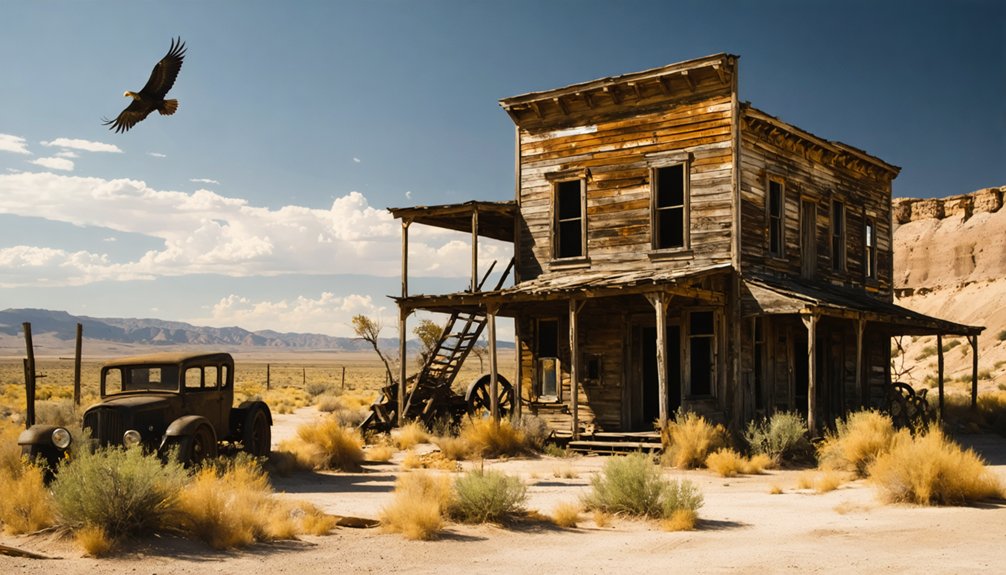
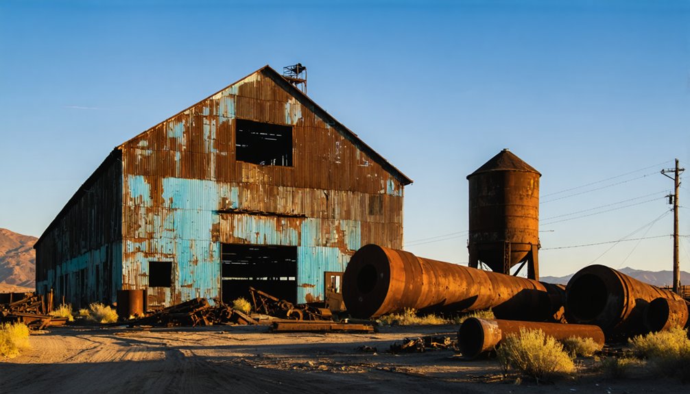
Remnants and Ruins: What Survives Today
Despite years of abandonment and exposure to the harsh elements of the Panamint Mountains, Hodson’s physical remains offer a compelling glimpse into its mining past.
As you explore, you’ll encounter dilapidated wooden and stone buildings, including the former boarding house and mine office, with foundations of processing facilities still visible across the landscape.
The abandoned structures stand alongside scattered mining artifacts—rusting machinery, boilers, and ore carts that once powered the copper operation.
You’ll notice the weathered headstones of Hodson’s cemetery and collapsed cabins dotting the hillsides.
The site’s mine shafts and tunnels remain, though many have become unstable.
Without official preservation efforts, these remnants continue to deteriorate through natural decay, vandalism, and occasional flash flooding that reshapes this remote ghost town.
Hodson During World War II: Copper Processing
World War II dramatically transformed Hodson’s mining landscape as the district pivoted from its gold-mining roots to copper processing operations essential for the war effort.
The Mountain King Mill became the central facility processing copper ore transported from nearby Copperopolis mines, establishing important wartime logistics networks throughout Calaveras County.
The strategic Mountain King Mill transformed Calaveras County through its vital wartime copper processing network.
You’ll find four key aspects of Hodson’s wartime copper operations:
- Transportation infrastructure including railroads and the Mountain Traction Company facilitated continuous ore delivery.
- Processing operations expanded considerably to meet unprecedented copper demand.
- Production peaked in the early 1940s, directly supporting military manufacturing.
- Operations ceased abruptly after 1945 when wartime demand collapsed.
This brief but intense period of industrial activity represents a significant chapter in Hodson’s evolution before its eventual abandonment and ghost town status.
Comparing Hodson to California’s Famous Ghost Towns
As Hodson’s copper processing activities faded into the post-war era, the town began its transformation into one of California’s many ghost towns—though with remarkably different characteristics than its more famous counterparts.
Unlike Bodie or Calico, which attract thousands of tourists annually, Hodson remains largely undiscovered. You won’t find restored storefronts or interpretive centers here.
While Calico underwent extensive commercial restoration and Bodie benefits from state preservation, Hodson comparisons reveal a site largely reclaimed by nature with minimal infrastructure remaining from its mining heyday.
The ghost town characteristics of Hodson emphasize authenticity over accessibility. Its modest population never reached the heights of California’s legendary mining boomtowns, resulting in fewer preserved structures.
This unpolished quality offers you a more genuine, if less spectacular, glimpse into California’s gold mining past.
Frequently Asked Questions
Is Hodson Accessible to Visitors Today?
Yes, you’ll find Hodson accessible via dirt roads requiring high-clearance vehicles. BLM manages this public land where visitor guidelines prohibit artifact removal but allow exploration and photography.
Were There Any Famous Historical Figures Associated With Hodson?
Like a faded photograph, Hodson’s famous residents remain unnamed in historical records. No documented notable figures are associated with this mining district, despite its impressive historical landmarks including the 120-stamp mill.
What Happened to Hodson’s Population After Mining Declined?
You’ll find that Hodson’s population experienced rapid decline as mining impact diminished. Residents dispersed to neighboring settlements seeking economic opportunities, leaving behind vacant structures that would ultimately deteriorate into ruins.
Are There Any Preservation Efforts Underway for Hodson?
As you stand amid Hodson’s forgotten structures, you’ll find no documented preservation efforts currently underway. The site faces significant preservation challenges without community involvement to champion its historical significance.
Did Hodson Experience Any Significant Natural Disasters?
Based on available records, you won’t find evidence of significant earthquake history or flood impact affecting Hodson. The town’s decline stems primarily from economic factors rather than natural disaster events.
References
- https://familyrvingmag.com/2006/02/01/californias-liveliest-ghost-town/
- https://discover.hubpages.com/travel/Ghost-Towns-in-California
- https://en.wikipedia.org/wiki/List_of_ghost_towns_in_California
- https://lonepinechamber.org/history/ghost-towns-of-the-lone-pine-area/
- https://www.youtube.com/watch?v=VR-t5w9wSeU
- https://westernmininghistory.com/library/294/page1/
- https://nvtami.com/2024/02/09/silverado-mine/
- https://www.youtube.com/watch?v=3rUEcDkMrlo
- https://www.youtube.com/watch?v=ElbXVNDurPc
- https://thediggings.com/mining-districts/ca683


