Brownsville, California began in 1851 when I.E. Brown established an $8,000 sawmill in Yuba County’s Sierra Nevada foothills. During the Gold Rush, this settlement flourished around quartz mining operations like Golden Key and Abbott mines, where veins yielded up to 1/3 ounce of gold per ton. Today, you’ll find only skeletal structures and sealed mine shafts marking this ghost town‘s boom-and-bust story. These remnants offer windows into California’s transformative Gold Country era.
Key Takeaways
- Brownsville, established in 1851 by I.E. Brown with an $8,000 sawmill, was part of California’s Gold Rush settlements.
- Mining operations focused on extracting gold from quartz veins within the Calaveras Formation, with notable mines including Brownsville and Golden Key.
- The town declined when gold deposits became harder to access, causing miners to struggle against larger operations.
- After mining declined, Brownsville briefly transitioned to lumber before shifting to agriculture, reflecting California’s broader developmental patterns.
- Today, only skeletal structures and sealed mine shafts remain as historical remnants, attracting tourists interested in California’s boom-and-bust cycles.
The Birth of Brownsville: I.E. Brown’s 1851 Sawmill Settlement
In August 1851, I.E. Brown established what would become Brownsville by constructing an $8,000 sawmill on what was then an undeveloped stretch of Sierra Nevada foothills. This industrial venture marked the first permanent European-American presence in the area, catalyzing community development around the sawmill operations.
Brown, alongside partner John Hoyt, complemented the industrial enterprise with hospitality services, operating a modest log hotel adjacent to the mill. Subsequent development led to the Brownsville Post Office establishment in 1862, marking the settlement’s growth into a recognized community. The settlement drew inspiration from Mormon colonization efforts in California, where settlers had demonstrated remarkable road-building skills when creating access to timber resources.
Enterprising beyond lumber, Brown and Hoyt established the area’s first accommodations—a simple log hotel serving travelers and workers alike.
By November 1852, Brown sold the sawmill to Martin Knox and P.E. Weeks, who continued operations under the name Weeks & Knox. Following this transfer, the settlement officially adopted the name “Brownsville” in honor of its founder.
The mill processed timber from surrounding virgin forests, serving growing demand from California’s expanding settlements until operations ceased around 1857, marking the end of Brownsville’s initial industrial phase.
Geographical Setting: Nestled in Yuba County’s Sierra Nevada Foothills
Nestled between the sprawling Central Valley and the majestic High Sierra, Brownsville occupied a distinctive ecological shift zone within Yuba County’s Sierra Nevada foothills. At roughly 2,000 feet elevation, the town sits where rolling oak woodlands evolve into steeper terrain – a perfect illustration of foothill ecology in evolution.
You’ll find Brownsville positioned among the western slopes’ rugged canyons, where seasonal streams cut through metamorphic bedrock. These topographic features created ideal conditions for early settlers, offering both water resources and protection from valley heat. The town benefits from the longer western slope streams that characterize this side of the mountain range compared to the eastern slope.
The semi-arid Mediterranean climate provides mild winters punctuated by orographic precipitation and warm, dry summers. This area showcases some of the scenic beauty that earned Sierra Nevada its nickname as the Range of Light.
This geographical setting influenced everything from mining operations to agricultural possibilities, as the tilted Sierra Nevada block created alluvial deposits where gold and fertile soils accumulated simultaneously.
Golden Veins: The Geology Behind Brownsville’s Mining Boom
In Brownsville’s heyday, you’d find gold primarily in quartz veins striking northward, ranging from 2 to 5 feet thick and occupying minor reverse faults within the local Calaveras Formation and greenstone.
These valuable deposits occurred most abundantly where the veins interacted with serpentine zones, creating high-grade but erratically distributed ore shoots that yielded anywhere from a few hundred dollars to hundreds of thousands in precious metal.
The richest concentrations typically formed at structural features like vein bends, frayed sections, or junctions—geological sweet spots that attracted miners to this now-quiet corner of Yuba County. Similar to the gold found at Plasherita, California, these deposits consisted of placer gold that had eroded from hard rock systems over millions of years. The area was originally known as Forest diggings when it was first discovered by sailors from San Francisco in the summer of 1852.
Quartz Vein Characteristics
Three distinct structural patterns dominated Brownsville’s gold-bearing quartz veins, creating the geological foundation for the region’s mining boom.
You’ll find these veins striking mainly north-south and east-west through the Mesozoic metaigneous and metavolcanic rocks of the Smartville Complex.
When exploring the area, you’ll notice these quartz vein formations exhibit ribbon structures with crinkly banding, particularly where they cut through Jurassic diorite, gabbro, and amphibolitic schists. Many of these veins demonstrate a moderate dip of 35-50 degrees to either the east or west.
The mineralization processes concentrated native gold alongside pyrite, chalcopyrite, and arsenopyrite, with the richest deposits often occurring where veins fray near serpentinite zones. These deposits are part of the granodiorite association that characterizes the Brownsville-Challenge-Dobbins area.
The region’s hydrothermal alteration zones—marked by sericitization and mariposite—signal proximity to potential high-grade ore, where gold content occasionally reached an impressive 6 oz per ton.
Gold-Bearing Formations
While exploring Brownsville’s gold-bearing formations, you’ll discover a complex geological tapestry that defines the Sierra Nevada Gold Belt in Calaveras County.
The district’s primary gold deposits reside within schist and greenstone, which host the richest quartz veins that fueled the region’s prosperity.
Your gold exploration efforts will be most productive at contacts between different rock types, where tectonic activity created ideal conditions for mineralization.
The district’s argillite, limestone, quartzite, and mica-schist all bear gold potential, though in varying concentrations.
Most profitable mining techniques targeted the reverse faults and shear zones where high-grade ore concentrated, particularly near serpentine bodies.
These formations created a geological paradise for prospectors, with ore shoots yielding tremendous wealth despite their erratic and unpredictable nature.
Similar to Death Valley’s Keen Wonder mine, Brownsville’s gold veins formed when heat and fluids circulated through faults, depositing precious metals at pressure changes.
The mining district was active from 1850 to 1870, when the California Gold Rush brought thousands of hopeful prospectors to this rich area east of Murphys.
Mining Operations: From Quartz Veins to Placer Diggings
The geological complexity of Brownsville’s mining district yielded two distinct yet complementary extraction methods that defined the area’s gold production.
You’d find quartz extraction operations focused on veins one to seven feet thick, typically situated at intrusive-metamorphic contacts where greenstone met gabbrodiorite. These operations yielded 1/7 to 1/3 ounce of gold per ton, with occasional high-grade pockets offering richer rewards.
Meanwhile, placer techniques flourished in areas like New York Flat, where miners recovered coarse gold and nuggets from stream beds using pans, sluices, and hydraulic methods. District regulations prevented monopolization by limiting claims to one wet and one dry site of just 150 square feet each.
As surface gold depleted, mining evolved from manual methods to more sophisticated approaches using stamp mills and advanced sluicing systems.
Notable Mines and Their Golden Legacy
You’ll find the Brownsville Mining District‘s legacy preserved through its numerous productive operations, with strict regulations limiting claims to 150 square feet per miner to manage the area’s abundant gold resources.
The Beehive (Mt. Hope) Mine stands out as particularly significant, earning the nickname “$100,000 mine” due to its exceptional production of high-grade ore that sometimes yielded substantially more than the district’s average of 1/7 to 1/3 ounce of gold per ton.
Golden Key Mine, alongside operations like Abbott and Easy Money mines, contributed to the district’s reputation through their extraction of gold in free form, including nuggets, flakes, and dust from the characteristic quartz veins that defined Brownsville’s mineral wealth.
Mining District Overview
Nestled amid the verdant foothills of Calaveras County, Brownsville Mining District emerged as a significant gold-bearing region during the California Gold Rush, hosting numerous productive mines between 1850 and 1870.
You’ll find it situated along Pennsylvania and Missouri Gulches, roughly two miles from Murphys town, where miners once employed diverse mining techniques to extract both placer and lode gold deposits.
The district’s historical significance is evident in its strict governance – claims were limited to 150 square feet per miner, preventing monopolization while acknowledging the area’s wealth.
Nearby mines like Abbott, Arbucco, and Golden Key yielded impressive results, with ore typically producing 1/7 to 1/3 ounce of gold per ton.
Though the original structures have vanished, commemorative plaques and a miners’ cemetery preserve this chapter of California’s golden past.
Mt. Hope Bonanza
Among the numerous mining operations that characterized the Calaveras County gold landscape, Mt. Hope Bonanza Mine stands as a symbol of California’s golden era.
Located in the Georgetown District of Fornis, this 20.64-acre property rests within the majestic Sierra Nevada range.
You’ll find the mine’s historical significance lies in its classification as a past gold producer, though specific production statistics remain shrouded in mystery.
The underground workings feature typical period mining infrastructure—shafts and tunnels cutting through the earth to access gold-bearing veins.
While mine ownership records aren’t publicly accessible, this doesn’t diminish the property’s relevance to California’s mining heritage.
The Mt. Hope Bonanza, now inactive, represents the freedom-seeking spirit that drove countless prospectors to challenge the mountain’s depths in pursuit of wealth and independence.
Golden Key Operations
While the Mt. Hope mine drew attention for its spectacular bonanza, the Golden Key Mine established itself as another significant contributor to Brownsville’s golden legacy.
Located in northeastern Yuba County, this operation exemplified the district’s typical gold extraction methods, working the rich quartz veins that characterized Sierra Nevada geology.
The mine’s distinctive features included:
- Ore-bearing quartz veins 1-7 feet thick containing free gold with pyrite
- Combined surface and underground mining approaches
- High-grade pockets yielding 1/7 to 1/3 ounce per ton
- Evolution of mining technology from steam-powered equipment to more advanced methods
When you explore Brownsville today, you’re walking above an intricate network of tunnels where miners once pursued these limited but valuable ore shoots through greenstone and gabbrodiorite formations that defined Golden Key’s operations.
Daily Life in a California Mining Community
During the California Gold Rush era, daily life in mining communities like Brownsville reflected the harsh realities of frontier existence balanced against humanity’s enduring need for social connection.
You’d find yourself laboring 12-16 hours daily at your claim, surrounded mainly by men who outnumbered women nine to one. Your housing might be nothing more than a tent or rough-hewn cabin with minimal comforts.
After grueling workweeks, Saturday nights erupted with gambling and drinking in saloons, while Sundays offered respite through community rituals and gatherings.
Mining camaraderie helped offset the isolation and homesickness that plagued these diverse settlements where Chinese, Mexican, European, African American and Native American miners coexisted—though not without tension.
Women, though fewer in number, established essential roles as business owners, laundresses, cooks, and entertainers.
The Fading Rush: Why Brownsville Declined
The once-thriving settlement of Brownsville began its inevitable decline as gold deposits that had lured fortune seekers became increasingly difficult to access and extract profitably.
You’d have witnessed economic shifts as independent miners couldn’t compete with large operations equipped with advanced machinery.
Four key factors sealed Brownsville’s fate:
- Limited ore shoots yielded only 1/7 to 1/3 ounce of gold per ton, making sustained mining unviable.
- Environmental consequences of hydraulic mining led to legal restrictions, including the 1884 ban.
- Change to lumber industry provided temporary relief but eventually succumbed to resource depletion.
- Geographic constraints of the region’s geology prevented expansion of mining operations.
As mines exhausted, population dwindled, with miners either departing or shifting to wage labor, transforming the once-bustling gold camp into today’s ghost town.
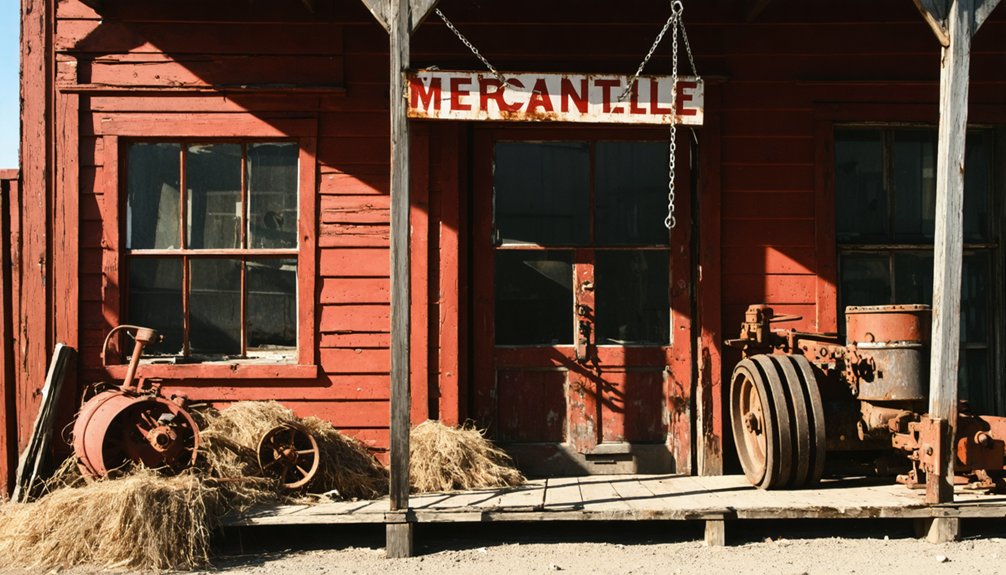
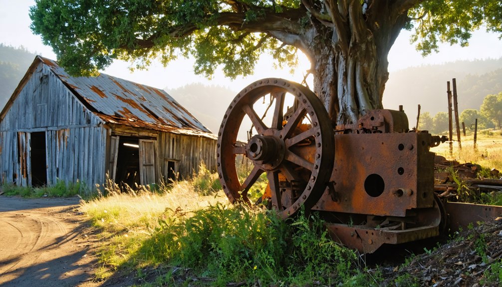
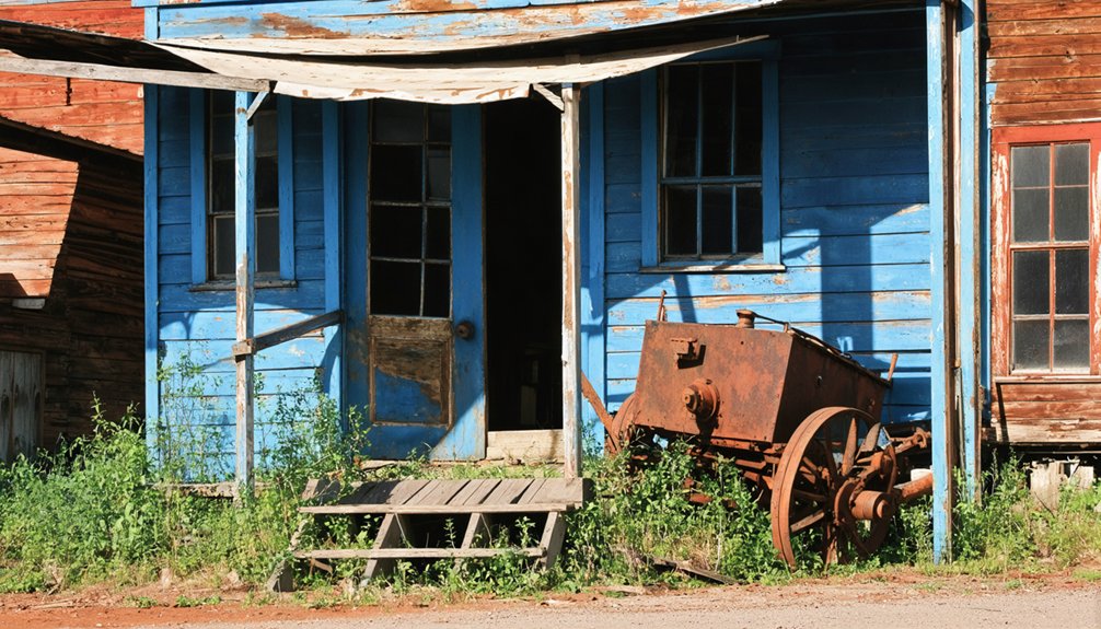
What Remains Today: Visiting Brownsville’s Historic Site
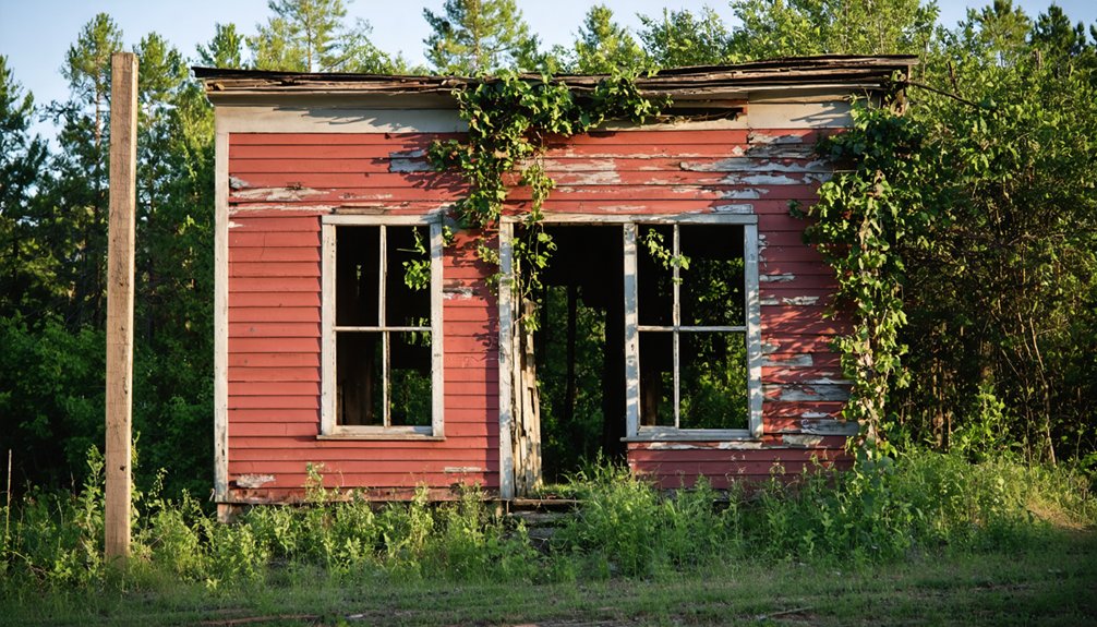
Today’s visitor to Brownsville encounters just three significant physical remnants of this once-vibrant mining community.
Skeletal structures and scattered foundations tell silent stories amid overgrown vegetation, while sealed mine shafts stand as cautionary monuments to the area’s extractive past.
Your ghost town exploration requires self-sufficiency—no visitor centers or amenities exist on-site.
Bring water, navigation tools, and inform others of your plans before venturing here. The site lacks the preservation efforts seen at Bodie, offering instead an unfiltered, raw experience.
Exercise extreme caution around abandoned structures and mine entrances.
While potentially dangerous, these authentic ruins provide unparalleled photographic opportunities and tangible connections to California’s mining heritage.
Unlike curated historic parks, Brownsville delivers freedom to interpret history through its unrestored lens.
Forgotten History: Brownsville’s Place in California’s Gold Country
Nestled among the rolling foothills of northeastern Yuba County, Brownsville emerged in 1850 as a quintessential California Gold Rush settlement that exemplified the era’s frenzied pursuit of mineral wealth.
Named after Alfred Brown, this mining camp became integral to the region’s cultural impact, establishing strict claim regulations that reflected both the democratic ideals and fierce competition of frontier mining.
The district’s legacy encompasses:
- A diverse mining landscape featuring both lode and placer operations
- Stringent 150-square-foot claim limitations ensuring equitable resource distribution
- Mining legends surrounding high-grade pocket discoveries yielding exceptional gold concentrations
- Economic shift from extraction to agriculture, mirroring California’s broader developmental arc
You’ll find Brownsville’s story woven into the larger tapestry of Gold Country settlements that transformed California’s identity forever.
Frequently Asked Questions
Did Any Famous Outlaws or Historical Figures Visit Brownsville?
No evidence confirms any outlaw encounters or historical visitors of fame in Brownsville. You’ll find local legends exist, but they lack credible documentation connecting notable figures to this location.
What Indigenous Tribes Lived in the Brownsville Area Before Settlers Arrived?
Though often overlooked in California’s indigenous history, you’d find Miwuk peoples inhabited the Brownsville region. Their tribal culture thrived in the Sierra foothills long before gold-seekers transformed the landscape forever.
Were There Any Major Disasters or Epidemics in Brownsville?
You’ll find no evidence of epidemic outbreaks in Brownsville’s historical record. While the town experienced typical mining accidents common to Gold Rush settlements, no major disasters precipitated its decline.
Did Brownsville Have Its Own Newspaper or Communication Systems?
You’d search a million years without finding Brownsville newspaper history. No, the town had no dedicated newspaper or formal communication systems—just word-of-mouth exchanges and possibly community bulletin boards for essential communication methods.
What Happened to the Descendants of Brownsville’s Original Mining Families?
You won’t find thorough descendant stories from Brownsville’s original families. They scattered as gold depleted, integrating into other communities, with their mining heritage absorbed into California’s broader Gold Rush narrative.
References
- https://creators.spotify.com/pod/profile/abandonedamerica/episodes/What-Happened-to-Brownsville-e1ohi3l
- https://www.camp-california.com/california-ghost-towns/
- https://dornsife.usc.edu/magazine/echoes-in-the-dust/
- https://crystalcarder.com/realizing-the-demise-of-a-once-booming-city-brownsville-pennsylvania/
- https://westernmininghistory.com/library/227/page1/
- https://thefoothillscabin.com/?view=article&id=5:a-summary-of-the-history-of-brownsville-and-the-yuba-foothills&catid=2
- https://www.hmdb.org/m.asp?m=11501
- https://localwiki.org/yuba-sutter/Brownsville
- https://www.jstor.org/stable/pdf/25178034.pdf
- https://rsc.byu.edu/california-saints/san-bernardino-colony-1851-57


