You’ll find Sugartit, Kentucky, at the intersection of U.S. Route 42 and Kentucky Route 237, where a bustling general store once drew locals with its famous desserts in the late 1800s. Known earlier as Pleasant Ridge and Gunpowder, this unincorporated community declined by the mid-1900s before being annexed by Florence. Today, deteriorating buildings and empty storefronts mark the site’s location, while local storytellers keep the sweet legacy of this uniquely named town alive.
Key Takeaways
- Sugartit, Kentucky was a rural community that declined by mid-1900s and was eventually annexed by the city of Florence.
- The last physical remnants are located at Gunpowder Road and Pleasant Valley Road, featuring deteriorating commercial buildings and homes.
- Originally named Pleasant Ridge in 1883, then Gunpowder in the 1920s, the town got its final name from a popular dessert-serving general store.
- The town’s economic peak occurred in the 1960s with Sugartit Asphalt Company and Haines Oil before experiencing significant decline.
- Abandoned structures show early 20th-century architecture beneath peeling paint and boarded windows, with nature reclaiming the vacant buildings.
The Origins Behind an Unusual Name
While many Kentucky town names have conventional origins, Sugartit’s unusual moniker stems from a popular late 19th-century general store known for its delectable desserts. The store’s sugar culture revolved around fresh-baked pies, donuts, and brownies, attracting local men who’d gather there during cold winter evenings for treats and conversation.
This playful history took shape when wives began teasing their husbands about having a “sugar tit” at the store, referring to their tendency to linger there late into the night. Historically, the term comes from the practice of giving children tied sugar cloths as pacifiers. The community embraced this humorous double entendre, and the name stuck.
Before settling on Sugartit, the town had more traditional names – first Pleasant Ridge in 1883, then Gunpowder in the 1920s – but neither captured the area’s distinctive character quite like its final designation. The community was situated between Florence and Union in Boone County.
Historical Location and Geography
Located in northern Kentucky’s Boone County, Sugartit occupied a strategic position at the intersection of U.S. Route 42 and Kentucky Route 237.
Nestled in Boone County, Kentucky, Sugartit’s location at the crossroads of Routes 42 and 237 proved strategically valuable.
You’ll find this former settlement at coordinates 38°58′22″N 84°39′46″W, nestled between Florence and Union at an elevation of 794 feet above sea level.
The geographic significance of Sugartit stemmed from its proximity to Gunpowder Creek and major regional roadways, making it an accessible hub for local commerce. The term’s origins trace back to the historical use of sugar cloth pacifiers for infants in early American settlements.
The rural characteristics of the area reflected typical Bluegrass Region features, with rolling hills and farmland dotting the landscape. The area now includes views of the iconic Florence Y’all Water Tower, visible to travelers on nearby Interstate 75.
While the settlement’s physical footprint was modest, its position along the Ohio River Valley margins provided the ideal setting for the small but self-sufficient community that once thrived there.
From Rural Hub to Urban Annexation
You’ll find that Sugartit experienced a dramatic shift from its origins as a bustling rural hub with blacksmiths, general stores, and mills in the late 19th century to its eventual decline by the mid-1900s.
The community’s unincorporated status left it vulnerable to Florence’s expanding municipal boundaries, which systematically annexed Sugartit’s territory since the 2000s.
This suburban expansion transformed the former rural settlement into a commercialized corridor along Route 42, complete with fast food outlets, gas stations, and apartment complexes.
Community Growth and Decline
Throughout the early 1900s, Sugartit emerged as a modest but essential rural hub in Boone County, Kentucky, serving local farmers and residents at the intersection of U.S. Route 42 and Kentucky Route 237.
You’ll find the community’s heart at its general store, where locals gathered to trade goods and share stories, embodying the authentic community dynamics of rural Kentucky life. Like many Kentucky settlements, coal mining towns eventually became abandoned as industries changed. Following common patterns of ghost towns, the area’s economic changes eventually led to its decline.
As automobiles became more common and Florence’s urban expansion grew, you’ll note how Sugartit’s significance began to fade.
The rural nostalgia of farm life couldn’t compete with modern conveniences and opportunities in nearby cities. Young residents moved away, and the once-vibrant farming community gradually dissolved, leaving only the Sugartit Asphalt factory as a symbol of its industrial past before being completely absorbed into Florence’s growing boundaries.
Florence’s Expanding City Limits
As Florence evolved from its humble beginnings as Connorsville in 1830, the city’s boundaries began pushing outward through strategic annexations and careful urban planning.
You’ll find that Florence’s first major expansion occurred in 1842, setting the stage for continuous growth that transformed it from a town of just 776 residents in the 1940s to today’s thriving urban center.
The city’s urban expansion has been guided by thoughtful planning, including the 1986 Parkway Corridor Study and the 2002 annexation ordinance. The city’s latest acquisition of 3 1/2 acres along US 42 demonstrates its ongoing commitment to strategic growth.
Recent property acquisitions by the City Council have further extended city boundaries, while updated zoning regulations guarantee sustainable development. The establishment of Florence Mall in 1976 marked a significant milestone in the city’s commercial development.
Florence’s strategic location near Cincinnati and the Northern Kentucky International Airport has made it an attractive destination for commercial investment, fueling its ongoing transformation from rural hub to regional powerhouse.
Economic Life and Local Industry
The economic foundation of Sugartit, Kentucky began in 1883 when the community, then known as Pleasant Ridge, established itself with essential businesses including a blacksmith, general store, steam sawmill, and grist mill.
The local economy centered around agricultural services and resource processing, enabling self-sufficiency for residents. Similar to other Kentucky towns like Barthell, the community relied on resource extraction for stability. The area’s fertile soil made farming a natural cornerstone of the local economy.
Agricultural services and resource processing formed the backbone of the local economy, providing residents with the means to sustain themselves independently.
By the 1920s, you’d find the community, renamed Gunpowder, maintaining fewer but crucial services.
The industrial transformation reached its peak in the mid-1960s with Sugartit Asphalt Company and Haines Oil representing the final chapter of local industry.
- Steam-powered mills processed lumber and grain for regional use
- Blacksmith and general store served farming and household needs
- Asphalt production marked the shift to modern industrial focus
- Economic decline led to absorption into Florence’s suburban landscape
Cultural Impact on Kentucky’s Heritage
While many Kentucky towns have faded into history, Sugartit’s cultural legacy stands out for its uniquely playful name and the folklore surrounding it.
You’ll find that local storytellers keep the town’s spirit alive through tales of winter gatherings at the general store, where men sought both sweets and companionship.
Unlike other Kentucky ghost towns that vanished due to industrial decline or natural disasters, Sugartit’s story reflects a community’s evolving identity through its various names – from Pleasant Ridge to Gunpowder, and finally its memorable moniker.
Through heritage preservation efforts, you can explore this history in local educational programs and cultural events.
The town’s distinctive cultural storytelling continues to enrich Kentucky’s heritage, even after its annexation into Florence, proving that a community’s impact lives on long after its borders disappear.
Legacy of a Lost Community
While you’d find very few physical remnants of Sugartit today, the community’s pride lives on through local storytelling and historical records.
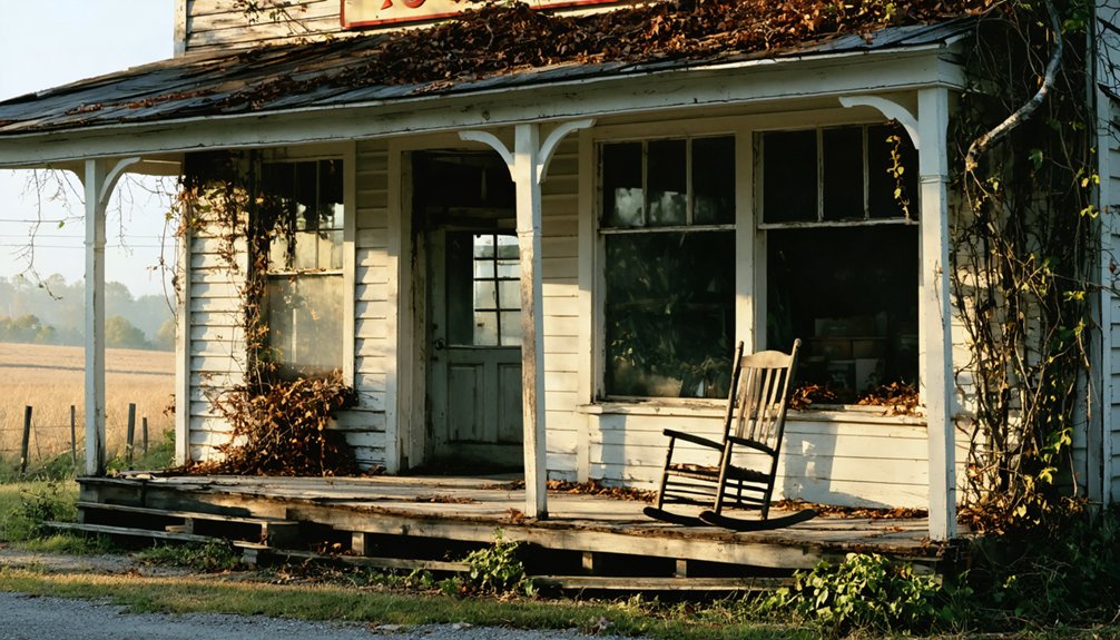
The town’s general store, once buzzing with activity and famous for its sweet treats, now stands empty as a silent witness to the community’s past.
You’ll discover that this Kentucky ghost town‘s most enduring legacy isn’t in its buildings but in its memorable name, which continues to spark curiosity about the state’s small-town heritage.
As you delve deeper into the stories of haunting tales of Sloan, Indiana, you’ll uncover the ghosts of its past, each whispering secrets of the lives once lived there. Visitors often recount eerie encounters, adding to the mystique that envelops this forgotten town. The legends evolve with time, creating a tapestry of folklore that entices both skeptics and believers alike.
Community Pride Lives On
Although Sugartit no longer exists as a physical community, its distinctive name and rich social history continue to spark curiosity and pride among Kentucky residents.
Through community storytelling and emotional connections, you’ll find the town’s legacy preserved in local histories and online discussions that highlight its unique charm and rural traditions.
- The name originated from men’s winter gatherings at the general store, where they’d enjoy sweet treats and companionship.
- Local historians actively preserve stories of the town’s social customs and self-sufficient lifestyle.
- The community’s evolution from Pleasant Ridge to Sugartit reflects the intimate connection between place names and shared experiences.
- Former residents and their descendants maintain strong ties through shared memories and commemorative expressions.
Last Buildings Stand Empty
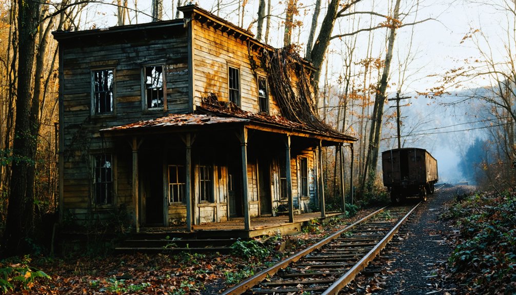
Today at the crossroads of Gunpowder Road and Pleasant Valley Road, you’ll find the last physical remnants of Sugartit – a collection of deteriorating commercial buildings and homes that paint a somber picture of rural decline.
The abandoned architecture tells a story of a once-thriving community, with early 20th-century design features still visible beneath peeling paint and boarded windows. Nature’s steady reclamation is evident as vegetation creeps around foundations, while wildlife claims the empty interiors as their domain.
Ghost town preservation efforts remain minimal, with these historic structures falling victim to structural decay and safety hazards. You can spot unstable roofs, crumbling walls, and broken glass throughout the site, stark reminders of how economic shifts and changing demographics can transform a vibrant town into silent ruins.
the history of three saints bay illustrates a similar plight, where once-thriving communities now struggle against the passage of time. As nature reclaims its territory, remnants of past lives serve as poignant reminders of the legacy that once flourished. The stories embedded in these abandoned spaces invite reflection on both loss and resilience.
Frequently Asked Questions
When Was the Last Resident Recorded Living in Sugartit?
You won’t find an exact date for the last resident, as the community decline was gradual through annexation into Florence. Records don’t document a specific final inhabitant before Sugartit’s complete disappearance.
Were There Any Schools or Churches Established in the Community?
Like many lost pieces of history, you won’t find any documented schools or religious institutions there. Historical records don’t show evidence of established education history or churches in this small community.
What Was the Peak Population of Sugartit During Its Existence?
You won’t find exact peak demographics for this community, as no specific population records were maintained. While the town experienced population decline before annexation, historical figures remain undocumented.
Did Any Notable Historical Events or Figures Emerge From Sugartit?
Like a whisper in history’s wind, you won’t find any notable figures or significant historical events from this community. It remained a quiet rural town until its absorption into Florence.
How Many Businesses Operated in Sugartit Besides the General Store?
You’ll find at least 4 major businesses contributed to the local economy: a blacksmith shop, steam saw and grist mill, paint store, and post office, showing significant business diversity for its time.
References
- https://en.wikipedia.org/wiki/Sugartit
- https://kids.kiddle.co/List_of_ghost_towns_in_Kentucky
- https://blog.kysupplyco.com/sugartit-ky/
- https://www.onlyinyourstate.com/experiences/kentucky/ghost-town-ky
- https://www.youtube.com/watch?v=D9gOmfCuKLs
- https://wbkr.com/visit-these-20-creepy-kentucky-ghost-towns-for-a-halloween-road-trip/
- https://www.cincinnati.com/story/news/local/boone-county/2015/07/12/history-boone-countys-gunpowder-area/30067535/
- https://kids.kiddle.co/Sugartit
- https://www.wcpo.com/news/insider/get-the-scoop-on-all-of-northern-kentuckys-weird-town-names-from-rabbit-hash-to-sugartit
- https://www.freakyfoottours.com/us/kentucky/