Arizona’s forgotten rail infrastructure includes the Roll-Arlington segment abandoned after the 1995 Amtrak derailment, Johnson Canyon Tunnel’s engineering marvel west of Albuquerque, Bisbee Junction’s copper mining network, and Winkelman’s mineral transport lines. You’ll find narrow-gauge remnants of the Magma Arizona Railroad that once served isolated mining communities, while agricultural corridors that revolutionized farm-to-market transport lie dormant. These hidden pathways reveal Arizona’s industrial and economic evolution beneath the desert sun.
Key Takeaways
- Roll to Arlington segment of the Southern Pacific Railroad sits abandoned in southwestern Arizona following a 1995 derailment near Quail Spring Wash.
- Johnson Canyon Tunnel, constructed in 1881, remains largely forgotten despite once supporting up to 3,000 people along the Atlantic & Pacific Railroad.
- Bisbee Junction served as a critical mining rail hub until Southern Pacific absorbed operations in 1924, leaving historical infrastructure behind.
- The narrow gauge Magma Arizona Railroad, built in 1915 for copper transport, features abandoned sections with tight curves and wooden trestles.
- Winkelman Railways, constructed in 1903 and extended to Christmas in 1911, diminished after mine closures with remnants including the 1916 Luten Bridge.
The Lost Middle Segment: Roll to Arlington’s Forgotten Path
While stretching across the arid expanses of southwestern Arizona, the lost middle segment of the Southern Pacific Railroad once provided an essential transportation artery between the small communities of Roll and Arlington.
You’ll find this desert heritage corridor largely abandoned following a catastrophic 1995 Amtrak derailment near Quail Spring Wash—an incident that accelerated Southern Pacific’s decision to cease operations.
Despite periodic discussions of railway restoration, significant obstacles persist: washed-out track sections, abandoned rail cars, and deteriorated infrastructure render rehabilitation financially intimidating.
Dreams of restoring this historic rail corridor continue to derail against the harsh economic realities of desert-damaged infrastructure.
The route’s abandonment reflects broader regional economic shifts, including mining’s decline and highway transport’s ascendancy. The mysterious settlement of Sundad, Arizona was located along this corridor, with limited historical documentation despite its colorful past.
Once critical to settlements like Agua Caliente, which emerged to serve mining and rail traffic, this segment stands as testimony to Arizona’s evolving transportation landscape—passenger rail service through nearby Phoenix having terminated approximately three decades ago.
Like the historic line through Johnson Canyon, these abandoned railways were once considered dangerous transportation routes due to steep inclines and challenging terrain that frequently led to derailments.
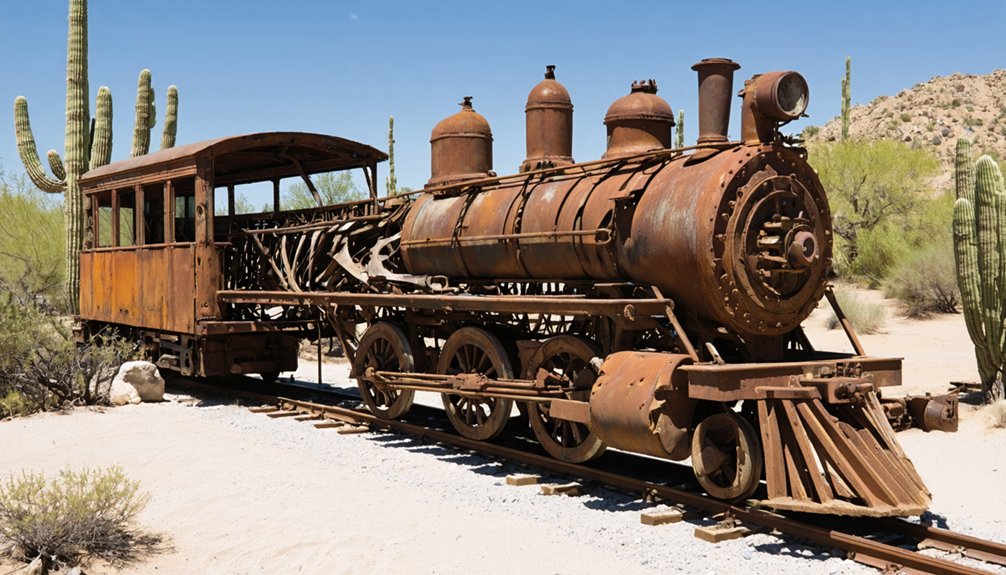
Magma Arizona Railroad: The Narrow Gauge Legacy
The abandoned segments of Arizona’s railway history extend beyond the Roll-Arlington corridor into a remarkable feat of early 20th-century engineering found in the Magma Arizona Railroad. This 36-inch narrow gauge marvel began operating in 1915, spanning 30.19 miles at $197,281—remarkably $9,000 less than constructing just 15 miles of standard track across level desert.
You’ll discover engineering ingenuity throughout Queen Creek Canyon where tight curves and wooden trestles (some still standing) navigated imposing terrain. From May 1915, copper concentrates traveled this route to Webster, transferring to Southern Pacific cars for smelting at Hayden. The railroad served as a vital transportation link for isolated mining communities in central Arizona, supporting local economies through the movement of goods and people. The line officially transitioned to standard gauge track in 1923 after approval came through the previous year, eliminating the need for transfers at Webster.
Copper Kingdom: Bisbee Junction’s Mining Rail Network
You’ll discover Bisbee Junction‘s pivotal role as a mining lifeline when examining how the Arizona and South Eastern Railroad, initiated by Copper Queen Consolidated Mining Company in 1888, transformed copper transport from mule teams to efficient rail networks.
The rail system’s strategic connections to Fairbank, Benson, and eventually El Paso enabled Bisbee’s mines to ship unprecedented volumes of copper ore while reducing freight costs through competitive routing options. The railroad’s completion in 1892 coincided with the Phelps Dodge Company’s largest mining operation in the area, significantly boosting production capabilities.
These critical rail arteries, incorporating both narrow and standard gauge segments to navigate challenging terrain like Mule Pass, facilitated the economic prosperity of Bisbee’s mining operations until underground extraction ceased in 1975. The railroad was completed to connect Bisbee to Fairbank in October 1884, establishing a vital transportation corridor for the region’s mineral wealth.
Mining Line Lifelines
Deep within southeastern Arizona’s rugged landscapes, Bisbee Junction emerged as a critical nexus in the region’s copper mining rail infrastructure during the late 19th century.
You’ll find that February 1889 marked the completion of the Arizona and South Eastern Railroad, revolutionizing copper transportation by connecting Bisbee to Fairbank and integrating with the Southern Pacific’s westward routes.
This intricate mining infrastructure evolved substantially when El Paso and Southwestern Railroad acquired these lines in 1901, extending connections to Douglas and establishing cross-border links via the Nacozari Railroad. The Southern Pacific Railroad later absorbed these operations in 1924, further consolidating the regional rail network.
The Warren-Bisbee Electric Railway complemented this network from 1908, transporting miners on shift schedules while hauling essential equipment through Tombstone Canyon.
These pioneering railways reduced freight costs dramatically, allowing the copper kingdom to flourish while supporting the movement of coke, bullion, and timber throughout the expanding mining district. The vast network serviced approximately 2,400 miles of underground tunnels, creating one of the most extensive mining transportation systems in American history.
Tunnels Through Time
Winding through Arizona’s rugged terrain, Bisbee Junction‘s intricate network of tunnels formed the backbone of the region’s copper kingdom transportation infrastructure from 1888 to 1924.
You’ll discover these abandoned tunnels once served as essential arteries when the Arizona and South Eastern Railroad Company carved paths through Mule Pass to connect Bisbee’s mining operations with the outside world.
The historical routes represent engineering triumphs that dramatically reduced shipping costs, transforming Bisbee’s economic landscape.
When the El Paso and Southwestern Railroad acquired these lines in 1901, they continued expanding the network eastward, ultimately connecting to the Atchison, Topeka and Santa Fe Railroad at Deming.
The Southern Pacific’s 1924 acquisition marked the final chapter of this network’s original operation.
Today, these silent passages stand as monuments to an era when competing rail lines fueled the region’s copper mining expansion and transported millions of tons of ore that helped Bisbee produce around 8 billion pounds of copper during its nearly century-long mining history.
Engineering Marvel: Johnson Canyon Tunnel’s Hidden History
Hidden beneath the rugged landscape of northern Arizona, the Johnson Canyon Tunnel stands as a remarkable feat of 19th-century engineering ingenuity. Commenced by the Atlantic & Pacific Railroad in April 1881, this 328-foot passage was the sole tunnel west of Albuquerque, created to avoid costly southern detours.
The tunnel engineering faced formidable challenges—steep inclines and rugged canyons required bridging two treacherous gorges. Construction progressed slowly amid significant human cost, including a premature explosion that killed six workers in August 1881. The tunnel’s route featured an extreme 112-foot drop per mile through the canyon, presenting additional engineering difficulties.
After an 1898 fire caused a devastating rockfall, engineers deepened and reinforced the structure.
Despite its historical significance in western development, this once-bustling site that supported 1,500-3,000 people has faded from memory. You’ll find remnants of this marvel via I-40’s exit 151, where train parts still litter the canyon floor.
Corrizo Gorge: Nature Reclaiming the Rails
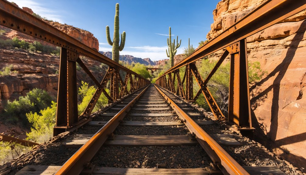
Carved through the formidable landscape of Arizona’s southeastern region, Carrizo Gorge represents one of the most challenging railway constructions in American history—an 11-mile stretch requiring seventeen tunnels and fourteen wooden trestles to navigate its precipitous terrain.
Since its 2008 abandonment, nature’s reclamation process has accelerated dramatically. The $19 million “Impossible Railroad” now stands as a monument to engineering ambition overwhelmed by environmental forces.
Weather-induced rockslides obstruct tunnels that once echoed with locomotive thunder, while desert vegetation systematically infiltrates wooden trestles weakened by decades of fire damage and decay.
Despite multiple operators’ restoration attempts between 1979-2020, the harsh climate and remote location have thwarted every effort to resurrect consistent service.
The dormant line remains suspended between human achievement and wilderness—a technical marvel surrendering gradually to the desert’s patient persistence.
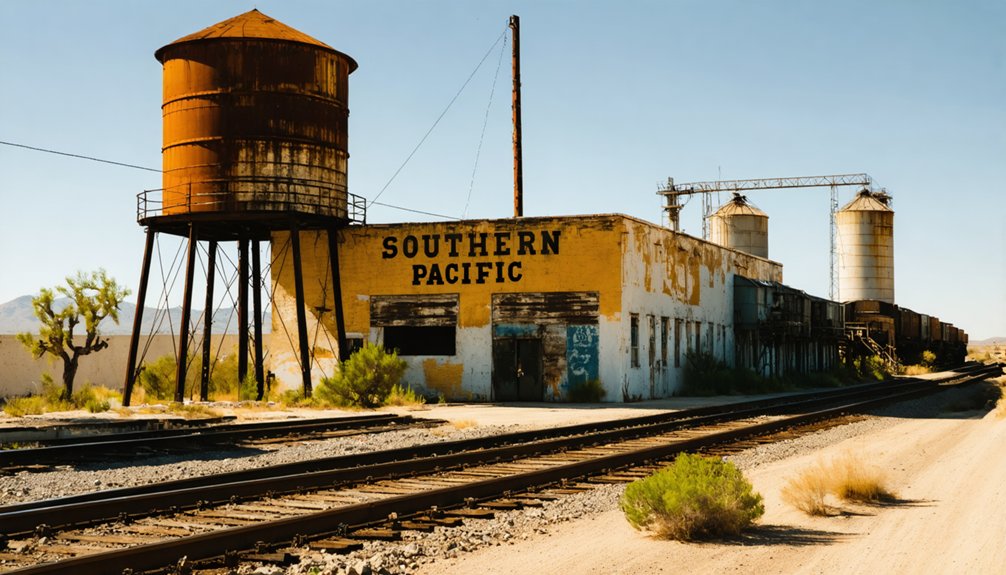
Desert Ghosts: Winkelman and Christmas Mining Connections
While Arizona’s southeastern canyons challenge railway persistence, the central mining corridor presents a different narrative of railroad abandonment.
The remnants of abandoned rail stockyards in Arizona can be seen as a testament to the changing economic landscape. Once bustling with activity, these areas now serve as quiet reminders of the past, where trains once transported goods vital to the region’s development. As nature reclaims these spaces, they transform into unique habitats, attracting wildlife and offering glimpses into a forgotten era.
The Phoenix and Eastern Railroad constructed the Winkelman Railways in 1903, establishing a critical mineral transport artery that Southern Pacific acquired by 1907.
You’ll find that the 1911 extension to Christmas represents a quintessential mining-driven rail development. This 6.35-mile segment specifically served the Christmas Copper operations, exemplifying the symbiotic relationship between extraction industries and rail infrastructure.
When the mine ceased operations in the 1950s, the line’s purpose diminished.
The rail corridor changed hands multiple times—Southern Pacific abandoned it in 1961, followed by Kennecott Copper’s ownership, then Copper Basin Railway in 1986.
Today, only scattered remnants persist, with the 1916 Winkelman Luten Bridge standing as a technical embodiment to this industrial heritage.
Agricultural Lifelines: When Trains Served Arizona’s Farming Communities
When Southern Pacific Railroad extended into Arizona by 1880, you’re witnessing the pivotal infrastructure that transformed isolated agricultural settlements into viable commercial centers.
You’ll find that Mesa, Glendale, and other valley communities depended entirely on these rail connections to ship cotton, produce, and livestock to distant markets at rates of $0.15 per ton-mile.
The intricate network of branch lines, including the Maricopa and Phoenix Railroad, created farm-to-market corridors that sustained agricultural development while simultaneously enabling the environmental consequences of overgrazing that would reshape Arizona’s landscape.
Produce-Laden Cotton Express
The Cotton Belt Railroad, established in Arizona in 1932, transformed the state’s agricultural economy by creating essential transportation arteries that connected remote farming communities to lucrative national markets.
This extensive network facilitated unprecedented cotton transport volumes, moving thousands of tons annually from Maricopa County, Casa Grande Valley, and Gila River farms.
You’ll find evidence of agricultural connectivity in abandoned rail spurs that once served Tucson’s bustling cotton yards and Yuma’s produce-loading facilities.
The railroad’s refrigerated cars revolutionized Arizona’s agricultural potential, enabling farmers to ship perishable citrus, lettuce, and melons to distant consumers.
Cotton Belt’s infrastructure reduced transportation costs while expanding market access, allowing farmers to increase acreage and diversify crops.
Though trucking eventually superseded rail shipping, these forgotten corridors represent a critical chapter in Arizona’s agricultural development.
Desert Irrigation Networks
Ancient desert irrigation networks laid the groundwork for Arizona’s agricultural transformation long before railways crisscrossed the landscape.
The Hohokam people engineered a remarkable system between A.D. 200-1450—one of the Western Hemisphere’s largest preindustrial irrigation achievements—supporting populations of 20,000 in the Salt River Valley.
You’ll find these ingenious waterways reimagined in the 19th century when settlers established irrigation companies like Swilling’s in 1867, deliberately following ancient Hohokam irrigation pathways.
The technological evolution continued with Roosevelt Dam (1905-1911), which stabilized water supplies and expanded agricultural capacity.
This hydraulic infrastructure eventually necessitated rail transport, as desert lands transformed into productive fields requiring efficient export channels.
The convergence of ancient agriculture techniques and modern transportation networks created the foundation for Arizona’s agricultural economy.
Farm-to-Market Rail Connections
Arizona’s agricultural landscape underwent a profound transformation following the arrival of the Southern Pacific Railroad in 1877, establishing essential farm-to-market connections that would redefine rural economies throughout the territory.
Rail transport revolutionized previously isolated farmland, dramatically increasing land values and productivity through efficient shipment of equipment, seed, and harvested crops.
You’ll find evidence of this agricultural impact in the remnants of branch lines that once connected communities in Maricopa, Pinal, and Yuma counties.
The innovation of refrigerated boxcars proved particularly consequential, enabling Arizona farmers to ship perishable citrus and vegetables to distant markets.
Icehouses at rail depots—now largely abandoned—served dual purposes as cooling stations and community gathering points.
Frequently Asked Questions
How Can I Legally Explore Abandoned Rail Sites in Arizona?
Obtain legal permissions from landowners or railroad operators before exploration. Follow established guidelines: respect posted signs, use public rail-trails, consult historical societies, and adhere to safety protocols while documenting your discoveries.
What Safety Concerns Exist When Visiting These Remote Railroad Areas?
Walking into a desert time capsule, you’ll face structural collapse risks, wildlife hazards including venomous reptiles, extreme temperatures, trespassing risks, limited cell service, and dangerous terrain requiring proper preparation and navigation tools.
Are There Guided Tours Available for Historic Arizona Rail Routes?
Yes, you’ll find guided tours on historic routes via Verde Canyon Railroad, Grand Canyon Railway, and Arizona Eastern Railway, all offering meticulously curated excursions through Arizona’s rail heritage landscapes.
Which Abandoned Arizona Rail Sites Are Accessible Without 4WD Vehicles?
Like threads in time’s tapestry, historic railroads with easy access include the Mineral Belt Railroad Tunnel near Payson, Johnson Canyon Line near Ashfork, and Maricopa and Phoenix Railroad—all accessible via standard vehicles or moderate hiking trails.
What Photography Permits Are Needed for Abandoned Railway Documentation?
You’ll need permits based on land ownership: ADOT permits for highway-adjacent sites, BLM/Forest Service permits for federal lands, and county permits for local jurisdictions. Research specific photography rights before documenting abandoned railways.
References
- https://www.abandonedrails.com/roll-to-arlington
- https://www.abandonedrails.com/arizona
- https://www.abandonedrails.com/magma-arizona-railroad
- https://www.american-rails.com/az.html
- https://wiki.openstreetmap.org/wiki/Arizona/Railroads
- https://www.youtube.com/watch?v=_aoqSwyZpJA
- https://www.rodeo-labs.com/the-impossible-railroad/
- https://www.youtube.com/watch?v=43FJKKY6Bn4
- https://www.youtube.com/watch?v=eKMSVZZ2ZQ0
- https://en.wikipedia.org/wiki/List_of_passenger_train_stations_in_Arizona


