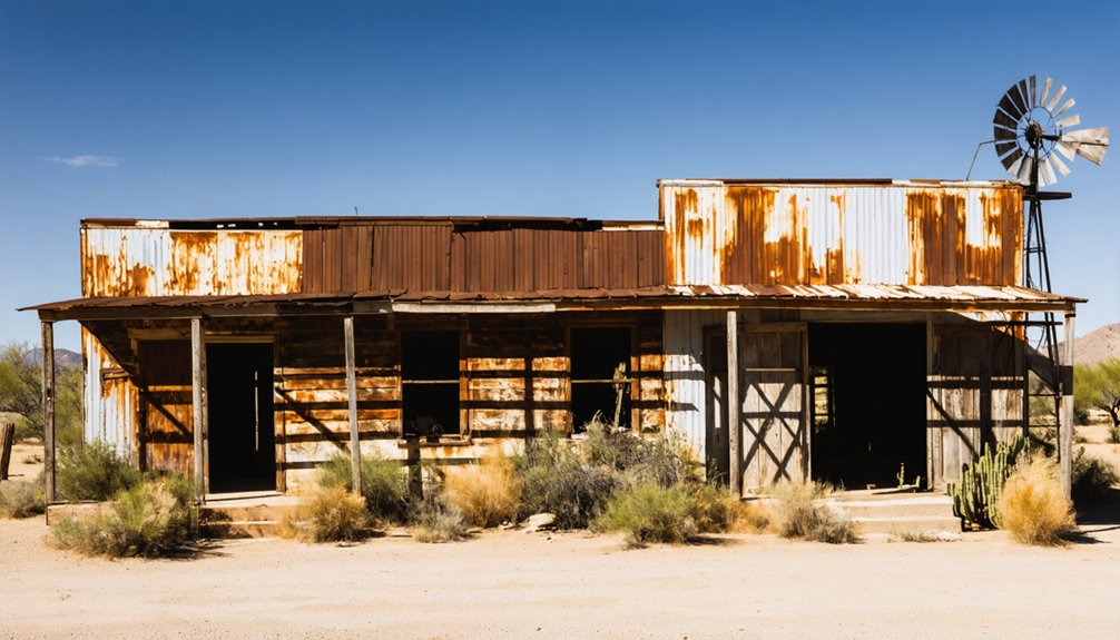
You’ll find Arizona’s abandoned railroad junctions scattered across 600 miles of desert terrain, with roots dating back to 1895. The Southern Pacific’s Florence Branch served as the original mainline east of Phoenix, while the Magma Arizona Railroad (1914-1967) transformed from narrow-gauge to standard gauge in 1923. Notable sites include the Roll-Arlington line (abandoned 1996) and the historic Bisbee-Fairbank route (1890). These weathered remnants, from mining connections to cattle operations, hold untold stories of the Southwest’s rail heritage.
Key Takeaways
- The Florence Branch of Southern Pacific Railroad, operating since 1895, became abandoned after the mainline was rerouted through Magma.
- The Roll to Arlington line was abandoned in 1996, representing one of many historic rail corridors lost across Arizona.
- Bisbee to Fairbank route, established in 1890, stands as a significant abandoned junction reflecting Arizona’s mining transportation history.
- Abandoned junctions throughout Arizona face ongoing deterioration from vandalism and neglect, complicating preservation efforts.
- Approximately 600 miles of Arizona railroad tracks have been abandoned since 1920, creating numerous defunct junctions across the state.
The Southern Pacific’s Lost Legacy: Dock to Poston Station
Although the Southern Pacific Railroad’s Florence Branch between Dock and Poston Station now exists only in historical records, this short but strategic rail segment operated as early as 1895, serving as the original SP mainline east of Phoenix before its eventual rerouting through Magma.
You’ll find no trace of this historic junction today, as all infrastructure has been removed, leaving only scattered ballast rocks marking the former right-of-way. The raised grade area near Parsons remains visible but has largely been overtaken by sagebrush growth.
The branch played an essential role for regional railways, particularly the Copper Basin Railway, which used it as an important connection to Southern Pacific’s mainline at Poston Station. Following the pattern of its parent company’s extensive growth, the line became part of Southern Pacific’s strategic acquisitions that helped establish its dominance across the western United States.
Ghost Rails of the Santa Fe: Ash Fork to Crookton
The Santa Fe Railway’s storied Ash Fork to Crookton segment witnessed its final freight movement in December 1960, marking the end of an era for this 16.1-mile stretch of mainline track.
You’ll find this abandoned route, once essential to the Southern Transcon between Chicago and Los Angeles, curved northwest from MP 402.0 to MP 418.1.
The railway heritage of this corridor dates to the early 1900s when double-tracking added a southern alignment to complement the original northern loop.
Double-tracking initiatives in the early 1900s expanded this vital corridor, adding a southern path alongside the existing northern route.
By 1959, Santa Fe received abandonment authorization, choosing to bypass Johnson Canyon via the new Crookton Cutoff.
Today, this ghost rail corridor joins Arizona’s collection of ghost towns, with only traces visible from I-40’s Exit 139.
The history of adamana, arizona is rich with stories of the past, from its bustling days as a waypoint on the railway to its eventual decline. Visitors can explore what remains of the town, offering a glimpse into the lives of those who once called it home. As you venture through the area, the remnants of abandoned buildings and old tracks evoke a sense of nostalgia and mystery.
The 44-mile double track construction project created a more efficient route several miles north of the existing main line.
The magnificent Escalante Hotel served passengers until its closure in 1948, marking the beginning of Ash Fork’s railway decline.
Ash Fork’s decline accelerated after the bypass, leaving just the freight house as evidence of its railroad past.
Mining Town Connections: The Bradshaw Mountain Railroad
You’ll find the Bradshaw Mountain Railroad‘s 1901 incorporation marked the beginning of a crucial mining transportation network, connecting to the Santa Fe, Prescott and Phoenix Railroad through two strategic branches – the Poland Branch and Crown King Branch.
The railroad’s construction through the rugged Bradshaw Mountains required extraordinary engineering solutions, including a 200-foot tunnel, thirty-one wooden trestle bridges, and ten switchbacks to navigate the challenging terrain. The Poland Branch faced unique challenges when labor shortages occurred as workers abandoned their posts to pursue gold discoveries in the region. Construction teams comprised of skilled workers from Indian, Mexican, Greek, and Italian backgrounds contributed their masonry expertise to complete the project.
When completed in 1904, you could witness daily train service operating across this marvel of early 20th-century railroad engineering, which transported valuable ore from numerous gold, silver, and copper mines until its abandonment by Santa Fe Railway two decades later.
Route Through Mining Communities
Operating through Arizona’s rugged Bradshaw Mountains, the Santa Fe, Prescott and Phoenix Railroad incorporated its mining branch line on February 6, 1901, stretching 35.6 miles across mineral-rich terrain.
You’ll find two distinct branches: the Poland Branch following Big Bug Creek for 8 miles to Poland Mine, and the Crown King Branch ascending to 6,000 feet elevation.
The railway’s strategic route connected crucial mining communities like Huron, Poland, Mayer, and Crown King, revolutionizing mining transportation throughout the region.
The standard gauge track allowed for efficient operations across the challenging mountain terrain.
You’ll spot colorfully named stops like Big Bug, Bumble Bee, and Rich-in-Bar along the way.
This essential infrastructure sparked significant community growth in Prescott and surrounding areas, as the railroad’s efficiency in ore transport dramatically reduced shipping costs compared to traditional muleback hauling methods.
The initial construction progressed rapidly with 350 diverse workers hired at one dollar per day until a gold discovery disrupted the workforce.
Engineering Feats and Challenges
Building this ambitious railroad required extraordinary engineering prowess to overcome the Bradshaw Mountains’ formidable terrain.
Under the leadership of Frank Murphy’s vision, the seemingly impossible project transformed the region’s transportation capabilities. You’ll find remarkable engineering innovations throughout the line, including ten strategic switchbacks and thirty-one wooden trestle bridges that conquered seemingly impossible grades up to 3.9%. The construction obstacles were relentless, with crews battling harsh winter conditions while drilling through solid rock. The hazardous conditions led to numerous crew casualties during construction.
- A 142-foot tunnel carved through mountain rock demonstrated the era’s advanced engineering capabilities.
- Nearly 600 workers established camps at Middleton to tackle the challenging 13-mile stretch.
- Standard-gauge track installation on 2,400 feet of elevation gain proved revolutionary for mountain railroading.
The most demanding section through Crazy Basin required extensive blasting and creative solutions, transforming what was once a $21.50-per-ton mule route into an efficient rail network.
Copper and Cattle: Rise and Fall of the Magma Arizona Railroad
If you’d tracked the Magma Arizona Railroad‘s trajectory from 1914 to 1967, you’d have witnessed its evolution from a narrow-gauge industrial shortline into Arizona’s premier copper ore carrier.
You’d have seen its 30.19-mile route transform in 1922-23 from 36-inch gauge to standard gauge track, enabling seamless connections with Southern Pacific’s network at Magma Junction.
Operating the last commercial steam locomotives in the continental U.S. until 1967, this historic shortline transported millions of tons of copper ore while serving local cattle operations throughout the Superstition Mountain region.
Industrial Railway’s Glory Days
When the Magma Copper Company constructed its 31-mile Magma Arizona Railroad in 1915, they’d establish one of Arizona’s most significant industrial rail lines.
Initially built as a 36″ narrow gauge system to minimize costs, the railroad’s conversion to standard gauge by 1923 marked its transformation into a powerful copper mining and ranching artery.
The railroad’s economic impact revolutionized local industry through:
- Reducing copper concentrate transport costs from $10 per ton via mule teams
- Creating a crucial link between Superior mines and the Hayden smelter
- Supporting cattle operations with strategic loading facilities at Hewitt Station until 1943
You’ll find this industrial railway became the backbone of Pinal County’s economy, spurring development while simultaneously serving both mining interests and local ranchers during its peak operational years between 1920-1943.
Last Steam Short Line
The Magma Arizona Railroad’s distinction as the last steam-powered short line in the continental United States marked a significant chapter in American railroad history.
You’ll find this remarkable line operating steam locomotives until 1967, well after most railroads had converted to diesel power. The shift began on August 22, 1958, when diesel locomotives first entered service, but the steam engines weren’t quickly retired.
The final steam operations saw Engine No. 6 retire on January 7, 1961, followed by Engine No. 7 on June 10, 1967.
Engine No. 5 made its last revenue run on September 5, 1967, before being placed on standby.
Baldwin DRS-6-6-1500 No. 10, built in 1950 and acquired in 1969, represented the new era of diesel power on this historic short line.
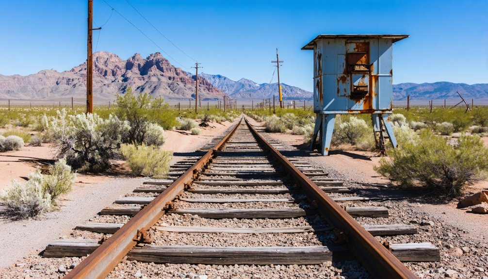
Desert Remnants: Mapping Arizona’s Abandoned Rail Corridors

Stretching across Arizona’s rugged landscape, abandoned rail corridors reveal a complex network of historical transportation routes that once connected essential mining, ranching, and industrial hubs throughout the state.
You’ll find these abandoned landscapes particularly concentrated in the southern and central regions, where 600 miles of track have vanished since 1920.
- The Roll to Arlington line, abandoned in 1996, requires 4WD exploration through remote terrain from Wellton to Phoenix
- The historic Bisbee to Fairbank route, dating to 1890, winds through Mule Mountain and Lewis Springs
- The El Paso & Southwestern system’s 1,200-mile network merged with Southern Pacific in 1924, leaving historical connections now largely abandoned
These historical arteries trace Arizona’s industrial evolution, from copper mining booms to timber operations, with many corridors now accessible only through detailed mapping and off-road exploration.
Engineering Challenges: Trestles, Tunnels, and Terrain
When you study the mountain pass construction hurdles of Arizona’s abandoned rail corridors, you’ll encounter engineering feats like the twenty trestles required for just eleven miles through Carrizo Gorge in 1919.
You’ll find that engineers faced near-impassable conditions with gigantic boulders, deep valleys, and earthquake-prone ridges that demanded complex solutions like the 600-foot Goat Canyon trestle.
To combat desert flooding threats, railroad builders in 1912 implemented robust designs like the Salt River Bridge’s steel truss system and strategic route selections that balanced direct paths against the need for flood-resistant infrastructure.
Mountain Pass Construction Hurdles
As railroad engineers tackled Arizona’s challenging mountain passes in the early 20th century, they faced formidable engineering obstacles that demanded innovative solutions.
You’ll find their greatest challenges centered around tunnel stabilization through unstable rock formations and trestle durability across deep gorges.
Consider these critical hurdles they overcame:
- Massive rockslides that crushed tunnel sections, requiring $250,000+ repairs and multi-week closures
- Temperature extremes exceeding 110ºF that stressed bridge materials and complicated maintenance
- Unstable geological conditions with rifts hundreds of feet deep that threatened infrastructure
Construction crews deployed steam shovels and 100-man teams to blast through mountains and clear debris.
Their ingenuity created a remarkable network of 21 tunnels spanning three miles, alongside 2.5 miles of bridges and trestles that conquered Arizona’s rugged terrain.
Desert Flooding Prevention Solutions
Throughout the 1920s, railroad engineers developed sophisticated flood control systems to protect desert rail infrastructure from seasonal monsoons and flash floods.
You’ll find their innovative solutions in the repurposed trestles of the Randolph South Detention Basins, where they integrated concrete cart paths and bridges for dual functionality during low-flow periods.
The most ambitious project emerged with the Buckskin Mountain Tunnel, a 7-mile engineering marvel capable of channeling 3,000 cubic feet per second of floodwater.
They’d reinforced it with 3.5-ton precast concrete segments to guarantee longevity. The design maintained ecological balance through metered outflow via concrete box culverts, while supporting local wildlife with strategically placed rubble-pile clusters.
Despite high costs and constructability challenges in desert terrain, these adaptations have proven essential for protecting Arizona’s rail corridors from devastating flash floods.
Economic Forces Behind Rail Line Closures
Since the late 20th century, Arizona’s abandoned railroad junctions reflect complex economic forces that have reshaped the state’s freight transportation landscape.
The economic impact becomes evident through the $18.8 billion funding gap for rail infrastructure maintenance through 2043, while shifting commodity patterns have drastically altered rail demand.
Key factors driving rail junction abandonment include:
- Coal’s decline from over 50% of rail freight, destabilizing traditional revenue streams
- Lack of dedicated state funding sources for freight rail preservation
- Competition from expanding road networks and efficient trucking logistics
From Rails to Trails: Current Status of Historic Routes
The transformation of Arizona’s abandoned rail corridors into recreational trails represents one of the state’s most notable land-use adaptations of the 21st century.
Arizona’s visionary repurposing of old railway paths into vibrant community trails marks a defining shift in how we reimagine forgotten spaces.
You’ll find premier urban trailways like Tucson’s Chuck Huckelberry Loop, spanning 155 miles with 60+ art installations, and the award-winning Rillito River Park Trail extending 137 miles.
While metropolitan conversions thrive, many rural routes remain unmaintained. The ecological impacts vary greatly: well-maintained urban corridors preserve native habitats along riverbeds, while neglected rural segments face erosion challenges.
You can explore these changes through crowd-sourced mapping tools like the Abandoned & Out of Service Railroad Lines Map, though documentation quality differs by location.
The Santa Cruz Loop and River Park Trail exemplify successful conversions, earning national recognition for their integration of transportation history with modern recreational demands.
Junction Points: Where Major Railways Once Met

While Arizona’s railway system once boasted an intricate network of junction points, several major intersections stand out for their historical significance in the state’s railroad development.
Railway intersections like the Santa Fe’s Ash Fork junction, abandoned in 1960, and the El Paso & Southwestern’s Douglas connections showcase the evolution of Arizona’s rail infrastructure.
Key junction significance across the state included:
- The Magma Arizona Railroad’s Hewitt Station, which served as a crucial cattle loading point until 1943
- The Arizona & South Eastern’s Benson junction, linking to Southern Pacific routes
- The El Paso & Southwestern’s strategic mining connections, serving Bisbee and Douglas until the 1990s
You’ll find these abandoned junctions reflect broader shifts in transportation needs, from mining operations to passenger service, marking pivotal changes in Arizona’s railway history.
Preservation Challenges in Arizona’s Railroad Heritage
Maintaining Arizona’s historic railroad heritage faces unprecedented challenges in 2024-2025, as severe funding shortfalls threaten to shutter the Arizona State Historic Preservation Office (SHPO) by August 2025.
With SHPO relying on 87% federal funding, delayed reimbursements and proposed cuts jeopardize essential preservation efforts statewide.
You’ll find regulatory challenges compounding these preservation funding issues. Arizona’s Proposition 207 (2006) requires compensation for preservation restrictions on private property, while infrastructure projects like broadband expansion and port development threaten historic rail sites.
Emergency state funding of $865,000 provides temporary relief, but long-term solutions remain uncertain.
Meanwhile, abandoned junctions suffer from neglect and vandalism, as preservation teams struggle to balance economic development with heritage conservation under increasingly complex legal and financial constraints.
Frequently Asked Questions
Are There Any Hidden Treasures Along Abandoned Arizona Railroad Routes?
You’ll find hidden artifacts through treasure hunting along 1920s-1960s routes, including rail spikes, mining equipment, telegraph poles, and personal items near places like Johnson Canyon and Magma Arizona Railroad.
Can Tourists Legally Explore These Abandoned Railroad Sites Today?
Like forbidden fruit in a steel garden, you’re limited to legal access through official tours and converted public trails. Most abandoned sites remain off-limits due to private ownership and tourist safety concerns.
What Wildlife Now Inhabits These Abandoned Railroad Corridors?
You’ll find bobcats, mountain lions, javelina, mule deer, and Sonoran pronghorn showing remarkable wildlife adaptation in these corridors, demonstrating positive ecological impact through their strategic use of underpasses and connectivity pathways.
Did Any Famous Train Robberies Occur on These Now-Abandoned Lines?
You’ll discover famous train heists by legendary outlaws like Three-Finger Jack’s 1900 Fairbank robbery and the Canyon Diablo station’s 1889 incident where four bandits staged a $30,000 dynamite-powered holdup.
Which Native American Tribes Were Impacted by These Railroad Abandonments?
Like tracks vanishing into desert sand, you’ll find the Navajo, O’odham, and Apache peoples saw their economies fade after 1950s abandonments, particularly affecting traditional trade routes and wage-earning opportunities.
References
- https://www.abandonedrails.com/dock-to-poston-station
- https://forum.trains.com/t/the-old-abandoned-at-sf-transcon-in-arizona-w-photos/214471
- https://www.abandonedrails.com/tempe-branch
- https://en.wikipedia.org/wiki/Bradshaw_Mountain_Railroad
- https://www.abandonedrails.com/magma-arizona-railroad
- https://en.wikipedia.org/wiki/San_Pedro_Valley_Railroad
- https://www.youtube.com/watch?v=6jdvxCj5rMc
- https://www.abandonedrails.com/arizona
- https://www.abandonedrails.com/florence-branch
- https://en.wikipedia.org/wiki/History_of_the_Southern_Pacific_Railroad