You’ll discover Nevada’s abandoned mining towns from a breathtaking aerial perspective through modern drone technology. High-resolution cameras capture the iconic structures of Rhyolite, Blair’s fragmentary remains, and the distinctive layouts of Goldfield and Nelson against the desert backdrop. From above, you can identify residential clusters, community hubs, and mining infrastructure that tell stories invisible from ground level. The state’s arid climate and geographic isolation preserve these historical treasures for your exploration.
Key Takeaways
- Drone technology captures high-resolution aerial photographs revealing hidden patterns and layouts of Nevada’s historic mining ghost towns.
- From above, iconic structures like Rhyolite’s bank and distinctive mining infrastructure become visible against desert landscapes.
- Aerial views expose residential clusters, community hubs, and mining operations not discernible from ground level.
- Nevada’s arid climate and geographic isolation preserve ghost town remains, making them ideal subjects for aerial photography.
- Resources like Google Earth, USGS maps, and specialized websites provide coordinates and context for aerial ghost town exploration.
Capturing Nevada’s Mining Past: Drone Technology and Aerial Photography
While traditional photography has long documented Nevada’s mining heritage from ground level, modern drone technology now reveals these historic sites from perspectives once accessible only to birds.
You’ll discover a new dimension to these abandoned towns as high-resolution cameras mounted on lightweight drones capture the sprawling layouts of mining operations against rugged desert backdrops.
With extended flight times and GPS stabilization, you’re free to explore vast mining districts in a single session, revealing spatial relationships impossible to grasp from the ground.
Aerial freedom unlocks mining landscapes, revealing patterns and connections invisible to earthbound explorers.
Remember that drone safety isn’t just about protecting your equipment—it’s about preserving these fragile historic sites.
Embrace photographic ethics by respecting private property boundaries and cultural sensitivities while documenting these vanishing treasures before time claims them completely.
Eldorado Canyon near Nelson offers exceptional aerial photography opportunities with its collection of rusted antique cars and mining equipment creating visually striking patterns from above.
Researchers can reference the Nevada Mining District Files for historical context when planning aerial photography expeditions of abandoned mining sites.
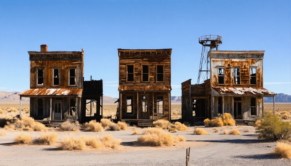
Top Ghost Towns Revealed From Above: Rhyolite, Blair, and Beyond
From the sky, Nevada’s forgotten mining communities transform into haunting patterns etched across the desert landscape.
During your Rhyolite exploration, you’ll spot the iconic three-story bank and Tom Kelly’s Bottle House standing defiant against time at 3,800 feet elevation near Death Valley.
The railroad depot and jail ruins create striking compositions against the arid terrain, while mining excavations zigzag across surrounding hills. Rhyolite’s light-colored structures stand out prominently due to the high silica content of the local volcanic rock.
Unlike Rhyolite’s relatively intact structures, Blair history reveals itself through fragmentary remains—partial walls and foundations that tell stories of boom-and-bust cycles. These abandoned towns serve as critical archaeological study sites for understanding Nevada’s economic development.
Beyond these prominent sites, Goldfield’s brick buildings and Nelson’s artistic installations offer contrasting aerial perspectives.
Each abandoned town presents its own visual signature from above, where concrete ruins meet desert scrub in evidence of freedom sought and fortunes lost.
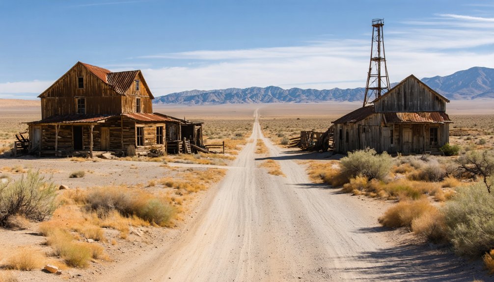
Reading the Ruins: Identifying Key Structures in Aerial Footage
Desolate patterns speak volumes when viewing ghost towns from above, revealing hidden stories through their skeletal remains. You’ll recognize residential clusters by their uniform rectangular foundations, while larger solitary footprints mark community hubs like saloons or schools.
Mining infrastructure tells tales of industrial ambition—ball mills appear as distinctive circular impressions, ventilation shafts as vertical openings punctuating the landscape. Through structural analysis, you can distinguish processing buildings by their elongated forms and heavy machinery footprints. In Simon, Nevada, you might spot the telltale outline of a flotation mill that once processed silver-bearing lead and zinc ore. The clever use of corrugated cardboard for insulation in harsh mountain climates can be identified by the distinctive rectangular cabin outlines with attached work sheds.
Decay patterns offer critical clues; collapse configurations reveal whether structures were wooden frames or masonry.
Look for environmental context too—towns positioned along hillsides often followed ore veins, while vegetation anomalies expose buried foundations invisible at ground level. Water infrastructure ruins and tramway remnants complete your aerial reading of these freedom-seeking pioneers’ abandoned dreams.
Desert Preservation: How Geography Protects These Historical Sites
Nevada’s harsh desert environment serves as nature’s perfect preservationist, safeguarding ghost towns in a state of suspended animation that you’d rarely find elsewhere. The arid climate prevents the moisture-driven decay that quickly consumes abandoned structures in wetter regions, creating an “arrested decay” that maintains the visual story of these settlements for centuries.
Geographic isolation works in tandem with these environmental factors, keeping the remnants of boom-town ambitions beyond the reach of urban sprawl and casual vandalism.
You’ll notice how the vast, undeveloped landscape creates natural buffers that limit foot traffic and development pressure. The Comstock Lode discovery in 1859 triggered the establishment of many of these settlements that now stand as weathered monuments to America’s mining history. The desert substrate itself contributes to this preservation, providing stable foundations without the destructive freeze-thaw cycles that collapse structures in other climates. Many sites like Rhyolite and Rawhide showcase the dramatic aftermath of fires that contributed to their eventual abandonment yet left behind tangible historical evidence.
Finding and Using Aerial Ghost Town Resources for Research
The fascinating quest to document Nevada’s ghost towns takes on entirely new dimensions when viewed from above.
You’ll discover unparalleled research opportunities when combining aerial mapping resources with historical archives.
Start by accessing USGS topographic maps through Google Earth, then overlay them with Nevada Bureau of Mines and Geology data for precise identification of abandoned settlements.
Cross-reference these findings with satellite imagery or drone photography to assess current site conditions.
For deeper historical context, pair your aerial research with mining records from geological surveys and historical photographs.
Websites like UnitedStatesGhostTowns.com offer specialized aerial views of Nevada’s mining remnants, while interactive ghost town maps provide GPS coordinates for over 800 sites.
Remember to check ownership status before visiting—many compelling locations like Nelson require permission for physical access, though their aerial views remain freely accessible.
The MRDS (Mineral Resource Data System) provides thousands of mine site records that can reveal hidden ghost towns not visible in standard satellite imagery.
These aerial surveys capture the remnants of Nevada’s gold rush era that once brought thousands of prospectors to the state, leaving behind the 600+ ghost towns we study today.
Frequently Asked Questions
Are Permits Required for Flying Drones Over Nevada Ghost Towns?
You’ll need permits if the ghost town’s in a state park—imagine bureaucracy haunting these ruins! For most ghost towns on BLM land, drone regulations are lighter, though filming restrictions still apply depending on location.
How Are Ghost Towns Distinguished From Active Mining Sites?
You’ll recognize ghost town characteristics by decaying structures, absent activity, and nature’s reclamation, while active mining site operations show modern equipment, personnel movement, and maintained infrastructure from your aerial perspective.
As you explore the landscape, you may come across abandoned military installations in Texas that tell a story of a bygone era. These sites, often shrouded in mystery, hint at the strategic importance they once held, now standing as silent observers of time. With the encroachment of local flora, they create a hauntingly beautiful juxtaposition against the harsh terrain of the Texas plains.
Can Aerial Footage Reveal Undiscovered Artifacts or Structures?
Yes. At the Techatticup mine, drone technology captured hidden foundations invisible from ground level. You’ll find artifact discovery’s potential soars with high-altitude perspective, revealing compositional patterns that free explorers from traditional search limitations.
What Seasonal Timing Produces the Best Aerial Ghost Town Photography?
Late fall offers your best aerial opportunities, blending autumn colors with crisp air quality. Winter landscapes reveal hidden structures through long shadows, giving your high-altitude perspective dramatic compositional depth and unrivaled clarity.
How Have Ghost Towns Changed Over Decades of Aerial Documentation?
90% of Nevada’s ghost towns show significant aerial evolution since the 1950s. You’ll notice collapsed wooden structures, eroded foundations, and altered landscapes that enhance their historical significance while revealing nature’s reclamation of human endeavors.
References
- https://www.shutterstock.com/image-photo/aerial-view-abandoned-ruins-rhyolite-mining-2064363434
- https://www.youtube.com/watch?v=6QlmbtQBCx4
- https://stock.adobe.com/search?k=nevada+mining
- https://pubs.nbmg.unr.edu/category-s/1945.htm
- https://travelnevada.com/ghost-town/ghost-towns-near-las-vegas/
- https://travelnevada.com/ghost-town/
- https://www.idyllicpursuit.com/13-hidden-ghost-towns-scattered-across-nevadas-desert/
- https://www.youtube.com/watch?v=xPLVDanhd3I
- https://www.youtube.com/watch?v=YgeIdSf5xSY
- https://www.youtube.com/watch?v=1qFxO2KKUl8