You’ll find Kalakaket’s haunting remains along Alaska’s Koyukuk River, where a once-vibrant Native Alaskan settlement thrived in the early 1900s. The community, known as ‘Aalaakkaakk’et’ in the native tongue, emerged from seasonal camps after St. John’s Episcopal Mission arrived in 1906. Devastating floods in 1930 and 1994, plus a 1920s epidemic, gradually emptied this historic crossroads where Koyukon Athabascans and Iñupiaq Eskimos once traded. The site’s preserved artifacts tell an deeper story of frontier resilience and cultural transformation.
Key Takeaways
- Kalakaket transformed from a thriving early 1900s settlement to a ghost town following devastating floods in 1930 and 1994.
- The community’s population severely declined from its peak during the woodcutting economy era to just 166 residents by 2025.
- Natural disasters, including ice jams and permafrost-related damage, forced many residents to abandon their traditional homesteads.
- The site preserves significant archaeological evidence of Alaska’s fur trade era and Indigenous cultural practices.
- Economic pressures and isolation led to the community’s transformation from a resource-based economy to primarily subsistence living.
Origins of Kalakaket Settlement
While closely linked to the neighboring settlement of Allakaket, Kalakaket emerged as a distinct community along the Koyukuk River in Alaska’s interior during the early 1900s.
You’ll find its roots deeply embedded in ancient pathways where Koyukon Athabascans and Iñupiaq Eskimos converged for hunting, fishing, and trapping.
The area’s Native name, ‘Aalaakkaakk’et,’ meaning ‘mouth of the Alatna River,’ marks this crucial cultural intersection where multiple indigenous groups traditionally gathered.
The establishment of St. John’s Episcopal Mission in 1906 transformed seasonal camps into a permanent settlement, drawing 15-20 families.
Despite devastating floods in 1930 and 1994 that forced relocation upriver, and a 1920s disease epidemic that claimed three-quarters of the population, the community maintained its cultural traditions through potlatches and subsistence practices.
The community’s location on the Arctic Circle in Alaska provided unique challenges and opportunities for maintaining traditional ways of life.
The region experiences extreme temperature variations, with record temperatures ranging from -75°F to 94°F.
Native Alaskan Life Along the Yukon
Native Alaskans along the Yukon River established an intricate subsistence pattern centered on hunting caribou, gathering berries, and fishing for salmon across seasonal cycles.
You’ll find evidence of their sophisticated trade networks that stretched from the coast to the interior, with communities exchanging seal oil, fur pelts, and food stores using the river as their primary transportation route.
During summer months, you’d see families following traditional migration paths to fish camps along the river’s edge, while winter brought them to sheltered camps where they’d rely on preserved foods and continued hunting. These Indigenous communities developed under the guidance of shamans as spiritual leaders, maintaining deep connections to their ancestral lands through traditional beliefs and practices. The Stickdance ceremony rotates between villages annually, helping communities process grief while honoring those who have passed on.
Traditional Subsistence Methods
Along the Yukon River, traditional subsistence methods formed the bedrock of Native Alaskan survival, with fishing and food preservation techniques passed down through generations.
These subsistence practices weren’t just about survival – they were deeply woven into cultural identity, shaping daily life and community bonds. At fish camps, elders taught spiritual salmon teachings as part of their essential cultural education.
You’ll find these critical elements at the heart of Yukon River life:
- Family-based fish camps where men hunted and fished while women and children processed the catch.
- Strategic preservation methods including smoking, drying, and fermenting fish to guarantee winter survival.
- Communal sharing systems that distributed large catches throughout the community.
The seasonal rhythm of salmon runs dictated life along the river, with summer harvests determining winter survival. Traditional fishermen used the seine technique to efficiently catch salmon by strategically placing nets in the river currents.
You’d see entire families working together, preserving fish on drying racks while elders passed down their ancestral knowledge.
River Trade Networks
Through intricate networks spanning thousands of miles, Indigenous groups along the Yukon River developed sophisticated trade systems that connected coastal Tlingit merchants to inland populations like the Hän, Tutchone, and Tanana peoples.
These trade dynamics revolved around large-scale expeditions organized by Tlingit leaders, who’d travel in caravans through crucial junctions like Kluane Lake and Fort Selkirk.
You’d find complex indigenous commerce patterns where coastal groups exchanged maritime goods and European items with interior communities, often using family members and slaves as porters. The Tlingit traded valuable goods including seaweed and seaweed cakes, dried clams, fish oil, and various medicinal herbs with inland groups. The Hudson’s Bay Company established trading posts along these ancient routes, capitalizing on existing Indigenous trade networks.
Seasonal Migration Patterns
Seasonal rhythms of wildlife migrations shaped daily life for Indigenous communities inhabiting the Yukon River corridor. Fish behavior, particularly the movement of salmon and burbot, dictated traditional subsistence patterns. The climate impact has begun disrupting these age-old cycles, affecting both wildlife and native practices. Mismatches between species and their food sources occur as warmer spring conditions alter traditional migration timing.
Key migration patterns you’ll find along the Yukon include:
- Juvenile Inconnu traveling 1,600-1,700 km downstream at 30-40 km daily
- Burbot spawning movements from October through February
- Black brant geese shifting their wintering grounds northward to Alaska from Baja
You’ll notice these changes most dramatically in how they affect native hunting and fishing practices. Higher July temperatures are condensing salmon migration windows, while unpredictable ice conditions challenge traditional burbot fishing methods that once sustained Yukon River communities. Modern tracking data shows that 42 percent of brant now overwinter in Alaska rather than migrating to their traditional grounds in Baja.
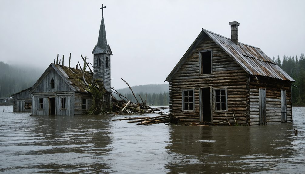
Natural Disasters and Environmental Challenges
If you’ve studied the Kalakaket region’s history, you’ll find that ice jams and flooding posed severe challenges for settlements along the river, as demonstrated by the devastating 1964 floods that inundated 85% of nearby Allakaket.
The area’s permafrost terrain created additional hazards, with seasonal thawing causing ground instability and structural damage to buildings.
These environmental pressures, combined with the regular spring breakup of river ice, made maintaining permanent settlements particularly challenging for both native and non-native communities in the area.
Ice Jams and Flooding
Located along the Koyukuk River, Kalakaket faced persistent challenges from ice jams and flooding that ultimately contributed to its abandonment.
Historical records reveal a devastating pattern of ice jam impacts, with major events in 1937, 1938, and 1939 causing repetitive damage to the settlement’s infrastructure.
You’ll find that the area’s flooding history includes three distinct threats:
- Spring breakup ice jams that created destructive backwater flooding
- Late summer rainfall events, like the catastrophic 1994 flood
- Combined events where ice jams coincided with rapid snowmelt
The flooding situation wasn’t just about water – it was about survival.
When ice jams formed at river constrictions, they’d create unpredictable and powerful floods that could exceed normal flood levels, making life in Kalakaket increasingly precarious for its residents.
Permafrost Settlement Issues
Underlying the challenges faced by Kalakaket’s residents, permafrost degradation posed a severe threat to the settlement’s stability.
You’ll find that as ground temperatures rose from -6°C to -3°C over recent decades, the thawing consequences became increasingly severe. The permanently frozen soil that once provided a stable foundation began to lose its strength, creating unstable ground conditions that threatened buildings and essential infrastructure.
This permafrost instability disrupted the region’s natural water patterns, forming liquid water layers beneath the surface that led to uneven ground subsidence.
When combined with increased flooding and erosion, you’d see how these conditions forced many residents to abandon their traditional homesteads. The thawing permafrost didn’t just damage structures – it transformed the entire landscape, affecting water quality and the fish habitats that local communities relied upon.
The Great Flood of 1964
During the catastrophic Great Alaska Earthquake of 1964, measuring between 8.4 and 9.2 in magnitude, Kalakaket and surrounding coastal communities faced unprecedented destruction from massive flooding and seismic sea waves.
The flood impacts and tsunami effects devastated the region with waves reaching heights of 20-30 feet, while tectonic subsidence caused the land to sink up to 5.6 feet.
You’ll find the destruction was intensified by three major factors:
- Liquefaction of saturated ground that weakened soils
- Multiple submarine landslides triggering local tsunamis
- Rising tides enhanced by land subsidence
The disaster claimed at least 18 lives in the Kodiak area while destroying essential infrastructure including ports, docks, and fishing vessels.
The flooding displaced residents and crippled the local fishing industry, leading to economic devastation that would forever change these coastal communities.
Economic Shifts and Population Decline
Beyond the physical destruction of the 1964 disaster, Allakaket faced mounting economic pressures that reshaped its community structure.
You’ll find a stark transformation from the early 1900s, when steamers paid $8 per cord for riverside woodcutting, to today’s limited commercial activities of gravel sales and indigenous craftwork.
Despite the community’s resilience, you can see how isolation and transportation barriers have stifled economic adaptation. With no road access to Alaska’s major hubs and high shipping costs, businesses struggle to establish themselves.
The population’s declined to 166 residents by 2025, while the median household income remains at $24,688.
Though potential exists in internet cafés and e-commerce, the town’s economic foundation has weakened since the 1990s closure of regional mines, shifting from resource extraction to government support and subsistence living.
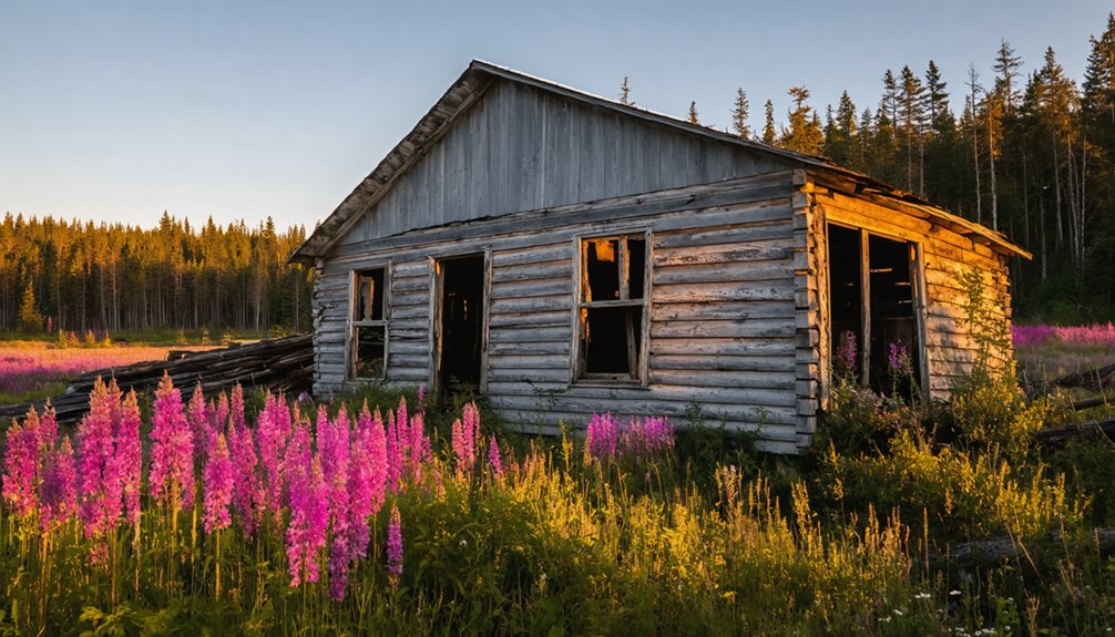
Abandonment and Ghost Town Status
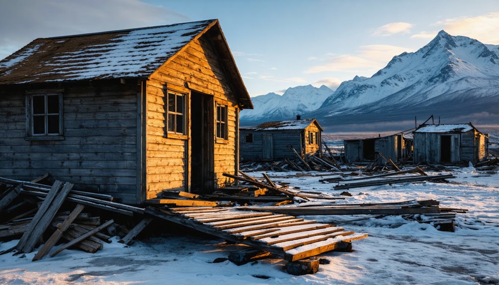
You’ll find that Kalakaket’s transformation into a ghost town came after severe ice jamming floods inundated the settlement, forcing residents to seek higher ground and safer locations.
The persistent flooding patterns, coupled with harsh weather conditions, accelerated the decay of the remaining structures until only scattered remnants marked where the community once stood.
Like many abandoned Alaskan villages, nature gradually reclaimed the site, with the original settlement’s footprint now barely visible among the encroaching wilderness.
Environmental Forces Behind Decline
While multiple Alaskan communities face environmental challenges, Kalakaket’s decline stems primarily from severe flooding events along the Koyukuk River and accelerating permafrost thaw. Climate change has intensified these environmental hazards, making the area increasingly uninhabitable.
The devastating impacts include:
- Repeated flooding since the 1930s, culminating in the destructive 1994 flood that destroyed 17 homes and severely damaged 24 others.
- Thawing permafrost that’s undermined soil stability, creating dangerous 12-14 foot vertical banks along 200 yards of riverfront.
- Contamination risks from abandoned infrastructure like the old gasoline tank farm.
You’ll find these compounding challenges have forced residents to relocate to higher ground, leaving behind a ghost town that continues to erode and decay as Arctic temperatures rise and storms intensify.
Population Migration Patterns
The environmental devastation of Kalakaket mirrors a broader pattern of population displacement across Alaskan settlements.
You’ll find this cultural migration follows typical boom-and-bust cycles, where communities rapidly formed around resource discoveries, only to dissipate when those resources depleted. Economic factors drove both the influx and exodus of residents, with families often following job opportunities or essential services.
As infrastructure declined and schools closed, you’d see a domino effect of departures, particularly among families with children.
The lack of basic amenities like electricity and running water, combined with the region’s remoteness, accelerated the town’s abandonment. While some resilient residents initially stayed behind as caretakers, the gradual erosion of government services and community support ultimately led to Kalakaket’s ghost town status.
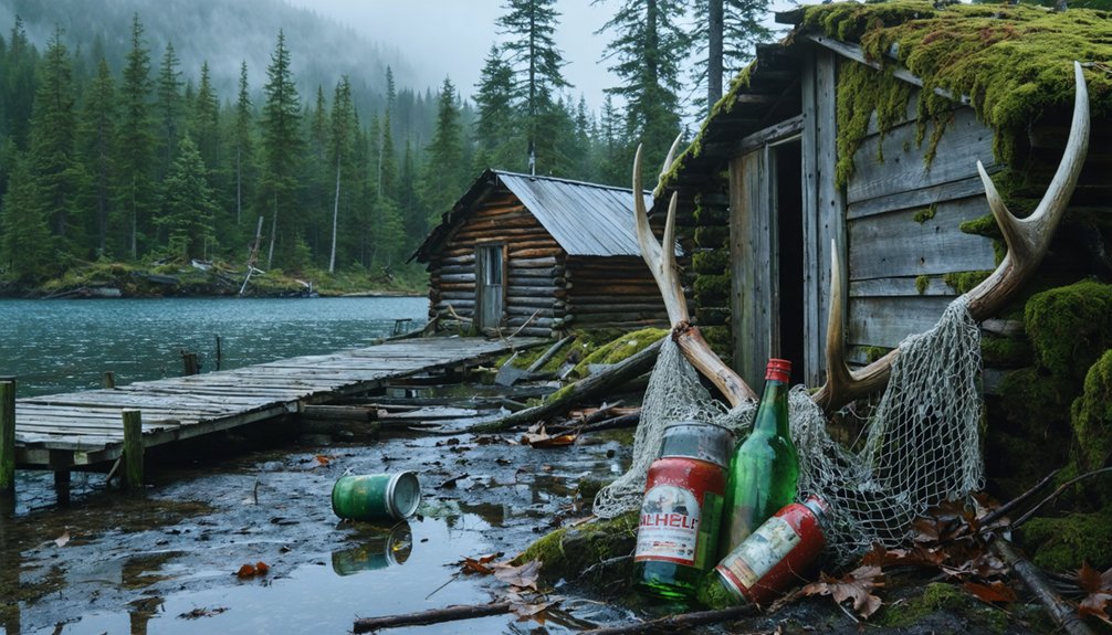
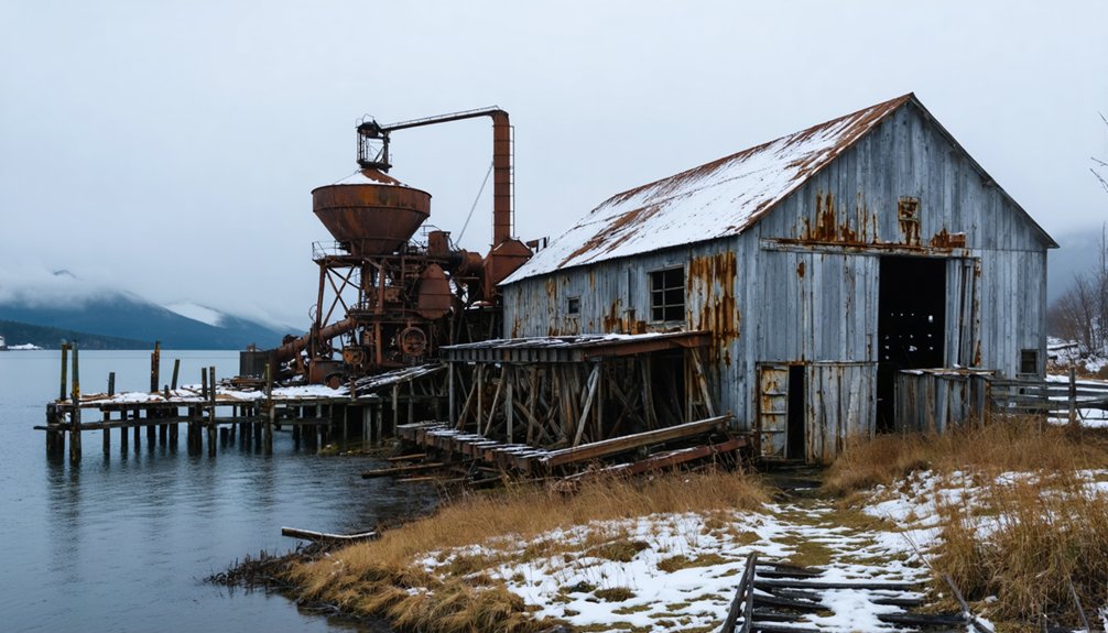
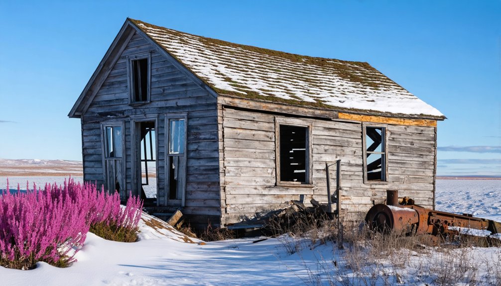
Remnants Of Former Settlement
Four distinct types of remnants characterize Kalakaket’s ghost town status today, ranging from partially intact structures to mere ground depressions.
You’ll find archaeological findings scattered across the site, where harsh Alaskan weather has accelerated the decay of wooden buildings and metal equipment.
The site’s key features include:
- Roofless ruins and rubble from collapsed structures
- Historical artifacts preserved by the region’s isolation
- Ground depressions marking former building locations
Nature’s reclamation of Kalakaket continues as flooding and erosion threaten the remaining physical evidence of human settlement.
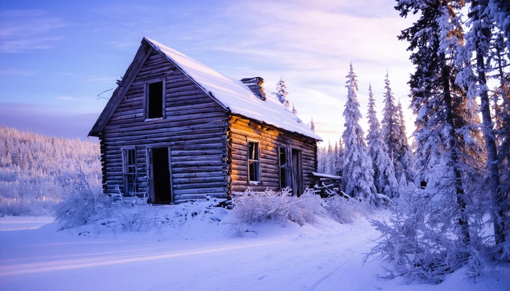
While some structures still stand, they’re rapidly deteriorating due to environmental exposure.
Like many Alaskan ghost towns, Kalakaket’s remnants tell the story of boom-and-bust cycles that shaped the state’s settlement patterns.
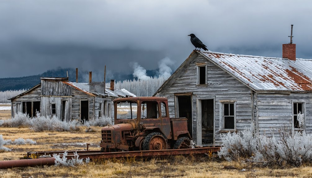
Remnants and Structures Today
Present-day remnants of Kalakaket remain largely undocumented in historical records, making it one of Alaska’s more enigmatic ghost towns.
Unlike well-known sites such as Kennecott, Kalakaket’s historical significance and current structural condition aren’t clearly detailed in available sources.
You’ll find that Alaska’s harsh climate poses significant challenges to any remaining structures.
Melting permafrost, extreme weather, and seismic activity typically accelerate structural deterioration in ghost towns throughout the region.
While some Alaskan ghost towns have benefited from preservation efforts and tourism revenue, Kalakaket’s remote location and limited documentation suggest it’s likely succumbing to natural reclamation.
Without proper maintenance or documented preservation initiatives, any surviving structures would face the same environmental pressures that have claimed many other abandoned Alaskan settlements.
Cultural Heritage and Historical Significance
Located at the confluence of the Alatna and Koyukuk rivers, Kalakaket’s cultural heritage weaves together Koyukon Athabascan traditions with Alaska’s gold rush era.
You’ll find a rich tapestry of cultural exchange between Indigenous peoples and frontier prospectors, showcasing the region’s dynamic history of economic interdependence.
This historic settlement exemplifies three key aspects of Alaska’s heritage:
- Traditional Koyukon place names and oral histories that preserve Indigenous knowledge
- Gold rush artifacts that tell stories of frontier entrepreneurship and mineral exploration
- Physical evidence of early cultural contact between Native peoples and miners
The town’s legacy lives on as a representation of Alaska’s pioneering spirit, where traditional subsistence patterns merged with frontier capitalism, creating unique social dynamics that shaped the Yukon-Koyukuk region’s development.
Neighboring Communities and Regional Impact
The network of communities surrounding Kalakaket tells a complex story of regional interdependence and adaptation. You’ll find Allakaket and Alatna at the heart of this region, positioned where the Alatna and Koyukuk Rivers meet near the Arctic Circle.
These villages showcase remarkable environmental resilience, having faced devastating floods that forced relocations and rebuilding efforts, particularly after 1994.
Despite nature’s fierce challenges, these resilient villages have rebuilt and adapted, proving their strength following the devastating 1994 floods.
The area’s cultural exchange flows through a web of neighboring settlements including Hughes, Huslia, and Nulato, where primarily Alaska Native populations maintain traditional subsistence lifestyles.
You’ll notice how population shifts between these communities reflect their deep connection to the land, as residents adapt to environmental challenges while preserving their hunting, fishing, and trapping traditions across the challenging Arctic terrain.
Preservation Efforts and Archaeological Value
Since its abandonment, Kalakaket’s historical legacy has garnered significant attention from preservationists and archaeologists who recognize its unique value in documenting Alaska’s fur trade era and Indigenous cultural shifts.
Despite the site’s archaeological significance, you’ll find preservation challenges stemming from its remote location and harsh climate conditions.
Three key aspects of Kalakaket’s preservation efforts include:
- State heritage laws protecting cultural resources from looting
- Collaborative monitoring between Indigenous groups and agencies
- Documentation projects by government institutions
The site’s well-preserved organic materials and artifacts provide vital insights into early settlement patterns and trade networks.
You’ll discover that ongoing preservation work integrates Indigenous knowledge with modern archaeological techniques, though funding limitations and complex land ownership issues continue to impact conservation efforts.
Frequently Asked Questions
Are There Any Seasonal Tours or Guided Visits Available to Kalakaket?
You won’t find official seasonal tours or guided visits to Kalakaket. Unlike other Alaskan ghost towns that offer regular tours, there’s no documented tourism infrastructure or organized tour services at this location.
What Wildlife Species Currently Inhabit the Abandoned Kalakaket Settlement Area?
You’ll spot diverse wildlife including caribou, moose, brown bears, wolves, and arctic foxes, plus various bird species like northern shrikes and red-tailed hawks during wildlife observation around the abandoned structures.
Can Visitors Legally Collect Artifacts From the Kalakaket Ghost Town Site?
Like a precious time capsule that must remain sealed, you can’t legally collect artifacts here. Federal and state legal regulations protect historical sites, requiring permits for any artifact preservation or removal.
Does Anyone Maintain Land Ownership Claims in Present-Day Kalakaket?
You’ll find no confirmed active land ownership claims in the area today, though property disputes could arise between federal agencies and any undocumented private claims due to historical abandonment.
What Is the Best Time of Year to Access Kalakaket?
Like a salmon’s perfect upstream window, you’ll find the best weather and seasonal accessibility from late June through early September, when melting snow and extended daylight make exploration safest.
References
- https://www.thealaskalife.com/blogs/news/alaska-ghost-towns-youve-probably-never-heard-of
- https://www.youtube.com/watch?v=Cz0IGc2Uy0E
- https://www.nps.gov/parkhistory/online_books/yuch/golden_places/chap11.htm
- https://www.youtube.com/watch?v=GNjMpM6b58o
- https://www.gi.alaska.edu/alaska-science-forum/ghost-towns-scattered-across-alaska-map
- https://en.wikipedia.org/wiki/List_of_ghost_towns_in_Alaska
- https://en.wikipedia.org/wiki/Allakaket
- https://www.tananachiefs.org/about/communities/allakaket/
- https://pubs.aina.ucalgary.ca/arctic/Arctic42-2-148.pdf
- https://www.achill.life/where-we-areallakaket