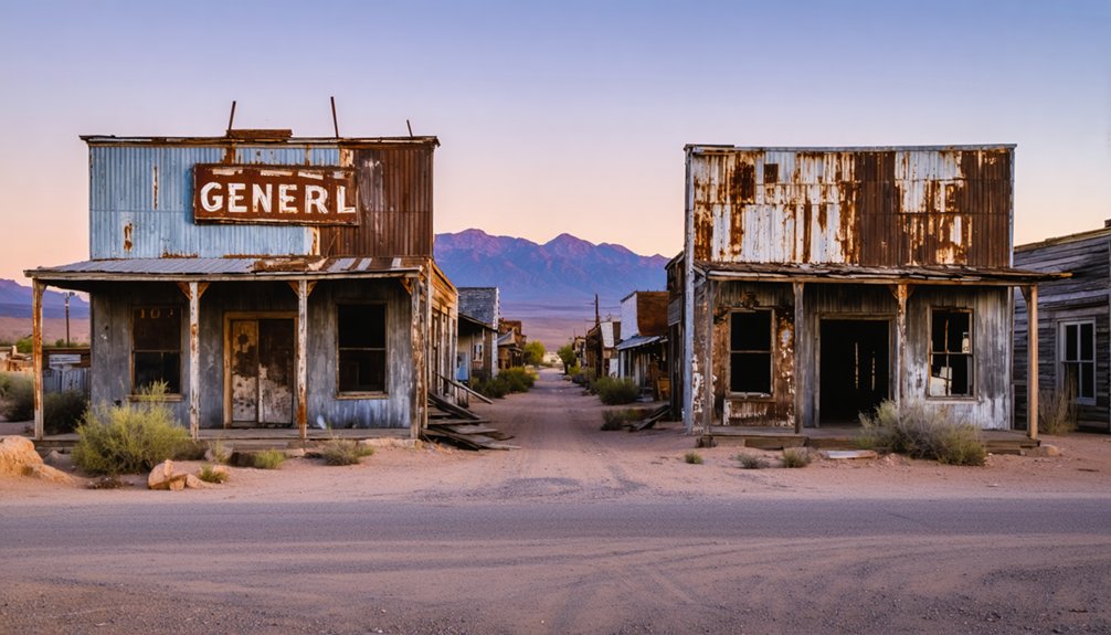
You’ll discover Alamo Crossing as a submerged ghost town in Mohave County, Arizona, established in 1899 by Tom Rogers during the region’s mining boom. The settlement, which never exceeded 25 residents, operated a five-stamp mill and post office until 1918, serving prospectors seeking placer gold and manganese. Since 1968, this former mining hub has rested beneath Alamo Lake’s waters, where its preserved structures and archaeological sites hold countless frontier stories waiting to be explored.
Key Takeaways
- Alamo Crossing was a mining settlement founded in 1899 in Mohave County, Arizona, reaching a peak population of 25 during its existence.
- The town featured a five-stamp mill and post office until 1911, primarily serving gold prospectors and manganese mining operations.
- The settlement was abandoned in 1918 as mining yields declined, marking the end of its brief history as an active community.
- Since 1968, Alamo Crossing has been submerged beneath Alamo Lake, preserving its original structures and archaeological sites underwater.
- Visitors can explore the submerged ghost town through diving, with depths up to 80 feet revealing preserved foundations and mining-era relics.
The Birth of a Desert Mining Town
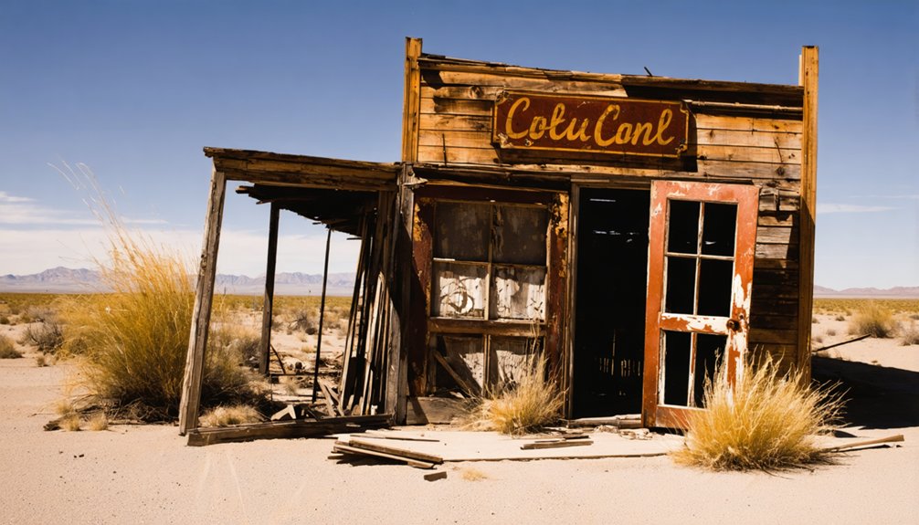
When Tom Rogers established Alamo Crossing in 1899, he laid the foundation for what would become a modest yet significant mining settlement in Mohave County, Arizona. At an elevation of 1,237 feet, this desert outpost attracted prospectors seeking their fortunes in the Artillery Mountains range, where placer gold beckoned those willing to test their desert survival skills. The town never grew beyond a peak population of 25 during its existence.
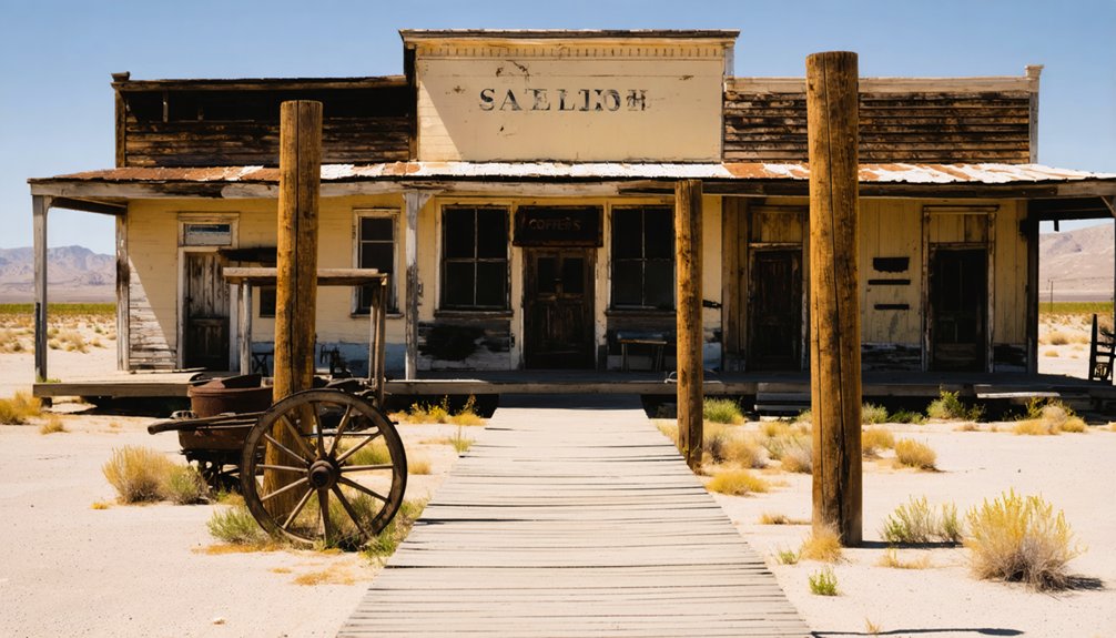
You’ll find that the town’s early infrastructure reflected the era’s mining technology, centered around a five-stamp mill for processing ore. The establishment of a post office in 1889, along with several general stores, provided essential services to the transient mining population. The post office remained operational until March 30, 1911, marking the end of an era for this desert community.
Rather than developing into a permanent settlement with substantial structures, Alamo Crossing maintained its character as a prospector’s camp, where miners preferred temporary accommodations to permanent residences.
Life Along the Bill Williams River
You’ll find evidence of extensive Native American settlement patterns along the Bill Williams River, where tribes relied on the year-round flows and rich riparian woodlands for sustenance and trade.
The river’s consistent water supply from the Big Sandy and Santa Maria tributaries created favorable conditions for both indigenous communities and early settlers to establish trading activities despite the harsh desert environment. The area’s elevation of 453 feet at its mouth made it accessible for settlements along its banks.
While seasonal fluctuations presented water management challenges, the river’s extensive cottonwood-willow forests provided essential resources and natural corridors for commerce and cultural exchange. The area’s diverse ecosystem supported over 350 bird species, making it a vital habitat for wildlife and human settlements alike.
River Trading Activities
Throughout the late 1800s and early 1900s, the Bill Williams River served as an essential commercial artery for western Arizona’s burgeoning settlements and industries.
Named after the legendary Bill Williams the mountaineer, this vital waterway played a crucial role in the region’s development. The river’s namesake was known for his work as a master interpreter, helping facilitate communication between settlers and Native American tribes. You’d find traders moving agricultural products, livestock, and mining supplies along this significant waterway, with Alamo Crossing emerging as one of the region’s busiest trading hubs. River transport relied on flat-bottomed boats and rafts, while pack animals carried goods to and from strategic river landings.
The river’s seasonal patterns dictated the flow of commerce, with traders adapting their schedules to accommodate flooding and drought conditions.
You could spot boats laden with cotton, alfalfa, and citrus, while manufactured goods and mining equipment made their way upstream. This dynamic exchange supported local economies until the advent of railroads and highways eventually transformed the region’s commercial landscape.
Native Settlement Patterns
Along the meandering Bill Williams River, native settlements flourished in strategic locations that maximized access to essential resources while minimizing environmental risks.
These communities established themselves on stable alluvial terraces, adapting their cultural practices to the rhythms of the river and surrounding riverine habitats. The Bill Williams Settlement Act formalized historic water rights for these indigenous communities in 2014. The recent Hualapai Settlement Act further protected ancestral water access rights in the region.
- You’ll find evidence of settlements carefully positioned to avoid seasonal flooding while maintaining direct access to water and fertile soil.
- Communities developed specialized knowledge of fishing, hunting, and plant harvesting techniques unique to the river ecosystem.
- Villages featured structures built from local materials like river wood and reeds, organized around communal spaces.
- Settlement layouts reflected both practical needs and spiritual connections, with ceremonial areas situated near the life-giving waters.
Seasonal Water Challenges
Life along the Bill Williams River presented intricate seasonal water challenges, as the region’s complex hydroclimatologic patterns alternated between dry winters and intense summer monsoons.
You’ll find that seasonal droughts and erratic precipitation, ranging from 45 cm in headwaters to just 12.1 cm near the Colorado River, made water management essential for survival.
The construction of Alamo Dam in 1969 fundamentally altered the river’s natural rhythms.
While you’d traditionally experience brief but powerful summer storms and moderate winter rains, the dam’s operations created extreme conditions beyond natural variability.
These changes profoundly impacted the ecosystem, forcing wildlife to adapt through reduced metabolic rates and altered habitat usage.
The riparian corridor’s native species, particularly cottonwood and willow forests, struggled to maintain their foothold against invasive tamarisk during prolonged dry spells.
Mining Operations and Economic Impact
While Alamo Crossing‘s establishment primarily served prospectors in the manganese-rich Artillery Mountains, its mining operations encompassed a broader spectrum of mineral extraction activities. The area’s strategic location made it an important hub for early settlers seeking mining opportunities.
The town’s economic fluctuations directly correlated with various mining techniques and market demands, particularly during the 1950s boom when the Oversight mine yielded over 1,000 tons of ore. After the town was abandoned in 1918, the post office and mill stood in ruins for five decades.
You’ll find these notable aspects of Alamo Crossing’s mining legacy:
- A five-stamp mill supported extensive manganese extraction operations
- The Rodgers brothers controlled multiple profitable mining claims
- Peak production occurred between 1952-1954 at the Mesa Manganese claim
- The 2020 gold exploration by Power Metal Resources sparked renewed interest
The town’s prosperity ebbed and flowed with mineral demand, ultimately leading to its submersion beneath Alamo Lake in 1968, though remnants of its mining heritage persist underwater.
Daily Life in the Early Settlement
Despite its role as a mineral extraction hub, Alamo Crossing maintained a remarkably sparse and transient population throughout its existence. Your daily routines would have centered primarily on mining activities, with most residents living in temporary shelters and tents rather than permanent structures.
You’d have found no schools, churches, or organized community events to break up the monotony of frontier life.
Survival strategies focused on securing basic necessities. You’d have relied on the local store for supplies, though provisions were limited. With no agriculture and uncertain water sources, you would’ve depended on imported goods and possibly hunting.
Life hinged on the local store’s meager supplies, forcing residents to depend heavily on imported goods and occasional hunting.
The harsh conditions and isolation meant you’d need to be self-sufficient, as law enforcement was nonexistent and safety depended entirely on informal arrangements among the miners themselves.
The Rise and Fall of Commerce
The commercial landscape of Alamo Crossing emerged in 1899 when Tom Rogers established the settlement as a mineral extraction hub near the Artillery Mountains.
You’ll find the town’s economic story defined by mining techniques centered around a five-stamp mill, serving a population that never exceeded 25 residents.
Key aspects of Alamo Crossing’s commerce include:
- A post office operating intermittently from 1889 to 1918
- Basic stores supporting transient prospectors
- Mineral processing facilities for manganese extraction
- Limited infrastructure reflecting economic fluctuations
The town’s commercial decline accelerated as mining yields diminished in the early 1900s, leading to intermittent abandonment.
The final chapter came in 1968 when the creation of Alamo Lake submerged the settlement, transforming it from a ghost town into an underwater archaeological site.
Beneath Alamo Lake’s Waters
When you venture beneath Alamo Lake’s surface today, you’ll discover the remarkably preserved remains of Alamo Crossing, a once-bustling frontier town submerged by the lake’s creation in 1968.
The underwater site contains the town’s original structures, including a post office and mill, protected from surface deterioration by the lake’s waters.
This submerged settlement offers researchers and archaeologists valuable insights into Western frontier life, while presenting unique preservation challenges that require careful monitoring and protection efforts.
Hidden History Lies Below
Beneath the waters of Alamo Lake lies a rich archaeological legacy, documented through eleven distinct sites before the reservoir’s creation in 1968. The archaeological significance of these submerged artifacts offers insights into centuries of human activity, from prehistoric settlements to military presence in the 17th and 18th centuries.
- Dense clusters of ceramics and stone tools reveal patterns of early human settlements.
- Military artifacts, including gun parts, document historical occupation periods.
- Pre-impoundment surveys captured critical data before flooding.
- Fluctuating water levels occasionally expose hidden sites for brief study.
You’ll find the preservation state of these underwater treasures remains largely unknown, though ironically, submersion may protect some artifacts from surface erosion.
While thorough underwater archaeology hasn’t been conducted, the documented sites continue to intrigue researchers studying human-environment interactions in this unique desert setting.
Exploring the Sunken Settlement
Lying beneath Alamo Lake‘s tranquil waters, the remnants of a once-thriving mining settlement offer tantalizing glimpses into Arizona’s frontier past. If you’re interested in submerged archaeology, you’ll find the ghostly remains of Alamo Crossing resting 80 feet below the surface, where structures from this early 1900s community still stand frozen in time.
Before its submersion in 1968, this ghost town featured a five-stamp mill, post office, and various stores that served local prospectors seeking manganese in the Artillery Mountains.
Today, you can explore these underwater ruins through scuba diving, though specialized equipment is required. While systematic underwater archaeology remains limited, the site represents a unique preservation of frontier history, with historic houses and irrigation ditches offering evidence to the area’s mining and ranching heritage.
Preserving an Underwater Past
Since the creation of Alamo Lake in 1968, the preservation of its submerged archaeological treasures has presented unique challenges for cultural resource managers. The site’s archaeological significance extends beyond the sunken ghost town, encompassing lithic artifacts and evidence of indigenous habitation dating back to 5000 BC.
- Water level fluctuations expose cultural materials to weathering and potential vandalism.
- No historic preservation mandates existed during dam construction to protect submerged sites.
- Scattered artifacts include cores, flakes, and tools made from chalcedony, jasper, and chert.
- Cultural preservation efforts require continuous monitoring of exposed sites.
You’ll find the region’s rich heritage reflected in its archaeological record, from ancient Patayan settlements to 19th-century mining operations.
While submersion has helped preserve some artifacts, the challenges of managing underwater cultural resources demand ongoing vigilance and innovative preservation strategies.
Legacy of the Post Office Era
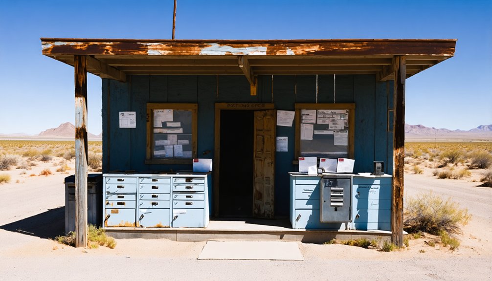
Although relatively short-lived, the Alamo Crossing post office‘s legacy endures as a proof of Arizona’s territorial development and the crucial role of postal services in frontier communities.
Operating in two distinct periods between 1889 and 1918, you’ll find that this post office served as more than just a mail facility – it became the backbone of community connections in a transient mining town.
The significance of this territorial-era institution extended beyond its basic postal functions, as it facilitated essential communication channels for miners, enabled commerce through supply orders, and provided a social anchor for scattered settlers.
Until its submersion beneath Alamo Lake, the building stood as one of Arizona’s oldest surviving territorial post office structures, symbolizing the pioneering spirit of western expansion.
Tales From the Artillery Mountains
The Artillery Mountains hold a rich tapestry of tales that interweave geological wealth with human ambition and frontier mythology.
Within these rugged geological formations, you’ll discover stories of prospectors who braved harsh conditions while employing various mining techniques to extract manganese from the region’s rich deposits.
- Local legends tell of a Native American raid on the settlement’s store, though historical records don’t support these dramatic claims.
- Mining camps dotted the 25-square-mile expanse between Artillery and Rawhide Mountains.
- The region’s richest manganese outcrops drew waves of hopeful miners to the foothills.
- Oral histories paint a picture of transient life, where prospectors followed promising veins.
The area’s true story isn’t one of conflict but rather the familiar boom-and-bust cycle of frontier mining towns, where resource depletion ultimately determined the settlement’s fate.
Modern Adventures and Exploration
Today you’ll find adventurous explorers using scuba equipment to investigate Alamo Crossing’s submerged remnants, where building foundations and mining equipment rest beneath Alamo Lake’s waters at depths reaching 80 feet.
While modern prospectors still search for placer gold deposits along the lake’s shores, they must obtain proper permits from the Bureau of Land Management before beginning their treasure hunts.
Your visit to this unique historical site might include camping at designated areas within Alamo Lake State Park, where you can experience both the area’s rich mining heritage and its recreational offerings.
Underwater Diving Adventures
Beneath Alamo Lake’s surface lies a fascinating underwater time capsule, where modern diving adventures offer an extraordinary glimpse into Arizona’s mining history.
You’ll discover the preserved remnants of a once-thriving mining community established in 1899, now submerged since 1968.
For the adventurous diver seeking freedom in exploration, Alamo Crossing presents:
- Depths reaching 80 feet with varying visibility for examining original building structures
- Year-round diving opportunities in temperatures from mid-50s to mid-80s Fahrenheit
- Self-guided exploration of mining equipment and architectural remains
- A more secluded experience compared to popular Lake Havasu or Lake Mohave
While dive safety and underwater navigation require advanced skills, you’ll experience an unparalleled journey through this submerged ghost town that uniquely preserves early 20th-century western settlement life.
Hidden Treasures Below
Since its submersion in 1968, Alamo Crossing’s underwater landscape has emerged as a treasure trove for modern adventurers and researchers alike.
You’ll find hidden artifacts preserved beneath Alamo Lake’s depths, including a well-preserved five-stamp mill and various mining-related structures that offer glimpses into 19th-century frontier life.
While you’ll need specialized scuba gear to explore these submerged relics, the site’s preservation under approximately 80 feet of water has created a unique time capsule.
The surrounding region continues to draw prospectors, with renewed mining activity since 2020 focusing on placer gold deposits near the Artillery Mountains.
Though you can’t access the original townsite by land, modern mineral detection technology has opened new opportunities for exploration in adjacent areas, maintaining the area’s historical significance as a mineral-rich destination.
Recreational Activities Today
Modern adventurers flock to Alamo Lake State Park for an array of recreational activities that blend historical exploration with outdoor pursuits.
You’ll discover unique opportunities to explore Arizona’s mining heritage while engaging in contemporary outdoor recreation across land and water.
- Dive up to 80 feet beneath the surface to explore preserved foundations and remnants of the old mining settlement.
- Experience recreational fishing for largemouth bass, crappie, and catfish while boating activities unfold above the submerged town.
- Trek desert trails offering wildlife viewing and vistas of the Bill Williams River and Artillery Mountains.
- Try your hand at placer gold prospecting in nearby stream beds and washes.
Whether you’re searching underwater ruins, casting a line, hiking scenic paths, or seeking gold, you’ll find adventure seamlessly woven with historical significance at every turn.
Preserving Arizona’s Submerged History
The preservation of Alamo Crossing presents unique challenges and opportunities for Arizona’s historical record, as its structures lie submerged beneath the waters of Alamo Lake.
You’ll find that traditional ghost town preservation methods don’t apply here, as the site requires specialized submerged archaeology techniques and scuba equipment to access.
While the lake environment helps slow decay of the town’s remains, including its five-stamp mill and stores, underwater exploration risks damaging these fragile structures.
Documentation efforts rely heavily on underwater photography and diving expeditions, yet there aren’t any permanent facilities or marked underwater trails for public access.
The site’s unique status makes it particularly valuable for historical research, offering insights into early 20th-century mining communities while requiring careful balance between preservation and exploration.
Frequently Asked Questions
Were There Any Notable Crimes or Murders in Alamo Crossing’s History?
While ghost sightings intrigue visitors, you won’t find unsolved mysteries here – historical records show no documented murders or notable crimes during the town’s existence from 1899 to its watery end.
What Native American Tribes Originally Inhabited the Area Around Alamo Crossing?
You’ll find the Hualapai, Western Yavapai, and Malchictmm tribes originally inhabited this land, following the ancient Hohokam culture. Native legends tell of peaceful coexistence among these peoples along the rivers.
How Deep Is the Water Above the Submerged Town Site?
You’ll find approximately 80 feet of water depth above this submerged history, requiring scuba gear to explore the well-preserved remnants of what was once a bustling mining community.
Did Any Famous Pioneers or Historical Figures Visit Alamo Crossing?
You won’t find records of any famous visitors at this site. Historical significance comes from its mining activities and underwater preservation, rather than visits from notable pioneers or historical figures.
What Happened to the Residents After the Town Was Abandoned?
You’ll find that the residents’ fate after the ghost town’s abandonment led them to scatter across nearby Arizona communities, while some original settlers stubbornly remained until the mid-1950s before final displacement.
as you delve into exploring alexandra ghost town history, you uncover tales of resilience and hardship faced by those who clung to the remnants of their past. Each crumbling structure tells a story, revealing insights into the lives of early settlers and their struggles in a harsh environment. This exploration not only highlights the impact of economic shifts but also enriches our understanding of Arizona’s broader historical narrative.
References
- https://www.destination4x4.com/alamo-crossing-mohave-county-ghost-town/
- https://kids.kiddle.co/Alamo_Crossing
- https://en.wikipedia.org/wiki/Alamo_Crossing
- https://www.youtube.com/watch?v=CpD1fx11YNw
- http://www.stagecoachtrailsranch.com/2017/10/01/alamo-lake-lost-submerged-ghost-town/
- https://www.azcentral.com/story/news/local/arizona-history/2025/04/02/7-uniquely-arizona-ghost-towns/81809788007/
- https://www.ghosttowns.com/states/az/alamocrossing.html
- https://www.onlyinyourstate.com/experiences/arizona/underwater-ghost-town-az
- https://www.arizonahighways.com/archive/issues/chapter/Doc.518.Chapter.3
- https://www.destination4x4.com/resources/ghost-towns/


