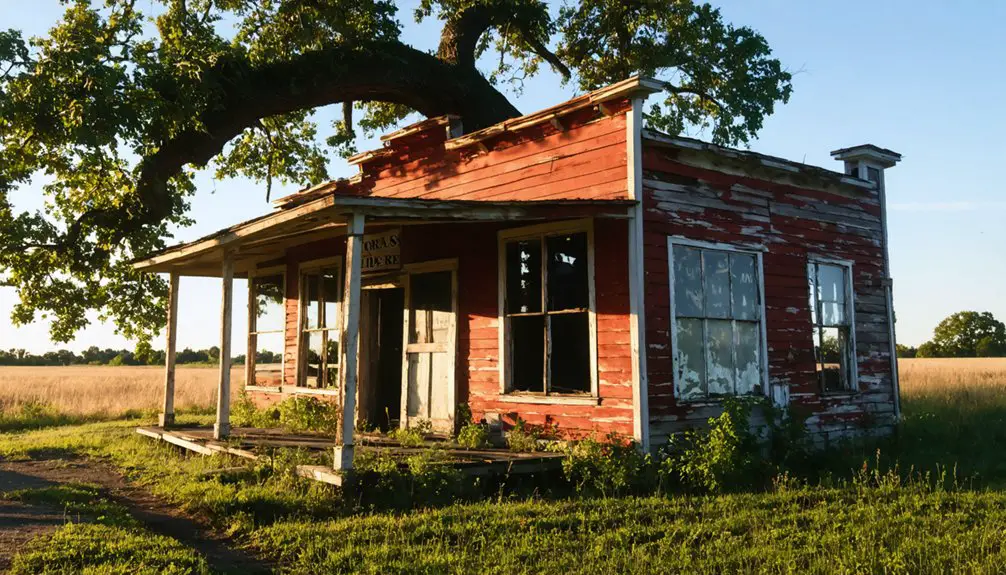
You’ll find Armerford nestled in Indiana County, Pennsylvania’s coal country at 40.48417°N, 78.92222°W. This former mining town emerged in the late 1800s amid the Allegheny Mountains near Black Lick Creek. Today, only five residents remain among scattered ruins, cracked streets, and metal venting tubes releasing underground fire gases. You can access this ghost town via the 36-mile Ghost Town Trail, where St. Mary’s Church stands as a reflection of its industrial past.
Key Takeaways
- Armerford was a coal mining company town in Indiana County, Pennsylvania, now largely abandoned with only five remaining residents.
- The town declined in the mid-1930s when mining operations ceased, leaving buildings stripped for lumber and mining infrastructure sold for scrap.
- St. Mary’s Church remains among cracked streets and overgrown sidewalks, with metal venting tubes releasing gases from underground fires.
- The Ghost Town Trail, a 36-mile recreational path, connects visitors to Armerford’s industrial heritage and mining history.
- Located at 40.48417°N, 78.92222°W in the Allegheny Mountains, Armerford features scattered ruins amid scorched terrain and new-growth forests.
Location and Geographic Setting
Nestled in Indiana County’s rugged terrain, Armerford stands as a tribute to Western Pennsylvania’s coal mining heritage.
Among Pennsylvania’s weathered hills, Armerford whispers tales of coal dust and the determined spirits who once called it home.
You’ll find this ghost town positioned at roughly 40.48417°N latitude and 78.92222°W longitude, where the Allegheny Mountains create a dramatic backdrop of steep valleys and forested ridges. The town’s location was strategically chosen along the former Ebensburg and Black Lick Railroad corridor, which paralleled vital local waterways like Black Lick Creek.
The geographic features that surround Armerford tell the story of its past. Dense forests have reclaimed much of the mountainous landscape, but you can still trace the natural transportation corridor that once made this settlement possible. Today, visitors can explore the area along the Ghost Town Trail, which was established in 1991. The trail spans 36 miles through the historic mining region.
The town’s placement within the valley offered both water resources and the fundamental rail access that sustained the community during its heyday.
The Rise of Coal Mining Operations
While Pennsylvania’s coal industry began with anthracite mining in the east, Armerford’s story parallels the rise of bituminous coal operations that transformed Western Pennsylvania in the late 1800s.
You’ll find that coal mining here followed the room-and-pillar technique, with miners using picks, shovels, and horse-drawn wagons to extract the valuable resource from drift mines cut into exposed seams. By 1830, coal consumption soared as Pittsburgh alone required over 400 tons of bituminous coal daily.
The economic impact was substantial, as mining towns like Armerford emerged to support growing company operations. The mining industry saw significant growth after the War of 1812 created increased demand for domestic coal production.
Much like the Clearfield Bituminous Coal Corporation‘s setup, these operations often served specific industrial clients, particularly the expanding railroad networks.
Life in a Company Mining Town
You’d find your daily life as a miner in Armerford strictly governed by the company’s schedule, with early morning shifts beginning before dawn and extending through grueling hours underground.
Your home would likely be a company-built duplex or row house, clustered tightly with other workers’ residences to maximize space near the mine entrance.
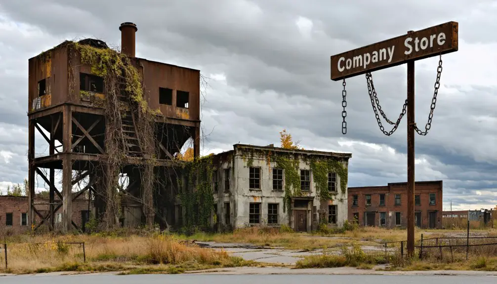
While basic amenities like sanitation systems were provided, you’d share the common experience of crowded living conditions with your fellow miners, all operating under the watchful eye of company management. Most necessities had to be purchased at the company store, creating a cycle of dependency on mine operators.
From 1870 to 1915, you might have worked alongside many of the European immigrants who came seeking employment in the anthracite mines.
Daily Worker Routines
As the sun crept over the horizon each morning, Armerford’s miners would already be trudging toward the mine entrance for their grueling 10- to 12-hour shifts underground.
You’d arrive before dawn, joining your fellow workers at the mine’s entrance for strict shift changes, where being late meant losing your day’s wages or worse.
Inside, you’d face the constant dangers of roof collapses, toxic gases, and equipment failures while cutting coal, setting support timbers, or hauling loads to the lifts.
During brief communal meals in designated areas, you’d share warnings about hazardous conditions and build essential bonds with your work team.
After your shift, you’d clean up at the wash basins before heading to the company store, where your scrip – not real cash – would buy your family’s necessities.
In the town’s heyday, workers would gather at one of the numerous saloons to unwind after their exhausting shifts.
Some miners participated in wild cat strikes over issues like car pushing requirements, risking both their jobs and safety to protest unfair working conditions.
Living Conditions and Housing
Despite their modest construction, Armerford’s company-built houses formed the backbone of daily life in the mining town.
You’d find yourself living in a wooden duplex, sharing a wall with your neighbor to maximize space in the company’s tightly planned village layout. While you’d have basic housing amenities like electricity and sewer connections, the company maintained strict community control over your living situation. Like many towns across Pennsylvania’s anthracite heartland, Armerford’s housing reflected the industrial might built by immigrant labor. Families supplemented their food needs with vegetable gardens and livestock.
Your rent would come directly from your paycheck, and you’d have little choice but to shop at the company store, where prices were typically inflated.
The town’s infrastructure included a two-story school, churches shared by multiple Protestant denominations, and community halls for social gatherings.
Though recreational facilities like baseball fields existed, they served as another way for the company to monitor and manage your daily activities.
Railroad’s Role in Development
When the Huntingdon and Broad Top Mountain Railroad established operations in Bedford County during the mid-19th century, it transformed Armerford into an indispensable transportation hub.
The railroad expansion connected the town to major markets, creating crucial links with the Pennsylvania Railroad’s extensive network and the Bedford and Bridgeport Railroad.
Railroad networks transformed Armerford into a vital crossroads, forging essential connections between major markets through Pennsylvania’s expanding rail system.
You’ll find that this economic transformation revolutionized local industry. Coal from nearby mines and iron from local furnaces could now reach distant markets in hours instead of days.
The H&BT’s strategic location along riverbanks and valleys made Armerford a natural transfer point, while repair facilities in nearby Saxton provided steady employment.
The town’s integration into the regional rail system brought unprecedented opportunities, as passenger services connected residents to larger economic centers and tourism destinations throughout Pennsylvania.
The Decline and Abandonment
The collapse of the coal industry in the early 20th century dealt a fatal blow to Armerford’s existence. As the Lackawanna Iron and Coal Company mines shut down in the 1920s and 1930s, you’d have witnessed devastating economic impacts ripple through the community.
Without mining jobs, families had no choice but to abandon their homes and seek opportunities elsewhere.
The community changes were swift and irreversible. By the mid-1930s, you wouldn’t have found more than empty buildings stripped for lumber and mining infrastructure sold for scrap.
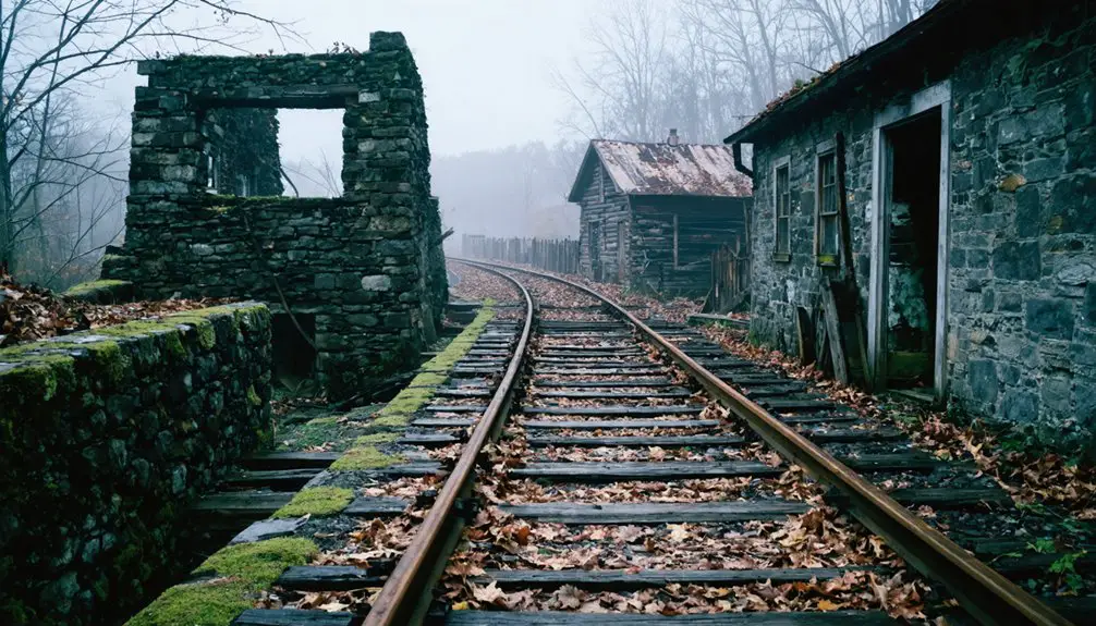
Unlike neighboring Wehrum, which still has visible ruins, Armerford’s physical remnants have largely vanished beneath forest growth.
Today, private property restrictions and minimal historical documentation make it challenging to preserve what little remains of this once-thriving mining town.
What Remains Today
Scattered among the scorched terrain and emerging new-growth forests, Armerford’s remaining structures tell a haunting story of abandonment and resilience.
A remnants analysis reveals only a handful of buildings, including St. Mary’s Church, standing amid cracked streets and overgrown sidewalks. You’ll notice metal venting tubes piercing the ground, releasing gases from the relentless underground fire that’s consumed nearly 3,700 acres.
The environmental impact is stark – plumes of smoke rise from the earth while nature slowly reclaims the town.
Though about five residents remain as holdouts, you won’t find this ghost town on most maps. The buried Graffiti Highway and rerouted Route 61 stand as evidence to the area’s hazardous conditions, while historical markers preserve memories of its mining heritage.
As you venture off the beaten path, exploring Washington’s ghost towns by ATV offers an exhilarating way to connect with the past. Each ride uncovers remnants of vibrant communities that once thrived in these now-desolate landscapes. The thrill of discovering hidden treasures makes every trip a unique adventure.
Legacy Along the Ghost Town Trail
Along the abandoned corridors of the Ebensburg and Black Lick Railroad, a remarkable 36-mile trail system now preserves the memory of Pennsylvania’s vanished mining communities.
As you traverse this National Recreation Trail, you’ll discover interpretive markers that breathe life into community memories of towns like Armerford, Wehrum, and Bracken.
The trail’s historical preservation efforts showcase the region’s industrial heritage through remnants like the Eliza Furnace, a National Register landmark near Vintondale.
You’ll spot traces of the past in surviving slag piles and abandoned railcars, silent witnesses to the area’s coal mining era.
While many former town sites remain on private land, the Ghost Town Trail serves as an outdoor museum, connecting you to Western Pennsylvania’s transformation from industrial powerhouse to recreational destination.
Frequently Asked Questions
What Native American Tribes Originally Inhabited the Armerford Area?
You’ll find the Erie and Delaware (Lenape) tribes were the primary Native cultures in this region, with their tribal history centered around French Creek’s rich resources and fertile valley lands.
Did Any Notable Crimes or Accidents Occur in Armerford During Its Operation?
Picture the dusty remnants of unsolved mysteries in this old mining town. You won’t find records of notable crimes or historical incidents in Armerford’s operational period – its documented history remains remarkably quiet.
What Was the Peak Population of Armerford in Its Prime?
You’ll find ghost town history suggests a peak population between 500-2,000 residents, though exact records aren’t preserved. Like many coal towns, population decline followed industry changes in the early 1900s.
Were There Any Churches or Schools Established in Armerford?
You won’t find evidence of church architecture or educational history in Armerford’s records. Unlike larger ghost towns nearby, this small mining community didn’t establish its own churches or schools.
What Happened to the Cemetery That Served Armerford’s Residents?
You’d be barking up the wrong tree looking for cemetery preservation today – time and neglect left this historically significant site overgrown, with deteriorated markers and limited access due to private property restrictions.
References
- https://www.thetravel.com/what-to-know-about-hiking-the-ghost-town-trail-in-pennsylvania/
- https://en.wikipedia.org/wiki/Ghost_Town_Trail
- https://indianacountyparks.org/our-trails/ghost-town-trail/ghost-town-trail-history/
- https://en.wikipedia.org/wiki/List_of_ghost_towns_in_Pennsylvania
- https://www.treasurenet.com/threads/pennsylvania-ghost-towns-camria-county.33555/
- https://kids.kiddle.co/Ghost_Town_Trail
- https://www.traillink.com/trail/ghost-town-trail/
- https://en.wikipedia.org/wiki/History_of_anthracite_coal_mining_in_Pennsylvania
- http://waterworkshistory.us/NY/Rochester/1954Billinger.pdf
- https://www.pa.gov/agencies/dep/programs-and-services/mining/bureau-of-mining-programs/pa-mining-history.html


