
You’ll find Basil’s remnants in Kingman County, Kansas, where it emerged as a promising railroad station during the late 1800s. The Fical brothers established this frontier settlement in 1874 along the Hutchinson, Oklahoma, and Gulf Railroad, complete with two general stores and a restaurant. Though it thrived initially near Smoot Creek and the Ninnescah River, agricultural mechanization and economic shifts led to its abandonment. The site’s scattered foundations and railway traces tell a deeper story of frontier ambition.
Key Takeaways
- Basil was established in 1874 by the Fical brothers as a railroad station town in Kingman County, Kansas.
- The town featured two general stores, a restaurant, and served as a transportation hub along the Hutchinson-Oklahoma-Gulf Railroad.
- Economic decline occurred due to agricultural mechanization, improved transportation to larger centers, and natural disasters disrupting trade routes.
- Historical remnants include building foundations, rail lines, and cemetery markers, which are now documented through GIS mapping and drone surveys.
- Thirteen preserved historical maps show Basil’s settlement patterns, with modern overlays pinpointing structure locations during its 1910 peak.
The Rise and Fall of a Prairie Settlement
As westward expansion swept across the American frontier in the late 19th century, Basil emerged as one of many hopeful settlements dotting the prairie landscape of Kingman County, Kansas.
Amid the vast Kansas prairie, Basil rose with pioneer dreams, joining countless frontier towns seeking fortune in Kingman County.
You’ll find evidence of this pioneering community on historic maps, where a post office and essential infrastructure marked its presence during the town’s active years.
Like many prairie settlements, Basil’s story reflects the pioneer struggles of building a sustainable community.
The town’s residents faced the harsh realities of agricultural sustainability, battling unpredictable weather, pest invasions, and the unforgiving prairie environment. Similar to Irving, Kansas, the settlement endured devastating grasshopper invasions that destroyed vital crops and damaged local vegetation.
While early settlers established mills and farming operations, their dreams of prosperity were ultimately challenged by economic shifts, changing transportation routes, and environmental hardships.
These combined pressures gradually transformed this once-promising settlement into the ghost town you’ll discover today.
Today’s treasure hunters and history enthusiasts can explore Basil’s past through the 1892 Map of Kingman.
Life on the Kansas Frontier
You’d have found life on the Kansas frontier marked by intense physical and emotional challenges, from battling 100-degree summer heat and deadly winter blizzards to coping with profound isolation that could span months without seeing another soul.
Your family’s survival depended on remarkable self-sufficiency, as you’d build your own sod house, grow your food, sew your clothes, and handle medical emergencies with limited resources. Basic meals consisted of corn bread and bacon, supplemented by whatever game and wild fruits you could gather. Starting a new homestead required approximately one thousand dollars for essential farming equipment and supplies.
When crisis struck, you’d rely heavily on the scattered network of military forts and distant neighbors, often traveling days by ox team just to reach help or supplies.
Daily Frontier Challenges
Life on the Kansas frontier presented settlers with relentless daily challenges that tested their resilience and determination to survive. Your daily routines would begin before sunrise, laboring until dark without electric lighting, as you’d tackle endless physical tasks like plowing fields, tending livestock, and preserving food. Many settlers constructed sod houses due to the scarcity of timber in the region.
You’d face extreme weather conditions – scorching summers exceeding 100°F and brutal winters that could trap you under snow for days. The Santa Fe Trail traders passing through brought vital supplies but high transportation costs made shipping supplies from the East nearly impossible. Social gatherings were rare luxuries, with neighbors living miles apart and frontier towns widely dispersed.
You’d battle persistent threats from grasshopper swarms destroying crops, while high transportation costs made shipping supplies from the East nearly impossible. Women particularly suffered from isolation, sometimes going months without seeing friendly faces, all while managing households under harsh frontier conditions.
Pioneer Family Adaptations
While establishing homesteads on the Kansas frontier, pioneer families developed essential adaptations for survival that shaped their daily routines and long-term success.
You’d find pioneer resilience reflected in their meticulous food preservation systems, where root cellars stored carefully prepared salt pork, sauerkraut, and dried vegetables to sustain families through harsh winters. Homesteaders maintained detailed farming logs to track their crop successes and failures across seasons.
Their survival strategies extended to efficient household management, with women skillfully juggling multiple tasks from hauling water to childcare while maintaining the homestead. Long skirts and corsets didn’t stop pioneer women from performing the same demanding physical labor as men.
You’ll notice how settlers adapted to environmental challenges by developing communal support networks, particularly visible in barn raisings and shared labor projects.
When faced with droughts, grasshopper plagues, and limited resources, they’d rely on carefully planned preservation techniques and adaptive farming methods to overcome successive hardships.
Community Support Networks
Beyond individual homestead adaptations, frontier settlements in Kansas developed robust community support networks that became the backbone of territorial life.
You’d find community resilience expressed through cooperative efforts in building churches and schools, which served as crucial gathering spaces for both worship and education. Local congregations didn’t just tend to spiritual needs – they helped organize governance and social events that kept settlers connected.
When you faced hardships like crop failures or harsh winters, you could count on your neighbors’ support through mutual aid systems. The Shawnee Indian settlements demonstrated this spirit of cooperation through their communal farming practices and shared livestock raising.
The establishment of general stores, post offices, and shared meeting halls strengthened these bonds. Through collective action, frontier residents maintained fundamental infrastructure and created enduring social institutions that helped isolated settlements survive and thrive in territorial Kansas. With limited law enforcement available, communities often formed vigilante groups to protect their interests and maintain order.
Archaeological Discoveries and Remnants
Through extensive archaeological excavations near Basil, Kansas, researchers have uncovered a rich collection of Native American artifacts that paint a vivid picture of prehistoric life in the region.
The artifact significance extends beyond basic tools, revealing sophisticated cultural connections through varied flint colors and distinctive mound structures.
Ancient artifacts tell a deeper story through their diverse flint patterns and unique earthen monuments, reflecting complex cultural relationships.
You’ll find evidence of advanced settlement patterns and engineering capabilities in the archaeological record:
- Stone-lined wells and check dams built on limestone outcrops demonstrate water management expertise.
- Rectangular mound structures featuring central supports and covered entrances reveal complex architectural skills.
- Stone cairns positioned on bluffs suggest ceremonial or burial practices dating to 1000-1350 C.E.
These discoveries connect you to the area’s prehistoric inhabitants, from ancient mound builders to historic Kansa tribes.
Mapping the Lost Town
You’ll find thirteen preserved historical maps of Basil that showcase settlement patterns, building sites, and the evolution of transportation routes including the Hutchinson, Oklahoma & Gulf Railroad line.
When exploring the ghost town’s remnants, you can match trail markers and foundations to detailed hiking maps that indicate former homesites along Canton Township’s historic pathways.
Your investigation of Basil’s layout benefits from modern mapping overlays that pinpoint the locations of structures that existed during the town’s peak population of 72 residents in 1910.
Historic Map Preservation Methods
While mapping ghost towns presents unique preservation challenges, the documentation of Basil, Kansas employs sophisticated digital and archaeological techniques to safeguard its historical record.
You’ll find advanced map digitization methods implemented through high-resolution scanning at 600+ DPI, guaranteeing every detail of the town’s historical layouts is captured with precision. Modern archival techniques incorporate cloud storage solutions with checksum verification to protect these invaluable digital assets.
Key preservation strategies for Basil’s maps include:
- Integration with climate-controlled storage facilities to protect original physical maps
- Implementation of content management systems for thorough metadata organization
- Public access portals allowing researchers to examine detailed town features through zoom capabilities and side-by-side comparisons
These methods guarantee Basil’s cartographic heritage remains accessible for future generations while maintaining historical accuracy.
Trail Identification Techniques
Modern mapping techniques have revolutionized the search for Basil’s lost pathways and historical thoroughfares.
You’ll find that combining historical maps with current topographic data reveals the ghost town‘s forgotten trail networks, while aerial imagery exposes subtle ground patterns where historic pathways once existed.
By overlaying infrared satellite images, you can spot vegetation changes that mark old trail corridors leading to and from Basil.
For precise trail preservation efforts, you’ll want to employ GPS mapping during field surveys to document remaining physical evidence.
Look for old railroad markers, mining artifacts, and natural formations along creek beds and ridgelines that often guided historic pathways.
These techniques help reconstruct Basil’s transportation network, allowing you to trace the footsteps of Kansas settlers who once called this ghost town home.
Documenting Settlement Building Sites
Since Basil’s abandonment, extensive mapping efforts have revealed the ghost town’s original layout through thirteen detailed historic maps from the late 19th and early 20th centuries.
You’ll find the settlement’s footprint preserved through foundation mapping and artifact analysis, which help pinpoint exact building locations in Kingman County.
To explore Basil’s structural remains effectively:
- Use GPS coordinates to mark stone foundations and building materials scattered across former homesites
- Compare current topographical features with historic maps to identify old road networks and creek positions
- Document artifact concentrations through metal detecting to validate settlement boundaries and activity areas
Modern technology like GIS and drone surveys now complement traditional archaeological methods, letting you overlay historic data with current land features for precise site reconstruction.
Exploring Basil Today
Today’s visitor to Basil, Kansas encounters a haunting tableau of rural decay, where scattered abandoned buildings stand amid overgrown streets and weathered street signs that point to roads no longer maintained.
You’ll find this ghost town easily accessible via paved county roads connecting to Highway 81, though your Basil exploration will be entirely self-guided.
While photographing the remnants of this former railroad stop, you’ll notice the surrounding agricultural landscape dominates the view.
Fields of wheat and farmland stretch endlessly beyond Basil’s abandoned buildings, a testament to the agricultural heart of Kansas.
Ghost town photography opportunities abound among the deteriorating structures, though you won’t find any formal historical markers or preserved sites.
The few remaining rural residents live on scattered farms rather than in town, leaving Basil’s empty streets to tell their own silent story of the Great Plains’ changing times.
Historical Significance in Kingman County
As you explore Basil’s place in Kingman County history, you’ll find that the town’s 1874 establishment by the Fical brothers exemplified typical settlement patterns of rural south central Kansas during the late 19th century.
The town’s strategic position as a station on the Hutchinson, Oklahoma, and Gulf Railroad line, later acquired by Santa Fe Railway, transformed it into a crucial transportation hub supporting regional commerce through its stores, livery stable, and restaurant.
Basil’s economic activities mirrored those of other Kingman County railroad towns, where agricultural development and rail connections shaped local prosperity until the mid-20th century decline.
Early Settlement Patterns
When pioneers first ventured into Kingman County in the early 1870s, W.H. Childs blazed the trail as the county’s first settler, followed by Martin Updegraff who established himself along the Chikaskia River in 1873.
The settlement dynamics rapidly evolved as pioneer migration intensified, with early homesteaders like the Fical family laying the groundwork for future communities.
By 1877, you’d find settlers scattered across every corner of the county, demonstrating remarkable territorial expansion.
Here’s how the settlement pattern unfolded:
- Initial settlements concentrated near water sources like Smoot Creek and the Ninnescah River
- Agricultural development exploded from zero to 76,000 cultivated acres by 1879
- Strategic town sites emerged, with Basil (formerly Gage) becoming a prime example of organized community planning
Transportation Hub Development
Through strategic rail development in the early 1900s, Basil evolved from a minor village into an essential transportation hub within Kingman County’s expanding network.
You’ll find its roots as “Gage” until 1901, when the AT&SF Railroad took control and renamed it Basil, establishing it as a significant station along the Hutchinson & Blackwell division.
The town’s railway expansion positioned it perfectly – just 12 miles south of Kingman – to serve as an important shipping point for southern Kingman County’s agricultural trade.
By 1910, you’d have seen a bustling station handling freight, passengers, and mail, supported by modern telephone connections.
With Kingman County’s 150 miles of main-track railroad, Basil’s position within these transportation networks made it an integral part of the region’s economic lifeline.
Local Economic Activities
From its early settlement days in the 1870s, Basil’s economy mirrored the broader agricultural development sweeping across Kingman County. You’d have found a bustling rural community where economic sustainability depended on a mix of farming and livestock operations, supported by essential local businesses.
The town’s commercial landscape included:
- Two general stores serving daily needs of settlers and travelers
- A livery stable supporting vital horse-based transportation
- A restaurant catering to local residents and visitors
Agricultural innovations emerged as settlers like Charles Barr established farms near rivers and creeks, maximizing irrigation potential.
The post office, established in 1892, became the heart of local commerce until its closure in 1937. Despite environmental challenges like floods and spring rains that disrupted supply lines, Basil’s mixed economy of crops and livestock sustained the community for decades.
Economic Factors Behind Abandonment
As the early 20th century progressed, several interconnected economic forces pushed Basil toward abandonment.
You’d have seen the town’s economic decline accelerate as agricultural mechanization reduced the need for farm labor, causing many families to seek opportunities elsewhere. The town’s partial mining dependency proved unsustainable when regional ore deposits became depleted.
Transportation improvements dealt another blow to Basil’s viability. With better roads and automobiles, you could easily reach larger commercial centers, which steadily drained business from local merchants.
The consolidation of nearby farms into larger operations meant fewer resident families to support the town’s services. When natural disasters struck the region, damaging critical infrastructure and disrupting trade routes, Basil’s already fragile economy couldn’t sustain the recovery costs, ultimately leading to its abandonment.
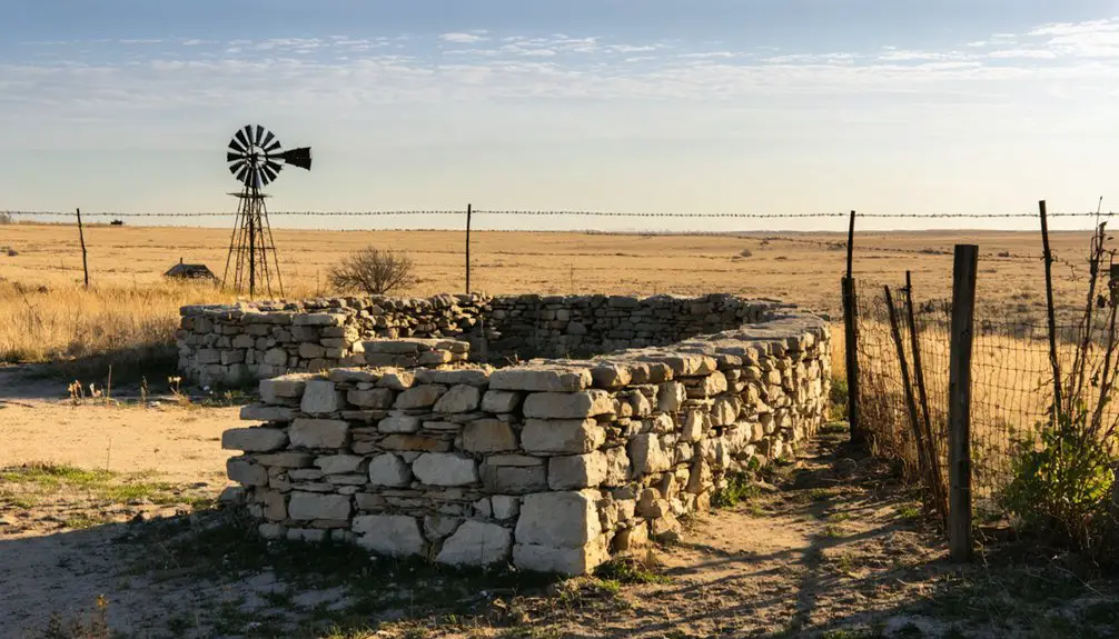
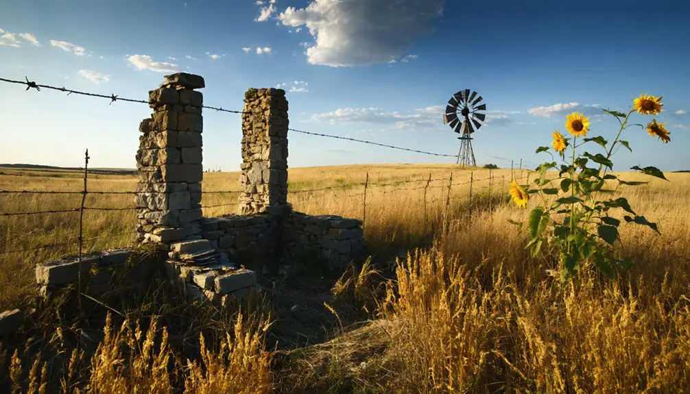
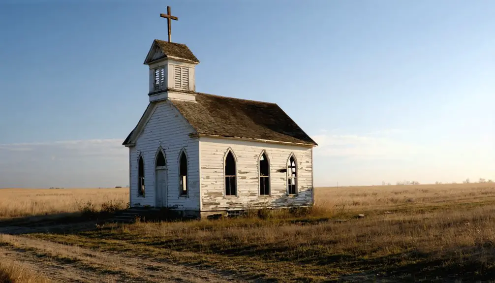
Notable Landmarks and Structures
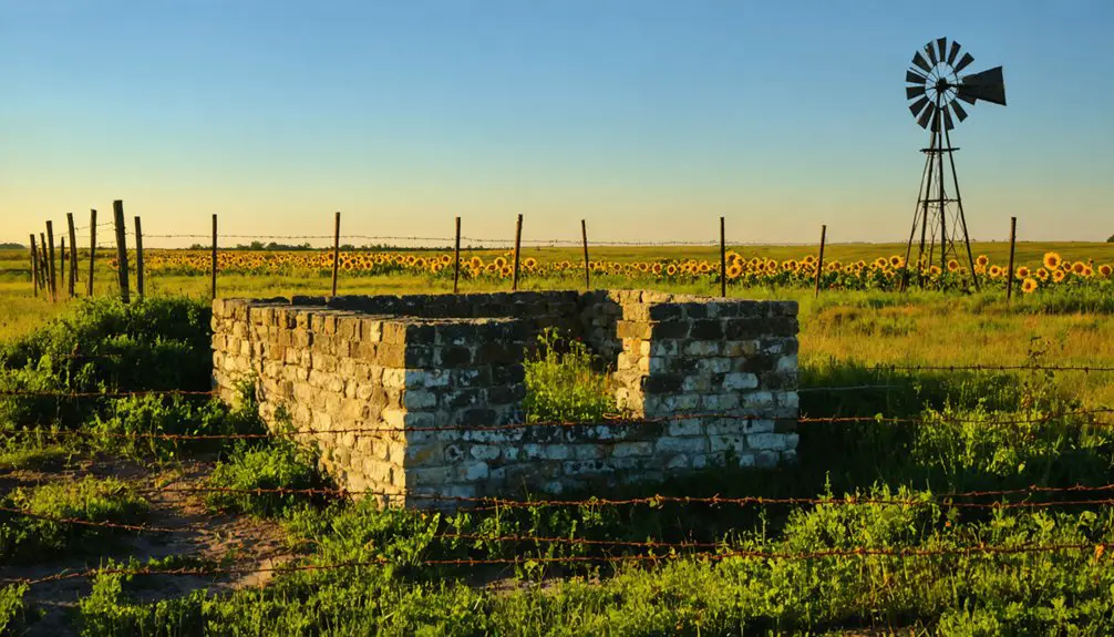
Today’s visitors to Basil encounter scattered remnants of the town’s historic structures, with root cellars, old wells, and territorial-period cemeteries marking the ghostly landscape.
Remnants of frontier life linger in Basil’s ghostly ruins, where root cellars and weathered cemeteries whisper tales of the past.
You’ll find architectural traces of the community’s vibrant past through deteriorating buildings and weathered ruins near Grasshopper Creek.
Key ghostly remnants you can still explore include:
- Religious structures and school buildings that outlasted other establishments
- Fragments of historic rail lines and bridge structures that once connected Basil to regional transport networks
- Commercial building remains like store foundations and residential ruins featuring surviving chimneys, tiled sections, and concrete bathtubs
While sand dunes and vegetation now dominate many settlement areas, these lasting structures provide tangible connections to Basil’s frontier heritage.
Legacy in Local History
Though now silent, Basil stands as a monument to Kansas’s tumultuous frontier period, particularly during the border conflicts between Kansas and Missouri in the late 19th century.
You’ll find its legacy preserved in local oral histories, cemetery markers, and the cultural memory of Kingman County residents. The ghost town narratives chronicle the challenges faced by early settlers, from establishing essential community services to adapting to economic shifts that eventually led to the town’s decline.
Today, Basil’s historical significance extends beyond its physical remains – it serves as a valuable resource for researchers and metal detecting enthusiasts who uncover artifacts that tell stories of pioneer life.
Local historians continue documenting Basil’s role in shaping regional development and transportation networks during Kansas’s formative years.
Preservation and Documentation Efforts
Preserving Basil’s historical legacy requires a thorough approach combining traditional documentation methods with modern technology.
Through focused preservation strategies and community engagement, you’ll find opportunities to help protect what remains of this Kansas ghost town for future generations.
Local preservation efforts currently focus on:
Today’s efforts to preserve local heritage emphasize strategic planning, community participation, and the careful documentation of our shared history.
- Digital archiving of historical photographs and documents, making them accessible to researchers and community members
- GIS mapping and drone surveys to document remaining structures and foundations, creating detailed records of the site’s layout
- Community-driven initiatives that encourage volunteer participation in archaeological surveys and the collection of oral histories
You can support these efforts by joining local historical societies, participating in documentation events, or contributing to the digital archive of Basil’s history.
Frequently Asked Questions
What Native American Tribes Originally Inhabited the Basil Area Before Settlement?
You’ll find the Kanza (Kaw) and Osage Native Tribes originally claimed this territory as their cultural heritage grounds, using the area’s rich plains for hunting buffalo and establishing seasonal camps.
Were There Any Famous Outlaws or Lawmen Associated With Basil?
While you might search for outlaw legends or lawman tales, historical records don’t show any famous law officers or criminals associated with this area during its brief period as an active settlement.
What Was the Average Price of Land in Basil During Settlement?
You’d have found land values around $1.25 per acre during settlement trends, matching federal Homestead Act rates, though you could’ve claimed 160 acres for just an $18-25 filing fee.
Did Basil Have Any Schools or Churches During Its Brief Existence?
Like footprints in shifting sand, you won’t find evidence of Basil schools or churches during its existence. Historical records suggest the town’s brief lifespan and small population couldn’t sustain these institutions.
What Natural Disasters or Epidemics Affected Basil’s Population Over Time?
You won’t find documented flood impacts or disease outbreaks specifically affecting Basil’s population. While the Kansas-Missouri border region faced natural hazards, no direct evidence shows disasters striking this community.
References
- https://www.youtube.com/watch?v=8imf9ZEYVSA
- https://pastmaps.com/explore/us/kansas/kingman-county/basil/metal-detecting
- https://pastmaps.com/explore/us/kansas/kingman-county/basil/hiking-exploration
- https://www.youtube.com/watch?v=alC1wDdSVvg
- https://thewanderingpigeon.com/2015/10/03/day-of-kansas-ghost-towns/
- https://www.youtube.com/watch?v=iB5rHT14eVI
- https://www.youtube.com/watch?v=ie3zwwHm2Jg
- https://www.kspatriot.org/index.php/articles/13-kansas-people/447-pioneer-life.html
- https://crossroads.humanitieskansas.org/oberlin/exhibit/
- https://www.youtube.com/watch?v=F-eLk9802LI


