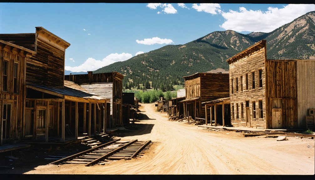
You’ll find Colorado’s most photogenic ghost towns at St. Elmo, Animas Forks, and Crystal Mill, where preserved 19th-century structures create stunning aerial compositions. Capture classic Western storefronts along St. Elmo’s Main Street, or shoot Animas Forks at 11,200 feet amid alpine meadows. For ideal results, fly during fall’s golden hour with propeller guards and full FAA compliance. These mountain locations offer unique perspectives that reward proper planning and technical expertise.
Key Takeaways
- St. Elmo provides exceptional drone shots of preserved Western storefronts along its historic Main Street with mountain backdrops.
- Crystal Mill offers iconic aerial photography opportunities with its dramatic cliffside perch above the Crystal River.
- Animas Forks sits at 11,200 feet elevation, offering stunning high-altitude drone views of alpine meadows and preserved structures.
- Fall photography at Vicksburg captures striking contrasts between golden poplar-lined streets and surrounding rugged canyon walls.
- Winfield features well-preserved historic structures including a schoolhouse and Ball Cabin amid picturesque mountain scenery.
Essential Gear and Safety Considerations for Ghost Town Drone Flights
Before launching your drone to capture Colorado’s historic ghost towns, you’ll need to guarantee compliance with both federal and state regulations while carrying essential gear.
Start with drone registration if your aircraft weighs over 0.55 pounds and keep proof of your completed TRUST certification on hand during flights.
Remember: All drones over 0.55 pounds must be registered with the FAA and operators must carry proof of TRUST certification.
Pack propeller guards for safety, especially when flying near historic structures. Your pre-flight checklist should include weather conditions – avoid flying during Red Flag Warnings or High Wind events that could compromise control.
Bring documentation of any required permits, particularly when operating near protected lands or structures. Review local regulations and use tools like B4UFLY or AirMap to verify airspace restrictions before flying. Maintain visual line of sight at all times and stay under 400 feet altitude. Commercial operators must obtain Part 107 certification before conducting any paid photography missions.
Consider adding safety features if you’re planning shots that might position your drone over people or vehicles.
Top Ghost Town Locations and Their Unique Aerial Perspectives
While Colorado’s ghost towns each tell unique stories of the Old West, five locations stand out for their exceptional drone photography potential.
St. Elmo views capture classic Western storefronts along a dusty Main Street, while Animas Forks isolation at 11,200 feet delivers stunning shots of alpine meadows dotted with historic structures.
Vicksburg contrasts reveal poplar-lined streets against rugged canyon walls, perfectly complementing Winfield structures like the preserved schoolhouse and Ball Cabin.
For the ultimate mountain shot, Crystal Mill beauty beckons with its precarious perch above the Crystal River, surrounded by towering peaks. The Aspen Historical Society offers guided tours that provide historical context for capturing authentic period-accurate footage.
Modern UAS technology enables photographers to document these sites with unprecedented detail and perspective, helping preserve Colorado’s rich mining heritage.
Each location offers unique angles – from preserved wooden architecture to high-altitude ruins – letting you capture Colorado’s mining heritage from perspectives that ground-based photographers can’t achieve.
Weather and Seasonal Planning for Mountain Ghost Town Photography
Successful ghost town drone photography in Colorado’s mountains demands strategic seasonal planning and weather awareness. Each season brings distinct opportunities and challenges that’ll shape your aerial captures.
Exploring the best astrophotography spots in Colorado allows photographers to capture the stunning night sky while highlighting the unique landscapes of the state. Locations like Rocky Mountain National Park and the Great Sand Dunes National Park offer breathtaking vistas and minimal light pollution, making them ideal for celestial captures. As you plan your outings, consider the lunar calendar and weather conditions to maximize your chances of achieving spectacular shots.
Summer offers lush backdrops and comfortable temps but requires dodging afternoon thunderstorms. Fall’s golden aspens create stunning color contrasts, while crisp air improves visibility. Peak foliage from mid-September to October delivers the most dramatic autumn shots. Capturing locations like Crystal Mill provides iconic Colorado fall imagery.
Winter delivers dramatic snow-capped scenes but challenges you with battery drain and limited access. Spring’s melting snow reveals hidden structures amid rushing waterfalls.
Weather impacts vary dramatically with elevation, dropping 3-5°F per 1,000 feet gained. You’ll need to monitor wind conditions, keeping flights under 20 mph gusts.
Plan shoots during golden hours for ideal lighting, and watch for seasonal variations in daylight duration that affect your shooting windows.
To legally operate your drone at Colorado’s historic ghost towns, you’ll need to navigate a complex web of federal, state, and local regulations that protect these cultural treasures.
Colorado state law mandates that drone pilots comply with all FAA regulations while operating near historic sites. Start by securing your Part 107 certification and registering your drone with the FAA. You’ll also need Remote ID compliance for most operations. Government personnel conducting official ghost town surveys may operate under a Certificate of Authorization.
Many ghost towns fall under multiple jurisdictions, requiring permits from various agencies. Check if your target site requires special-use permits from county parks, state lands, or municipal authorities.
Historic preservation guidelines often restrict drone takeoff and landing zones to protect fragile structures. Site access may require additional documentation, including proof of insurance with specific coverage minimums.
Plan ahead – permit processing can take weeks, especially when multiple agencies are involved.
Advanced Composition Techniques for Ghost Town Aerials
Mastering aerial composition at ghost towns demands precise control over three key variables: altitude, perspective, and timing.
You’ll need to switch between low flights (10-40m) for textural details and higher altitudes (120m+) for revealing landscape patterns that drive your aerial storytelling. Creating dynamic shots requires maintaining lower elevations when possible.
For compositional harmony, leverage natural leading lines like abandoned railbeds and erosion gullies to guide viewers’ eyes.
Position these elements at rule-of-thirds intersections, and use orbital passes to create dynamic radial compositions around central ruins.
You’ll capture the most compelling shots during golden hour, when long shadows define structure forms and reveal hidden features.
Vary your camera pitch between nadir and oblique angles, combining both for multi-scale narratives. Consider adjusting your gimbal between 30-60 degrees for enhanced dimensional depth.
Remember to bracket your altitudes within single flights to produce focus-stacked images that tell complete stories from detail to landscape.
Frequently Asked Questions
Which Ghost Towns Have Cell Phone Coverage for Remote Drone Controller Connectivity?
You’ll find reliable cell service availability at St. Elmo and Gilman, minimizing drone connectivity challenges. Animas Forks and Carson present dead zones due to extreme elevation and remote locations.
Are There Designated Drone Landing Zones Near Any of These Sites?
You won’t find designated drone landing zones at these sites. Follow FAA drone regulations and scout your own suitable landing areas while respecting historic structures. No special landing permits required.
What Wildlife Encounters Should Drone Pilots Prepare for at These Locations?
Dare to share the skies? You’ll encounter moose, bears, and mountain lions while flying. Keep your distance from raptors’ nests, watch for elk during rutting season, and monitor wildlife sightings before takeoff.
Do Any Ghost Towns Offer Guided Drone Photography Tours or Workshops?
You won’t find official guided drone tours, but you’ll need to self-navigate drone regulations while exploring. Consider joining Ghost Town Club’s workshops for photography tips and site-specific mapping expertise.
Can You Camp Overnight at These Ghost Towns for Sunrise Shots?
You’ll find most ghost towns restrict overnight camping due to preservation rules. For sunrise shots, you’re better off camping at designated sites nearby – like setting up at Mineral Creek Campground near Animas Forks.
References
- https://303magazine.com/2017/10/colorado-ghost-towns/
- https://www.mountainwestuas.org/blog/ghost-town-historical-preservation-featured-in-december
- https://www.uncovercolorado.com/ghost-towns/
- https://www.youtube.com/watch?v=N0mNOeRG-lk
- https://video.storyful.com/record/27758
- https://mike-butler.com/crystal-mill-colorado_ghost_town/
- https://photographerstrailnotes.com/colorado-preview/a-room-wtih-a-view-photographers-guide
- https://www.youtube.com/watch?v=VWryCl2srp0
- https://www.jeevesdrones.com/post/colorado-drone-laws-2025
- https://skydronesolutions.com/drone-photography-regulations-in-denver/


