You’ll find exceptional drone photography at ghost towns across the Desert Southwest, with locations like Cerro Gordo and Castle Dome offering dramatic aerial compositions. Plan your shoots during winter months or spring blooms, focusing on golden hour lighting for the best results. Pack reliable equipment like the DJI Mini 4 Pro, carry multiple batteries, and secure necessary permits before flying. These abandoned settlements hold countless untold stories waiting to be captured from above.
Key Takeaways
- Cerro Gordo offers exceptional aerial photography opportunities with its well-preserved silver mine structures and dramatic mountain backdrop.
- Castle Dome’s intact buildings provide striking contrast against the desert landscape, perfect for isolation and perspective shots.
- Nelson ghost town features photogenic rusted machinery and vintage vehicles ideal for detailed low-altitude drone photography.
- Winter months provide optimal conditions with mild temperatures and crisp air visibility for drone photography in Southwest ghost towns.
- Golden hour shoots, particularly during early morning or late afternoon, deliver the best lighting for capturing weathered structures.
Planning Your Ghost Town Drone Adventure
While ghost towns of the American Southwest beckon drone photographers with their haunting beauty, proper planning guarantees both access and memorable footage.
Your itinerary planning should focus on winter months when temperatures are mild, or spring when wildflowers paint the desert landscape. Consider early morning or late afternoon shoots for ideal lighting conditions. Some locations like Castle Dome require a 2-hour exploration window to fully capture all the historic structures. Bring navigation tools like Google Earth maps to efficiently locate hidden historical sites.
Desert magic peaks in winter’s mild embrace and spring’s wildflower display, while golden hours promise perfect light for capturing ghost towns.
You’ll need to secure permits and reservations, especially for sites like Ruby Ghost Town. Check drone regulations carefully – while locations like Rhyolite welcome aerial photography, national parks enforce strict no-fly zones.
Base yourself near amenity-rich towns like Cottonwood or Beatty for convenient access to historic sites. Most ghost towns sit along dirt roads, so factor vehicle requirements into your plans.
Pack for variable desert conditions and time zone changes when crossing state lines.
Essential Equipment and Safety Protocols
Since ghost town photography demands reliable equipment in challenging desert conditions, you’ll need both consumer and professional-grade drone models equipped for the terrain. The DJI Mini 4 Pro and Inspire 3 excel in desert environments, offering superior image quality and reliable obstacle avoidance systems essential for traversing abandoned structures. Utilizing thermal imaging sensors helps reveal hidden structural details in deteriorating buildings.
Arizona’s intense temperatures can reduce battery efficiency dramatically, so pack at least three fully charged batteries to maximize your shooting time during golden hour, and don’t forget your charger for extended sessions.
You’ll want to protect your gear with ND filters for harsh sunlight control and keep a lens cleaning kit handy for inevitable dust exposure.
Remember that while lightweight drones mightn’t require FAA registration, you’ll still need to verify local regulations and secure proper clearance for commercial shoots.
Maintain your equipment regularly and check battery life before each flight in extreme desert heat.
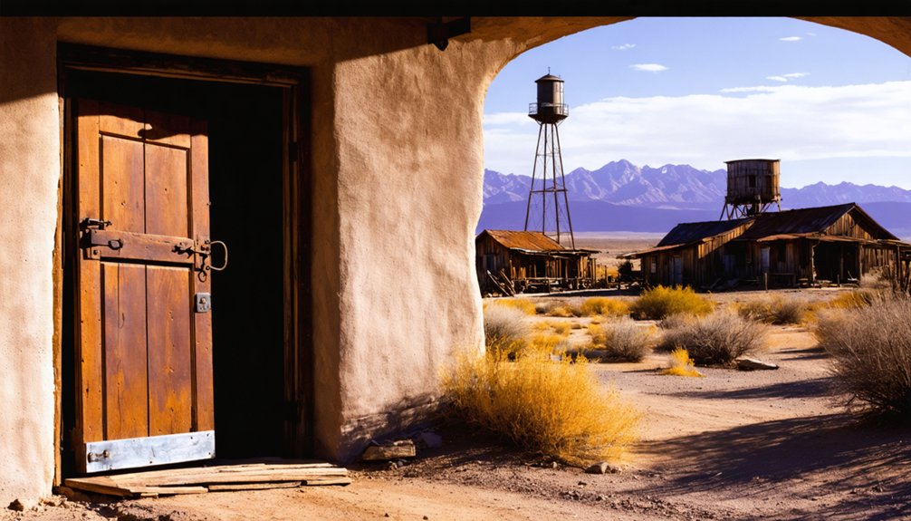
Top Locations for Dramatic Aerial Compositions
Throughout the American Southwest, abandoned mining settlements offer photographers an array of compelling aerial perspectives, from well-preserved ghost towns to weathered ruins set against dramatic desert landscapes.
Your drone can capture the stark beauty and rich history of these remote outposts while revealing hidden patterns and textures from above. Since its recent $1.4 million acquisition, Cerro Gordo has become increasingly popular among drone photographers seeking to document historic mining sites.
- Cerro Gordo’s clustered silver mine structures create striking geometric shapes against the Owens Valley backdrop, perfect for wide-angle aerial compositions.
- Castle Dome’s standing buildings contrast beautifully with the surrounding desert, ideal for isolation shots and texture studies.
- Rusted machinery and vehicles scattered across Nelson provide rich detail for low-altitude cinematic runs.
- Mountain-shadowed settlements offer dramatic light plays during golden hour, especially when capturing high-dynamic-range panoramas of building clusters against towering peaks.
The town of Lello provides unique aerial photography opportunities with its three railroad intersections from its 1882 founding, offering compelling geometric patterns from above.
Optimal Times and Weather Conditions
To capture the most compelling aerial photographs of ghost towns, timing and weather conditions shape your creative possibilities.
You’ll find the richest light during golden hour, starting 30-60 minutes before sunrise or sunset, when warm rays paint weathered wood and rusted metal with dramatic highlights. For expansive aerial shots, winter’s crisp air delivers superior visibility across the Desert Southwest. Many photographers find success capturing the old rock buildings that remain preserved in these historical sites. Seeking vantage points near Whitney Pocket offers peaceful wilderness shots without tourist crowds.
Avoid harsh midday light between 10:00-16:00, when strong contrast challenges your dynamic range. If you must shoot midday, use polarizing filters and seek elevated positions to maximize shadowed details.
Fall offers ideal conditions with stable weather and clear skies, while spring shifts create dramatic storm backgrounds. Watch for monsoon threats July through September – wet conditions can ground your drone and damage gear.
Legal Guidelines and Site Access Requirements
Before launching your drone at any ghost town site, you’ll need to navigate a web of federal, state, and local regulations that govern aerial photography. Proper drone registration with the FAA is essential if your aircraft weighs more than 0.55 pounds, and you’ll need to display your operator ID clearly on the device. Consider obtaining drone liability insurance to protect against potential accidents or damage claims. Accessing controlled airspace requires advance authorization through the LAANC system.
- Secure written permission from property owners before flying over ghost town sites, even if they appear abandoned.
- Check local privacy laws, as states like Texas and California have strict regulations about aerial photography of private spaces.
- Stay below 400 feet and maintain visual line of sight while capturing your shots.
- Research municipal drone restrictions – many cities require special permits for historic areas.
Remember to store your footage securely and edit out any accidentally captured identifying features of modern structures or vehicles near the ghost town.
Frequently Asked Questions
How Can I Prevent Dust Damage to My Drone While Landing?
Use a landing pad, maintain slow descent, approach from upwind, and keep steeper angles. You’ll minimize dust kickup while protecting your drone’s motors and electronics from damaging particles.
Which Drone Filters Work Best for Reducing Desert Glare?
You’ll get the best glare reduction using polarizing filters for reflective surfaces and ND filters for bright sunlight. Combine them with an ND/PL filter when you need both exposure control and reflection management.
Are There Ghost Towns That Offer Night Photography Permits?
Like stars piercing darkness, you’ll find night photography permits at Bodie State Historic Park through workshops, Nelson Ghost Town via private bookings, and Calico Ghost Town through special commercial arrangements.
What Resolution Settings Capture the Finest Details in Weathered Buildings?
You’ll capture the sharpest weathering details by shooting RAW at your drone’s highest native resolution, using base ISO, and maintaining a GSD under 2cm through precise altitude control.
How Close Can Drones Safely Fly Near Partially Collapsed Structures?
With 90% of drone accidents occurring within 100 feet of structures, you’ll want to maintain at least 50 feet clearance from unstable buildings while following drone regulations and safety guidelines.
References
- https://www.youtube.com/watch?v=SXW3te7OTC8
- https://pamphotography.blog/2023/05/22/photographing-four-ghost-towns-in-arizona/
- https://www.airvuz.com/collection/video/birds-eye-views-of-the-southwestern-usa?id=HJd5LX_dX
- https://www.airvuz.com/video/Cerro-Gordo-Ghost-Town?id=5d08a204154be13ae9e52aec
- https://www.youtube.com/watch?v=EM3kfcYbzDA
- https://blog.annemckinnell.com/2014/05/08/light-painting-ghost-town/
- https://www.youtube.com/watch?v=-er4dnYAXo8
- https://blog.annemckinnell.com/2013/07/09/rhyolite-ghost-town/
- https://www.youtube.com/watch?v=km3_kVera6E
- https://www.youtube.com/watch?v=sOmlDZv5j2Y


