You’ll find exceptional drone photography opportunities across the Great Plains’ ghost towns, where vast horizons and clear skies create perfect conditions for aerial imagery. Montana’s mining remnants, Kansas’s decaying Main Streets, and Nebraska’s Chimney Rock region offer diverse architectural subjects enhanced by dramatic weather patterns and seasonal changes. For best results, plan your shoots during golden hour with winds under 15mph and secure necessary permits. The Plains’ forgotten frontiers hold countless untold stories waiting to be captured from above.
Key Takeaways
- Kansas’s decaying Main Streets offer compelling compositions with linear patterns and dramatic shadows perfect for aerial photography.
- Montana ghost towns feature well-preserved mining structures against mountainous backdrops, ideal for dramatic drone perspectives.
- Nebraska’s Chimney Rock region combines natural landmarks with abandoned settlements, creating unique visual narratives from above.
- The Dakotas’ river valleys contain remote ghost towns with pristine structures and minimal modern interference.
- Great Plains ghost towns provide unobstructed horizons and clear visibility, maximizing drone photography potential in dry, crisp conditions.
What Makes Great Plains Ghost Towns Uniquely Photogenic
While ghost towns across America offer compelling subjects for aerial photography, the Great Plains region presents an unmatched canvas for drone operators due to its distinct geographical and architectural characteristics.
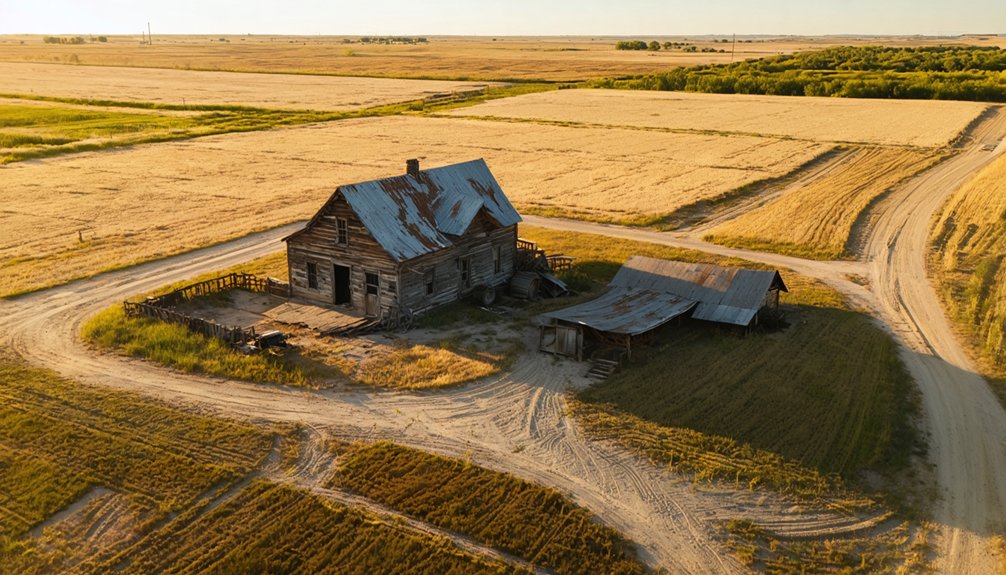
The vast, unobstructed horizons and flat terrain create ideal conditions for aerial storytelling, with agricultural patterns and seasonal changes providing ever-shifting compositional elements. Before visiting these locations, thorough research is necessary to ensure proper access and permissions. Many of these sites stand as stark reminders of the Dust Bowl exodus that forever changed the landscape.
Endless Plains skies stretch beyond sight, where seasonal rhythms paint nature’s canvas through the watchful eye of hovering lenses.
You’ll find abandoned beauty amplified by the region’s unique light characteristics – clear, dry air enables crisp long-range visibility, while low sun angles cast dramatic shadows across deteriorating structures.
The Plains’ architectural remnants tell compelling stories from above: collapsed rooflines, clustered building formations, and linear artifacts like rail spurs and fencing create strong visual narratives.
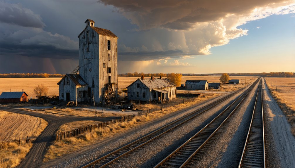
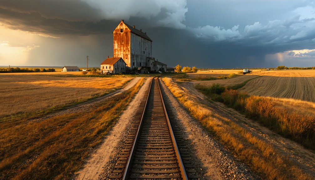
When combined with the dramatic weather patterns and cloudscapes typical of the region, these elements deliver unparalleled opportunities for drone photography.
Essential Drone Equipment for Plains Ghost Town Photography
You’ll need a drone equipped with at least a 1-inch sensor and RAW capability to capture the dramatic light and textures of Plains ghost towns effectively.
Your kit must include a 3-axis gimbal, ND filters, and polarizers to handle the region’s strong winds and harsh sunlight while maintaining professional image quality.
Multiple batteries, high-speed storage cards, and portable power solutions are essential for extended shooting sessions at remote locations where charging options don’t exist.
Consider the DJI Zenmuse X5 with its 15mm f/1.7 lens for superior image quality when photographing abandoned structures and weathered architectural details.
For commercial ghost town photography, obtaining proper Part 107 certification is legally required before conducting any aerial shoots of these historic sites.
Drone Camera Selection Tips
Selecting the right drone camera system proves essential for capturing the rich textures and dramatic contrasts of plains ghost towns. When evaluating sensor selection and lens considerations, focus on equipment that delivers professional-grade imagery while maintaining the flexibility to shoot in challenging conditions. For maximum creative control, consider models like the DJI Mavic 3 Pro with its triple-camera system that provides unmatched versatility.
- Choose 1-inch or larger sensors for superior dynamic range when photographing weathered buildings and shadowy interiors.
- Opt for drones supporting RAW capture to maximize post-processing potential.
- Select systems with dual cameras offering both wide-angle and telephoto perspectives.
- Guarantee your drone has mechanical stabilization and precise exposure controls.
- Look for platforms supporting HDR or exposure bracketing to handle high-contrast scenes.
The Ocusync 4 technology in newer drone models ensures reliable transmission and stable connections when navigating around tall structures and across ghost town sites. These technical capabilities will empower you to document these historic sites with the detail and quality they deserve, while respecting their fragile nature.
Weather-Ready Gear Essentials
Plains ghost towns present unique weather challenges that demand specialized drone equipment for successful aerial photography.
You’ll need extensive weather monitoring tools, including a portable weather meter for real-time wind speed and temperature readings, plus aviation apps with low-altitude radar layers to track incoming weather systems.
Protect your drone with strategic modifications like IP65+ waterproofing for sudden rain, hydrophobic lens coatings to maintain image clarity, and removable prop guards for gusty conditions. Always maintain a 30% safety buffer when operating in high winds near manufacturer limits. Using a waterproof hardshell case for transport is essential to protect your equipment from unexpected storms.
Manage your batteries with insulated carrying cases and temperature monitoring systems, especially during extreme plains temperatures.
Set up a lightweight pop-up windbreak at your launch site and use a folding ground pad to shield your gear from dust and moisture.
These adaptations will keep you flying when conditions would otherwise ground less-prepared operators.
On-Site Power Solutions
When photographing remote ghost towns across the plains, reliable power solutions become critical for sustaining extended drone operations. Your battery logistics need to accommodate multiple flights while maintaining power efficiency in challenging environments. Like the 20,000 mining sites that once dotted Colorado’s landscape, these locations require extensive coverage and multiple battery changes. Employing mounted Lume Cubes provides essential lighting for nighttime shoots of abandoned structures.
A thorough power setup guarantees uninterrupted shooting sessions across vast abandoned locations.
- Deploy a 1000-3000W portable inverter generator as your primary power hub for extended missions
- Utilize solar generators with foldable panels for silent operation during daylight hours
- Set up a dedicated battery station with multi-channel smart chargers for rapid turnaround
- Implement temperature management systems using insulated coolers and ventilated shade structures
- Install surge-protected power distribution with weatherproof outlets and pure sine wave inverters
These power solutions provide the independence needed to capture ghost towns from dawn to dusk without interruption.
Top Ghost Town Locations Across the Plains States
When you’re planning drone photography of Plains ghost towns, you’ll find the most compelling sites clustered along three major corridors: the Northern Plains’ abandoned rail towns, Kansas-Nebraska’s agricultural ruins, and the Texas-Oklahoma oil country remnants.
You’ll need to master the logistics of reaching these remote locations, often requiring advance permissions from private landowners and careful route planning across vast distances between sites.
The region’s volatile weather patterns demand strategic scheduling around dawn and dusk golden hours, while accounting for seasonal wind patterns that can impact flight stability, particularly near towering grain elevators and exposed plains.
Plains Ghost Town Essentials
Throughout America’s vast heartland, ghost towns scatter across the Plains states like weathered sentinels of bygone eras, offering drone photographers unprecedented opportunities to capture the region’s abandoned architecture and forgotten histories.
From Kansas’s decaying Main Streets to Montana’s mining remnants, these sites tell stories of architectural decay and ghost town history through your lens.
- Nebraska’s Chimney Rock region provides dramatic geological backdrops for structural compositions
- Kansas’s western counties offer extensive farmstead clusters ideal for wide-angle aerials
- Montana’s intact banks and churches create compelling vertical framing opportunities
- The Dakotas’ river valleys showcase grain elevators perfect for golden-hour silhouettes
- Oklahoma and Texas Panhandle corridors deliver linear perspective shots along former rail lines
Master these locations, and you’ll capture the essence of Plains abandonment through your drone’s eye.
Remote Site Access Tips
Before commencing your Plains ghost town drone expedition, you’ll need to master the complex logistics of accessing these remote historical sites.
Navigate terrain considerations by securing high-clearance 4WD vehicles equipped with recovery gear, as unmaintained county roads and rutted ranch tracks pose significant access challenges.
Map your route using offline navigation systems and cached satellite imagery, since cellular coverage remains sparse across the Plains.
You’ll need to verify land ownership through county assessor records and obtain written permissions from private landowners before entering properties.
Coordinate with local authorities via non-emergency lines to prevent trespassing concerns.
Carry satellite communicators for emergency communication, share detailed itineraries with trusted contacts, and maintain dual navigation systems with backup power sources to guarantee safe exploration of these isolated historical treasures.
Weather Planning Strategies
Successfully traversing Plains ghost town weather patterns requires detailed seasonal forecasting to maximize drone photography opportunities. The region’s dramatic seasonal changes demand careful planning for ideal flight conditions and equipment protection.
- Monitor NOAA 7-10 day forecasts for wind speeds under 15 mph, especially in Nebraska’s Chimney Rock vicinity during peak June-September conditions.
- Track severe weather patterns April-June when tornadoes frequent Kansas, Nebraska, and Oklahoma ghost town corridors.
- Plan southern Plains visits (Oklahoma, Texas) during winter months for milder 40-60°F temperatures.
- Utilize UAV Forecast and Weather Underground for hyperlocal ghost town predictions.
- Schedule dawn/dusk flights when temperatures stabilize between 50-70°F, avoiding battery-draining extremes.
Consider diurnal temperature swings of 30-40°F when timing your ghost town drone operations, particularly in exposed Plains locations.
Planning Your Ghost Town Drone Flight Schedule
Proper flight scheduling forms the cornerstone of any ghost town drone photography mission, especially across the vast Plains region where abandoned settlements often lie hours apart on unmaintained roads.
Strategic planning and precise scheduling make ghost town drone photography possible when navigating the remote settlements of America’s Plains.
You’ll need to meticulously verify drone regulations, checking TFRs and controlled airspace status through FAA tools before each flight. Factor in land access permissions, whether public, private, or tribal, securing written approvals well in advance.
Your flight planning should account for early morning sessions when visitor traffic is minimal and lighting conditions are ideal.
Pack redundant batteries and portable charging stations, as you won’t find power sources in these remote locations. Schedule equipment checks and firmware updates before departure, and always reserve time for thorough site hazard assessments to identify structural risks and obstacles.
Weather Considerations and Seasonal Shooting Tips
When planning ghost town drone photography in the Great Plains, you’ll need to carefully navigate the region’s notoriously volatile weather patterns, particularly during the peak severe weather season from mid-May through July.
Understanding seasonal changes is essential for capturing the best shots while maintaining safety.
- July offers peak visibility for storm damage patterns against verdant landscapes
- Lightning risks require rooftop launches to protect your equipment and yourself
- Early morning flights avoid afternoon supercell development common to the region
- Winter ice storms create unique crystalline landscapes for dramatic aerial shots
- Eastern Colorado’s terrain provides perfect sunset opportunities outside storm windows
Consider how storm patterns affect visibility, especially during June-July when thunderstorm towers dominate the landscape.
Time your shoots around weather windows, leveraging the region’s geological features while maintaining situational awareness of developing severe weather.
Permits, Permissions, and Legal Requirements
Maneuvering the complex web of drone regulations requires thorough understanding of federal, state, and local requirements before photographing ghost towns.
You’ll need to register your drone with the FAA if it weighs over 0.55 pounds and maintain visual line of sight while flying below 400 feet.
Check if your ghost town site lies within National Park boundaries, where drone operations are strictly prohibited, or National Forest land, where flights are generally permitted with restrictions.
Many Great Plains ghost towns sit on private property, requiring landowner consent per state laws like Oklahoma HB 3171 and Texas HB 912.
If you’re planning commercial photography, you’ll need Part 107 certification.
For BLM-managed sites, launch and land only on designated routes, and remember that wilderness areas are off-limits for drone operations.
Creative Shot Ideas and Composition Techniques
Capturing compelling ghost town aerials requires mastering both fundamental composition principles and drone-specific techniques. To disclose abandoned beauty through visual storytelling, you’ll need to leverage strategic positioning and timing while maintaining technical precision in your drone operations.
- Frame wide-angle aerial shots at golden hour to emphasize isolation, using converging lines like railroad tracks or fence rows to draw viewers into the scene.
- Deploy low-altitude oblique angles to reveal weathered façades while maintaining geographic context with visible horizon lines.
- Capture vertical top-down perspectives to showcase geometric patterns in grid layouts and architectural features.
- Utilize HDR bracketing during dynamic weather conditions to preserve detail in high-contrast scenes.
- Create before/after sequences by documenting intact structures alongside collapsed sections, incorporating human-scale elements for reference.
Safety Guidelines for Abandoned Structure Documentation
Safe exploration of ghost towns demands rigorous preparation and strict adherence to established protocols, given the inherent dangers of deteriorating structures and remote locations.
Before launching your drone, conduct thorough structural assessments of buildings to identify potential hazards like unstable roofs or collapsing walls.
You’ll need to prioritize abandoned safety by equipping yourself with protective gear, including N-95 respirators and heavy-duty boots.
Don’t venture alone – always bring a companion and inform others of your plans.
Your drone should have propeller guards and powerful lights for traversing dim interiors.
Frequently Asked Questions
How Do You Handle Curious Onlookers When Filming Ghost Towns?
ote題anseeurs парактеししяbox
What Backup Locations Are Recommended if Primary Sites Are Inaccessible?
You’ll find reliable alternative sites at state-managed ghost towns like Bannack and Garnet in Montana, where photography permits are pre-arranged and access is guaranteed through established visitor infrastructure.
Are There Haunted Locations Where Drones Have Experienced Unexplained Malfunctions?
While you’ll hear tales of drone anomalies at haunted sites, documented malfunctions typically trace to electromagnetic interference, GPS signal loss, or structural obstacles – not paranormal activity disrupting your flight systems.
Which Ghost Towns Offer the Best Night Sky Photography Opportunities?
You’ll find ideal night sky conditions in Kendall, Montana, where pristine Bortle Class 2 skies and historic structures create perfect foreground elements. Capture compelling shots during new moon phases for maximum star visibility.
How Do Seasonal Changes in Vegetation Affect Ghost Town Drone Compositions?
Like nature’s canvas unfolds, you’ll find seasonal contrasts shape your shots dramatically – summer’s dense foliage conceals details, while winter’s bare vegetation reveals hidden structures and creates stark, geometric patterns for aerial compositions.
References
- https://www.airvuz.com/collection/video/the-usas-great-plains-region-from-above?id=SkjpZ4esQ
- https://www.youtube.com/watch?v=tYxwkDCs3o4
- https://mike-butler.com/crystal-mill-colorado_ghost_town/
- https://www.youtube.com/watch?v=IECzqQ-jIEM
- https://www.youtube.com/watch?v=mgBEQbnaT6A
- https://www.youtube.com/watch?v=VWryCl2srp0
- https://pamphotography.blog/2023/07/08/how-to-photograph-ghost-towns/
- https://www.legendsofamerica.com/gt-emergingghosttowns/
- http://www.momentsinlightphoto.com/2017/12/ghosts-of-plains-black-hills.html
- https://wbkr.com/historic-mountain-ghost-town-awaits-your-next-east-tn-visit/


