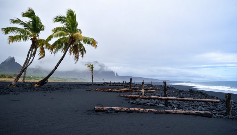
You’ll find exceptional drone photography opportunities at Hawaii’s ghost towns, with Kalapana and Kaimū on the Big Island offering dramatic shots of lava-blackened landscapes and structural remnants. For compelling aerial compositions, target the abandoned sugar plantations in Honoka’ā, ancient fishing villages at Lapakahi, and the geometric patterns of Kohala’s agricultural ruins. Don’t forget your ND filters and FAA registration – proper planning and cultural sensitivity will open access to these haunting historical treasures.
Key Takeaways
- Kalapana and Kaimū offer dramatic landscapes of abandoned homes and buildings overtaken by lava flows, perfect for aerial photography.
- The abandoned sugar plantations in Honoka’ā and Waipi’o Valley create stunning geometric patterns ideal for wide-angle drone shots.
- Kikala-Keokea subdivision presents modern ghost town scenery with partially completed streets and foundations against volcanic terrain.
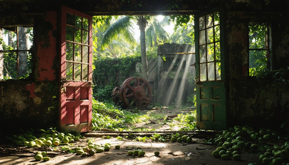
- Punaluu Village Restaurant ruins provide compelling coastal shots of a once-thriving establishment destroyed by natural disasters.
- Lapakahi’s ancient fishing village ruins showcase 600 years of coastal settlement history through well-preserved stone structures.
Planning Your Drone Ghost Town Adventure in Hawaii
Before launching your drone over Hawaii’s historic ghost towns, you’ll need to navigate a complex web of regulations and technical considerations.
Start by registering your drone with the FAA if it’s over 0.55 pounds and download the B4UFLY app to check airspace restrictions. Secure necessary drone permissions for specific locations like Pu’uhonua o Honaunau National Historic Park. For an authentic Hawaiian ghost town experience, be sure to include Wai Opae on your shot list, known for its historic brackish water shrimp farming operations.
Plan your shoots during early morning hours when trade winds are calmest, typically below 10 mph. Scout locations via Google Earth and pack essential gear including ND filters for harsh tropical light. The Tunnels Beach cliffs provide dramatic backdrops for abandoned structures along the North Shore.
The DJI Mini 3 Pro offers excellent photography techniques while staying under the 250g threshold for fewer regulations. Remember to maintain visual line of sight and stay below 400 feet altitude while capturing these abandoned treasures.
Top Abandoned Sites on The Big Island
You’ll find compelling aerial subjects among Hawaii’s ancient coastal ruins, where lava-consumed villages like Kalapana and Kaimū offer stark compositional contrasts between blackened landscapes and remaining structural elements.
The scattered fishponds and lo’i systems along the Ka’ū and Hāmākua coasts present ideal opportunities for orthogonal drone shots that document pre-contact engineering. The newer Kikala-Keokea subdivision, established with 67 lots for displaced Native Hawaiian families, provides a modern counterpoint to the area’s historical sites. The abandoned Punaluu Village Restaurant, once a thriving tourist destination in the 1970s, now stands as a haunting reminder of natural disaster impact.
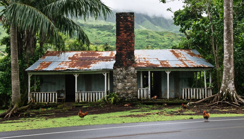
Moving inland, the abandoned sugar plantations and agricultural remnants of Honoka’ā and Waipi’o Valley create layered patterns that you can capture through wide-angle panoramas and golden-hour passes.
Ancient Coastal Village Ruins
Along Hawaii’s rugged coastline, ancient village ruins offer drone photographers a rare glimpse into centuries of Native Hawaiian life through perfectly preserved stone structures and petroglyphs.
You’ll discover prime aerial shooting locations at Lapakahi’s ancient fishing village, where unmortared lava walls and reconstructed hales showcase 600 years of coastal settlements. The site’s self-guided tour paths provide convenient vantage points for setting up drone shots while respecting the historic structures.
For stunning compositions, capture Pu’ukohola Heiau’s massive temple walls at sunrise, when the red stones glow against the dramatic terrain. The temple stands as a testament to King Kamehameha’s unification of the Hawaiian Islands.
At Kaloko-Honokohau, your drone can frame the intricate fish ponds and sea walls that highlight traditional engineering skills.
Don’t miss the extensive petroglyph fields at Waikoloa and Puako, where cryptic carvings etched in black lava create compelling geometric patterns when shot from above.
Inland Agricultural Remnants
Deep within Hawaii’s rugged interior, abandoned agricultural systems offer drone photographers rare opportunities to document ancient Hawaiian ingenuity from above.
The extensive Kohala Field System spans 25 square miles, revealing intricate patterns of mounds and depressions beneath modern cattle fields. You’ll discover agricultural adaptations across five major systems, from Kaʻū’s strategic stone walls to Kona’s innovative dry-land techniques. These ancient systems once sustained a thriving population of 20,000 to 30,000 inhabitants between 1450 and 1800. The ingenious farmers created kuaiwi stone mounds for cultivating crops and protecting them from harsh winds.
- Capture the geometric precision of Kohala’s nutrient-rich farmlands through your drone’s lens at sunrise when shadows accentuate the ancient techniques.
- Frame the dramatic contrast of Ka’ū’s stone wall remnants against the ocean backdrop using high-altitude passes.
- Document Waimea’s hidden agroforestry sites with infrared sensors to reveal buried agricultural patterns beneath the surface.
Hidden Historical Ruins of Maui and Molokai
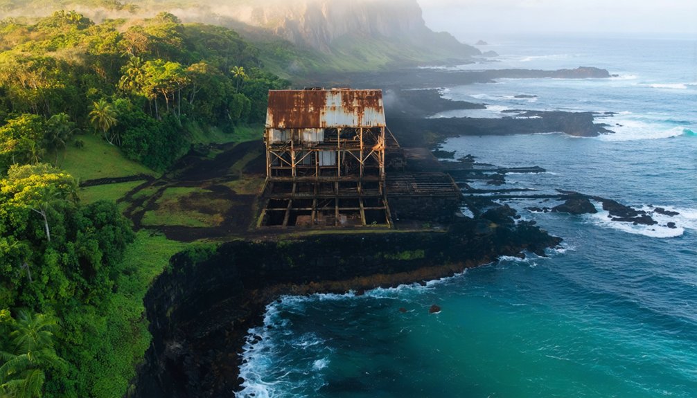
You’ll find exceptional drone opportunities at Maui’s abandoned sugar mills, where rusted machinery and weathered buildings create striking industrial compositions against the tropical landscape.
For a more somber aerial perspective, Molokai’s remote peninsulas offer dramatic views of historic Hansen’s Disease settlement ruins nestled between towering sea cliffs. Near the coast, the 900-year-old Kawela Mound provides a fascinating glimpse into ancient Hawaiian habitation patterns. The majestic seven heiau sites of the Hokukano-Ualapue Complex stand as remarkable monuments along the southeast coastline.
Your drone can capture the stark contrast between ancient Hawaiian heiau structures and modern-day abandonment, especially during golden hour when long shadows emphasize architectural details and cultural significance.
Maui’s Abandoned Sugar Mills
The haunting remnants of Maui’s sugar industry stand as silent witnesses to a 160-year legacy that transformed the island’s landscape.
You’ll find exceptional drone photography opportunities at Puunene Mill’s massive industrial complex, where rusted machinery and towering smokestacks create striking geometric patterns against the tropical backdrop.
At Haiku Mill, nature reclaims the historic ruins through a stunning interplay of light and shadow among the 70+ plant species winding through the stone walls.
- Capture dramatic aerial perspectives of Puunene’s sprawling 36,000-acre footprint at golden hour, when long shadows accentuate the scale of Hawaii’s last operating sugar mill.
- Frame your shots through the deteriorating roof trusses of Haiku Mill, where steam-age technology meets jungle reclamation.
- Experiment with height variations to showcase the contrast between industrial decay and surrounding agricultural renaissance.
Molokai’s Desolate Peninsula Views
Moving beyond Maui’s industrial relics, Molokai’s Kalaupapa Peninsula offers an unparalleled canvas for aerial photographers seeking to document haunting historical ruins against dramatic coastal backdrops.
The peninsula’s abandoned settlement structures, including St. Philomena Church and scattered cemetery markers, create compelling compositions when framed against 1,600-foot sea cliffs.
You’ll need to navigate strict access protocols and cultural sensitivity requirements before launching your drone.
The Kalaupapa ruins demand technical precision in your flight planning – strong winds and FAA restrictions limit operational windows.
For best results, combine low-altitude passes over the former settlement with wider establishing shots that capture the peninsula’s isolation.
Consider scheduling your shoot during golden hour when long shadows emphasize the haunting emptiness of this former Hansen’s disease colony.
Oahu’s Urban Ghost Landscapes From Above
Scattered across Honolulu’s urban fabric, abandoned industrial sites and forgotten structures create compelling aerial compositions for drone photographers willing to navigate the technical challenges.
From derelict sugar processing facilities along the harbor to ghosted pre-war homes in aging neighborhoods, you’ll find rich opportunities for urban exploration through aerial perspectives. Just remember to check airspace restrictions and secure necessary permissions, especially near maritime infrastructure or historic preservation zones.
- Former pineapple warehouses offer industrial textures and linear geometry perfect for orthographic mapping at golden hour.
- Kaka’ako’s disused rail corridors present geometric rooftop patterns and graffiti-covered facades ideal for abstract aerial studies.
- Abandoned coastal bunkers and military structures provide historically layered subjects for dramatic top-down symmetry shots.
The key is timing your flights around thermal updrafts and port operations while maintaining conservative wind margins near high-rises.
Kauai’s Remote Coastal Remnants
Along Kauai’s rugged coastline, three distinct heritage sites offer drone photographers exceptional opportunities to capture Hawaii’s ancient past from above.
At Nā Pali’s Nuʻalolo Kai, you’ll encounter stone terraces ideal for orthomosaic mapping, though strong trade winds demand robust flight control.
The Polihale dune system reveals ancient heiau remnants threatened by coastal erosion, perfect for dramatic sunrise compositions – but you’ll need to navigate cultural sensitivities and remote staging logistics.
Māhā’ulepū Heritage Trail presents a complex canvas of petroglyphs and archaeological preservation sites against dramatic geological formations.
You’ll want high-dynamic-range capabilities to balance shadows and highlights while documenting these features.
Pack light, resilient gear that can handle salt spray and terrain challenges.
Remember to secure necessary permits and respect local cultural protocols when flying these spiritually significant locations.
Essential Safety and Cultural Guidelines
When operating drones at Hawaii’s ghost towns, you’ll need to navigate a complex web of legal, safety, and cultural requirements that protect these sensitive sites.
exploring ghost towns in Hawaii offers a unique insight into the islands’ history and cultural heritage. These abandoned areas provide a fascinating backdrop for drone photography, revealing picturesque landscapes often untouched by modern development. Visitors must engage with the local community and respect the significance of these sites to ensure they are preserved for future generations.
Current drone regulations require FAA registration, TRUST certification for hobbyists, and strict adherence to airspace restrictions. Cultural sensitivity is paramount – always respect wahi kapu (sacred sites) and obtain necessary permits, especially when near archaeological locations.
- Position your drone to capture the weathered structures against dramatic island backdrops while maintaining a respectful 400-foot ceiling.
- Scout stable takeoff zones away from unstable coastal cliffs and historic ruins to protect both your equipment and the site’s integrity.
- Time your flights during ideal lighting conditions, but be prepared for rapid weather changes that can affect your drone’s performance.
Frequently Asked Questions
Can You Fly Drones at Night to Capture Ghost Towns?
You’ll need FAA Part 107 night waivers and anti-collision lighting visible for 3 miles to conduct night drone photography. Most ghost town sites require additional permits and cultural sensitivity clearances.
Which Ghost Towns Have the Most Paranormal Activity Reports?
Like moths to flame, you’ll find the most intense paranormal sightings at Morgan’s Corner and Mākua Cave. These haunted locations draw countless reports of spirits, unexplained phenomena, and ghostly encounters year-round.
Are There Guided Drone Photography Tours of Hawaiian Ghost Towns?
You won’t find guided tours specifically for drone photography of Hawaiian ghost towns. Due to strict regulations and access restrictions, you’ll need to arrange private shoots or explore permitted alternatives instead.
If you’re looking for the best ghost towns in Hawaii, consider researching the history of these eerie yet fascinating locations. Each site offers a unique glimpse into Hawaii’s past, showcasing abandoned buildings and remnants of former communities. Be sure to prioritize safety while exploring, as some areas can be tricky to navigate.
The allure of ghost towns in Hawaii cinema history adds another layer to the exploration of these abandoned sites. Films often romanticize the desolation, creating a narrative that contrasts sharply with the vibrant cultures that once thrived there. As you delve into these cinematic portrayals, you’ll uncover deeper connections between the narratives crafted on screen and the haunting realities of Hawaii’s forgotten past.
What Lens Filters Work Best for Drone Shots of Underwater Ruins?
You’ll want polarizing filters to cut water surface glare and ND filters to control exposure in bright conditions. For color correction underwater, add red/magenta filters to restore natural tones.
How Close Can Drones Legally Fly to Protected Ancient Burial Grounds?
Like a respectful eagle soaring overhead, you’ll need to maintain at least 200-500 feet distance from burial grounds, following federal drone regulations and cultural sensitivity guidelines while respecting local access restrictions.
References
- https://nvtami.com/2023/04/26/big-island-hawaii-ghost-towns/
- https://shesavesshetravels.com/drones/kauai-drone-photos/
- https://www.mauiaccommodations.com/blog/hawaii-aerial-shots/
- https://www.youtube.com/watch?v=Wb5gKrD7cAk
- https://www.youtube.com/watch?v=A4lIPvdaraU
- https://joinotto.com/photographers/drone-photography-shoots-hawaii
- https://www.youtube.com/watch?v=kspxe1Ncq0o
- https://www.civilbeat.org/2018/07/big-island-last-time-hawaii-had-lava-refugees-it-built-a-ghost-town/
- https://raisethestakeseditions.com/punaluu-village/
- https://www.christywanders.com/2024/08/top-ghost-towns-for-history-buffs.html