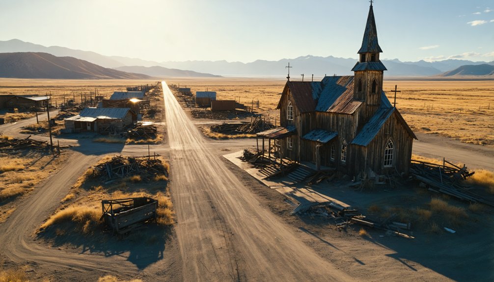
You’ll find exceptional drone photography opportunities at several Mountain West ghost towns. Crystal Mill and St. Elmo in Colorado offer dramatic high-altitude compositions, while Bodie, California showcases over 2,000 preserved gold rush structures. Goldfield, Nevada and Animas Forks present compelling architectural subjects against stark natural backdrops. For ideal shots, plan your flights during golden hour when the light reveals weathered textures and creates dramatic shadows. These remote locations hold countless hidden stories waiting to be captured from above.
Key Takeaways
- Crystal Mill, Colorado offers dramatic cliffside compositions with vehicle access and preserved mining structures against mountain backdrops.
- Bodie, California features over 2,000 gold rush era buildings, providing extensive aerial photography opportunities in a well-preserved setting.
- Animas Forks combines intact historical structures with dramatic natural scenery, perfect for high-altitude drone photography.
- Cerro Gordo’s silver mining complex in Southern California presents compelling architectural layouts ideal for aerial perspective shots.
- South Pass City, Wyoming showcases layered elevations of original saloons and mines with mountain vistas for diverse drone angles.
Essential Equipment for Mountain Ghost Town Drone Photography
Drone pilots exploring ghost towns in mountainous terrain need specialized equipment to capture compelling aerial imagery while ensuring safe, reliable operation.
You’ll want a drone under 250g for maximum flexibility, but with enough power to handle high-altitude winds above 7,000 feet. Look for platforms featuring at least 20MP cameras with excellent dynamic range to capture weathered textures in challenging light.
Smart battery management becomes essential in the mountains. Pack a minimum of three batteries per planned flight session and protect them from cold temperatures using insulated pouches. Unpredictable weather like snow in August can dramatically impact flight conditions and battery performance.
Cold weather rapidly drains drone batteries in mountain environments, so bring extras and keep them warm with insulation between flights.
You’ll also need a portable power station (500-2000Wh) for field charging. Choose multi-constellation GNSS-equipped drones with RTK capability to maintain reliable positioning in deep valleys and canyons. Pay attention to any posted no drone signs at tourist attractions to ensure legal compliance and respect for historical sites.
Weather and Seasonal Considerations for Aerial Shots
While mountain ghost towns offer stunning photographic opportunities year-round, each season presents unique challenges and advantages for aerial imaging.
Winter delivers exceptional seasonal visibility with snow-covered structures contrasting against dark backgrounds, though you’ll need to manage reduced battery life in cold temperatures. Like the city of Vorkuta where minus-60 degrees Fahrenheit temperatures create dramatic frozen landscapes, extreme winter conditions require careful planning.
Autumn’s golden larches and aspens create vibrant compositions perfect for dramatic aerial shots, but watch for increasing wind effects as seasons change. NBC Montana Sky Team captured stunning footage showcasing this seasonal beauty at Garnet Ghost Town.
You’ll face stronger turbulence near ridges and canyons during summer monsoons, though these conditions can yield spectacular storm-lit scenes.
Launch during early morning or late afternoon to minimize thermal activity, and always monitor local wind forecasts.
For winter flights, pre-warm your batteries and keep spares insulated – the cold can cut your flight time by half at high elevations.
Legal Guidelines and Permitting Requirements
Before planning your ghost town aerial photography adventure, you’ll need to navigate a complex web of federal, state, and local regulations that govern drone operations.
Start by ensuring you have your Part 107 remote pilot certificate and proper drone registration if your aircraft weighs more than 0.55 pounds. Your drone must also comply with Remote ID requirements unless flying in an FAA-authorized area. Staying up to date with FAA drone laws is essential for maintaining compliance.
Many ghost towns sit on federal lands, requiring specific permits. If you’re shooting in areas managed by the BLM or Forest Service, you’ll need commercial filming permits. Government employees will need to operate under either a Certificate of Authorization or Part 107 rules.
State parks demand their own permits, often requiring 30-60 days for approval.
Don’t forget to check local ordinances and property boundaries – ghost towns may cross multiple jurisdictions, each with its own drone regulations and permit applications.
Top Mountain West Ghost Towns With Drone Access
When you’re planning to photograph ghost towns by drone, you’ll need to carefully consider both accessibility and photographic potential at each location.
Colorado’s Crystal Mill and St. Elmo offer dramatic high-altitude compositions with relatively straightforward vehicle access, while Nevada’s Goldfield presents compelling architectural subjects in a more accessible desert setting. Modern drone and GIS technology has revolutionized how these historic sites can be documented and preserved.
You’ll find the most rewarding shots at sites that combine preserved structures with dramatic natural backdrops, such as Animas Forks’ alpine valley setting or South Pass City’s historic district nestled in the Wyoming mountains. Cerro Gordo in Southern California offers unique opportunities to capture silver mining heritage through aerial photography.
Ghost Town Access Requirements
Since many ghost towns in the Mountain West sit on a mix of public lands, you’ll need to navigate a complex web of drone regulations before launching your aerial photography mission.
Most ghost town regulations require staying under 400 feet and maintaining visual line-of-sight with your drone. If you’re exploring BLM lands, you can only launch and land on designated routes, while National Forest sites allow drone flights except in wilderness areas. Remember that violations of drone regulations can result in steep fines up to $5,000.
Watch for ghost towns near National Parks, as drone flights are completely banned there. Check tfr.faa.gov for temporary flight restrictions, stay 5 miles from airports, and avoid controlled airspace.
For ideal drone accessibility, scout your launch sites in advance and respect other visitors by steering clear of populated areas like campgrounds and trailheads. The unpredictable weather patterns in mountain regions require checking forecasts thoroughly before planning your ghost town photo session.
Most Photogenic Mining Towns
Among the countless abandoned settlements dotting the Mountain West, five ghost towns stand out as premier destinations for drone photographers.
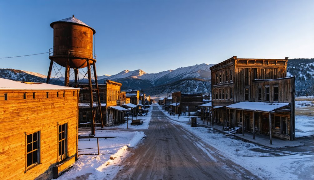
You’ll find spectacular photogenic angles at Bodie, California, where over 2,000 buildings once housed 10,000 residents during the gold rush.
Montana’s Garnet offers 30 intact structures against rugged mountain terrain, while St. Elmo, Colorado rewards drone composition with preserved main streets and mountain backdrops.
South Pass City, Wyoming presents layered elevation shots of original saloons and mines amid the Wind River Mountains.
For stark desert contrasts, explore Silver Reef, Utah, where sandstone formations and mining remnants create compelling aerial perspectives.
Each location delivers unique opportunities to capture the scale and isolation of these forgotten boomtowns from above.
Capturing Historic Architecture From Above

When you’re photographing ghost town architecture from above, you’ll want to position your drone to frame distinctive structural elements like Crystal Mill’s dramatic cliffside perch or Thunder Mountain’s folk-art assemblages against their natural backdrops.
The interplay of light and shadow becomes particularly striking during golden hour, as seen in the way sunlight catches the weathered walls of Animas Forks’ buildings against snow-capped peaks.
Your aerial perspective lets you capture the full layout of these historic sites, revealing how structures like Cerro Gordo’s mining complex and Perkinsville’s ranch buildings were thoughtfully arranged within their challenging terrain.
Framing Structural Design Elements
As you hover your drone above a historic ghost town, the architectural elements below tell compelling stories through careful composition and framing.
You’ll want to position key structural features using the rule-of-thirds, letting roof lines and old railbeds create natural leading lines that draw attention to focal points. For ideal aerial composition, use the negative space of cleared lots to isolate important buildings and emphasize their decay.
When focusing on structural emphasis, capture the distinct profiles of gabled or hipped roofs, noting how chimneys and foundation outlines reveal construction evolution.
Position your drone to highlight porches and stairs that hint at past social spaces. Don’t forget to include outbuildings – they’re essential for understanding site chronology and function.
Fly at lower altitudes for detailed textures, but always maintain safe distances from unstable structures.
Lighting and Shadow Interplay
Natural lighting transforms ghost town photography into an art of timing and patience, especially during the magical change from dusk to nightfall.
You’ll discover remarkable shadow dynamics at Crystal Mill, where the full moon rises perfectly at dusk, casting ethereal glows across the 1893 power plant perched on its rocky outcrop.
For stunning lighting techniques, head to Animus Forks at 11,000 feet, where mountain shadows create dramatic depth on century-old structures.
In Arizona’s Perkinsville, your drone can capture stark contrasts between red rock and verdant hills, while Jerome’s azure skies sharpen midday shadows on historic ruins.
Time your shoots during golden hour when the sun’s low angle intensifies architectural details, or use pre-dusk artificial lighting to soften waterfall shadows and highlight structural elements.
Bird’s Eye Building Layouts
Aerial perspectives expose a domain of hidden patterns in ghost town architecture that ground-level photography can’t disclose.
You’ll want to seek out sites with concentrated building clusters and distinct rooflines, where orthogonal street grids create clear geometric compositions from above.
For ideal layout interpretation, fly gridded patterns at consistent altitudes while maintaining 60-80% image overlap. This approach supports photogrammetry techniques that’ll transform your captures into precise orthomosaic maps.
Position your drone directly above ridgelines and roof intersections, combining nadir shots with oblique spirals to capture both plan views and architectural details.
Choose locations at moderate elevations with open terrain, and always place ground control points near key structures.
You’ll achieve the clearest results using high-resolution sensors and shooting in RAW at fast shutter speeds.
Best Times of Day for Ghost Town Aerial Photography
When photographing ghost towns from above, timing your drone flights around the golden hour can transform an ordinary aerial shoot into something extraordinary. The warm light and long shadows just after sunrise or before sunset create depth and texture across weathered buildings and forgotten streets.
- Golden hour offers ideal 30-60 minute windows for capturing rich textures and dramatic shadows with minimal exposure challenges.
- Blue hour lets you blend twilight’s cool tones with any remaining artificial lights for moody aerial compositions.
- Mid-morning provides clearer visibility and gentler contrast while avoiding harsh midday shadows.
- Early morning often brings calmer winds in mountain valleys, making it easier to capture steady footage.
Don’t limit yourself to sunset shots – each time of day presents unique opportunities to capture these historic sites from perspectives few others will ever see.
Technical Tips for High-Altitude Drone Operations
Although operating drones at higher altitudes opens up stunning photographic possibilities, you’ll need to master several technical considerations to capture ghost towns effectively from above.
When facing high altitude challenges, keep your ISO between 100-400 during daylight hours and maintain a minimum shutter speed of 1/500 to prevent blur. Your drone’s 3-axis gimbal will prove essential for stabilizing shots in mountain winds.
While many consumer drones can technically reach impressive heights, remember to stay within the FAA’s 400-foot limit unless you’ve secured special authorization.
Set your aperture between f/5.6 and f/8 for ideal landscape sharpness, and utilize your drone’s barometric sensors and GPS to maintain precise positioning. These settings will maximize your drone performance while capturing those sweeping views of abandoned settlements.
Safety Protocols for Remote Location Filming
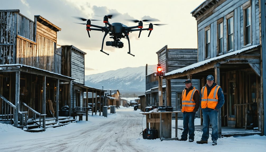
Operating drones in remote ghost towns requires meticulous safety planning before you even reach the site.
Start with a thorough risk assessment to identify potential hazards and establish clear emergency protocols. You’ll need to brief your crew on specific roles and safety measures while maintaining strict control over your operation zone.
Before launching your drone, guarantee you’ve completed these essential steps:
- Secure written permissions from landowners and verify all FAA credentials
- Scout the area on foot to mark safe takeoff zones and identify hazards like unstable structures
- Set up a clear exclusion zone and assign spotters to maintain visual line of sight
- Equip your crew with appropriate PPE and establish emergency communication signals
Frequently Asked Questions
How Do Local Residents Feel About Drones Filming Near Their Mountain Communities?
You’ll find local opinions are often negative, with community concerns focusing on privacy invasion, noise disruption, and safety risks to historic sites. Residents especially value their solitude and prefer advance notification of flights.
Are There Guided Ghost Town Drone Photography Tours Available in These Areas?
Like gold dust in the Rockies, guided drone tours are rare. You’ll find Action Photo Tours’ Utah Badlands workshop, but most ghost towns require checking local photography regulations before launching your drone.
What Wildlife Encounters Should Drone Operators Prepare for at These Sites?
You’ll need to watch for mountain lions at dusk, black bears near trails, rattlesnakes in rocky areas, and territorial birds of prey – all requiring careful wildlife interactions and drone safety protocols.
Can Drone Footage Be Sold Commercially From These Ghost Town Locations?
Like John’s successful ghost town print sales, you’ll need a Part 107 license to sell footage commercially. Drone regulations classify any profit-making activities as commercial operations requiring proper FAA certification.
How Accurate Are GPS Coordinates for Reaching These Remote Ghost Towns?
You’ll find GPS reliability varies widely in remote mountain locations, with accuracy ranging from 3-50+ meters. For best remote navigation results, cross-reference multiple sources and use RTK-enabled receivers.
References
- https://www.youtube.com/watch?v=-LCgefAbZXM
- https://www.youtube.com/watch?v=TwtfLGGhUsA&vl=en
- https://videohive.net/item/drone-aerial-of-a-old-west-ghost-town-in-the-mountains-/57747599
- https://mike-butler.com/crystal-mill-colorado_ghost_town/
- https://www.youtube.com/watch?v=pGPjU65CHeE
- https://www.youtube.com/watch?v=3HsYehzzim0
- https://stock.adobe.com/search?k=old+west+ghost+town
- https://www.youtube.com/playlist?list=PLVbf6aMq-JKHzNIUtsSlF97r5gV5qCGAz
- https://www.youtube.com/watch?v=zZCshjt6HYU
- https://blog.annemckinnell.com/2014/05/08/light-painting-ghost-town/


