You’ll find exceptional drone photography opportunities at Livermore’s historic mill ruins, where 1880s stone foundations and circular processing areas create compelling aerial compositions. Monson’s 17,000-acre colonial settlement offers dramatic stone wall patterns and preserved cellar holes, including the 1756 Gould House. The Russell-Colbath House in the White Mountains provides stunning facade shots against mountain backdrops. These abandoned settlements reveal their full dramatic potential during golden hour flights at 50-200ft elevations.
Key Takeaways
- Livermore ghost town offers dramatic mill foundations, steam engine remnants, and circular processing structures perfect for overhead drone shots.
- Monson’s 280-acre abandoned settlement features colonial stone walls and seven cellar holes ideal for aerial mapping.
- Crawford Notch’s abandoned settlements against stark granite walls provide stunning golden hour photography opportunities.
- The Russell-Colbath House area combines historic architecture with mountain backdrops for compelling aerial compositions.
- Nancy Brook Scenic Area’s ghost town remnants include old store cellars and waterfalls for diverse drone photography angles.
Discovering Livermore’s Hidden Mill Foundations
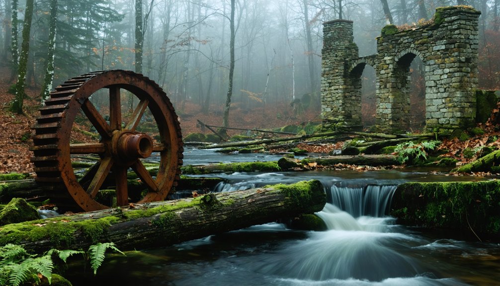
Three distinct foundation complexes from Livermore’s historic mill operations offer drone photographers exceptional opportunities to capture New England’s industrial past.
You’ll spot the main mill’s stone and brick foundations, which housed a powerful 150-horsepower steam engine and five boilers in their 1880s heyday.
The diatomaceous earth processing required immense heat from multiple kilns, leaving behind distinctive circular foundations perfect for overhead shots.
For unique aerial perspectives, navigate your drone along the East Pond shoreline to capture submerged timbers and penstock remnants from the Tripoli mining era.
The hidden foundations of worker housing create compelling geometric patterns when shot from above, while the surviving railroad bed and bridge abutments provide strong linear elements for composition.
The devastating November 1927 flooding permanently altered the landscape, leaving behind haunting ruins that make for dramatic aerial imagery.
Don’t miss the industrial pipeline traces near the Tripoli operation – these 4-inch pipes create striking patterns that really pop in oblique drone shots.
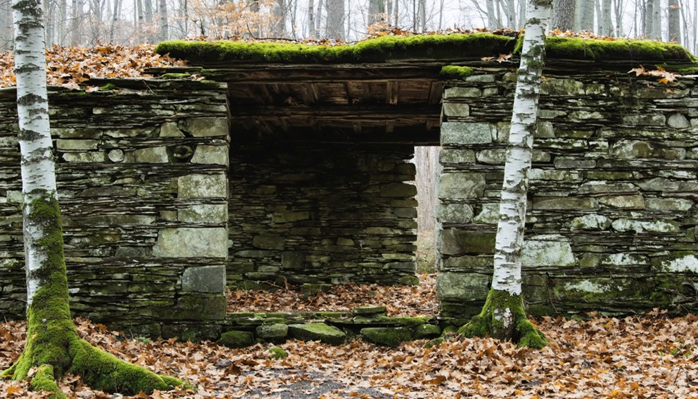
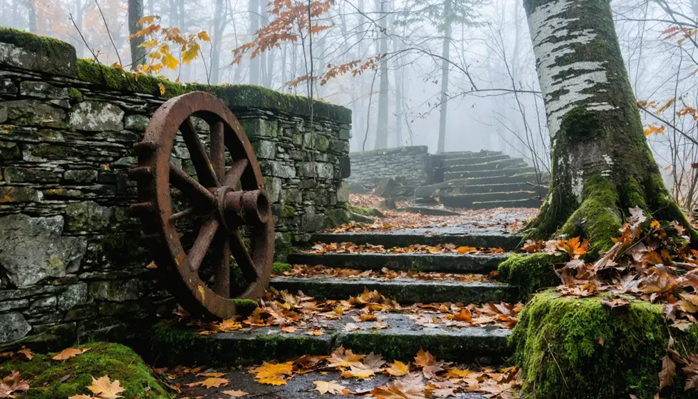
Monson’s Historic Stone Walls and Cellars
You’ll capture stunning aerial perspectives of Monson’s extensive network of colonial stone walls and cellar holes using your drone’s mapping features to document the preserved 17,000-acre settlement layout.
Your drone’s GPS tracking will help record precise locations of the remaining foundations, including Thomas Nevins Jr.’s homestead and the historic Gould House that serves as today’s museum.
Modern archaeologists use red light headlamps during nighttime excavations to protect light-sensitive samples while documenting the site.
While hovering above the trails that follow original colonial roads, you can utilize your drone’s 4K camera to reveal architectural details of the stone-lined cellar holes that tell stories of the village’s mysterious 1770s abandonment.
The Society for Protection stepped in to preserve this historical treasure in 1998 when development threatened to destroy these irreplaceable archaeological remnants.
Mapped Historic Property Layout
Located in modern-day New Hampshire, the abandoned settlement of Monson offers drone photographers an expansive 280-acre canvas of meticulously preserved colonial infrastructure.
You’ll find seven strategically positioned cellar holes, including the restored Gould House museum from 1756, marking the archaeological significance of this pre-Revolutionary site.
Your drone can trace the network of original stone walls that crisscross open meadows, following the historic E. Monson and W. Monson roads.
The property’s preservation efforts have maintained a 3-mile trail system that connects key features like the 1746 town pound and a beaver wetland with heron rookery.
For ideal aerial compositions, you’ll want to capture the interplay between the mapped wall systems and cellar foundations, particularly during golden hour when shadows accentuate the site’s geometric colonial layout.
This remarkable site has remained undisturbed for 200 years, providing photographers with an authentic glimpse into early colonial New England life.
The site’s enduring appeal is highlighted by its mountain laurel blooms that create stunning aerial views each June.
Stone Wall Preservation Methods
While capturing Monson’s historic stone walls through your drone’s lens, proper preservation methods confirm these colonial structures remain intact for future documentation.
You’ll want to focus on two critical aspects: mortar selection and drainage solutions. For mortar repairs, use lime-based options rather than Portland cement – they’re more breathable and won’t trap moisture that leads to stone damage. Regular probing techniques similar to dendrochronological sampling help assess the condition of these historic walls. Test small areas first to confirm compatibility with the historic material. Sulfation removal may be necessary in areas exposed to urban pollution.
Your drone shots will reveal drainage patterns around these walls, so pay attention to proper grading that directs water away from the foundations.
When you spot biological growth during aerial surveys, recommend gentle water-based cleaning methods and avoid high-pressure washing that could compromise the stone’s integrity.
Through careful preservation, you’re helping document and protect these irreplaceable colonial boundaries.
Revealing Cellar Hole Stories
Through your drone’s aerial perspective, Monson’s 18th-century cellar holes reveal themselves as rectangular stone-lined depressions marking the footprints of colonial homesteads.
You’ll spot distinctive fieldstone walls and foundations that tell the stories of settlers like the Wallingford, Bailey, and Nevins families who lived here from 1730-1770.
Your drone’s camera can capture the detailed cellar hole architecture, including locally quarried stone walls and hearth remnants, best visible during leaf-off seasons.
Each depression holds genealogical narratives, now documented on interpretive panels throughout the 200-acre historic park.
For ideal shots, fly during morning or evening golden hours when shadows accentuate the depth of these archaeological features.
The restored Gould House (c.1756) serves as your primary landmark and provides essential context for mapping these preserved colonial foundations.
The harsh conditions of inland colonial life ultimately led to the town’s abandonment by 1770, leaving these stone remnants as silent witnesses to early settlement challenges.
The site’s only public structure was a pound for stray cattle, reflecting the agricultural challenges faced by early settlers.
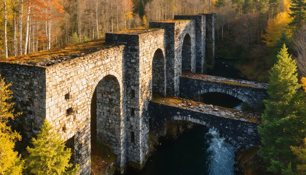
Capturing Livermore Falls Mill at Golden Hour
During golden hour, Livermore Falls Mill transforms into a photographer’s paradise as warm sunlight bathes its weathered structures and illuminates the surrounding White Mountain foliage.
As dusk approaches, sunlight dances across crumbling stone walls, turning this historic mill into nature’s masterpiece.
You’ll want to position your drone to capture the interplay between light and shadow across the multi-level mill ruins, where filtered river water still flows through broken sections and ancient turbines.
Launch your drone above the 103-foot gorge to document the fallen Pumpkin Seed Bridge, its rare inverted double-bowed design now resting in the depths below.
The late afternoon light perfectly highlights the unconventional water redirection systems and decades of natural reclamation.
For the most dramatic shots, hover your drone near the elevated sections, where you can frame both the historic foundations and the rushing falls against the golden-lit forest canopy.
Hearts Location: Gateway to Abandoned Settlements

As New Hampshire’s smallest town by population, Hart’s Location serves as your strategic launch point for documenting numerous abandoned settlements nestled within Crawford Notch.
Exploring the best ghost towns in New Hampshire can lead you to fascinating remnants of the past. Each abandoned site tells a unique story, offering a glimpse into the lives of those who once called these places home. Be sure to take your camera, as the haunting beauty of these locations is truly captivating.
This historic gateway offers unparalleled drone access to forgotten communities, from the ruins of Livermore’s mill town to Monson’s stone-lined cellar holes.
- Position your drone at Sawyer River Road’s pullouts for compelling low-oblique shots of foundation clusters against dense forest.
- Capture orthographic (90°) frames during early morning hours to reveal hidden settlement patterns through tree canopy gaps.
- Follow old rail corridors at 200ft altitude for dramatic wide-angle perspectives of abandoned worker housing.
- Execute detail passes at 50ft elevation around isolated chimney remains and millstone fragments for texture-rich architectural studies.
Your flight planning should prioritize golden hour timing when stone walls cast long shadows, perfect for highlighting geometric patterns.
Passaconaway’s Russell-Colbath House From Above
You’ll need special permission to fly your drone over this historic 1830s homestead, where local legend claims Thomas Colbath’s wife kept a lantern burning in the window for 39 years awaiting his return.
Your aerial gear can capture the stark shift from the valley’s former 95% farmland to today’s forested expanse, showcasing the isolated Russell-Colbath House as the sole surviving 19th-century structure.
Position your drone to frame the symmetrical five-bay facade against the White Mountains backdrop, while including the 2003 post-and-beam barn that complements the historic interpretation of this remote settler’s life.
Lantern Legend Lives On
Though time has weathered its clapboard exterior, the historic Russell-Colbath House stands proudly along New Hampshire’s Kancamagus Highway as the last surviving 19th-century homestead in the Swift River valley.
You’ll want to capture this haunting location where lantern sightings have sparked local ghost stories, particularly around dusk when your drone’s sensors can detect subtle light variations.
The property’s rich history provides exceptional shooting opportunities:
- The symmetrical five-bay facade with its center entrance offers perfect framing for aerial compositions
- The newly constructed post-and-beam barn provides striking contrast against the original structure
- The east barn location near the Austin George homestead creates compelling depth perspective
- The surrounding White Mountain National Forest delivers dramatic natural backdrops year-round
Aerial Views Worth Permission
Getting permission from the US Forest Service opens up remarkable aerial composition opportunities at the Russell-Colbath House.
You’ll capture the homestead’s isolation amid White Mountain National Forest, where the structure’s symmetrical five-bay facade creates striking geometrical patterns from above. Frame your shots to include the 2003 timber barn and historic gravesite, which add depth to your aerial photography techniques.
Position your drone to showcase how this preserved 1.5-story homestead stands as the last remnant of Passaconaway’s farming era, when 95% of the Swift River Valley was farmland.
The Kancamagus Highway’s winding path and surrounding brooks offer natural leading lines for historical site preservation documentation. Consider dawn or dusk flights when the central chimney casts dramatic shadows across the clapboard exterior.
The Haunting Beauty of Crawford Notch

While Crawford Notch‘s stark granite walls command attention from any angle, drone photographers will find its most compelling shots arise from the haunting historical landmarks scattered throughout this White Mountain pass.
You’ll discover rich opportunities for capturing both natural drama and historical resonance, particularly during golden hour when shadows play across abandoned foundations and weathered structures.
- Position your drone above Livermore’s remnants for revealing shots of the old General Store’s cellar and historic safe.
- Capture Nancy Brook Scenic Area’s cascading waters where Nancy Barton’s tragic tale unfolded.
- Frame the preserved Willey House against the devastating rockslide path that split above it.
- Track the legendary Crawford Path from above, documenting centuries-old hiking routes and forgotten settlements.
For best results, mount a polarizing filter to cut glare from streams and enhance the moody atmosphere of these historic sites.
Frequently Asked Questions
Are Permits Required for Drone Photography in New Hampshire Ghost Towns?
You’ll need permits for drone photography in ghost towns on federal lands, plus property owner permission on private sites. Always check drone regulations and photography ethics before launching your aerial shoot.
What Is the Best Drone Equipment for Photographing Historic Ruins?
You’ll get ideal ruin photography using the DJI Phantom 4 RTK’s 20MP camera with manual settings, or Mavic 3 Enterprise’s 4/3 CMOS sensor for detailed structural capture in low-light conditions.
Which Ghost Towns Are Accessible During Winter Months?
You’ll find winter accessibility at Old Hill Village via snowmobile or dogsled, while Monson Center’s wide trails remain visible under snow. Crawford Notch sites offer year-round access, perfect for snow photography along historic paths.
How Close Can Drones Legally Fly to Abandoned Structures?
You’ll need to maintain a safe distance from abandoned structures, following Part 107 regulations that prohibit flight within enclosed spaces. Keep your drone outside structural boundaries while capturing exterior shots.
What Are the Peak Foliage Dates for Aerial Ghost Town Photography?
Want perfect fall photography timing? You’ll find peak foliage maps showing mid-September through early October for northern sites, while southern ghost towns peak late October. Track elevation-based color progression for ideal shots.
References
- https://www.youtube.com/watch?v=zz1RlLCXqzc
- https://thefrogandpenguinn.blogspot.com/2021/07/a-nh-ghost-town.html
- https://outdoorodyssey.net/2022/11/03/the-haunted-ghost-town-of-livermore-nh/
- https://www.atlasobscura.com/places/monson-new-hampshire
- https://www.youtube.com/watch?v=blAbKoH-S5Q
- https://www.youtube.com/watch?v=7X7TXuB8Pk4
- https://www.visitwhitemountains.com/blog/post/spooky-stories-ghost-towns-and-historic-haunted-spots/
- https://www.whitemountainhistory.org/abandoned-towns/livermore
- https://www.whitemountainhistory.org/livermore-tripoli-company
- https://uphsnh.org/livermore-falls