You’ll find exceptional drone photography opportunities at North Carolina’s most haunting ghost towns. Ghost Town in the Sky offers dramatic mountain vistas and abandoned Americana, while Portsmouth Island showcases pristine 18th-century coastal ruins. Don’t miss Proctor’s submerged structures beneath Fontana Lake or the remote Lost Cove settlement. Remember to secure proper permits, pack weather-resistant equipment, and follow FAA regulations. These forgotten places hold countless untold stories waiting to be captured from above.
Key Takeaways
- Ghost Town in the Sky in Maggie Valley offers dramatic aerial shots of abandoned amusement park structures against stunning mountain backdrops.
- Portsmouth Island provides pristine coastal ghost town photography with well-preserved 18th-century buildings and natural beach landscapes.
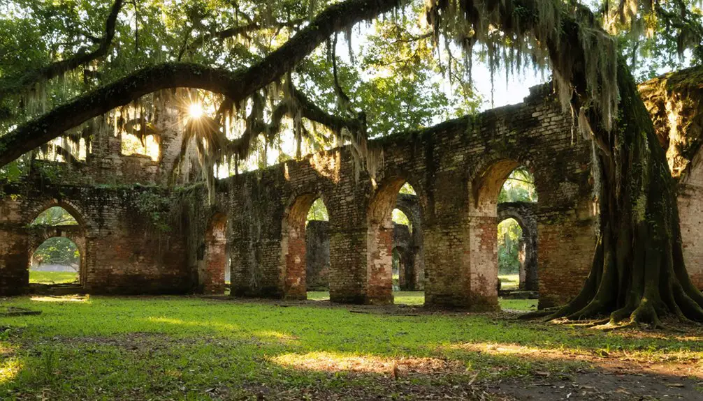
- Brunswick Town features colonial-era ruins and historic structures perfect for drone photography, particularly during golden hour lighting.
- Proctor’s submerged ruins beneath Fontana Lake create unique opportunities for aerial photography when water levels are low.
- Lost Cove’s remote mountain location offers exceptional drone views of abandoned buildings nestled within untouched Appalachian wilderness.
Why Ghost Town Photography Matters in North Carolina
While many photographers focus on capturing North Carolina’s vibrant cityscapes and beaches, the state’s ghost towns offer uniquely compelling subjects for drone photography that document essential chapters of American history.
From Brunswick Town’s colonial ruins to Proctor’s submerged structures beneath Fontana Lake, you’ll discover how these abandoned places reveal North Carolina’s economic evolution and cultural resilience.
The ghost town significance extends beyond mere aesthetics – your aerial shots can help preserve the memory of Lost Cove’s self-sufficient community, Coleridge’s textile heritage, and Elkmont’s mountain resort era. Cultural preservation efforts remain vital to maintaining these historical sites for future generations.
When practicing photography ethics, remember these sites often maintain deep connections to local families through preserved cemeteries and annual traditions. The Decoration Day shuttles organized by the National Park Service help former residents maintain their connection to ancestral burial grounds.
Your drone footage can serve as a powerful tool for documenting these endangered historical treasures before they disappear completely.
Essential Drone Equipment for Abandoned Site Photography
You’ll need rugged, weather-resistant drone equipment that can withstand North Carolina’s unpredictable coastal storms and mountain conditions when photographing abandoned sites.
Your kit should include waterproof cases, silica gel packets, and protective covers to shield sensitive electronics from moisture, dust, and debris common in deteriorating structures. A smart controller with weather resistance can operate reliably in temperatures from 14°F to 104°F while maintaining clear visibility during shoots.
To maintain extended shooting sessions at remote locations, pack a robust portable power station with multiple charging ports, along with solar panels for backup power generation during day-long ghost town documentation. Consider having composite photography equipment to create artistic aerial interpretations while documenting these historic locations.
Durable All-Weather Gear Choices
Successfully photographing ghost towns with drones requires gear that can withstand harsh environments and unpredictable weather conditions.
You’ll need a drone with at least an IP54 rating for basic weather resistance, though IP55 or higher will serve you better in North Carolina’s varied climate. Look for drones that can handle temperatures from -20°C to +50°C and winds up to 17 m/s.
Professional drones like the DJI Matrice 350 excel in these challenging environments thanks to their robust build quality and comprehensive weather protection. Having thermal imaging capabilities is essential for capturing detailed footage in low-light conditions common in abandoned buildings.
Protect your investment with military-spec transport cases and keep your batteries in insulated pouches to maintain performance.
Don’t forget weather-sealed camera housings and hydrophobic lens coatings to combat moisture and dust. Pack a field repair kit with essential tools and spare parts – you’ll appreciate having backup propellers and quick-fix supplies when exploring remote locations.
Remember to use redundant recording methods to safeguard your footage in challenging conditions.
Remote Power Management Systems
Exploring remote ghost towns demands reliable power management systems to keep your drone equipment operational throughout extended photography sessions.
You’ll need portable power stations equipped with solar charging capabilities to guarantee remote charging in these off-grid locations. These units support multiple device charging while enhancing energy conservation through MPPT controllers. The DJI Power 1000 can recharge a digital camera up to 59 times on a single charge.
For extended missions, consider implementing autonomous charging features that enable your drone to detect and land on charging pads automatically. The integration of hybrid power systems combining both electric and fuel-based sources can significantly extend your drone’s flight endurance in these remote locations.
Intelligent battery management systems help stabilize power output and prevent data loss during critical photography moments. You can pair these with solar panels for self-sufficient operations, while tethered drone systems offer unlimited flight time when shooting from a fixed position.
This thorough power setup guarantees uninterrupted coverage of abandoned sites while maintaining peak performance of your photography equipment.
Ghost Town in the Sky: Capturing Mountain Majesty
Perched atop Buck Mountain at a commanding elevation of 4,600 feet, Ghost Town in the Sky presents drone photographers with an unparalleled opportunity to capture both abandoned Americana and sweeping mountain vistas.
The park was originally opened in May 1961 and attracted millions of visitors during its heyday. You’ll find exceptional drone angles along the ridge extending from Cataloochee Divide to the Great Smoky Mountains National Park border. The site’s ghostly aesthetics include 40 authentic Western buildings, complete with original furnishings and eerie animatronics. The park was constructed using 300,000 feet of lumber to create its authentic Wild West atmosphere.
While accessing this private property isn’t permitted, you can capture stunning aerial shots from approved launch zones nearby.
Position your drone to showcase the stark contrast between the decaying structures and the breathtaking mountain backdrop. The site’s unique layout, featuring distinct themed areas like Indian Village and Mining Town, creates compelling compositional opportunities when shot from above.
Portsmouth Island’s Historic Coastal Ruins
Along the remote southern tip of North Carolina’s Outer Banks lies Portsmouth Island, a haunting symbol of maritime history that offers drone photographers rare access to an authentic 18th-century coastal settlement.
The 250-acre historic district showcases compelling architectural styles through its Methodist Church, schoolhouse, and Life-Saving Station – all reflections of the island’s historical significance as a thriving shipping port.
You’ll find excellent drone compositions featuring windswept sandy streets and weathered docks that frame the abandoned buildings. The Methodist Church serves as a striking focal point, while clustered homes reveal the tight-knit community that once lived here.
For the best shots, capture the interplay between harsh barrier island elements and preserved structures at sunrise or sunset when long shadows emphasize the ghost town’s isolation and forgotten grandeur.
Submerged Secrets: Proctor & Hazel Creek Communities
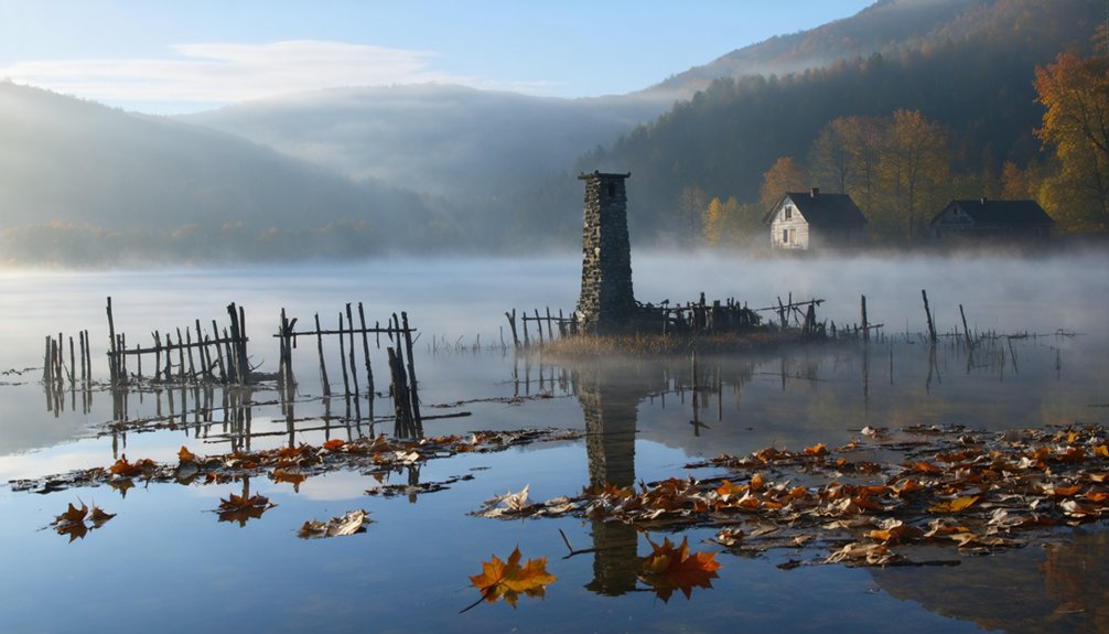
You’ll find the best drone shots of Proctor’s submerged foundations during winter months when TVA lowers Fontana Lake’s water levels by 50-70 feet.
For ideal contrast of the stone ruins against the water, position your drone at 200-400 feet altitude during sunrise when the lake surface acts as a mirror and the morning light creates stark shadows.
Remember to monitor your drone’s battery life carefully in this remote location, as the nearest boat launch is several miles away and cell service is nonexistent.
Hidden Underwater Stone Foundations
Beneath the tranquil waters of Fontana Lake, stone foundations tell the story of Proctor’s submerged past. If you’re an aerial photographer seeking historical significance through underwater exploration, you’ll discover a preserved time capsule of this once-thriving logging community.
During ideal water conditions, your drone can capture:
- Stone foundations of the original homes, general store, and Proctor School visible along the submerged hillsides
- Remnants of the Ritter Lumber Mill operation with its distinctive industrial footprint
- Traces of the old town layout marked by rusted metal and faint road outlines beneath the surface
Remember to obtain necessary permits and maintain safe flying distances.
While the lake holds countless untold stories, some areas contain sensitive archaeological sites and unmoved gravesites requiring respectful documentation from a reasonable altitude.
Seasonal Lake Level Changes
Throughout the year, Fontana Lake’s water levels fluctuate dramatically, revealing hidden glimpses of the submerged Proctor and Hazel Creek communities during winter drawdowns.
You’ll find prime drone photography opportunities when lake level fluctuations expose remnants of the once-thriving settlements, including foundations of the Ritter Lumber Mill and scattered home sites.
During seasonal visibility peaks, you can capture aerial shots of the Calhoun House standing sentinel above the waterline, while the exposed Proctor School foundation offers compelling compositions from above.
Plan your flights when TVA lowers the reservoir, typically in winter months, to document the 26 highland cemeteries and architectural remains.
Remember to maintain line of sight with your drone and respect both National Park Service regulations and the sacred nature of these historical sites.
Dawn Reflection Photography Tips
When dawn breaks over Fontana Lake during civil twilight, the glassy waters create ideal conditions for capturing ethereal reflections of Proctor and Hazel Creek’s submerged structures.
Position your drone 10-20 feet above the calm surface to capture perfect reflection symmetry as the dawn light illuminates remnants of the old communities.
For ideal reflection captures at Proctor:
- Use wide-angle lenses (16-24mm) with ND filters to balance exposure between bright skies and dark water.
- Shoot at 1/60-1/125 shutter speeds while flying parallel to Hazel Creek’s shoreline.
- Time your flights during civil twilight when minimal wind creates mirror-like conditions.
Boost saturation 20-30% in post-processing to enhance orange-blue dawn tones, and selectively sharpen reflection edges while preserving soft sky gradients in your final images.
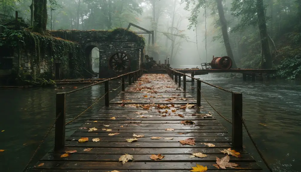
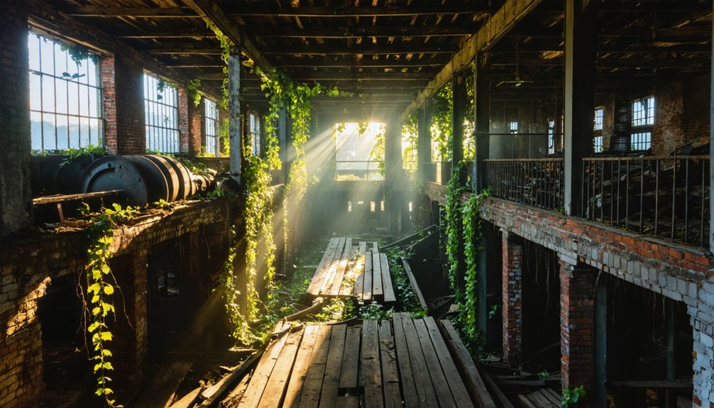
Henry River Mill Village: Industrial Heritage From Above

Rising above the remnants of North Carolina’s textile heritage, Henry River Mill Village presents drone photographers with a compelling blend of industrial archaeology and architectural storytelling. Your drone angles can capture the stark geometry of 35 surviving worker houses, aligned in grid-like formation against the backdrop of dense forest.
Founded in 1903, this abandoned textile complex offers unique historical context through its remaining structures. You’ll find rich compositional opportunities in the weathered foundations of the fire-destroyed mill, the aged dam structure, and the vintage company store.
For ideal visibility, plan your flight during winter months when bare trees reveal more architectural details. While shooting, leverage the site’s leading lines – from old roadways to the Henry River itself – to create dramatic aerial perspectives that showcase this National Register landmark‘s industrial legacy.
Weather and Timing Considerations for Ghost Town Shoots
Successful ghost town drone photography in North Carolina hinges on your careful analysis of seasonal weather patterns and microclimates. Weather impacts vary greatly between coastal and mountain locations, requiring strategic timing to maximize your flight opportunities.
When planning your shots, consider the best locations for astrophotography in North Carolina, as the stunning night skies can offer incredible photographic opportunities. Researching specific sites will help you identify areas with minimal light pollution, which is essential for capturing the beauty of celestial events. Combine this knowledge with optimal weather conditions to enhance your chances of a successful shoot.
Exploring ghost towns for movie shoots can also provide a unique backdrop for creative photography projects. Each abandoned structure tells a story, adding depth and narrative to your visual compositions. Additionally, these locations often attract fewer crowds, allowing for uninterrupted filming and capturing the perfect shot.
Strategic timing and climate awareness are essential for capturing North Carolina’s ghost towns through your drone’s lens.
For ideal shooting conditions, follow these timing strategies:
- Schedule mountain location shoots between May-September when visibility is clearest and thermals are stable.
- Plan coastal ghost town visits during late summer to early fall to avoid marine layer interference and hurricane risks.
- Target golden hour periods for dramatic lighting, especially during summer’s extended daylight hours.
Don’t forget to check local wind forecasts, as ridge-top and coastal locations often experience unpredictable gusts.
After seaside flights, protect your investment with thorough equipment cleaning to prevent salt-spray corrosion damage.

Flying drones at ghost town sites in North Carolina requires careful attention to multiple layers of legal compliance and permissions.
You’ll need FAA registration for drones over 0.55 pounds and Part 107 certification for commercial photography. While NC’s state permit requirement ends December 2024, you must still navigate site-specific restrictions.
Before launching your drone, secure written permission from property owners and check for local restrictions. State parks require special activity permits, while municipal sites often have designated drone zones.
You’ll need to maintain safe distances from prisons and coordinate flights near airports. Remember that capturing images of private individuals or through windows is prohibited.
Document all permissions and maintain proper model releases for commercial shoots to protect yourself from legal issues.
Technical Tips for Capturing Decay and Detail
You’ll want to position your drone during golden hour to capture dramatic shadows that emphasize textural details in deteriorating structures.
Keep your ISO as low as possible while maintaining a minimum 1/60s shutter speed to guarantee sharp capture of surface features like rust, moss, and architectural decay.
When working close to structures, use focus peaking if available, and consider shooting bracketed exposures at multiple altitudes to create richly detailed composite images that preserve both highlights and shadows.
Light and Shadow Play
Light manipulation stands at the forefront of compelling ghost town drone photography, where mastering chiaroscuro techniques can transform ordinary decay into dramatic visual statements.
You’ll discover that strategic positioning of your drone during golden hour creates the perfect balance of light and shadow across abandoned structures.
For maximum impact when capturing ghost town elements, follow these essential shadow techniques:
- Position your drone perpendicular to the sun, allowing deep shadows to form across building facades.
- Expose for highlights to create stark contrast and emphasize structural details.
- Use backlighting to produce dramatic rim effects around deteriorating architecture.
Don’t hesitate to experiment with different angles as the sun moves.
You’ll find that diagonal shadows across decaying buildings add depth, while window-cast patterns create intriguing geometric compositions that tell compelling stories of abandonment.
Equipment and Sensor Settings
Three essential equipment considerations will determine the quality of your ghost town drone photography: sensor size, lens characteristics, and exposure control capabilities.
For peak results, equip your drone with a 1-inch or larger sensor that offers superior dynamic range and low-light performance. Choose lenses with 20-35mm full-frame equivalent FOV and fast apertures (f/2.8-f/4) for versatility.
Proper drone maintenance guarantees your gimbal and stabilization systems perform reliably during critical shoots.
Master exposure bracketing (±1-3 EV) to capture both shadowy interiors and bright exteriors. Maintain shutter speeds above 1/100s to prevent motion blur, and keep ISO as low as possible.
These settings, combined with raw capture and advanced post processing techniques, will help you document decay details while preserving both highlight and shadow information in your ghost town imagery.
Close-Range Composition Techniques
With proper equipment settings dialed in, mastering close-range composition becomes your next challenge in ghost town drone photography.
Successful texture exploration requires deliberate positioning and precise control of your drone at low altitudes. When capturing decay details, you’ll want to maximize visual impact through strategic close range framing.
Follow these essential techniques for compelling results:
- Position your drone at oblique angles (20-60° tilt) to reveal both surface textures and structural geometry in a single frame.
- Use low-altitude passes (30-60 ft) to document window frames, doorways, and material shifts while maintaining context.
- Exploit side-lighting during golden hours to emphasize relief in weathered surfaces, and capture multiple exposures for maximum detail preservation in highlights and shadows.
Remember to maintain slow, controlled movements when flying near structures to guarantee sharp, blur-free captures of fine details.
Safety Protocols for Abandoned Structure Photography
Exploring abandoned structures demands strict adherence to thorough safety protocols that protect both photographers and historic sites.
You’ll need essential safety gear including steel-toed boots, gloves, and respirators to guard against site hazards like rusty nails, broken glass, and harmful particles.
Never venture alone – bring a trusted companion and notify someone of your location and return time.
Before entering any structure, assess its integrity by checking for roof damage, unstable floors, and compromised support beams. If you spot serious structural issues, stay out.
Remember to obtain necessary permissions and research local trespassing laws.
Once inside, maintain situational awareness and respect the site by leaving everything untouched.
Document carefully but prioritize your safety over getting the perfect shot. Your wellbeing matters more than any photograph.
Frequently Asked Questions
How Do You Protect Drone Equipment From Rust in Coastal Ghost Towns?
You’ll prevent rust by applying silicone sprays, storing your drone in airtight containers, using desiccant packs for coastal humidity control, and performing thorough post-flight maintenance with ultrasonic cleaning and dehumidification.
Which Ghost Towns Allow Nighttime Drone Photography for Light Painting Effects?
You’ll hit a wall of nighttime regulations at these sites – none currently permit after-dark drone operations or light painting techniques. Stick to daytime shooting to avoid fines and equipment confiscation.
Are There Guided Drone Photography Tours Available for North Carolina’s Ghost Towns?
You’ll need to book custom aerial photography services, as dedicated ghost town drone guided tours aren’t widely available. Follow FAA drone regulations and obtain proper permits before accessing these historic sites.
What’s the Best Season to Capture Fog Effects Around Mountain Ghost Towns?
Through misty mountain mornings and golden sunrises, you’ll find fall’s your best window. Plan your drone flights from September to November when cool nights meet warm days, creating perfect fog conditions.
Can You Sell Ghost Town Drone Footage to Historical Preservation Organizations?
You can sell your footage through drone licensing agreements to preservation groups, but you’ll need proper permits, documented historical significance, landowner permissions, and high-quality deliverables meeting archival standards.
References
- https://www.onlyinyourstate.com/experiences/north-carolina/ghost-town-nc
- https://www.islands.com/1841384/north-carolina-once-bustling-island-village-ghost-town-pristine-beach-coastal-beauty-portsmouth/
- https://www.romanticasheville.com/ghost_town.htm
- https://www.worldatlas.com/cities/9-quirky-little-towns-in-north-carolina.html
- https://www.atlasobscura.com/places/proctor-lost-ghost-town-hazel-creek
- https://www.youtube.com/watch?v=2OS9ldDK6pM
- https://www.youtube.com/watch?v=8VIDambr27I
- https://www.islands.com/1977921/proctor-north-carolina-great-smoky-mountains-ghost-town-war-history-fishing-destination/
- https://en.wikipedia.org/wiki/List_of_ghost_towns_in_North_Carolina
- https://appalachian.org/lost-cove-ghost-town-in-the-national-forest/