You’ll find Pennsylvania’s most enchanting ghost towns for drone photography in Centralia, where underground fires create eerie landscapes, and Yellow Dog Village, with its moss-covered 1910s worker homes. Don’t miss Eckley’s 200 preserved mining structures or Pithole City’s geometric oil boom ruins. For modern abandonment, head to Frick’s Lock, where 1700s architecture meets nuclear-age desertion. Each site offers unique technical challenges and compelling aerial compositions that reward careful exploration.
Key Takeaways
- Centralia offers dramatic aerial views of abandoned streets, with underground fires creating unique thermal imagery opportunities and stark urban decay scenes.
- Yellow Dog Village presents pristine 1910s architecture with four distinct rows of historic structures and moss-covered roofs ideal for overhead shots.
- Eckley’s Mining Heritage features 200 surviving structures in a 19th-century grid pattern, showcasing Pennsylvania’s rich anthracite mining history.
- Pithole City’s 90-acre landscape reveals geometric patterns of foundation stones and derrick locations, best captured during low-angle sunlight.
- Frick’s Lock provides compelling contrasts between 18th-century abandoned structures, overgrown canal remnants, and a modern nuclear power plant backdrop.
The Underground Inferno: Exploring Centralia From Above
How does a devastating underground mine fire transform a once-thriving coal town into one of Pennsylvania’s most haunting drone photography locations?
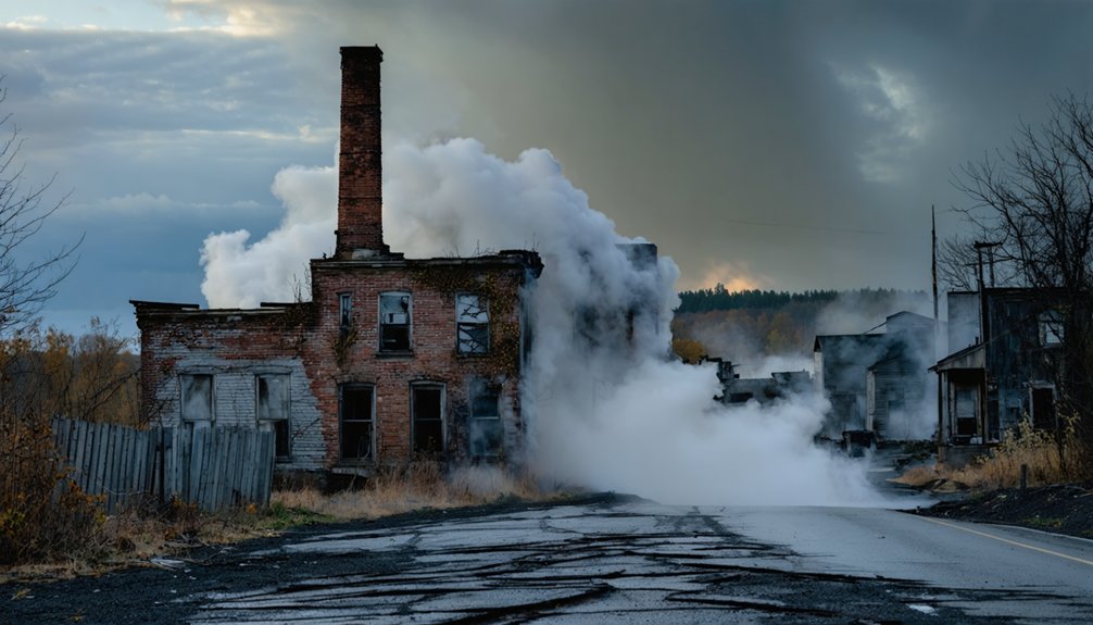
You’ll find your answer hovering above Centralia’s history, where a 1962 trash fire ignited an inferno that still burns through abandoned underground tunnels today.
From your drone’s vantage point, you’ll capture the eerie remnants of this former mining hub, where nearly 3,000 residents once called home.
From above, abandoned streets and empty lots tell silent stories of 3,000 souls who once built their lives here.
Now, with just five inhabitants remaining, nature reclaims the landscape while steam vents and sinkholes punctuate the terrain. Ground temperatures reaching 900 degrees Fahrenheit create dangerous conditions below.
Your aerial footage will reveal empty streets cutting through new-growth forests, the solitary St. Mary’s Church standing sentinel, and the stark contrast of buried sections of Graffiti Highway.
The town’s forced evacuation has left behind a perfectly preserved tableau of urban abandonment. Experts predict the underground coal fire could continue burning for another 250 years, consuming the massive coal seam beneath the town.
Discovering Yellow Dog Village’s Hidden Woodland Architecture
Through Yellow Dog Village’s thick forest canopy, you’ll find drone photography opportunities that capture the haunting interplay between nature and 1910s company town architecture.
Visitors can explore the four distinct rows of historic structures that showcase the original town planning while capturing aerial perspectives of this once-thriving mining community.
Your aerial shots can document the moss-covered roofs and wild vegetation consuming roughly two dozen original worker homes, while revealing the village’s intact historical layout along Buffalo Creek’s eastern slope.
Position your drone strategically above the 32-acre property to frame both the crumbling streets and the prominent mine manager’s house atop the hill, creating compelling compositions that showcase the site’s architectural decay within its woodland setting. Contact the property through Yellow Dog Village Tours to arrange photo permissions and scheduling.
Forest Canopy Drone Angles
While Yellow Dog Village‘s ghostly structures remain hidden beneath a dense forest canopy, drone photography offers unprecedented angles to capture this abandoned mining town’s architectural remnants.
Your aerial perspectives will reveal 90% of the original houses through breaks in the leafy cover, showcasing how nature has reclaimed this 1915 limestone mining settlement. Visitors must pay a $20 entry fee and sign waivers before exploring the historic grounds.
During your woodland exploration, you’ll find ideal drone positions above the tree line where crumbling foundations and deteriorating structures create compelling compositions. The site’s rich history as a limestone mine workers’ community adds layers of cultural significance to every aerial shot.
The site’s current inhabitants – roaming horses, sheep, and other farm animals – add dynamic elements to your overhead shots.
For the most dramatic results, position your drone to capture where the dense woodland meets architectural ruins, highlighting the haunting intersection of civilization and wilderness that makes Yellow Dog Village uniquely photogenic.
Historic Architecture Through Trees
Despite decades of forest encroachment, Yellow Dog Village’s architectural treasures emerge as compelling subjects when viewed through the woodland’s natural frame.
You’ll discover how the interplay of built forms and forest creates striking architectural contrasts, especially during seasonal changes.
Key elements that make Yellow Dog Village uniquely photogenic:
- Worker cottages with limestone walls and wooden porches provide stark geometric forms against organic tree lines
- The chapel’s vertical windows peek through understory gaps, creating natural woodland framing
- Industrial remnants like rail grades and stone piles cut linear paths through the forest canopy
For best results, shoot during golden hour when sunlight filters through the trees, highlighting the contrast between weathered structures and surrounding foliage.
Winter’s bare branches reveal full façades, while autumn colors create dramatic backdrops against the historic masonry.
The village’s Pittsburgh Limestone Corporation origins are evident in the architectural style and building materials used throughout the settlement.
At its peak, the mine’s 3,500 tons daily output supported the development of this photogenic industrial community.
As you venture into Yellow Dog Village‘s densely wooded terrain, you’ll need to strategically position your drone to capture the hidden architectural gems among the thick canopy.
The 32-acre property’s steep topography and narrow valleys along Buffalo Creek create challenging flight paths for aerial navigation.
For ideal woodland exploration, navigate your drone above the dense vegetation that’s consumed the village since the 1950s.
You’ll discover 26 preserved buildings, including the hilltop mine manager’s house and 1920s worker homes, partially concealed by untamed foliage.
The moss-covered roofs and crumbling streets provide compelling aerial compositions, while gaps in the canopy reveal original foundations and vintage pantries below.
Mind the private farm animals grazing in woodland clearings as you document this time capsule of Appalachian mining history.
Today’s drone photographers can capture unique views of homes built for workers of the Pittsburgh Limestone Company in the early 1900s.
Eckley’s Mining Legacy Through a Bird’s Eye View
You’ll find Eckley’s remarkable 19th-century grid pattern laid bare from above, with its 200 surviving structures creating a visual hierarchy from slate-pickers’ shacks to Gothic Revival superintendents’ homes.
The town’s intact street layout reveals the spatial organization of corporate control, where company-owned services cluster along the main thoroughfare amid workers’ housing arranged by occupational status.
Through your drone’s lens, the preserved outbuildings, yards, and paths between structures offer intimate glimpses of daily mining life while documenting the physical remnants of Pennsylvania’s anthracite heritage. Today’s residents who rent from the Commission maintain this living connection to the past.
Preserved Streets From Above
While modern aerial photography has revolutionized ghost town documentation, Eckley’s preserved street pattern offers drone photographers an exceptional window into 1850s mining village design.
The site’s preserved layouts reveal distinct social hierarchies through building placement, with smaller workers’ homes clustered on side streets and grander superintendent residences lining the main thoroughfare.
You’ll discover remarkable aerial patterns that showcase the village’s original design:
- Two parallel main streets form the core grid, creating striking linear compositions
- Dense backlot patterns with outbuildings provide dramatic light and shadow play
- Vegetation-covered lost streets offer intriguing discontinuities perfect for oblique shots
The mile-long “island” footprint, surrounded by mining lands, lets you capture the complete village story in efficient flight segments while highlighting the stark contrast between preserved architecture and natural encroachment.
Historic Buildings Tell Stories
Through your drone’s viewfinder, Eckley’s architectural hierarchy unfolds in remarkable detail, revealing the stark social stratification of 19th-century coal mining life.
You’ll capture the village architecture at its most telling – from the grand Sharpe House at the western end to the humble slate pickers’ dwellings in the east, each structure marking its inhabitants’ place in the mining hierarchy.
Your aerial shots will document the surviving 200 buildings across 100 acres, showcasing the original 1854 town plan.
Key landmarks include the twin church spires of Immaculate Conception and St. James Episcopal, while the weathered company store and mule barn stand as evidence to the village’s mining heritage.
Frame your compositions to highlight the preserved rows of double houses that once sheltered up to 1,000 residents.
Aerial Time Travel: Pithole City’s Oil Boom Remnants
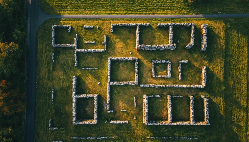
Since its meteoric rise and fall in 1865-66, Pithole City’s remnants offer drone photographers a remarkable window into America’s first major oil boom.
You’ll find a sprawling 90-acre canvas where aerial history comes alive through carefully preserved Pithole ruins, revealing the footprints of what was once Pennsylvania’s third-busiest postal hub.
When capturing this ghost town from above, focus on:
- Dense clusters of foundation stones marking former derrick locations and oil storage yards
- High-contrast earthworks and road traces, best photographed during low sun angles
- Archaeological remains of 54 hotels and an 1,100-seat theater, creating compelling geometric patterns
Your drone’s eye view will reveal striking compositions where sunlight and shadows play across the remnants of this rapid-fire boomtown, which once housed 20,000 souls before fire and economic collapse sealed its fate.
Modern Abandonment: Documenting Frick’s Lock
Because nuclear safety regulations forced its residents to relocate in the 1980s, Frick’s Lock stands frozen in time as a pristine canvas for drone photographers.
You’ll discover abandoned structures dating back to the 1700s, including stone buildings that once bustled with coal trade along the Schuylkill Canal. The site’s historical significance stretches from its origins as a family farm to its heyday shipping over a million tons of coal annually in the 1850s.
Your drone can capture unique angles of this restricted ghost town, where the contrast between decaying 18th-century architecture and the looming Limerick Nuclear Power Plant creates compelling compositions.
Hauntingly juxtaposed against modern nuclear towers, Frick’s Lock’s crumbling colonial ruins offer photographers a stark study in technological progress.
While ground access is limited to occasional historical commission tours, aerial photography offers unrestricted views of the overgrown canal remnants and vacant rooftops that tell this village’s story of industrial evolution and sudden abandonment.
Military Shadows: The Bunker Fields of Alvira
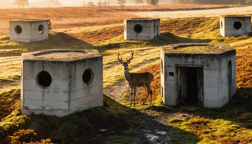
While Pearl Harbor’s aftermath reshaped countless American communities, few transformations match Alvira’s dramatic conversion from pastoral village to military industrial complex.
Today, you’ll find 149 concrete domes scattered throughout State Game Lands 252, perfect for bunker exploration and aerial perspectives.
These haunting remnants of WWII’s Pennsylvania Ordnance Works offer unique drone photography opportunities:
- Earth-covered igloos with thick blast walls designed for upward explosions
- Miles of abandoned railroad beds snaking through dense woodland
- Crumbling foundations marking where 400 residents once lived before the government’s six-week eviction notice
Your drone can capture what ground access can’t – the massive scale of this $50 million complex where families sacrificed their homes for the war effort, never to return despite promises of repurchase rights.
Essential Drone Equipment for Ghost Town Photography
To capture the haunting beauty of Pennsylvania’s abandoned places, you’ll need specialized drone equipment that delivers professional-grade results. A professional-grade camera with a 20MP 1-inch sensor and three-axis gimbal will guarantee sharp, stabilized footage of decaying structures and overgrown landscapes.
Essential drone accessories include ND filters, particularly ND16 and ND32, for managing exposure in varying light conditions. You’ll want multiple high-capacity batteries and spare propellers for extended shooting sessions in remote locations.
Pack ND filters, extra batteries and propellers to ensure successful drone missions exploring remote abandoned sites.
Don’t skimp on storage – high-speed microSD cards are essential for capturing high-resolution panoramas and bracketed shots. Equipment maintenance is critical: invest in a protective carrying case and cleaning kit to safeguard your gear from dust and debris common in abandoned sites.
These tools will help you document Pennsylvania’s forgotten places with precision and artistry.
Seasonal Considerations for Aerial Ghost Town Exploration
Although Pennsylvania’s ghost towns offer year-round drone photography opportunities, each season presents distinct challenges and advantages for aerial exploration.
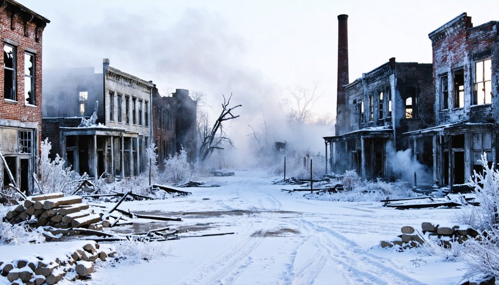
The unique charm of abandoned towns in Pennsylvania captivates photographers, especially during the fall when vibrant foliage contrasts with the remnants of human habitation. In the winter, the snow-covered ruins provide a stark yet beautiful backdrop that highlights their isolation. Each season offers a fresh perspective on these hauntingly beautiful locations, making them a favorite among adventurers and history enthusiasts alike.
You’ll need to carefully plan your flights around seasonal challenges while maximizing excellent conditions for the best aerial shots.
- Early autumn delivers excellent conditions with stable ground, reduced visitor traffic, and sufficient daylight for golden-hour photography, making it your prime window for ghost town exploration.
- Winter’s snow-covered landscapes create striking compositions but limit access to remote sites and require exposure compensation for high-reflectance scenes.
- Spring and summer offer longer flight windows, but you’ll contend with wildlife restrictions, higher humidity affecting image quality, and increased tourist activity that could compromise your shooting freedom.
Consider leaf-on versus leaf-off periods when planning foundation and infrastructure shots.
Safety and Legal Guidelines for Pennsylvania Ghost Town Flights
Before launching your drone at Pennsylvania’s ghost towns, you’ll need to navigate a complex web of federal and state regulations that govern unmanned aircraft operations.
Always carry proof of your FAA registration and TRUST certification for recreational flights, or your Part 107 license for commercial work. Your drone must broadcast Remote ID unless you’re in a designated FRIA.
Stay under 400 feet, maintain visual line of sight, and avoid flying over people or vehicles.
Pennsylvania law specifically prohibits surveillance of private spaces and reckless operations. When shooting ghost towns, conduct thorough preflight site assessments for hazards like unstable structures and overhead wires.
Remember that most state parks restrict drone flights to designated areas, so secure proper authorization before filming abandoned sites on park property.
Frequently Asked Questions
How Close Can Drones Fly to Active Underground Fires in Centralia?
With CO levels 10x higher than safe limits, you’ll need to maintain several dozen meters from vents. Drone safety and fire regulations require staying 100-400 feet high for thermal mapping missions.
Are Night Flights Permitted Over Pennsylvania Ghost Towns?
You can fly your drone at night over Pennsylvania ghost towns if you’ve got anti-collision lighting visible for 3 miles, proper FAA certification, and aren’t violating private property or restricted airspace access.
Which Ghost Towns Require Advance Permits for Commercial Drone Photography?
Through mist-shrouded ruins and forgotten streets, you’ll need commercial permit applications if your ghost town filming location sits within National Park boundaries or state parks, except the six designated drone-friendly parks.
Can Drones Detect Paranormal Activity in Abandoned Pennsylvania Buildings?
While your drone’s sensors can detect physical phenomena during paranormal investigations, they can’t conclusively prove ghost activity. You’ll capture thermal, electromagnetic, and visual anomalies, but these require scientific verification beyond drone technology.
What Wildlife Hazards Should Drone Pilots Watch for at These Locations?
You’ll need to watch for protective raptors attacking drones, bears and coyotes during retrieval, snake-filled ruins, tick-infested brush, and bat colonies that trigger wildlife encounter regulations.
References
- https://www.atlasobscura.com/things-to-do/pennsylvania/ghost-towns
- https://thedronelifenj.com/places-to-fly-a-drone-in-pennsylvania/
- https://www.youtube.com/watch?v=BG993iLPCOg
- https://www.onlyinyourstate.com/trip-ideas/usa/432649
- https://pabucketlist.com/abandoned-places-in-pa-you-can-legally-explore/
- https://www.youtube.com/watch?v=WIiogG9NQxY
- https://www.youtube.com/watch?v=5N-cGFV0LKQ
- https://unchartedlancaster.com/2021/08/08/lidar-imagery-of-safe-harbor-reveals-razed-ghost-town/
- https://triblive.com/local/pittsburgh-allegheny/pittsburgh-ghost-town/
- https://www.legendsofamerica.com/centralia-pennsylvania/


