You’ll find the most enchanting drone photography at Colorado’s high-altitude ghost towns like Animas Forks and Alta Ghost Town. Pack your DJI Mavic 3 CINE with ND filters for stunning 5K captures of weathered structures against dramatic mountain backdrops. Plan your shoots during golden hour at elevations up to 11,800 feet, but watch for rapidly changing weather. Master these remote locations, from the Gold Prince Mill to hidden alpine ruins, and you’ll reveal photography opportunities few have discovered.
Key Takeaways
- Animas Forks offers nine well-preserved buildings and the Gold Prince Mill against dramatic San Juan Mountain backdrops at 11,200 feet.
- Alta Ghost Town provides exceptional drone shots of weathered mining structures against 11,800-foot alpine peaks during golden hour.
- Lulu City features historic log cabins naturally blending with forest canopies, ideal for aerial photography in early autumn.
- Alta Lakes area combines reflective water surfaces with collapsed cabins, creating unique geometric patterns visible from above.
- The Animas River corridor near Animas Forks provides sweeping valley perspectives while maintaining safe 100-foot distances from structures.
Essential Drone Photography Equipment and Safety
While ghost town photography demands skill and artistry, your drone equipment setup serves as the foundation for capturing these historic mountain ruins safely and legally.
A thoughtfully equipped drone setup is essential for safely documenting abandoned mountain settlements while respecting preservation guidelines and regulations.
You’ll need a primary drone with a stabilized 20MP/4K camera, plus ND filters for managing bright mountain light. The DJI Mavic 3 CINE excels at capturing expansive landscape shots of ghost town ruins with its 5K resolution capabilities. A 360-degree propeller guard provides essential protection when navigating near structures and obstacles. Pack at least two spare batteries and high-speed microSD cards rated for 4K capture.
Don’t forget your photography regulations compliance kit – Remote ID equipment, documentation, and anti-collision lights are non-negotiable.
For equipment maintenance in remote locations, bring a multi-bay charger, insulated battery storage, and an organized spares kit. A rugged carry case protects your gear during trail transport, while a ground camera with tripod lets you complement aerial shots with detailed perspectives from below.
Finding the Perfect Light: Best Times to Shoot Ghost Towns
When should you launch your drone to capture the soul of an abandoned mountain settlement? Your prime window is golden hour, when the low sun angle creates dramatic shadows that reveal hidden architectural details and textures on weathered surfaces.
Similar to photographing the Maroon Bells at sunrise, capturing ghost towns during early morning provides optimal lighting conditions. The warm directional light enhances tonal separation while minimizing harsh contrasts between bright skies and dark interiors.
Don’t overlook blue hour‘s potential – this twilight period offers balanced exposure conditions for capturing illuminated interiors against the ambient exterior light. Plan your visits during early autumn months when vibrant foliage adds stunning color contrast to the weathered structures.
For advanced pilots, night flights yield opportunities for epic long-exposure composites with starfields and creative light-painting, though they require strict legal compliance and careful planning.
While midday conditions work best for mapping flights, they’ll challenge your dynamic range handling with deep shadows and blown highlights.
Consider overcast conditions for detail-rich architectural documentation.
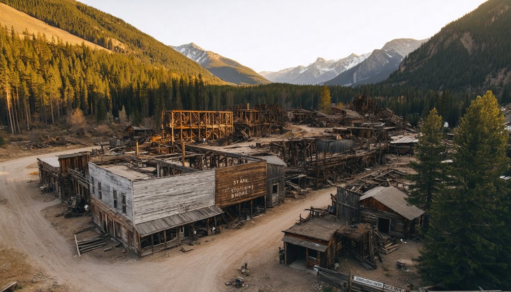
Top Aerial Photography Locations in Animas Forks
A ghost town photographer’s paradise awaits at Animas Forks, perched at 11,200 feet in Colorado’s San Juan Mountains.
You’ll find prime aerial shots at the iconic Gold Prince Mill, where your drone can capture the weathered remains against dramatic mountain backdrops. For historic preservation documentation, focus on the nine original buildings, including the jail and Duncan House, which create compelling grid patterns from above. The 12-mile drive from Silverton requires a high-clearance 4×4 vehicle to access this remote location.
Position your drone along the Animas River corridor for sweeping valley perspectives, using the watercourse as a natural leading line. Summer mornings provide optimal conditions for clear skies and visibility.
Don’t miss the opportunity to frame the site against Jones, Niagara, and Crown peaks – but remember to account for high-altitude performance limits and unpredictable mountain weather.
Keep at least 100 feet from structures and always check current BLM regulations before launching.
Crystal City and Crystal Mill: Drone Photography Paradise
Despite its reputation as one of Colorado’s most photogenic ghost towns, Crystal City and its iconic Crystal Mill now enforce strict no-drone policies that’ll reshape your shooting strategy.
You’ll need to master ground-based photography instead, with fees ranging from $10 for basic setups to $200 for exclusive waterfall access.
Located at 8,897 feet elevation, Crystal Mill demands careful planning. Crystal River Jeep Tours offers guided photo excursions from Marble.
You’ll find the best shots around 5pm when the sun dips behind the mountains, and autumn brings colorful aspens that frame the historic structure beautifully.
Pack a wide-angle lens for front-facing compositions and a 24-50mm for side angles.
Access requires maneuvering a challenging 6-mile 4WD trail from Marble, or you can opt for a 5.6-mile hike.
Remember, photography regulations require signing waivers before shooting, and there’s limited wifi – grab forms in advance.
The site’s only accessible from June through mid-October.
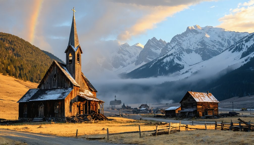
Hidden Gems: Alta Ghost Town and Lulu City From Above
You’ll discover Alta Ghost Town‘s weathered structures set against a dramatic 11,800-foot alpine backdrop, where pioneering AC power once energized the mining operations of the late 1800s.
This historic site, once known as Alta-Gold King, attracted fortune seekers during its gold rush heyday.
Access to this remarkable photography location requires a high-clearance 4×4 to navigate the rugged terrain leading to the site.
Your drone can capture the striking interplay between the remaining cabins, boarding house, and tramway features as they stand sentinel against snow-capped peaks and pristine mountain lakes.
Whether you’re framing low-angle approaches to texture-rich wooden ruins or executing high-altitude panoramas that showcase the site’s historical footprint, you’ll need to account for the thin air’s impact on your drone’s performance and the frequent weather changes at this elevation.
Dramatic Mountain Meeting Points
While many drone photographers flock to well-known Rocky Mountain locations, Alta Ghost Town‘s dramatic meeting point between civilization and wilderness offers stunning aerial compositions at 11,000+ feet.
You’ll capture unique mountain landscapes where weathered structures frame Mt. Wilson through broken windows and doorways, creating natural layers in your shots.
For the most compelling aerial perspectives, plan your flights during golden hour when alpenglow bathes the peaks in warm light, contrasting against the ghost town’s silhouettes.
Position your drone for low passes over intact building frames to reveal the site’s layout against the backdrop of Alta Lakes.
Remember you’re operating in thin air – your drone’s performance will be affected, so maintain conservative flight paths and keep spare batteries warm.
Watch for incoming weather fronts that can add atmospheric drama to your compositions.
Ruins Against Alpine Skies
High above the alpine wilderness, two extraordinary ghost towns beckon drone photographers seeking rare aerial perspectives. At Alta, you’ll find weathered mining structures set against dramatic 11,060-foot peaks, where your drone can capture the perfect interplay between abandoned buildings and pristine alpine lakes.
Meanwhile, Lulu City’s scattered log cabins emerge from dense forest canopies, offering unique compositions of ruins melting into the natural landscape.
You’ll want to time your flights during golden hours when alpenglow bathes these alpine landscapes in surreal light. Your drone’s wide-angle lens will excel at revealing the full scope of these historic settlements, though you’ll need to monitor high-altitude weather conditions carefully.
Both locations reward technical precision with unmatched views of Colorado’s mining heritage against a backdrop of untamed mountain terrain.
Hidden Historical Mining Remnants
Beneath the alpine grandeur lies a photographer’s treasure trove of historical mining remnants at Alta Ghost Town, perched at a breathtaking 11,800 feet.
You’ll discover weathered timber buildings and rusted machinery that tell tales of Colorado’s mining era through your drone’s eye.
From aerial perspectives, these abandoned structures reveal hidden patterns and compositions that ground-based photographers miss:
- The prominent mess hall’s window frames create natural vignettes against mountain backdrops
- Collapsed cabins and foundations form geometric patterns visible only from above
- Historic roads and ditches create leading lines that guide viewers through the landscape
- Alta Lakes provide mirror-like surfaces to capture structure reflections in your compositions
Pack your high-clearance 4×4 and plan for golden hour shoots when alpenglow illuminates these forgotten relics.
You’ll need to master both digital and analog navigation tools to safely reach remote ghost town locations, as many sites lie beyond cellular coverage in challenging mountain terrain.
Before heading out, load your GPS with offline maps and waypoints while also carrying printed topographic maps and a compass as essential backups for when electronics fail at elevation.
Your specific route planning should account for seasonal access limitations, required vehicle capabilities, and multiple bailout options – particularly when attempting reaches to high-alpine ghost towns where weather and trail conditions can change rapidly.
Safe Routes To Sites
While drone photography in the Rocky Mountains offers stunning rewards, reaching these remote ghost towns demands careful navigation planning and appropriate vehicles. Your route planning must account for challenging terrain and time-intensive travel across dusty, rocky paths that test even seasoned off-road enthusiasts.
For safe driving to these aerial shooting locations:
- Pack a high-clearance 4WD vehicle – Crystal City’s 6-mile stretch and Animas Forks’ 12-mile rocky ascent demand serious off-road capability.
- Follow established routes like County Road 3 near Marble, which syncs with Crystal River for reliable navigation.
- Allow extra hours for rough sections – Alta’s difficulty rating of 3/5 means slower progress than GPS estimates.
- Consider guided access for spots like Lulu City, where local expertise reveals hidden shooting locations.
Equipment For Mountain Access
Maneuvering the Rocky Mountains’ challenging terrain demands specialized equipment that combines high-tech navigation tools with robust outdoor gear.
You’ll need a dual-band GPS device with preloaded topographic maps and high-resolution orthophotos for precise navigation to ghost town sites. Load your essential mountain gear: trekking poles, microspikes, and a helmet for steep approaches over scree and talus.
Pack your drone in a specialized cradle or chest harness to protect it during climbs, and don’t forget waterproof gear bags with silica desiccant packs for electronics protection.
Your access strategies should include a high-clearance vehicle for rough forest roads and a satellite communicator for emergencies. Always verify legal access points using BLM and USFS maps before heading out, and keep paper maps as backup when electronics fail in deep canyons.
Seasonal Trail Conditions
Despite their remote locations, Rocky Mountain ghost towns offer varied accessibility through distinct seasonal trails and routes.
You’ll need to plan your drone shoots around spring accessibility and winter challenges, as elevations above 11,000 feet become snowbound during cold months.
- Crystal City’s 9-mile trail demands 4WD vehicles, especially during summer’s dusty conditions.
- Alta’s rocky path rates 3/5 difficulty but rewards you with prime morning photography angles.
- Animas Forks requires high-clearance vehicles to tackle constant potholes and rock obstacles.
- Mount Falcon offers the easiest access via a 1.5-mile hike, perfect for year-round shooting.
For ideal drone footage, tackle these paths during late spring when snow melts reveal historic structures, but before summer traffic kicks up excessive dust on the trails.
Frequently Asked Questions
Are There Camping Options Near These Ghost Towns for Multi-Day Photo Shoots?
You’ll find dispersed camping opportunities near Animas Forks and along Crystal City’s access route, letting you set up photography gear for multi-day shoots while following local camping regulations in these remote locations.
What Wildlife Encounters Should Photographers Be Prepared for at These Locations?
With bears involved in 90% of wildlife incidents, you’ll need to stay alert for elk, moose, black bears, and mountain lions. Keep 120+ feet away during photography, and don’t leave gear or food unsecured.
Do Any of These Ghost Towns Require Permits or Entrance Fees?
You’ll only need to pay entrance fees at Lulu City since it’s within Rocky Mountain National Park. Animas Forks, Crystal Mill, and Mount Falcon don’t require specific permits or entry costs.
Can You Shoot Drone Footage During Winter Months at These Locations?
Like frozen wings against winter’s bite, you’ll face severe limitations. Your drone won’t handle extreme cold well, roads become impassable, and Lulu City’s completely off-limits due to park drone regulations.
Are There Guided Photography Tours Available to These Ghost Town Sites?
You’ll need to plan your own photo adventures – none of these ghost towns offer official guided tours or photography workshops. Pack your gear and navigate independently through these remote mountain locations.
References
- https://airial.travel/attractions/united-states/animas-forks/animas-forks-ghost-town–nHtWGSb
- https://www.islands.com/1975215/secret-colorado-abandoned-mine-ghost-town-hidden-marble-mountain-waterfall-views-crystal/
- https://www.youtube.com/watch?v=zZCshjt6HYU
- https://www.youtube.com/watch?v=N0mNOeRG-lk
- https://photographerstrailnotes.com/colorado-preview/a-room-wtih-a-view-photographers-guide
- https://mike-butler.com/crystal-mill-colorado_ghost_town/
- https://www.youtube.com/watch?v=_VGfCLKHwNw
- https://pamphotography.blog/2012/07/29/photographing-colorado-ghost-towns/
- https://www.seneca-photography.com/blog/gear-list
- https://www.samys.com/c/Drone-Accessories/3/380.html


