
You’ll find exceptional drone photography opportunities at South Dakota’s most evocative ghost towns. Okaton’s iconic grain elevator and abandoned railroad tracks create striking compositions, while Capa’s arched church windows and scattered foundations offer compelling aerial narratives. Bugtown’s mining remnants and Black Fox’s stone ruins provide dramatic high-altitude shots against the prairie landscape. For ideal results, visit during golden hour when long shadows emphasize textures and architectural details. The hidden stories of these forgotten settlements await your aerial exploration.
Key Takeaways
- Okaton offers stunning aerial compositions of an iconic grain elevator and abandoned Milwaukee Road branch line against prairie landscapes.
- Capa’s arched church windows and scattered brick foundations create compelling visual patterns ideal for drone photography.
- Bugtown features a historic chapel and mine waste piles that cast dramatic shadows during golden-hour flights.
- Black Fox’s stone fireplace ruins and geometric tailings patterns provide unique aerial photography opportunities in the Black Hills.
- Cottonwood’s unobstructed prairie setting allows for dramatic panoramic shots featuring wooden church ruins and an active rail line.
Capturing Okaton’s Railroad Heritage From Above
Okaton’s towering grain elevator stands as a silent sentinel over the abandoned Milwaukee Road branch line, offering drone photographers an iconic subject for capturing South Dakota’s vanishing railroad heritage.
You’ll find compelling compositions by following the abandoned tracks that once connected this 1906 prairie town to essential commerce routes. The weathered wooden elevator, now sporting “Bingo Grain Co.” lettering from a film shoot, creates dramatic shadows during golden hour flights.
Dramatic shadows stretch across rusted rails as Okaton’s old grain elevator stands sentinel over South Dakota’s forgotten prairie commerce routes.
For the best shots, fly low passes at 50-200 feet to capture detailed textures of rotting ties and prairie grass reclaiming the rail bed. The once vibrant community is now a haunting reminder of how quickly prosperity can fade away.
Frame your aerial perspectives to include Interstate 90 in wider shots, highlighting how modern transportation bypassed this once-bustling railroad stop and sealed its fate as a ghost town. The now-quiet streets once bustled with activity from Milwaukee Railroad workers who helped establish the town in 1906.
Aerial Views of Capa’s Abandoned Structures
You’ll find striking compositions through Capa’s arched church windows, where the partially collapsed roof creates dramatic interplays of light and shadow in your aerial shots.
The scattered brick foundations and structural remains provide natural leading lines that’ll guide your drone’s camera movement across the ghost town’s footprint.
The combination of vertical architectural elements and horizontal foundation patterns lets you craft compelling visual narratives about this once-thriving railroad community’s evolution. The town’s establishment as a railroad stop in 1904 marked the beginning of its brief but vibrant history.
The distinctive sight of the old hot mineral bath offers unique aerial photo opportunities, with steaming water creating atmospheric effects against the decaying hotel structure.
Church Windows From Above
Through the ghostly lens of a drone camera, Capa’s abandoned church reveals its haunting architectural details from above.
You’ll capture striking aerial symmetry as your drone hovers over the double-door entrance, while pigeons scatter from their perches in the upper windows. The structure’s weathered walls tell a story of nature’s relentless assault, with wind damage having partially dismantled sections of this century-old sanctuary.
What was once a proud symbol of faith now lies as a pile of rubble, transforming the aerial perspective into a somber testament to time’s destructive force.
For the best shots, you’ll want to position your drone to frame the fenced perimeter that surrounds this piece of abandoned architecture. The town’s historic artesian well bathhouse once drew visitors seeking rejuvenation in these remote plains.
The scattered bed frames and debris near the church add compelling visual elements to your aerial composition. But don’t wait too long – Mother Nature’s persistent decay means these haunting windows won’t be around forever.
Scattered Buildings Tell Stories
A stark assemblage of fourteen structures dots Capa’s prairie landscape, offering drone photographers a compelling aerial canvas of abandonment.
You’ll discover urban decay through collapsed rooflines and weather-worn walls, each building frame telling forgotten narratives from above.
Position your drone to capture the interplay between intact and deteriorating structures. At 30-60 feet, you’ll reveal intimate details through roof gaps, while 200-foot elevations showcase how the buildings punctuate the vast prairie. Like Okaton’s Ghost Town Mall, these abandoned sites provide fascinating glimpses into South Dakota’s past. An abandoned truck and scattered farm equipment provide scale markers against the horizontal expanse.
The town’s signature Catholic church ruins create a dramatic centerpiece for aerial compositions.
Remember to secure property access permissions before flying low. The nine-mile gravel approach from Midland requires careful flight planning, but the remote setting rewards you with uncluttered compositions of South Dakota’s vanishing architectural heritage.
High Prairie Panoramas of Cottonwood

While Cottonwood’s high prairie setting might initially seem stark, its broad grassland mesas create ideal conditions for dramatic panoramic drone photography.
You’ll find unobstructed horizon lines and prairie textures that transform beautifully in golden-hour light, with seasonal wildflowers and prairie dog mounds adding natural depth to your compositions.
Position your drone to capture Cottonwood’s history through its remaining vertical elements – the warped wooden church, brick store ruins, and grain elevator stand as striking focal points against the endless grassland. Many buildings feature distinctive lighter colored brick trim above windows and corners, offering architectural detail in your shots. The town was originally named Ingham before being renamed for Cottonwood Creek.
The active rail line provides compelling leading lines, especially when framed against the area’s renowned cloudscapes. For night shoots, the minimal light pollution reveals stunning Milky Way opportunities.
Remember to launch from public roads near US Highway 14, as most structures sit on private land.
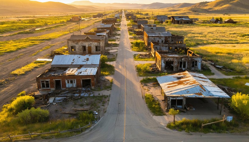
Scenic’s Historical Buildings Through a Bird’s Eye View
Here wheels grazing claude acceptable
Aerial Building Composition Tips
Shooting historic buildings in Scenic from above demands careful attention to compositional elements that showcase the town’s architectural character.
You’ll want to leverage the town’s stark prairie setting and tight building clusters for dramatic aerial compositions. Position your drone to capture leading lines from old roads and rail spurs, directing viewers’ eyes toward key structures. The flat terrain and minimal vegetation create perfect conditions for isolation shots that emphasize the haunting beauty of abandoned buildings.
- Use diagonal drone angles to create dynamic tension with roof ridgelines and shadows
- Frame deteriorated structures within negative prairie space to emphasize scale
- Combine nadir and oblique shots to document structural patterns
- Layer your compositions with building clusters, town core, and prairie backdrop
Railroad Heritage Vantage Points
South Dakota’s railroad heritage comes alive through aerial photography, offering unique perspectives of ghost towns that emerged during the rail expansion era.
As the sun sets over the vast plains, the clear night sky becomes a spectacular canvas for capturing the best locations for astrophotography in South Dakota. The minimal light pollution in these remote areas allows for breathtaking views of the Milky Way, creating a perfect backdrop for photographers seeking to immortalize the beauty of the cosmos. Exploring these sites not only reveals stunning celestial displays but also connects enthusiasts with the state’s rich natural landscapes.
You’ll capture compelling railroad remnants in Claremont, where scattered structures from Detroit’s dissolution dot the prairie, and in Hecla, where rail-era foundations stretch across open fields.
For dramatic ghost town narratives, position your drone above Stratford’s linear layout, where elevator silhouettes pierce the horizon.
White Rock’s tri-state corner location showcases the poignant confluence of river and abandoned rail lines, while Dumont’s northern Black Hills setting reveals hidden cattle pens and section houses amid wooded terrain.
Each site presents distinctive angles for documenting these settlements’ rise and decline through their railroad infrastructure, telling stories of ambitious expansion and eventual abandonment.
The Lost Mining Town: Bugtown From Above
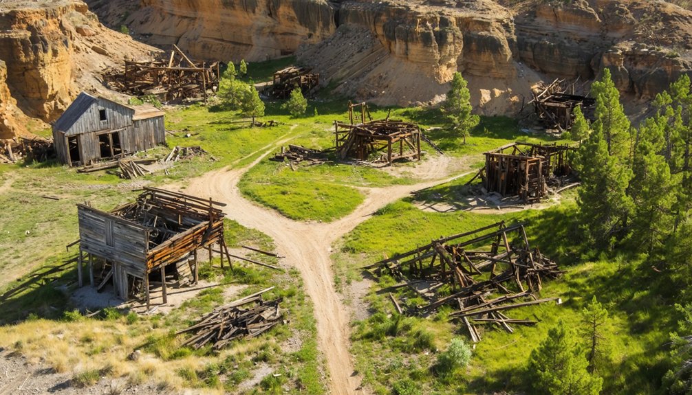
When you fly your drone over Bugtown, you’ll witness the haunting remnants of a once-thriving mining settlement that peaked at 300 residents in the early 1900s.
Like a time capsule frozen in midair, Bugtown’s ghostly ruins whisper stories of 300 souls who once called this mining town home.
Located in the remote Black Hills region, this abandoned town tells its story through aerial views of weathered structures and mining debris. The iconic chapel stands as your primary landmark, while traces of the old post office mark the historic center where Calvin Coolidge once picnicked in 1927.
- Scattered mine waste piles create dramatic shadows during golden hour flights
- Overgrown paths and faded foundations offer compelling geometric patterns
- The isolated chapel provides a stark focal point against the rugged landscape
- Empty family homes reveal the town’s gradual decline since the Great Depression
Black Fox: Documenting a Vanished Settlement
Nestled deep in the Black Hills at nearly 6,000 feet elevation, Black Fox offers drone photographers a challenging yet rewarding canvas of mining history.
You’ll find stone fireplace foundations and scattered ruins that tell the story of this former iron mining settlement near Pactola Lake.
For the best aerial shots, capture the geometric patterns of old tailings and mine cuts contrasting with the forested ridgelines. Low-angle passes over abandoned structures reveal compelling compositions, especially during fall when seasonal colors transform the landscape.
Remember to mix nadir and oblique angles to showcase both detail and context.
Before launching, check National Forest regulations and verify private property boundaries.
Watch for hidden mine shafts when selecting landing zones, and always carry emergency gear in this remote terrain.
Essential Drone Photography Tips for Ghost Towns
Mastering ghost town drone photography requires careful attention to both technical and artistic elements. Before launching your drone, research local regulations and obtain necessary permits for aerial photography. Scout locations using Google Maps to identify compelling compositions and plan your flight paths.
When shooting, focus on capturing the town’s layout and architectural relationships that aren’t visible from ground level.
- Position your drone during golden hours to maximize dramatic shadows and textures
- Frame wide shots that reveal the full scope of abandonment and decay
- Look for leading lines created by old roads and building arrangements
- Combine aerial views with ground-level images for a complete documentary perspective
Remember to maintain safe distances from structures and respect private property boundaries while pursuing unique aerial compositions of these historic sites.
Best Times and Seasons for Ghost Town Aerial Shots
To capture ghost towns at their most atmospheric, timing your drone flights during golden and blue hours yields the most compelling aerial images.
You’ll find the richest shots 30-90 minutes after sunrise or before sunset, when low-angle light creates dramatic shadows across weathered buildings and abandoned streets.
For the clearest footage, launch during early morning golden hour when prairie winds are calmest.
Blue hour’s twilight glow reveals subtler details, with remaining artificial lights adding haunting focal points to your compositions.
Winter flights offer stark contrasts and unobstructed views, though you’ll need to watch battery performance in cold conditions.
Spring and autumn provide unique opportunities – catch first snow dustings or wildflower blooms against ghost town backdrops.
Just remember to check local regulations for twilight operations.
Legal Guidelines for Drone Photography at Historic Sites

Before launching your drone at South Dakota’s ghost towns, you’ll need to navigate a complex web of federal, state, and local regulations designed to protect historic sites.
As you explore these intriguing ghost towns in South Dakota, consider the stories they tell about the frontier spirit and the challenges faced by settlers. Many of these locations are remnants of a once-thriving economy, now silent monuments to a bygone era. Capturing aerial views of the dilapidated structures can provide stunning visuals, but always remain respectful of the historical significance they hold.
Understanding drone regulations while respecting historic preservation guarantees you’ll capture amazing footage without legal troubles.
Follow the rules, honor the history, and your drone footage will soar – legally and beautifully.
- You must stay 400 feet away from designated historic monuments and obtain permits 45 days in advance for protected areas like Deadwood’s historic district.
- Register your drone if it’s over 0.55 pounds and complete TRUST certification for recreational flights.
- Never conduct surveillance of private structures, even in abandoned locations, as it’s a class 1 misdemeanor.
- Keep your drone in visual line of sight, fly below 400 feet altitude, and only operate during daylight hours.
Frequently Asked Questions
Are There Any Dangerous Wildlife to Watch for While Flying Drones?
You’ll need to watch for mountain lions, rattlesnakes, and bison during wildlife encounters. Keep your distance for drone safety, as these animals can become aggressive if they feel threatened.
What Backup Equipment Should I Bring for Remote Ghost Town Locations?
Like a seasoned explorer, pack extra batteries, lens filters, spare props, backup SD cards, and a portable power station. You’ll need redundant gear when you’re miles from civilization.
How Do Local Weather Patterns Affect Drone Battery Life?
You’ll experience shorter battery life in cold temperatures, high winds, and wet conditions. Watch your drone performance closely – winds drain power faster, while freezing temps can reduce capacity by 40%.
Which Ghost Towns Require Special Permits for Commercial Drone Photography?
Like ghosts behind rusted gates, you’ll need permits for commercial photography at any ghost town on state park, NPS, or Forest Service land – including Custer State Park’s abandoned sites.
Can I Sell Prints of Ghost Town Drone Photos Online?
You can sell prints if you’ve got Part 107 certification and proper permissions. Remember copyright considerations, including property releases. Choose platforms like Etsy or POD services for direct-to-consumer ghost town photo sales.
References
- https://www.youtube.com/watch?v=jmSADvq4Lek
- https://www.onlyinyourstate.com/experiences/south-dakota/capa-ghost-town-sd
- https://photobyjohnbo.com/2021/01/26/okaton-south-dakota/
- https://icatchshadows.com/okaton-and-cottonwood-a-photographic-visit-to-two-south-dakota-ghost-towns/
- https://en.wikipedia.org/wiki/List_of_ghost_towns_in_South_Dakota
- https://www.youtube.com/watch?v=_0WNYsFLSLA
- https://www.atlasobscura.com/places/scenic-ghost-town
- https://www.blackhillsbadlands.com/blog/post/old-west-legends-mines-ghost-towns-route-reimagined/
- https://www.travelsouthdakota.com/trip-ideas/abandoned-beauty-ghost-towns-structures-south-dakota
- https://myfamilytravels.com/the-forgotten-railroad-town-in-south-dakota-thats-still-standing/


