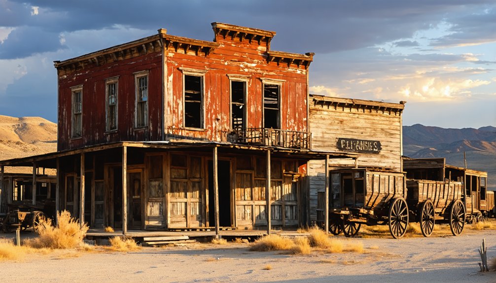
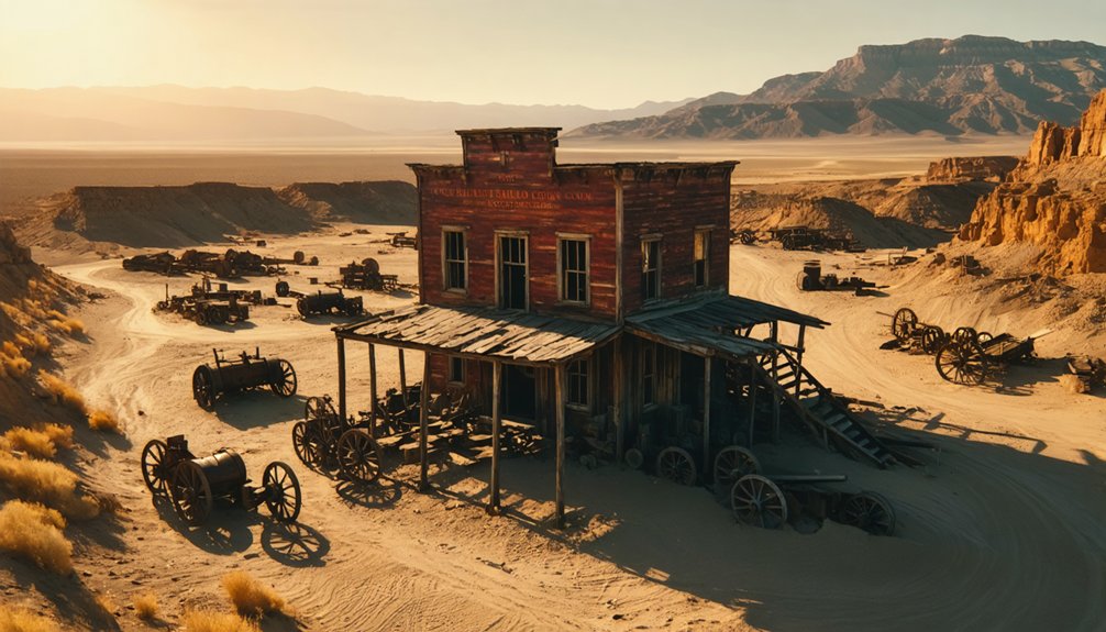
You’ll find exceptional drone photography opportunities at California’s Bodie State Historic Park, featuring well-preserved 1800s architecture and dramatic mountain backdrops. Nevada’s Rhyolite offers stunning desert compositions with its ghostly bank ruins and bottle house. Don’t miss the Salton Sea’s abandoned resort communities, where you can capture haunting aerial perspectives of weathered structures against salt-crusted shores. Your dawn and dusk shoots will benefit from stable desert morning conditions and golden hour lighting. These locations hold countless creative angles waiting to be discovered.
Key Takeaways
- Bodie State Historic Park in California offers exceptional ghost town photography with well-preserved structures and dramatic Sierra Nevada backdrops.
- Rhyolite Ghost Town near Death Valley provides stunning desert landscapes and historic ruins perfect for golden hour aerial shots.
- The Salton Sea Beach ghost town features unique decay aesthetics and striking geometric patterns ideal for midday drone photography.
- Cerro Gordo Ghost Town in California’s Inyo Mountains presents dramatic elevation changes and historic mining structures for varied compositions.
- Old Garnet Ghost Town in Montana offers dense forest surroundings and historic buildings with minimal tourist traffic for peaceful shoots.
Essential Gear for Ghost Town Aerial Photography
When planning aerial photography missions to ghost towns, assembling the right gear guarantees successful shoots in these remote locations. Your drone gear must include high-capacity batteries with charging hubs for extended flight times up to 43 minutes, especially vital in isolated areas. Consider adding a Two-Way Charging Hub to simultaneously power multiple batteries between shoots. Investing in a full-frame camera offers superior low-light performance when shooting dimly lit ghost town interiors from above.
Quality ND and polarizing filters are photography essentials that’ll optimize exposure and reduce glare when capturing weathered structures. You’ll need a three-axis gimbal system to guarantee steady footage in unpredictable ghost town winds, while propeller guards protect your drone during close-range structural shots.
Don’t forget high-speed microSD cards for continuous shooting, and pack spare propellers for quick repairs. A protective carrying case and portable landing pad will safeguard your equipment when maneuvering through rough terrain between abandoned buildings.
Understanding Local Drone Regulations and Permits
Before launching your drone at any ghost town location, you’ll need to navigate a complex web of federal, state, and local regulations that govern unmanned aircraft operations.
Start by ensuring your drone’s FAA registration is current and clearly displayed if it weighs over 0.55 pounds.
Check B4UFLY or FAA UAS Data Delivery systems for airspace restrictions, TFRs, and nearby airports before each flight.
You’ll need to secure property access permissions and special permits – especially on federal lands, state parks, or protected historic sites. Many agencies require applications 30-60 days in advance.
For controlled airspace operations, obtain LAANC authorization or file necessary waivers.
Remember to maintain visual line of sight and stay under 400 feet AGL unless specifically authorized. First Person View operations require a visual observer present at all times.
Both recreational and commercial drone pilots must carry proof of having passed their TRUST or Part 107 certification during all flights.
Night operations demand anti-collision lighting and compliance with visibility standards.
Best Times of Day for Ghost Town Drone Shots
Your most impactful ghost town drone shots will come during the golden hours, when the sun’s low angle creates dramatic shadows and bathes deteriorating structures in warm light 20-60 minutes after sunrise or before sunset.
While midday photography typically produces harsh contrasts, you can strategically use intense overhead shadows to frame architectural details and create striking geometric patterns in your aerial compositions. Professional apps like Sun Surveyor can help you plan the perfect golden hour timing for your ghost town shoot. Similar to capturing the tranquil reflections at Mono Lake, early morning shoots offer peaceful, uncrowded conditions for drone photography.
For ethereal pre-dawn atmosphere, position your drone during blue hour, when early morning fog and mist often enhance the abandoned town’s mysterious qualities while providing stable flying conditions.
Golden Hour Magic
To capture ghost towns in their most dramatic light, the golden hour presents unmatched opportunities for drone photographers, offering warm directional illumination that accentuates weathered textures and creates compelling shadows.
You’ll find longer shooting windows during summer months, especially at higher latitudes, with light dynamics that transform abandoned structures into striking subjects. Experts recommend arriving 30 minutes early to prepare your equipment before the golden light begins.
Set your drone’s camera to RAW and start with low ISO settings (100-200), adjusting gradually as light fades. The soft, warm light creates an enchanting atmosphere that bathes the ghost town ruins in rich golden tones. Use Manual or Aperture Priority modes to maintain control during rapid light shifts.
For ideal results, position your drone to leverage side-lighting, which reveals intricate details in weathered wood and corrugated metal.
Scout locations in advance using sun-tracking apps like PhotoPills to pinpoint precise golden hour timing, and arrive early to maximize your shooting window during these fleeting moments of perfect light.
Midday Shadow Play
While many photographers avoid midday shoots, ghost town drone photography can leverage harsh overhead sunlight to create compelling geometric compositions through shadow play.
Position your drone between 10:30-14:30 to capture high-contrast shadows from broken siding, debris, and skeletal structures. These elements create striking negative-space patterns that add depth to your compositions. The vivid colors pop naturally during these hours, making rusty metals and weathered surfaces more visually striking. Consider using a polarizing filter to reduce atmospheric haze and enhance color saturation in your aerial shots.
To handle extreme midday light, employ exposure bracketing (±1-3 EV steps) or use your drone’s HDR mode. Meter off weathered wood or rust rather than bright skies, and monitor your histogram to prevent highlight clipping.
For dramatic narrative impact, frame your shots to include both sunlit surfaces and shadow pockets. You’ll want to time your flights strategically – capture elongated shadows across courtyards and streets to convey scale while exploiting side-lighting on windows and doorways for textural contrast.
Pre-Dawn Blue Light
Moving beyond harsh midday contrasts, pre-dawn blue hour offers ghost town photographers an otherworldly palette between civil and nautical twilight.
You’ll find peak atmospheric effects about 10 minutes before sunrise, when the sun sits 4-6 degrees below the horizon, bathing abandoned structures in ethereal 12000K violet-blue light.
To capture pre-dawn serenity, position your drone at elevated angles 15-30 minutes before sunrise.
The still conditions and dim sky create perfect balance between weathered buildings and the inky blue canvas above.
Mount your drone with a low ISO setting and slower shutter speeds to emphasize soft moving elements like morning mist.
Track timing precisely using astronomy apps – you’ve got a narrow 20-40 minute window before golden hour takes over, transforming the ghost town’s mysterious blue atmosphere into warmth.
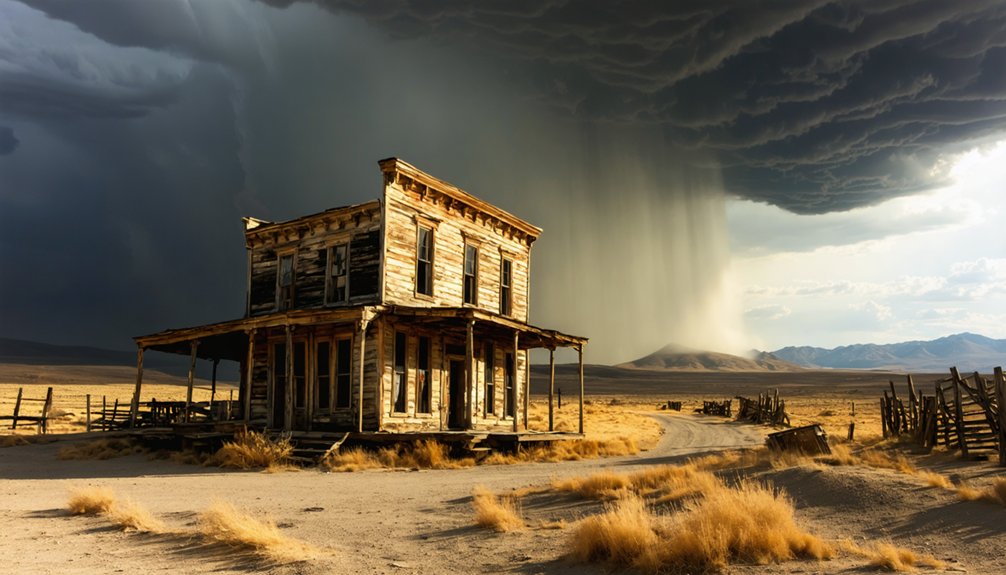
Desert ghost towns present unique meteorological challenges that demand careful consideration before launching your drone.
You’ll need to carefully monitor both seasonal patterns and daily weather fluctuations that can impact your flight performance. During summer months, temperatures exceeding 110°F can degrade battery life and overheat sensors, while winter nights below freezing reduce battery capacity by up to 30%.
Watch for monsoon season’s sudden storms and gusty outflow winds that can force emergency landings.
Spring brings particularly challenging conditions with strong crosswinds through passes and valleys, while thermal updrafts over sun-baked terrain can destabilize your drone during precise structural shots.
Consider scheduling flights during calmer morning hours and always carry backup batteries to compensate for weather-related performance drops.
Creative Angles for Capturing Historic Structures
When shooting historic ghost town structures from above, you’ll want to position your drone to capitalize on natural leading lines created by old wagon trails, fence posts, and railroad tracks that draw viewers toward the main architectural elements.
You can maximize dramatic shadows and textures by launching at sunrise, when the low-angle light rakes across weathered wood and rusted metal surfaces, creating compelling contrasts that highlight structural decay.
For the most striking compositions, fly systematic grid patterns at varying altitudes to reveal repetitive architectural elements like roof patterns, chimney placements, and window alignments that might go unnoticed from ground level.
Leading Lines From Above
Though mastering aerial composition takes practice, drone photographers can harness the power of leading lines to create compelling ghost town imagery from above.
Your drone’s position relative to structural elements can transform ordinary scenes into dramatic linear perspectives that guide viewers through the frame. By positioning your aircraft at specific heights and angles, you’ll reveal powerful aerial composition opportunities unique to ghost towns.
- Position at 30-80ft with a 20-45° tilt to emphasize horizontal boardwalks while maintaining architectural detail
- Offset your drone 10-30° laterally to convert parallel rooflines into converging vectors
- Align at 60-90° tilt between 120-400ft to straighten winding paths into strong linear elements
- Use slow forward flight with subtle altitude changes to create dynamic parallax between foreground and background lines
Light and Shadow Play
Mastering light and shadow interplay can transform your ghost town drone photography from simple documentation into compelling artistic compositions.
You’ll find exceptional shadow contrast at Salton Sea Beach, where collapsed structures create dramatic patterns during midday flights.
Exploit the light dynamics at Bodie’s preserved buildings during golden hour, when elongated shadows merge with the Eastern Sierra backdrop.
For maximum impact, position your drone at Cerro Gordo during early morning, capturing the stark shadows cast by silver mine remnants across the Owens Valley.
Rhyolite’s concrete blocks offer clean-edged shadows at sunrise, while Mojave’s abandoned vehicles create intricate silhouettes at twilight.
Launch your drone at varying altitudes to experiment with shadow angles, and time your shoots to leverage the harsh desert light’s natural drama against weathered surfaces.
Structural Patterns at Dawn
To capture structural patterns at dawn, position your drone strategically above ghost towns where historic architecture creates compelling geometric compositions against the emerging light.
Bodie’s weathered buildings and Rhyolite’s modernist forms offer perfect opportunities for aerial symmetry, while Cerro Gordo’s mine structures create radial patterns in the early morning glow.
- Utilize DJI’s hyperlapse mode to track structural decay across Salton Sea Beach’s fragmented walls and rooflines
- Frame Goldfield’s vertical shafts against horizontal rail lines for grid-like patterns
- Exploit Bodie’s repetitive rooftops by positioning your drone at 45-degree angles during golden hour
- Capture Rhyolite’s orthogonal lines by maintaining consistent altitude while varying your drone’s gimbal angle
Light and Shadow Techniques for Dramatic Footage
When capturing ghost towns with your drone, manipulating light and shadow can transform ordinary ruins into compelling visual narratives.
To master shadow dynamics, launch your flights during golden hour, positioning your drone when the sun sits 10-25° above the horizon. This creates dramatic elongated shadows that reveal structural textures and architectural details.
For maximum impact, fly at 10-60m altitude while using spot metering to balance exposure between sunlit facades and shadow areas.
Create stark silhouettes by positioning your drone with the sun at the frame’s edge, using higher f-stops to sharpen edges.
For enhanced light manipulation, utilize oblique angles between 45-70° to capture cross-lighting effects that highlight surface textures.
Remember to bracket your exposures when shooting high-contrast scenes to preserve both highlight and shadow detail.
Planning Your Ghost Town Photography Route
Successful ghost town drone photography hinges on strategic route planning across the American West’s most photogenic ruins. Your itinerary optimization should leverage key driving routes like Nevada State Route 374, connecting prime locations while maximizing shooting windows during golden hours.
Focus on clustering accessible sites – Bodie and Rhyolite form a natural loop from Reno, while Silver City offers expansion options.
- Map your multi-day circuit with Beatty, NV as your refuel hub for Rhyolite access.
- Schedule dawn shoots at Bodie (6-8 AM) before heading south to Rhyolite for dusk.
- Allow flexibility for weather windows, prioritizing clear, low-wind conditions.
- Structure your route to hit sites during spring-fall, avoiding winter access issues.
Pack your DJI Mavic Air 3 and extra batteries – you’ll need the endurance for this 500-mile adventure.
Safety Tips for Remote Location Drone Flying
Flying drones in remote ghost towns requires rigorous adherence to FAA regulations while managing unique environmental challenges.
You’ll need to stay below 400 feet AGL and maintain visual line of sight while maneuvering deteriorating structures and unstable terrain. Before launching, conduct thorough pre-flight checks of your drone’s systems and calibrate your compass away from magnetic interference from old mining equipment.
Always stay under 400 feet and perform pre-flight system checks when flying drones near abandoned mines and crumbling structures.
Plan for limited internet connectivity by downloading offline maps and storing flight data locally on SD cards. Keep backup batteries protected from dust and extreme temperatures common in ghost town environments.
Set clear boundaries using physical landmarks rather than relying solely on geofencing. When flying near historic structures, maintain at least 50 feet of clearance and watch for hidden obstacles like partially collapsed roofs or rusty power lines.
Post-Processing Techniques for Ghost Town Imagery
Post-processing brings ghost town drone imagery to life through targeted adjustments that preserve authenticity while maximizing visual impact.
When editing your aerial shots, focus on color corrections that separate shadows from highlights while maintaining natural saturation levels. Exposure blending techniques using HDR software help you capture complete tonal ranges in challenging lighting conditions.
- Apply lens correction profiles to eliminate barrel distortion and perspective issues common in drone photography.
- Use Lightroom’s white balance tools to neutralize color casts from varying flight times.
- Blend multiple exposures in Photoshop using manual masks for realistic shadow and highlight detail.
- Create mood through selective dodging and burning while adding subtle vignettes to direct viewer focus.
Fine-tune your workflow with preset combinations that enhance dramatic color without compromising the raw authenticity of these historic locations.
Preserving History Through Aerial Documentation
Modern aerial documentation through drone photography serves as an essential tool for preserving ghost town history at unprecedented levels of detail.
You’ll maximize historical documentation by capturing high-resolution orthomosaic maps that reveal settlement layouts, structural conditions, and landscape contexts previously hidden from ground-level observation.
To guarantee proper aerial preservation, you’ll need to comply with airspace regulations and obtain necessary permits, especially for protected sites.
Deploy ground control points for centimeter-accurate positioning, and maintain 80% forward and 70% side overlap during flights.
Your drone’s RGB sensors will document current conditions, while multispectral or thermal imaging can reveal subsurface features.
Remember to respect privacy boundaries and cultural sensitivities when flying near occupied areas or Indigenous sites.
Store your captured data securely and establish clear sharing protocols to protect these irreplaceable historical records.
Frequently Asked Questions
Which Ghost Towns Allow Camping Nearby for Extended Drone Photography Sessions?
You’ll find prime camping near Rhyolite, Cerro Gordo, and Bodie, but check camping regulations first. BLM lands offer 14-day stays, while photography permits are required for commercial drone operations.
Are There Guided Drone Photography Tours Available at Any Ghost Towns?
You’ll find guided tours combining drone and ground photography at select ghost towns, but they’re typically part of broader workshops where operators handle photography regulations and necessary permits.
How Do Seasonal Changes Affect Accessibility to Different Ghost Town Locations?
You’ll face weather conditions ranging from summer heat to winter snow that limit access. Plan your drone flights around seasonal landscapes, road closures, and administrative restrictions that vary by location.
Which Ghost Towns Require Advance Permission From Historical Societies for Drone Flights?
You’ll need advance clearance at all listed sites: Cerro Gordo from owners, Bodie from State Parks, Goldfield from operators, and Grafton from Heritage Partnership – historical preservation regulations govern drone flights.
You shouldn’t fly drones through collapsed structures due to severe safety risks. Unstable load-bearing elements, hidden voids, and compromised structural integrity make indoor navigation extremely dangerous for both equipment and preservation.
References
- https://www.youtube.com/watch?v=SXW3te7OTC8
- https://99wfmk.com/drone-photos-of-fayette/
- https://www.nationalparksatnight.com/blog/2021/10/23/from-shadows-of-the-past-5-photos-of-ghost-towns-at-night
- https://www.youtube.com/watch?v=-er4dnYAXo8
- https://www.youtube.com/watch?v=FEiWdlOSoiw
- https://www.youtube.com/watch?v=wVfnW55tHO0
- https://www.samys.com/c/Drone-Accessories/3/380.html
- https://dronevideos.com/real-estate-photography-equipment/
- https://dronelaunchacademy.com/resources/real-estate-photography-equipment-guide/
- https://dronesdeli.com/blogs/blog-posts/the-best-drone-accessories-for-professional-photographers


