You’ll find exceptional drone photography opportunities at Arizona’s top ghost towns: Castle Dome offers stunning geometric compositions with preserved mining structures, while Vulture City provides overhead mosaic possibilities of restored buildings. Gold King Mine delivers vertical drama with steep hillside terrain, and Ruby’s remote location guarantees crowd-free shooting. Don’t miss Sundad’s mysterious rock art symbols across the desert landscape. Each site requires specific gear setups and knowledge of FAA regulations to capture their unique stories effectively.
Key Takeaways
- Castle Dome offers exceptional aerial geometry with preserved mining structures and dramatic shadows, best photographed during winter’s low sunlight angles.
- Vulture City provides restored boomtown buildings perfect for overhead mosaics and comprehensive layout documentation with minimal tourist interference.
- Gold King Mine features dramatic vertical terrain and weathered structures, ideal for dynamic reveal shots from canyon floor to ridgetop.
- Ruby’s remote location ensures crowd-free shooting opportunities while offering untouched landscapes and historically significant structures.
- Sundad presents unique opportunities to capture ancient rock art symbols against desert landscapes, creating compelling aerial compositions with cultural significance.
Must-Visit Ghost Towns for Aerial Photography
Drone photographers seeking unique aerial perspectives will find Arizona’s historic ghost towns to be treasure troves of visual opportunities.
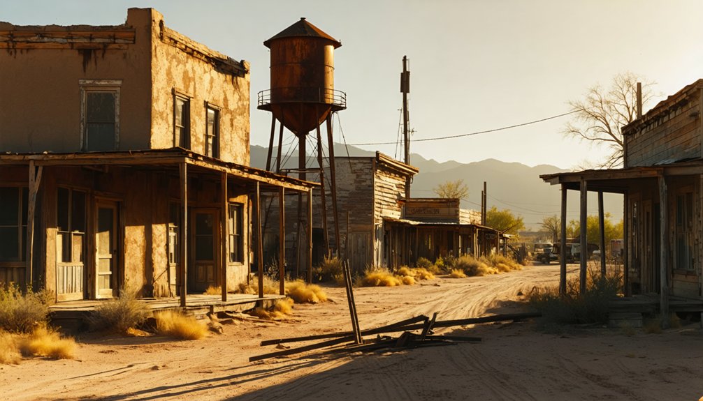
Castle Dome delivers stunning aerial geometry with its preserved mining structures and adobe buildings, especially during winter’s low-angle light. You’ll capture dramatic shadows from mine timbers and building rows against the desert backdrop. The site’s smooth dirt road makes equipment transport hassle-free.
Winter sun paints stark shadows across Castle Dome’s adobe ruins, creating a geometric masterpiece perfect for aerial photography.
At Vulture City, you can document the restored boomtown’s footprint through overhead mosaics, featuring vintage buildings and equipment.
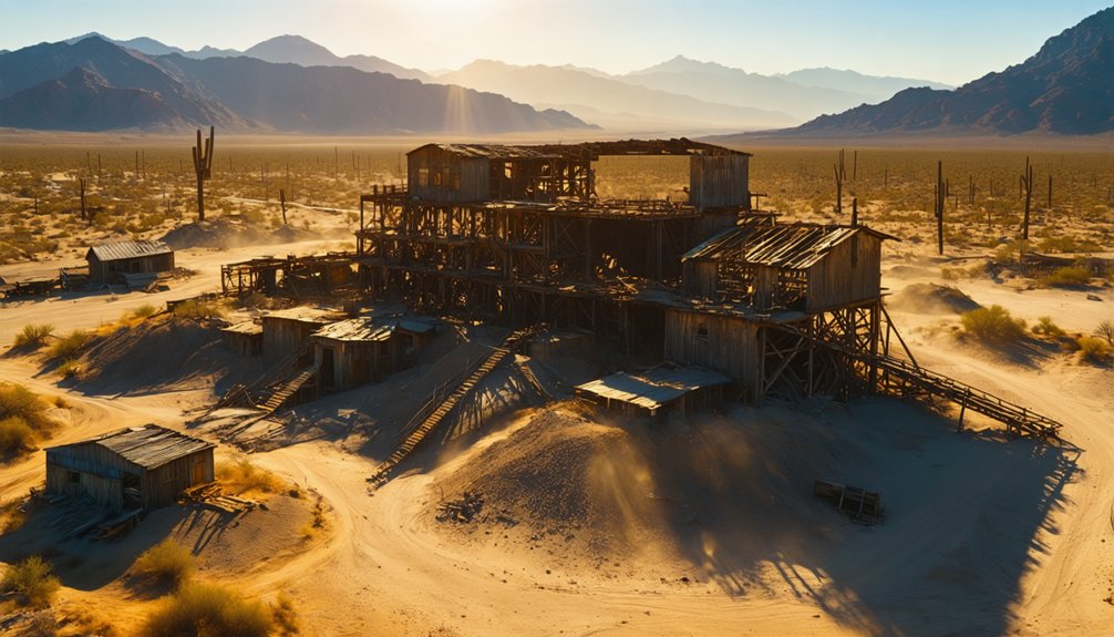
The Gold King Mine near Jerome offers vertical drama – exploit the steep hillside terrain for reveal shots from canyon floor to ridgetop.
When conditions permit, venture to remote Ruby for crowd-free shooting.
Sundad provides compelling compositions with its mysterious rock art symbols scattered throughout the desert landscape.
Plan your flights around posted boundaries, respect no-fly zones, and consider seasonal timing for ideal visibility and minimal tourist interference.
Essential Gear and Equipment Setup
When photographing ghost towns from above, you’ll need a drone that combines reliable flight time of 20-30 minutes per battery with a high-quality sensor of at least 1-1.5″ CMOS for ideal low-light performance.
Your platform should feature a 3-axis mechanical gimbal stabilization system and thorough obstacle avoidance capabilities to safely navigate around historical structures while maintaining smooth footage. The DJI Mavic 3 CINE excels at capturing intricate landscape details in wide cinematic shots of these historic locations. Consider investing in a Hoodman Aviator Hood to minimize screen glare and maintain optimal visibility of your flight display in bright desert conditions.
Pack essential field gear including 3-5 batteries per pilot, ND filter sets, high-speed storage media, and a portable charging solution with both vehicle power and backup battery options.
Optimal Drone Selection Guide
Selecting ideal aerial photography equipment requires careful consideration of three distinct drone categories: budget-conscious options under $1000, mid-range systems between $1000-$2000, and premium platforms exceeding $2000.
For ghost town exploration, you’ll want to prioritize drones with robust flight performance and superior image quality. The DJI Mini 5 Pro offers exceptional value with its sub-250g weight and 4K capabilities, perfect for capturing narrow pathways between abandoned structures. The drone’s 90-degree rotating camera allows for unique vertical shots of building facades. The Potensic ATOM 2 provides 32-minute flight time for extended shooting sessions.
For more demanding shoots, consider the DJI Air 3S with its dual-camera system and extended 45-minute flight time. If budget allows, the Mavic 4 Pro’s Micro Four Thirds sensor delivers unmatched dynamic range for dramatic sunset shots over weathered buildings.
Choose systems featuring autonomous flight modes and 360° obstacle avoidance to safely navigate deteriorating structures.
Field Packing Essentials
Having chosen your aerial platform, proper field equipment preparation stands between success and failure at ghost town locations.
You’ll need a thorough battery management strategy with multiple flight packs, a high-capacity power station, and a multi-bay charging system to maintain continuous operations. Bring at least five flight batteries to ensure extended shoot times in remote locations. Keep your cells at ideal temperature using insulated pouches for cold mornings and ventilated cases for afternoon heat.
Your transport solutions must include a custom-fitted hard case with foam compartments, plus weatherproof dry bags to protect against Arizona’s harsh elements. Consider bringing a large trash bag for additional weather protection during sudden storms.
Pack modular organizers for props, tools, and filters, alongside a portable landing pad for dusty conditions.
Don’t forget your Part 107 documentation, high-visibility markers, and emergency gear. A first-aid kit, PPE, and clear communication plan round out your essential field kit.
Before launching your drone at any ghost town location, you’ll need to navigate a complex web of federal, state, and local flight restrictions.
Visual line of sight must be maintained with your drone at all times while operating near ghost town structures.
If your drone weighs over 0.55 pounds, you must register with the FAA and comply with Remote ID requirements. You’ll also need to pass the TRUST test for recreational flights or obtain a Part 107 certificate for commercial photography.
Check your planned ghost town’s airspace classification and obtain ATC authorization if it’s in controlled airspace. Non-compliance with registration requirements can result in steep financial penalties of up to $27,500.
Many historic sites fall under municipal park jurisdiction or private property management, requiring specific permits or landowner permission.
Stay below 400 feet AGL and maintain awareness of nearby critical facilities, which mandate 500-foot horizontal and 250-foot vertical buffers.
Remember that National Park Service properties completely prohibit recreational drone flights unless explicitly authorized.
Best Times and Seasons to Shoot
When planning your ghost town drone shoots, ideal timing centers on the golden and blue hours that bookend each day. You’ll find prime conditions 30-90 minutes after sunrise or before sunset, when low-angle light creates dramatic textures and shadows across weathered structures.
Seasonal considerations dramatically affect your shooting windows, with winter offering desaturated tones and longer shadows, while autumn delivers rich colors and stable conditions.
Each season paints ghost towns differently – winter washes out colors and stretches shadows, while fall brings vibrant hues and steady skies.
- Morning flights (first 2 hours post-sunrise) provide calmest winds and coolest temps for maximum battery efficiency
- Evening blue hour (20-40 minutes post-sunset) enables balanced exposure for light-painting techniques
- Monsoon season (July-September) offers dramatic skies but requires vigilant weather monitoring
- Spring blooms create compelling color contrasts against ruins when winter rains cooperate
Consider weather patterns carefully, particularly wind forecasts and gusts that could compromise your drone’s stability and image quality.
Advanced Photography Techniques
You’ll master ghosting effects by setting your drone camera to long exposures of 2-4 seconds while executing precise lateral movements at twilight.
When shooting vertically, position your drone directly above abandoned structures to create symmetrical compositions that emphasize geometric patterns and textures of weathered rooftops.
For maximum impact, combine both techniques by capturing vertical long exposures during blue hour, allowing you to record light trails from passing clouds while maintaining sharp detail in the ghost town’s architectural elements below.
Long Exposure Ghost Effects
Creating ethereal ghost effects in drone photography requires mastering long exposure techniques with precise timing and camera settings. You’ll need a minimum 15-second exposure to achieve ghostly transparency, with best results coming from 20-30 second exposures.
Set your drone’s camera to shutter priority mode and use the lowest possible ISO to minimize noise while maintaining an aperture between f/2.8 and f/11.
- Mount your drone on a stable platform and use manual focus after initial autofocus
- Keep your subject stationary for 10-20 seconds, then direct rapid movement
- Shoot during dusk or low light conditions for ideal exposure times
- Consider using ND filters when ambient light prevents desired shutter speeds
Advanced photographers can experiment with multiple subjects, light trails, or self-ghosting techniques by entering the frame late in the exposure.
Vertical Composition Mastery
Mastering vertical composition techniques elevates your drone photography by transforming ghost town scenes into dramatic, height-focused narratives. You’ll want to position your drone to capture the commanding vertical lines of weathered mine shafts, towering headframes, and crumbling church steeples against Arizona’s vast sky.
Deploy a three-layer approach by dividing your frame into distinct zones: position decaying structures in the foreground, connect them to midground elements like abandoned streets, and use distant mountains as your background.
When flying through narrow ghost town corridors, switch to portrait orientation to emphasize the claustrophobic atmosphere of these forgotten spaces. For maximum impact, fly low and close to architectural features, then angle your camera upward to create powerful leading lines.
Remember to maintain adequate spacing between elements to prevent visual clutter in your vertical compositions.
Capturing the Perfect Aerial Shot
To achieve stunning aerial shots of ghost towns, timing your drone flight during the golden hours proves essential. The low-angle sunlight creates dramatic shadow play across abandoned structures, enhancing your aerial composition with natural contrast. You’ll want to position your drone strategically to capture those long shadows stretching across the desert floor.
- Deploy wide-angle settings to showcase the vast expanse of desolation while maintaining structural details.
- Execute long exposures during stable atmospheric conditions to record cloud movements.
- Map out key features beforehand using satellite imagery for efficient flight paths.
- Position your drone to capture silhouettes against the warm sunset light.
When conditions align perfectly, you’ll capture the ethereal beauty of these forgotten places from perspectives that ground-based photographers can’t access.
Remember to maintain line-of-sight and monitor your battery levels while chasing that perfect shot.
Safety Guidelines and Site Etiquette
While exploring ghost towns with your drone presents unique photographic opportunities, strict adherence to FAA regulations and local ordinances remains paramount.
You’ll need to complete your TRUST test, register drones over 0.55 lbs, and maintain visual line of sight below 400 feet AGL. Keep your B4UFLY app handy to check airspace restrictions.
For ideal drone safety, launch from designated areas and stay clear of critical facilities.
Pack high-clearance transportation and plenty of water when accessing remote sites. Proper site etiquette demands maintaining respectful distances from wildlife and avoiding flights over populated areas.
Remember to check private property boundaries and stay 500 feet from structures without consent.
When photographing, respect privacy laws and keep your distance from any remaining inhabitants or visitors.
Post-Processing Tips for Ghost Town Footage
Professional post-processing transforms raw ghost town drone footage into compelling visual narratives that capture the haunting essence of abandoned places.
When processing your aerial captures, you’ll want to leverage HDR blending techniques to balance the harsh desert lighting while preserving both shadow and highlight details. Start by merging bracketed exposures, then apply selective sharpening to emphasize weathered textures without introducing unwanted artifacts.
- Capture in RAW format with 80% overlap for maximum editing flexibility and panorama stitching options
- Use exposure fusion workflows to reveal intricate details in both sun-bleached structures and deep shadows
- Apply localized noise reduction to maintain crisp edges while cleaning up high-ISO shots
- Create atmospheric depth through selective color grading and subtle dehaze adjustments to enhance the sense of abandonment
Frequently Asked Questions
How Do Wild Animals and Burros React to Drones in Ghost Towns?
You’ll observe strong startle responses and flight behavior when your drone approaches wildlife – animals typically display elevated stress, vigilance, and quick retreat, while burros show unpredictable reactions risking collisions.
What’s the Average Battery Life for Drones in Arizona’s Desert Conditions?
You’ll get 15-20 minutes per battery in Arizona’s 100°F+ summer heat versus normal 30-minute capacity. Proper drone maintenance and battery management requires rotating 4+ batteries for sustained desert operations.
Are There Guided Drone Photography Tours Available at These Locations?
You’ll find limited dedicated guided drone tours, but you can hire local drone guides or join meetup groups. Most ghost towns require special permits and follow strict drone regulations.
Which Ghost Towns Allow Night or Low-Light Drone Photography?
Like a desert owl seeking prey, you’ll find no ghost towns explicitly permitting nighttime drone flights. Follow FAA’s visibility rules and remote sites’ standard regulations for low-light techniques away from restricted areas.
Exploring stargazing locations in Arizona offers a breathtaking canvas of celestial wonders. The dark skies above the Sonoran Desert create an unparalleled backdrop for astronomers and casual observers alike. Be sure to bring a telescope or binoculars to enhance your experience under the vast expanse of twinkling stars.
Can I Sell My Ghost Town Drone Footage Commercially?
You’ll need Part 107 certification, property releases, and verified land permissions to sell footage commercially. Check drone regulations, copyright issues, and platform requirements before monetizing your ghost town content.
References
- https://pamphotography.blog/2023/05/22/photographing-four-ghost-towns-in-arizona/
- https://www.youtube.com/watch?v=eKMSVZZ2ZQ0
- https://www.youtube.com/watch?v=TwtfLGGhUsA&vl=en
- https://www.youtube.com/watch?v=-er4dnYAXo8
- https://www.tripadvisor.com/Attractions-g28924-Activities-c47-t14-Arizona.html
- https://www.youtube.com/watch?v=N_YydcABPJg
- https://joinotto.com/photographers/best-drone-photography-arizona
- https://www.fox10phoenix.com/video/1732870
- https://www.youtube.com/watch?v=c4Nj3D08Jvk
- https://www.seneca-photography.com/blog/gear-list


