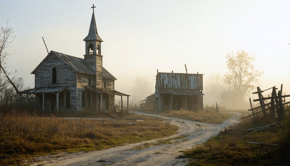
You’ll find spectacular drone photography opportunities at three haunting Illinois locations: Parker City’s geometric grid of concrete foundations, Cairo’s deteriorating iron-fronted buildings at the river confluence, and Mounds’ dramatic brick ruins on East Main Street. Capture your best aerial shots during winter’s low sun angles or fall’s vibrant colors, using a sub-250g drone equipped with ND filters. Launch from established parking areas, and you’ll discover why these ghostly remnants tell compelling stories from above.
Key Takeaways
- Parker City offers extensive concrete foundation grids and historic rail lines, best captured during winter months for enhanced visibility.
- Cairo’s abandoned downtown district features photogenic iron-fronted buildings and the deteriorating Gem Theater along Route 51.
- Mounds provides dramatic brick ruins on East Main Street, with optimal drone shots during sunrise and sunset.
- All three locations offer ideal shooting conditions in spring and fall mornings when wind speeds are below 10mph.
- Winter photography provides the best structural contrast with low sun angles, while autumn offers vibrant foliage backgrounds.
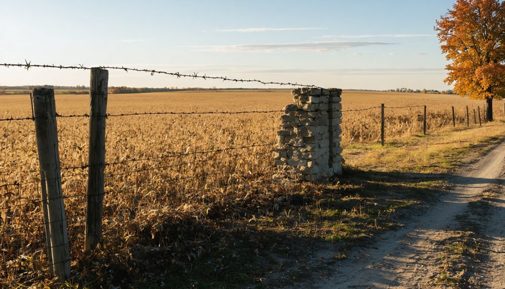
Exploring Parker City’s Hidden Foundations
A ghostly grid of concrete foundations stretches beneath your drone’s camera at Parker City, where two historic rail lines once intersected in southern Illinois.
You’ll spot hidden architecture through your viewfinder – scattered concrete blocks and stair remnants that once supported two hotels, stores, and barbershops in this 200-resident railroad hub.
Launch from designated Tunnel Hill State Trail parking areas for the best aerial views of ghostly remnants.
Access remnants of Parker City’s past with aerial shots launched from Tunnel Hill State Trail’s convenient parking zones.
Your drone can capture compelling compositions where metal posts and former utility poles pierce through vegetation-covered lots.
Winter flights offer ideal visibility of foundation outlines, while fall colors create stunning contrasts between nature’s reclamation and man-made elements.
Today, this ghost town is just one of five abandoned communities that dot the 45-mile trail’s historic path.
Follow the old rail corridors to discover perfect leading lines for dramatic aerial shots of this forgotten crossroads.
The Illinois Central Railroad trains required mandatory stops here, making this location a crucial transportation checkpoint in its heyday.
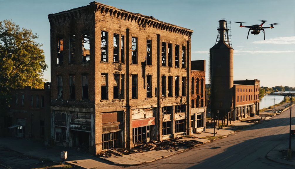
Aerial Views of Cairo’s Urban Decay
Perched at the dramatic confluence of America’s two mightiest rivers, Cairo offers drone photographers an unforgettable study in urban abandonment.
You’ll find prime shooting conditions along Route 51, where your drone can capture the stark contrast between nature’s reclamation and Cairo’s history of industrial prominence.
Launch your aerial gear over the northwest sector to document the haunting remains of once-grand residences, now surrendering to overgrowth.
For urban exploration highlights, target the downtown district’s iron-fronted buildings and the iconic Gem Theater‘s skeletal marquee.
The town’s strategic location at the Mississippi-Ohio junction provides stunning contextual shots that tell the story of this former 15,000-strong community, now home to barely 2,000 souls.
Work quickly – systematic demolition means these ghostly urban landscapes won’t last forever.
Fine art photographers like Keith Dotson have made multiple visits to document the city’s black and white photography potential.
The city’s decline accelerated after the turbulent 1960s when racial tensions erupted and drove many residents away.
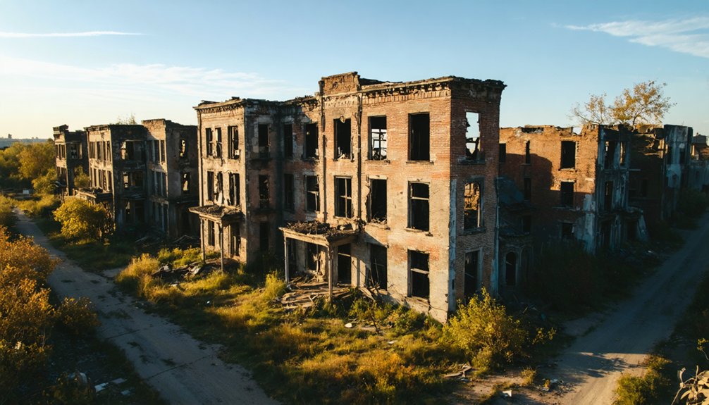
Capturing Mounds’ Brick Ruins From Above
While many ghost towns offer aerial opportunities, Mounds’ crown jewel lies in its dramatic brick ruin on East Main Street.
The site’s historical significance dates back to the Mississippian period, when Native Americans created monumental earthworks in the region.
You’ll discover striking aerial perspectives as your drone captures the exposed masonry shell against the backdrop of the historic Mounds High School. The brick texture and collapsed interior create compelling patterns, especially when framed from 30-120 meters up. Celebrated photographer Keith Dotson has extensively documented these haunting structures in his fine art work.
For the best shots of these architectural remains:
- Time your flight for sunrise or sunset when shadows emphasize the mortar joints and brick relief.
- Use faster shutter speeds (1/500s+) at low altitudes to combat rotor vibration.
- Shoot RAW at 20-35mm equivalent for context, switching to 50-70mm for detailed façade work.
Remember to secure proper permissions and maintain visual line-of-sight while exploring this haunting reminder of Mounds’ past.
Safety Guidelines for Ghost Town Drone Photography
Before launching your drone at any ghost town site, you’ll need to verify flight zone restrictions and obtain necessary permissions from property owners or local authorities.
Consult Airmap app to check for any restricted airspace or temporary flight restrictions in the area.
You should thoroughly inspect your equipment, including checking battery levels, camera settings, and ensuring your drone’s firmware is up-to-date.
Always bring backup batteries and a spotter to help maintain visual line of sight while maneuvering around historic structures and potential obstacles. Exercise extra caution around unstable structures when flying near deteriorating buildings.
Flight Zone Safety Tips
Before launching your drone, walk the entire site to assess flight risks and establish proper perimeter control. Look out for remnants like old metal posts and deteriorating stairs that could interfere with flight paths. Map out your launch zones and identify any hazards like power lines, unstable structures, or hidden sinkholes that could compromise your flight.
The severe state of urban decay in Cairo requires extra diligence when planning aerial routes around collapsing buildings.
- Set up a clear takeoff/landing area at least 50 feet from deteriorating buildings using high-visibility markers or safety tape.
- Record GPS coordinates of all potential hazards and program your flight path to maintain safe distances.
- Plan multiple emergency landing zones in open areas free from debris, standing water, and overgrown vegetation.
Equipment Check Before Launch
After securing your ghost town flight zone, a thorough equipment inspection stands between you and capturing those perfect aerial shots.
Start with battery maintenance – your drone’s power source must be 100% charged, showing voltage above 3.7V per cell, and keep spare batteries at minimum 80% capacity.
For propeller safety, inspect each blade for cracks or chips, ensuring they’re firmly attached and rotating in the correct direction.
Calibrate your compass away from the ghost town’s metal structures, and verify your GPS shows at least 10 satellites.
Test your camera’s functions and gimbal movements, adjusting settings for low-light conditions typical in abandoned buildings.
Finally, pair your controller, confirm all controls respond smoothly, and verify your return-to-home function is set at the proper altitude.
Best Weather Conditions for Abandoned Site Shoots
While capturing stunning drone footage of ghost towns requires skill and planning, the weather conditions you choose can make or break your shoot. For ideal weather in Illinois, aim to fly during early morning or late afternoon hours when temperatures hover between 50-77°F.
Keep an eye on humidity levels, targeting 30-70% to prevent lens condensation and maintain stable flight patterns.
- Schedule flights during overcast days for even lighting across abandoned structures – perfect for capturing intricate architectural details without harsh shadows.
- Launch your drone when winds stay below 10 mph, especially common during spring and fall mornings in Illinois.
- Monitor approaching weather systems using drone-specific apps, as Illinois’ weather can change rapidly, potentially affecting your equipment’s performance and image quality.
Historical Context Behind These Illinois Ghost Towns
When you’re shooting Illinois ghost towns from above, you’ll find many were once-bustling river ports that lost their economic lifeblood when railroads redirected trade routes in the mid-1800s.
You’ll spot the telltale grid patterns of these abandoned river settlements along the Mississippi and Illinois Rivers, where steamboat-era foundations still peek through overgrown vegetation.
Your aerial footage can capture the mass exodus stories of these communities, as whole populations shifted to nearby railroad towns, leaving behind the skeletal remains of commerce that once thrived on river traffic.
River Trade Decline Impact
Throughout geographic xviii-橡urement blend mid능
Population Migration Stories
As you soar above Illinois’ abandoned settlements, each ghost town reveals compelling migration stories that shaped their rise and fall.
You’ll spot Cairo’s stark population decline, where migration trends transformed a bustling river town of 15,000 into a shell of just 1,700 residents.
Your drone footage will capture Bishop Hill’s Swedish utopian experiment, where immigration waves once brought hopeful settlers seeking communal living.
Over at Shawnee Town, you’ll document how devastating floods forced an entire community’s relocation, while Kaskaskia’s isolation by the shifting Mississippi River drove its population exodus.
These aerial perspectives showcase how natural forces and social upheavals sparked dramatic community impacts, from racial tensions in Cairo to the displacement of river settlements, permanently altering Illinois’ demographic landscape.
Equipment Recommendations for Urban Exploration
Since successful ghost town drone photography hinges on reliable equipment, you’ll need to carefully select your gear for urban exploration missions. For Illinois’ abandoned towns, choose a sub-250g drone with reliable obstacle avoidance and 4K video capabilities to navigate deteriorated structures safely.
Your drone specifications should include a large sensor for low-light performance and automated flight modes for complex maneuvers.
- Pack at least three batteries per flight session, with thermal wraps for Illinois’ unpredictable weather.
- Bring a portable power station for extended shoots in power-less locations.
- Equip ND filters for controlling exposure in bright midwest sunlight.
Smart battery management is essential – monitor health through manufacturer apps and maintain proper storage charge levels between missions.
Your power strategy should account for multiple quick sorties through these historic sites without interruption.
Seasonal Changes and Their Impact on Footage
The changing seasons dramatically reshape your aerial photography opportunities in Illinois’ ghost towns, with each period offering distinct advantages and challenges for drone operators.
As the night sky transforms, the best astrophotography spots in Illinois reveal breathtaking celestial vistas that are often overlooked. From remote parks to serene lakesides, each location provides a unique backdrop for capturing stars and constellations. Exploring these areas not only enhances your skills but also deepens your appreciation for the universe.
Winter’s low sun angle creates striking directional shadows that’ll emphasize deteriorating architecture, while autumn’s vibrant foliage provides natural framing against weathered brick and rusty metal.
You’ll find spring and fall’s overcast conditions perfect for capturing detailed footage textures in crumbling structures, though you’ll need to watch for seasonal lighting shifts that affect white balance.
Plan your flights around weather patterns – winter’s cold limits battery life, but reveals hidden foundations under bare trees.
Summer’s dense vegetation might obscure sites, but extended golden hours let you capture dramatic side-lit facades.
Just remember to adjust your exposure settings as conditions evolve.
Legal Considerations When Flying Over Abandoned Areas

Before launching your drone over Illinois ghost towns, you’ll need to navigate a complex web of state and federal regulations that govern unmanned aircraft operations.
While these abandoned locations might seem perfect for unrestricted flying, you’re still bound by FAA Part 107 requirements and state privacy laws.
Stay compliant by following these essential guidelines:
- Maintain visual line of sight and keep your drone under 400 feet altitude, even when capturing those sweeping shots of deteriorating structures.
- Respect property boundaries – abandoned doesn’t mean unowned, and you’ll need permission if the ghost town sits on private land.
- Don’t record through windows or doorways of remaining structures, as Illinois privacy laws specifically prohibit drone surveillance of building interiors.
Frequently Asked Questions
Are There Any Active Paranormal Investigation Groups Studying These Ghost Towns?
Like shadows at sunset, you’ll find active investigations by Midwestern Paranormal Research Society chapters throughout Illinois ghost towns, while university clubs and independent teams regularly document paranormal phenomena in places like Cairo.
What Happened to the Residents Who Left These Towns?
You’ll find former residents scattered across Illinois’s larger cities and towns, driven by economic decline to seek new jobs, while community displacement forced many into regional hubs where services and opportunities remained intact.
Can Drones Detect Underground Tunnels or Structures in These Locations?
You can’t reliably detect underground tunnels in these ghost towns with standard drone technology. Without specialized ground penetrating radar equipment, your aerial mapping will only reveal surface features and structures.
Are Any Movies or TV Shows Filmed in These Abandoned Towns?
Despite promising panoramas, you won’t find any filmed features here. While these desolate destinations might look perfect for ghost town films or abandoned location series, they’ve remained undiscovered by Hollywood’s cameras.
Exploring ghost towns in Illinois can reveal a rich history of bygone eras. Enthusiasts might find themselves wandering through the remnants of old storefronts and crumbling homes, each telling a story of what once was. These locations offer a unique glimpse into the past, attracting those curious about the lives that filled these now silent streets.
Do Any Former Residents Offer Guided Tours of These Locations?
You won’t find guided explorations by former residents at these ghost towns. While local historians sometimes document these places, they’re primarily explored independently through bushwhacking trails and self-guided drone flights.
References
- https://www.youtube.com/watch?v=lth_H_-_EXk
- https://icatchshadows.com/abandoned-buildings-photography-in-cairo-illinois/
- https://www.youtube.com/watch?v=mB6VhWMp8qw
- https://www.youtube.com/watch?v=bZiAuLtavqw
- https://www.youtube.com/watch?v=ivop7TBcwu8
- https://q985online.com/illinoishikethroughghosttowns/
- https://drloihjournal.blogspot.com/2022/09/lost-towns-of-illinois-parker-city-illinois.html
- https://www.enjoyillinois.com/plan-your-trip/travel-inspiration/a-ride-along-tunnel-hill-state-trail-in-southern-illinois/
- https://www.angelfire.com/in/ParkerCity/history.html
- https://genealogytrails.com/ill/alexander/history_towns.html