You’ll find exceptional drone photography opportunities at Georgia’s atmospheric ghost towns, with Old Car City’s 4,000 classic vehicles creating striking geometric patterns from above. Capture dramatic aerial shots of Scull Shoals Mill Village’s towering brick ruins against the landscape, or frame High Falls’ 135-foot cascade using abandoned grist mill foundations. Visit during golden hour or after rainfall for enhanced textures and moody atmospherics. These haunting locations hold countless secrets waiting to be discovered through your lens.
Key Takeaways
- Old Car City offers 32 acres of classic vehicles creating unique aerial patterns and rust textures perfect for drone photography.
- Scull Shoals Mill Village features towering brick walls and stone foundations that create dramatic compositions from above.
- High Falls combines natural waterfalls with historic mill ruins, providing diverse shooting opportunities for aerial photographers.
- Late autumn and winter seasons provide optimal visibility of abandoned structures through bare trees across Georgia’s ghost towns.
- Golden hour lighting enhances textures and creates long shadows, making it the ideal time for drone photography of abandoned sites.
What Makes Georgia’s Ghost Towns Perfect for Aerial Photography
Five distinct features make Georgia’s ghost towns ideal for drone photography: architectural ruins that pierce the landscape, natural elements that embrace abandoned structures, geometric patterns that create striking compositions, dynamic lighting conditions that transform scenes throughout the day, and layers of history that add depth to every frame.
Georgia’s ghost towns reveal their secrets through the lens of aerial photography, where history and nature dance in haunting harmony.
You’ll discover these elements perfectly aligned at sites like New Manchester Mill, where brick ribs rise against Sweetwater Creek’s flow, creating compelling aesthetics for aerial shots.
At Scull Shoals, moss-softened foundations merge with river fog, while at Banning Mills, stone raceways cut through Snake Creek gorge, capturing narratives of industrial heritage.
The interplay of natural and built environments offers dynamic perspectives, from High Falls’ waterfall-wrapped ruins to Bartow’s tree-embraced structures. The roaring waterfall spray creates dramatic mist effects perfect for atmospheric aerial photography. The painted brick facades of Senoia’s downtown provide striking architectural contrast against the rural landscape. Each location presents unique opportunities for documenting Georgia’s forgotten places from above.
Essential Drone Equipment and Settings for Abandoned Sites
Before you explore Georgia’s decaying structures from above, you’ll need proper safety equipment including an N95 respirator, hard hat, and safety glasses to protect against hazards during drone launch and retrieval.
Aerial photography reveals unique structural patterns and decay that would be impossible to see from ground level.
Using a DJI Mavic Air II provides reliable performance and straightforward deployment for ghost town exploration.
Your camera settings should prioritize RAW capture with exposure bracketing (±1-2 EV) to handle the stark contrast between bright Southern skies and dark building interiors.
You’ll want to maintain a fast enough shutter speed (1/100s+) to prevent motion blur while flying, unless you’re specifically aiming for artistic slow-shutter effects with ND filters and gimbal stabilization.
Safety Gear Checklist
When photographing Georgia’s ghost towns by drone, proper safety equipment becomes your vital defense against the hazards of deteriorating structures and remote locations. Your safety gear checklist must account for both personal protection and emergency procedures in these remote settings.
- Don your PPE basics: sturdy boots with puncture-resistant soles, cut-resistant gloves, high-visibility vest, and safety glasses to protect against hazards common in Georgia’s abandoned mining towns.
- Pack a compact first-aid kit and fire extinguisher rated for LiPo battery fires.
- Secure your drone equipment with propeller guards and a reliable landing pad for Georgia’s uneven terrain.
- Keep emergency communication devices ready – satellite phones are essential as cell coverage is spotty in North Georgia’s abandoned mountain settlements.
Store your batteries in fire-safe bags during transport to prevent potential hazards in the field. Ensure you bring extra batteries and chargers since most commercial drones only last 30-40 minutes per battery in flight.
Camera Settings For Ruins
Now that you’re properly equipped for safety, your drone’s camera settings become your artistic foundation for capturing Georgia’s abandoned settlements.
In these shadowy ruins, you’ll want to master manual mode for complete control over your exposure techniques. Start with the lowest ISO and highest f-stop, then adjust based on available light. Before launching your drone, inform a trusted person about your exploration plans and expected return time. Using a Nikon 20mm lens or similar wide-angle optic will help capture the full scale of these derelict structures.
For low light situations inside crumbling structures, crank your ISO up to 3000+ and shoot in burst mode, capturing at least five frames per scene. You’ll stack these later to reduce noise.
During golden hour, slow down your shutter speed while maintaining a higher ISO to capture the warm light painting across deteriorating walls.
Remember to shoot separate exposures – one for the structure itself and another for the sky – giving you more flexibility in post-processing to reveal the haunting beauty of these forgotten places.
Legal Requirements and Safety Guidelines
Before photographing Georgia’s ghost towns with your drone, you’ll need to complete the TRUST certification and register aircraft over 0.55 lbs with the FAA, displaying the registration number externally.
You must maintain visual line of sight while flying below 400 feet in Class G airspace, though operations at historic sites require special waivers from the Division Director. Federal regulations take precedence when operating drones at ghost town locations.
Remember that state law prohibits launching from private property without owner consent, so secure written permission before setting up your equipment at abandoned locations. The B4UFLY app helps identify restricted airspace and no-fly zones before conducting photography missions at ghost town sites.
Obtaining Required Permits
Operating a drone at Georgia’s ghost towns requires multiple permits and certifications based on your flying purpose and location. Before launching your drone to capture these historic ruins, you’ll need to navigate several permit types and complete specific application processes.
- Register your drone with the FAA through FAADroneZone if it weighs over 0.55 pounds ($5 fee) and display the registration number visibly.
- Complete the FAA’s TRUST certification for recreational flying, which is mandatory for all hobby pilots in Georgia.
- Apply for special permission if your ghost town is within a state park by contacting Division Director Colby Moore with your project details.
- Secure city-specific permits if flying near Augusta or Savannah, including neighbor notifications and additional fees ($150 in Savannah plus $30 application fee).
To successfully capture Georgia’s ghost towns by drone, you’ll need to navigate a complex web of airspace rules that vary based on your location.
Exploring abandoned sites in Georgia can reveal fascinating insights into the state’s history and culture. Many of these locations tell stories of communities that once thrived but have since been forgotten. Capturing their essence from above not only preserves their memory but also sparks interest in their tales.
One of the best ghost towns in Georgia to explore is Ghost Town in the Sky, which offers breathtaking views and remnants of its former life. Visitors are often drawn to the stories behind these locations, as they provide a unique glimpse into the past and the people who once lived there. As you maneuver your drone, you might discover hidden details that paint a more vivid picture of the vibrant histories these ghost towns hold.
Always check if you’re operating in controlled airspace (Class B, C, D, or surface E) near airports, which requires FAA authorization through LAANC or DroneZone. In uncontrolled Class G airspace, you’re limited to 400 feet above ground level.
Remember to broadcast Remote ID signals unless flying in a FRIA, maintain visual line of sight, and stay below 54 km/h.
When photographing abandoned structures, keep clear of any nearby military installations, active railroads, or restricted zones.
Watch for Temporary Flight Restrictions that might affect your flight plans, and always yield to manned aircraft.
Violations can result in federal charges and steep fines.
Old Car City: a Photographer’s Paradise From Above
Nestled in White, Georgia, Old Car City sprawls across 32 acres of forested land where over 4,000 classic vehicles create a mesmerizing canvas for drone photographers.
Along 6+ miles of winding trails, you’ll find endless opportunities to capture stunning aerial compositions where nature reclaims vintage metal.
Where metal meets wilderness, winding pathways unveil the perfect stage for dramatic aerial imagery of nature’s slow triumph.
When planning your drone shots, consider these composition strategies:
- Capture top-down patterns of clustered car roofs and rust textures
- Execute low oblique sweeps along rows to emphasize depth and leading lines
- Frame elevated panoramas showcasing the site’s vast forest context
- Focus on detail-driven passes highlighting unique vehicle arrangements
Remember to secure advance permission for drone operations and follow FAA regulations.
With high visitor traffic on the trails, maintain safe altitudes and respect privacy zones while documenting this extraordinary automotive graveyard.
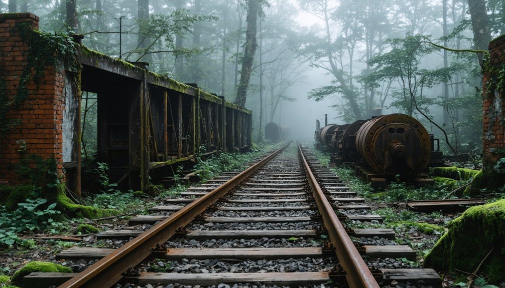
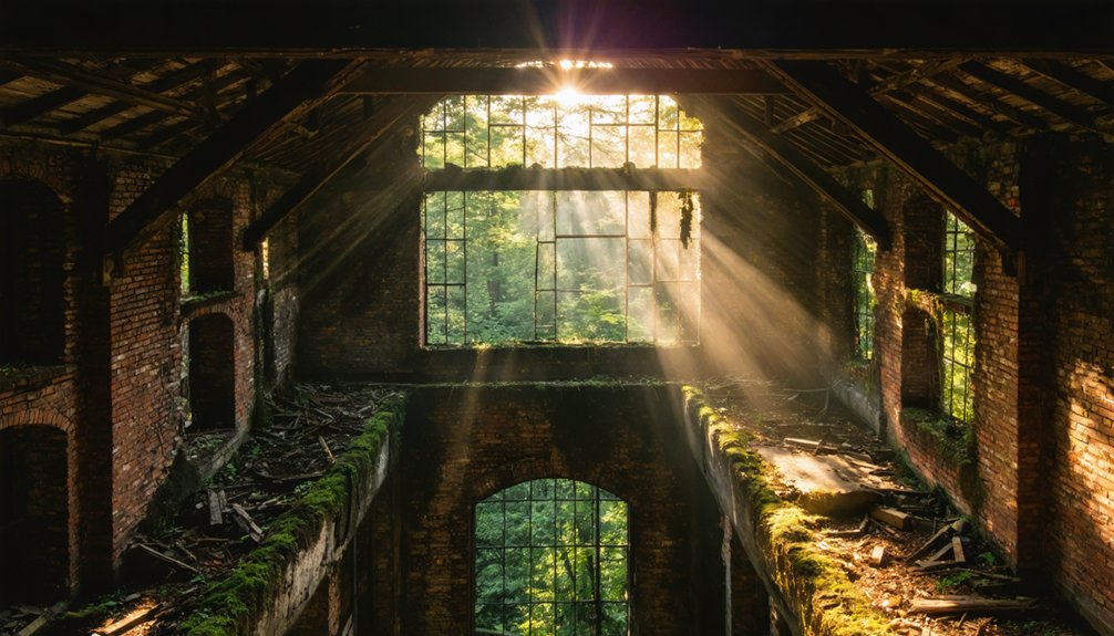
The Historic Ruins of Scull Shoals Mill Village
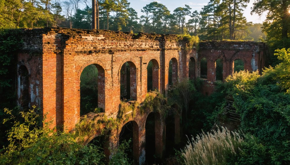
Deep in Georgia’s Oconee National Forest, the haunting ruins of Scull Shoals Mill Village stand as silent witnesses to a once-thriving industrial center.
You’ll find dramatic photo opportunities among the three towering brick walls of the old warehouse, while the arched brick bridge and toll bridge remnants offer compelling leading lines for your aerial shots.
Navigate the site via Macedonia Road to capture the stone foundations, scattered chimney bases, and power plant ruins hidden throughout the woods.
For the most striking compositions, explore the moss-covered masonry along the riverbank and incorporate the prehistoric earthworks upstream into your wide-angle panoramas.
Plan your visit during daylight hours and pack essential gear – there aren’t any facilities at Scull Shoals.
Watch for unstable terrain and seasonal flooding when positioning your drone.
High Falls: Capturing Water and Remnants
From the remnants of a once-thriving 19th-century industrial center, you’ll find strategic vantage points to capture High Falls’ 135-foot cascade thundering down the Towaliga River.
Your drone can soar above the scattered powerhouse ruins and grist mill foundation while framing dramatic aerial compositions that contrast rushing water with weathered stone structures.
When shooting near the falls, maintain safe distances from wildlife like deer and foxes while positioning your equipment on stable ground at elevated overlooks, especially during golden hour when sunlight amplifies the interplay between water motion and historic textures.
Dynamic Rapids Meet History
Thundering cascades of the Towaliga River create a dramatic backdrop for High Falls’ abandoned industrial ruins, where Georgia’s largest middle-state waterfall drops 135 feet through a series of rapids and shoals.
These dynamic contrasts between calm lake waters and rushing falls provide perfect conditions for capturing compelling historical narratives through your drone’s lens.
- Frame your shots using the old grist mill foundations against waterfall backdrops for powerful scale compositions.
- Capture the partially intact dam and whitewater patterns during golden hour for dramatic leading lines.
- Position your drone to showcase tree-lined river corridors with layered ruins-rapids-falls compositions.
- Exploit seasonal flow variations – spring’s intense rapids create high contrast shots, while fall’s calmer waters yield mirror-like reflections.
Safety and Vantage Points
Although High Falls State Park offers stunning aerial photography opportunities, you’ll need to secure proper permits and waivers before launching your drone at this historic site.
Submit your commercial filming application at least 10 business days ahead, including your FAA certification and specific project details.
For ideal drone safety, you’ll find designated vantage locations that keep you clear of populated areas while capturing the Towaliga River’s dramatic cascades.
The park’s scenic overlooks provide strategic launch points for documenting the interplay between rushing waters and historic ruins.
Position your drone to showcase the dynamic rapids alongside remnant structures, creating compelling compositions that tell Monroe County’s forgotten stories.
Remember to wrap up aerial operations by 10 p.m. and maintain safe distances from park guests and service animals.
Hidden Gems: Small Forgotten Towns Like Mallory
While many of Georgia’s ghost towns lie hidden in plain sight, Mallory stands as one of the state’s most intriguing abandoned settlements. Its historical significance stretches back to the early 1900s when 2,000 residents called this thriving community home.
Today, you’ll find compelling abandoned architecture scattered throughout the landscape, just ten minutes from Madison.
- Start at the historical marker near the Mallory family graveyard, your gateway to exploring these haunting ruins.
- Venture 300 yards from the main house to discover a preserved outbuilding, likely a former slave dwelling.
- Follow the backroad past the initial relics to reach the main settlement area.
- Capture unique angles of the grist mill and cotton gin remains that blend seamlessly into the surrounding wilderness.
Best Times and Weather Conditions for Ghost Town Drone Shots
Capturing remarkable ghost town drone footage demands precise timing and weather awareness to enhance the haunting beauty of these abandoned places.
You’ll find the golden hour‘s warm light and long shadows perfect for highlighting weathered textures and architectural details, while blue hour creates moody silhouettes against Georgia’s twilight sky.
Plan your flights during late autumn or winter when bare trees reveal hidden structures and improve sightlines for complex shots.
Late autumn’s leafless canopy offers unobstructed views of forgotten places, making it prime season for ghost town drone photography.
After rainfall, saturated colors and reflective puddles add drama to your compositions, but watch for unstable surfaces.
For the cleanest aerial footage, launch your drone during periods of light fog or when cloud cover diffuses harsh midday sun.
Always monitor wind conditions and avoid gusty weather that could compromise your drone’s stability and your shot’s clarity.
Post-Processing Tips for Abandoned Site Photography
Masterful post-processing transforms raw ghost town footage into compelling visual narratives of Georgia’s abandoned past.
You’ll need specific tonal adjustments to capture the haunting essence of these forgotten places, from crumbling antebellum mansions to deserted mining settlements.
- Establish a consistent color palette using split toning – cool shadows for mystery in darker building interiors, warm highlights for Georgia’s harsh sunlight striking weathered surfaces.
- Apply selective exposure blending to balance bright southern skies against shadowy structural details.
- Enhance texture selectively on decay patterns while preserving authentic patina – perfect for highlighting Appalachian stone foundations and rusted metal.
- Remove modern distractions like utility lines or recent trash, but retain historical elements that tell the story of these abandoned communities.
Planning Your Ghost Town Drone Photography Trip
Before launching your drone over Georgia’s historic ruins, careful preparation will maximize your chances of capturing compelling aerial footage while staying within legal bounds.
Start by securing your FAA registration for drones over 0.55 lbs and checking park-specific permits, especially for sites like Scull Shoals in Oconee National Forest.
Time your visits strategically – spring mornings at Old Car City’s 34 acres offer stunning vegetation contrast, while fall brings clear skies perfect for mill photography.
Pack your gear thoughtfully with spare batteries and waterproof equipment for riverside locations.
When mapping your route, consider an efficient circuit from Atlanta: hit Rome’s water wheel, White’s Old Car City, and Sparta’s red mill in one day.
Scout designated drone zones and stay mindful of the 15 mph wind threshold for stable footage.
Frequently Asked Questions
How Do You Protect Drones From Wildlife Encounters at Abandoned Sites?
In areas with 172 residents like Haralson, you’ll need heightened wildlife awareness. Use propeller guards, maintain 400+ feet altitude, install anti-collision lights, and scout locations pre-flight for ideal drone safety.
Can I Sell Prints of Ghost Town Drone Photos Online?
You can sell your drone prints through online marketplaces like Etsy or Redbubble, where you’ll maintain creative control while they handle printing and shipping. Set your prices and earn passive income from your photography.
What Backup Equipment Should I Bring to Remote Ghost Towns?
Like a well-stocked explorer’s pack, you’ll need spare batteries, portable charger, backup SD cards, repair tools, GPS tracker, prop guards, and first-aid kit for those haunting drone missions.
Are There Ghost Town Photography Groups or Communities in Georgia?
You’ll find active ghost town photography clubs throughout Georgia, including Atlanta Photography Group, Georgia Camera Club Council, and regional Meetup groups that organize regular urbex outings to abandoned locations.
How Do You Handle Unexpected Visitors While Filming at Abandoned Locations?
Stay aware of your surroundings, maintain clear exit routes, and keep permits handy. When unexpected encounters occur, calmly identify yourself, show documentation, and follow safety protocols. Don’t hesitate to leave if threatened.
References
- https://www.jimzuckerman.com/abandoned-in-georgia-2025
- https://www.new-east-archive.org/features/show/8852/georgia-by-drone-spectacular-flight-caucasian-landmarks-amos-chapple
- https://www.youtube.com/watch?v=hW4R7F_l9cM
- https://www.fireflymadison.com/2022/08/31/ghost-towns-in-georgia/
- https://www.youtube.com/watch?v=i4LWmtIOmt4
- https://www.youtube.com/watch?v=Oa7Ehjx4RZ8
- https://everafterinthewoods.com/georgia-ghost-town-landscapes-where-nature-and-history-share-the-same-ground/
- https://myfamilytravels.com/georgia-towns-and-locations-the-walking-dead-made-famous/
- https://www.ezhomesearch.com/blog/ghost-towns-in-georgia/
- https://www.youtube.com/watch?v=hicbcyTaJGY