You’ll find Idaho’s most photogenic ghost towns scattered across dramatic mountain and desert landscapes, perfect for aerial photography. White Knob offers stunning alpine panoramas, while Grasmere’s desert ruins create haunting compositions against sand dunes. Don’t miss Silver City’s 70 preserved structures or Burke’s narrow canyon with its cliffside ruins. For the best shots, launch your drone during golden hour when the light paints these abandoned frontiers in rich, warm tones. These five locations hold countless untold stories waiting to be captured from above.
Key Takeaways
- Silver City offers 70 original structures and an impressive skyline above Jordan Creek, making it Idaho’s most photogenic ghost town.
- Burke’s dramatic canyon setting provides unique aerial perspectives of mining structures clinging to steep walls and cave dwellings.
- White Knob features scenic mountain panoramas and historic mine sites best captured during golden hour lighting conditions.
- Bonanza’s scattered mill ruins and cemetery create compelling compositions against forested slopes and industrial landmarks.
- Grasmere presents haunting aerial opportunities with deteriorating structures against sand dunes, accessible via 2WD roads year-round.
Discover White Knob’s Mountain Panoramas
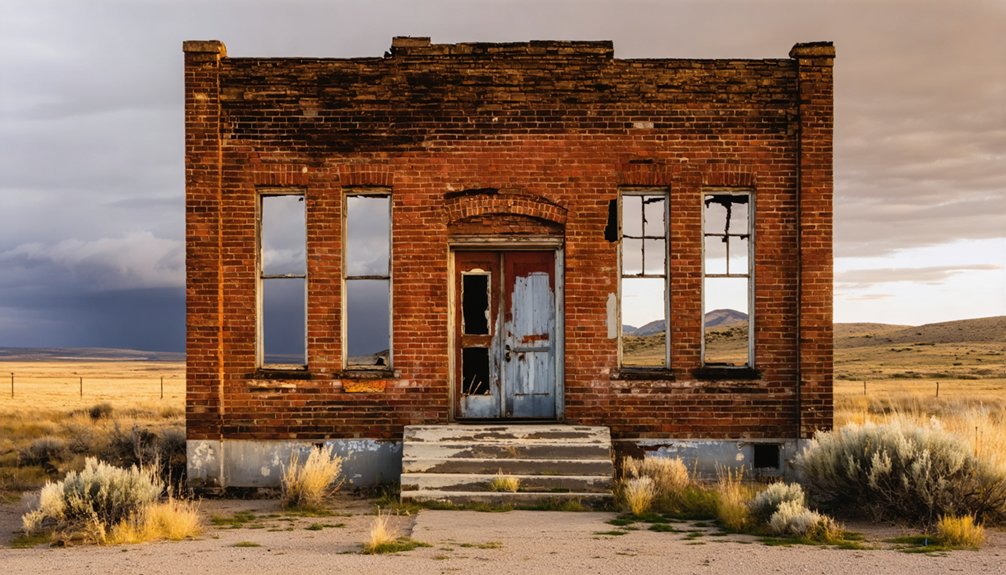
Perched high above the town of Mackay in Idaho’s Custer County, White Knob ghost town offers drone photographers an epic mountain playground for capturing sweeping panoramas.
With its commanding mountain views, White Knob ghost town beckons aerial photographers to capture Idaho’s rugged wilderness from above.
You’ll discover prime shots along the historic mine tram and mill sites, where steep ridgelines create dramatic vertical relief for your compositions.
For ideal landscape composition, position your drone to frame the Alberta Level tunnel and powerplant ruins against the White Knob Mountains backdrop during golden hour.
The Oregon Short Line provided rail access to transport copper ore from these historic mining operations.
Due to active mining operations resuming in the area, be sure to check current access conditions before visiting.
Access the area via unpaved roads with your RZR or ATV, but remember to verify property permissions and FAA regulations before launch.
The best seasonal windows come in early summer with snow-capped peaks or fall’s golden vegetation.
The site’s high elevation demands careful drone safety planning – watch for gusty winds near ridge lines and maintain conservative clearances around dilapidated structures.
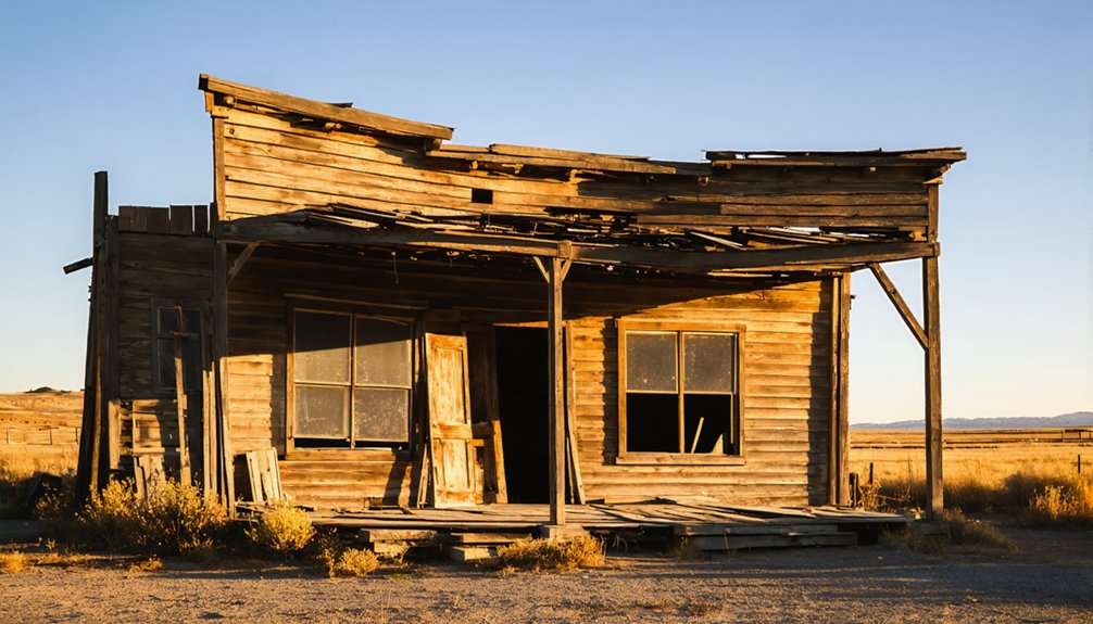
Grasmere: A Desert Ghost Town From Above
From mountain heights to desert solitude, you’ll find an entirely different drone photography challenge at Grasmere ghost town in Idaho’s Owyhee County.
This remote desert outpost, accessible via 2WD roads from I-84, offers spectacular opportunities for ghost town exploration with your drone. The site’s former gas station served as the only fueling point between Bruneau and Owyhee until its closure in 2005. You’ll capture haunting aerial shots of deteriorating structures against vast sand dunes, while documenting the striking aerial graffiti art that now covers the largest building. Like Land of the Yankee Fork State Park, the area preserves a crucial piece of Idaho’s mining heritage.
- Launch during golden hour to capture dramatic shadows across the cement-walled ruins
- Watch for cattle crossing the open range while setting up your gear
- Position your drone to frame both the abandoned gas station and nearby desert canyons
- Scout spring through fall when weather conditions are ideal for flying
Capturing Bonanza’s Mining Legacy
You’ll find some of Idaho’s most dramatic ghost town photography at Bonanza’s scattered mill ruins, where crumbling foundations contrast beautifully against forested mountain slopes.
To enhance your experience, consider these astrophotography tips for Idaho ghost towns, which can help you capture the stunning night skies above these historical sites. Utilize long exposure techniques to highlight star trails and the Milky Way, creating a mesmerizing backdrop that complements the eerie landscapes. Additionally, scouting locations during the new moon phase can provide the darkest skies, perfect for capturing the essence of these abandoned places.
Exploring ghost towns in Idaho’s film history allows you to step into the scenes where filmmakers have captured the haunting beauty of these forgotten places. Many of these towns have served as backdrops for renowned films, lending an air of authenticity to the cinematic experience. As you wander through the remnants of past lives, you can imagine the stories that unfolded here, further enriching your adventure in the Idaho wilderness.
The site’s weathered log cabins and mining infrastructure create compelling leading lines that you can capture from multiple drone angles, especially during golden hour when shadows accentuate the historic textures.
Today, only seven structures remain as a stark reminder of this once-thriving mining town.
For a particularly evocative shot, position your drone above the abandoned cemetery, where isolated grave markers tell silent stories against the rugged Yankee Fork landscape. The haunting remnants of two devastating fires in 1889 and 1897 add an extra layer of historical intrigue to aerial compositions.
Scenic Mountain Mill Remnants
Deep within Idaho’s rugged Yankee Fork valley, Bonanza’s historic mining remnants offer drone photographers an extraordinary combination of industrial heritage and alpine scenery.
The once-thriving settlement reached its peak with over 600 residents in 1881 before gradually fading into a ghost town.
The Sunbeam Dam remains a notable landmark showcasing the area’s industrial past.
You’ll find ghost town aesthetics perfectly framed against dramatic mountain backdrops, where the massive Yankee Fork Gold Dredge stands as a symbol of the area’s mining legacy.
For capturing stunning industrial landscapes, here are your prime shooting locations:
- The 988-ton floating dredge during golden hour, when sunlight catches its steel framework
- Geometric patterns of tailing fields from above, creating striking abstract compositions
- Sunbeam Mine headworks against snow-capped peaks for scale and contrast
- River corridors and processing ruins during morning fog, adding mystery to your aerial shots
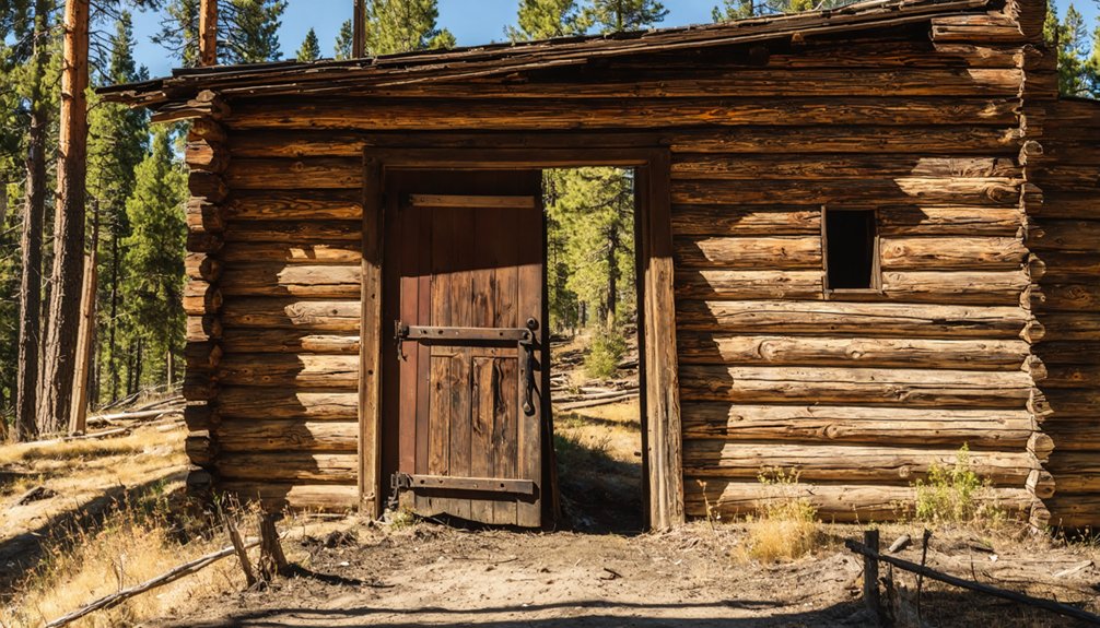
Historic Log Cabin Structures
While the dredge dominates Bonanza’s skyline, the settlement’s true character lies in its weathered log cabins – original structures that have endured over 140 years of mountain seasons.
You’ll find these hand-hewn treasures scattered along three bridge crossings of Yankee Fork, where early miners built their homes for $40-300 per lot back in 1877. Your drone can capture the authentic mining heritage through aerial shots of shake roofs and community wells that tell the story of frontier ingenuity.
For the best log cabin restoration footage, position your drone to frame the surviving structures against the gentle hills.
The town’s layout, with its tree-lined streets and original fire protection systems, offers unique perspectives on how these pioneers created a thriving community at 6,300 feet elevation.
Abandoned Cemetery Drone Views
Perched above the rugged Yankee Fork terrain, Bonanza’s historic cemetery offers drone photographers a poignant window into the area’s mining heritage. Through aerial storytelling, you’ll capture the raw essence of 19th-century frontier life, where weathered headstones tell tales of miners, families, and untold stories spanning from 1849 to 1929.
- Scout the cemetery during golden hour for dramatic side-lighting that creates long shadows across the headstones.
- Frame wide shots to include surrounding mountain slopes, using natural lines to guide viewers’ eyes.
- Incorporate nearby ghost town structures to establish visual connections with cemetery symbolism.
- Maintain respectful altitude when shooting, avoiding low passes over individual graves while focusing on patterns and geometric compositions that showcase the site’s historical significance.
The wooden markers and fences throughout the cemetery create striking geometric patterns when viewed from above, offering unique compositional opportunities for aerial photographers.
The area’s resident mountain goats can often be spotted navigating the rocky terrain near the cemetery, adding a compelling layer of wildlife interest to your aerial photography.
Remember to secure necessary permissions and follow FAA regulations before launching your drone.
Aerial Views of Historic Custer
Situated along Idaho’s Yankee Fork, Historic Custer offers drone photographers an ideal blend of preserved mining-era architecture and dramatic mountain terrain.
You’ll find this 1879 ghost town’s single-street layout creates perfect leading lines for your aerial shots, while restored buildings and mining equipment provide rich textural elements.
Access the site via Highway 75’s gravel road or the rugged Custer Motorway, using the Yankee Fork Gold Dredge as your staging point.
For the best drone techniques, plan low-altitude passes during golden hour when shadows accentuate the town’s historic structures.
Consider seasonal timing – winter snow amplifies contrast while summer greenery adds depth to your compositions.
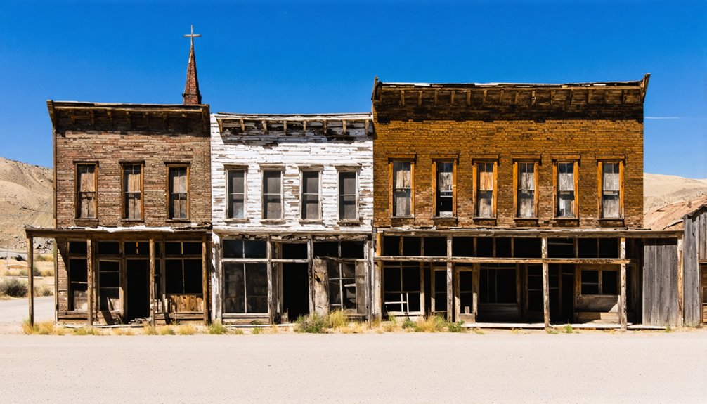
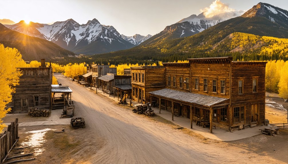
Silver City’s Preserved Architecture
A treasure trove of 70 original structures makes Silver City one of America’s most photogenic ghost towns for drone pilots.
You’ll discover preserved buildings perched on hillsides above Jordan Creek, creating an impressive skyline that’s perfect for aerial photography.
The ghost town architecture remains uncommercial and authentic, giving your footage a genuine Old West feel.
- Capture the Idaho Hotel’s 19th-century charm from above, showcasing its historical significance.
- Frame the mountaintop church against the rugged landscape for dramatic aerial shots.
- Document the Masonic and Odd Fellows halls, which tell stories of the town’s social life.
- Scout the vintage ore carts and tram buckets in the town center for unique industrial details.
Remember to respect private property and no-trespassing signs while getting your perfect shot.
Burke’s Mountain-Side Ruins
You’ll discover remarkable drone photography opportunities among Burke’s mountain-side ruins, where abandoned mining structures and historic buildings cling dramatically to the steep canyon walls.
Your aerial shots can capture the massive Hecla Mine complex towering above the narrow canyon floor, offering compelling perspectives of this once-bustling silver boom town.
Access points near I-90 provide unobstructed flight paths for capturing both the skeletal remains of the famous Tiger Hotel site and the sprawling industrial archaeology that makes Burke one of Idaho’s most photogenic ghost towns.
Dramatic Mountain Slope Architecture
The narrow canyon walls of Burke frame one of North America’s most compelling ghost town perspectives for drone pilots.
You’ll find mountain slope architecture that’s built right into the terrain, with terraced building placements that create dramatic vertical compositions against the rugged landscape.
- Capture multi-story commercial blocks with exposed basements and dramatic facades perfect for golden-hour light
- Frame structures spanning the old railroad tracks, where buildings cantilever over the historic corridor
- Scout cave-like dwellings cut into the hillside that create striking patterns when shot from above
- Look for massive stone and timber industrial ruins anchored on slope benches that contrast beautifully with the mountain textures
For the best shots, fly during early morning when shadows emphasize the layered architecture and remaining foundations that climb the canyon walls.
Historic Mining Equipment Remains
While exploring Burke’s rugged terrain, you’ll discover massive mining equipment remains that create striking aerial compositions against the mountain backdrop. The towering Hecla Mine structures dominate the canyon’s narrow 300-foot width, offering perfect angles for your drone to capture decades of industrial history.
Your aerial shots can showcase the stark contrast between deteriorating mining relics and the surrounding wilderness. Navigate your drone carefully around the remaining buildings to document ore processing sites and tailings piles that tell the story of Burke’s boom-and-bust cycle.
For the most dramatic footage, position your camera to capture the scale of these mountain-side ruins against Canyon Creek below. Remember to maintain safe distances from unstable structures and keep your drone away from any mine openings or compromised infrastructure.
Aerial Photography Access Points
For ideal drone launches in Burke, establish your base at the Interstate 90 exit near Wallace before heading north on Highway 4.
You’ll find dramatic aerial opportunities within the 300-foot-wide canyon, where stacked ruins create perfect vertical compositions against the Coeur d’Alene peaks.
- Launch your drone from the main road’s wide spots to capture the railroad’s path through building remnants, including the iconic Tiger Hotel where tracks once passed through the lobby.
- Position at 3,700 feet elevation for sweeping shots of cave dwellings carved into the mountainside.
- Set up near the mill ruins for overhead patterns of twisted tracks and industrial remains.
- Scout the canyon’s narrowest points during daylight hours to master drone photography techniques while maneuvering through challenging terrain between towering walls.
Frequently Asked Questions
What Drone Permits Are Required for Ghost Town Photography in Idaho?
You’ll need your FAA Remote Pilot Certificate for commercial shots, drone registration if over 250g, TRUST certification for hobby flights, plus local airspace permits and land-use authorizations from BLM or USFS.
How Do Weather Conditions Affect Drone Flights in These Locations?
You’ll battle extreme weather patterns at these high-altitude ghost towns, where winds can ground your drone instantly. Watch for icing above 6,000 feet and expect shorter battery life in cold temperatures.
Are There Seasonal Restrictions for Accessing These Ghost Towns?
You’ll find seasonal access heavily restricted during winter months. Most ghost town accessibility peaks from late spring through early fall, when mountain passes and forest roads are clear.
Which Drone Batteries Perform Best in High-Altitude Ghost Town Locations?
Time is money, so don’t skimp on power. You’ll want high-capacity Li-ion packs for extended mountain flights, while cold-rated 6S batteries combat altitude effects and maintain performance in thin mountain air.
What Is the Best Time of Day for Ghost Town Drone Photography?
You’ll get your most dramatic shots during golden hour – especially 30-60 minutes before sunset. The warm light casts long shadows across abandoned structures, and you’ll capture stunning sunset shots with minimal glare.
References
- https://www.rusticlens.com/2017/09/04/white-knob-idaho-ghost-town-near-mackay-idaho/
- https://www.youtube.com/watch?v=jbamjKNXPIY
- https://www.youtube.com/watch?v=RNCaxrY62ZI
- https://idaho-forged.com/idahos-ghost-towns-eerie-yet-approachable/
- https://www.atlasobscura.com/places/burke-ghost-town
- https://www.youtube.com/watch?v=P2JgcghKPKQ
- https://www.worldatlas.com/cities/10-most-eccentric-towns-in-idaho-2025.html
- https://visitidaho.org/things-to-do/ghost-towns-mining-history/
- http://www.hisandhersphoto.com/ghost/hhwhite.htm
- https://www.youtube.com/watch?v=l9n6yC2KNbQ