
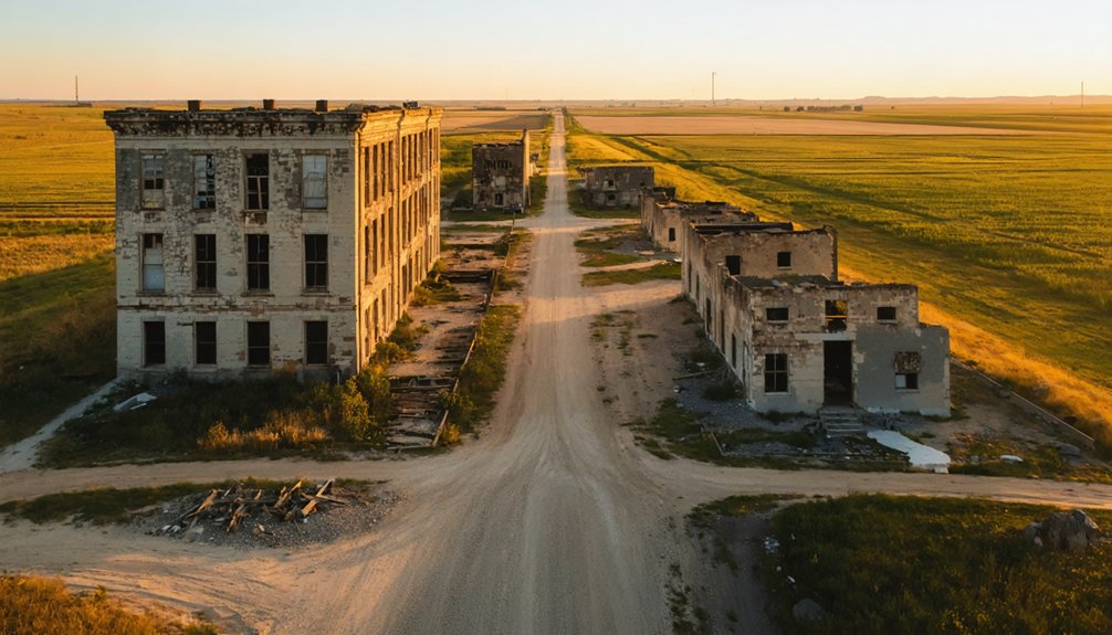
You’ll find Kansas’s most photogenic ghost towns scattered across the prairie, where stone markers in Irving and Bigelow offer perfect launch sites. The Marion County Poor Farm’s flat terrain and historic structures create dramatic aerial compositions, while Geuda Springs’ healing salt springs add mystical elements to your shots. Capture golden hour light at Riverdale and Belle Plaine, where convenient roadside pull-offs make deployment easy. These abandoned settlements hold countless stories waiting to unfold through your drone’s eye view.
As you explore the best ghost towns in Kansas, don’t miss out on the eerie charm of the once-bustling community of Nicodemus, a significant part of African American history. Each dilapidated building tells a story of resilience and change, providing a haunting backdrop for your explorations. Remember to stop by the majestic ruins of the old railroad towns that once connected this vibrant state to the rest of the country.
Key Takeaways
- Irving and Bigelow offer stone markers and open fields, providing excellent vantage points for aerial photography of historic ruins.
- Marion County Poor Farm features flat terrain and historic structures, making it ideal for dramatic drone shots.
- Riverdale and Belle Plaine provide convenient roadside access and safe launch zones for capturing abandoned buildings.
- Geuda Springs combines historic healing salt springs with open spaces, creating unique opportunities for aerial documentation.
- Golden hour lighting at these locations enhances the contrast between nature and decay, producing striking ghost town imagery.
Finding Safe Drone Launch Sites Near Ghost Towns
When exploring Kansas ghost towns with your drone, finding the perfect launch site requires careful consideration of both safety and legal requirements.
You’ll discover ideal launch site selection opportunities at stone markers in Irving and Bigelow, where open fields and picnic areas provide unobstructed takeoff zones.
The Marion County Poor Farm area offers flat terrain adjacent to historic structures, while Riverdale and Belle Plaine feature convenient roadside pull-offs perfect for drone deployment.
The historic grounds of Marion County welcome drone pilots with level launch zones, while nearby ghost towns provide accessible staging areas.
Near Geuda Springs, you can utilize the areas around the healing salt springs while documenting the remnants of this once-thriving town.
For enhanced rural accessibility, seek out the wide shoulders along county roads near Canada, Kansas, or explore the elevated positions at Oxford’s roadside hillsides.
Near Bushong, Kansas, where 134 residents once lived, you’ll find expansive open areas away from the World War II memorial for safe drone operations.
Remember to maintain a 100-foot buffer from any structures, and always scout for hazards like power lines or farm equipment before launch.
Keep your FAA Part 107 certification handy and stay below 400 feet for safe, legal operations.
Aerial Photography Tips for Abandoned Buildings
With your launch site secured, mastering aerial photography of abandoned buildings demands both technical skill and artistic vision. Your drone’s eye view reveals weathered building textures and architectural details often missed from the ground. Consider exploring during daylight hours to ensure optimal visibility and safety when navigating your drone. Bring a trusted companion to assist with equipment and enhance overall safety during the shoot.
Let nature’s light guide your aerial perspectives, especially during golden hour when shadows stretch across forgotten structures.
- Position your drone low and close to walls for dramatic upward angles that emphasize scale and decay.
- Use manual exposure settings in high-contrast situations, typically f/8 for sharp details.
- Frame symmetrical shots from above, letting surrounding vegetation tell the story of nature’s reclamation.
- Capture leading lines of rooftops, walkways, and foundations to draw viewers into your composition.
Remember to experiment with different heights and angles while maintaining safe distances from structures – each elevation offers unique storytelling opportunities.
Essential Gear for Kansas Ghost Town Documentation
Successful ghost town documentation in Kansas requires a carefully curated gear setup that balances mobility with technical capabilities.
Your camera selection should center on the Nikon D810 paired with a 20mm f/1.8 lens for crisp low-light captures, while the DJI Avata FPV drone lets you maneuver through tight spaces in deteriorating structures. The Rock Steady stabilization ensures smooth footage even in challenging conditions.
Master lighting techniques by mounting Lume Cubes on your drones to paint abandoned buildings section by section. The separate light exposures will help achieve optimal image quality during post-processing.
You’ll want multiple batteries for extended shoots, especially when capturing both illuminated architecture and starlit skies. The compact FPV kit proves invaluable when traversing through collapsed roofs and forgotten corridors.
Don’t forget to scout locations beforehand using Google Earth – it’s your window into these time-frozen landscapes before you ever launch your first flight.
Weather Considerations for Ghost Town Drone Flights
Flying drones through Kansas ghost towns demands a sharp eye on the turbulent Plains weather patterns that can transform calm skies into threatening storms within minutes.
You’ll need robust storm tracking skills to capture those haunting ruins safely while maneuvering through the state’s dramatic weather. Clear communication with your drone team about weather changes is essential for everyone’s safety.
- Watch for thunderheads building in the west – those massive storm formations visible in Howard can spawn lightning that’ll light up your ghost town shots but threaten your gear.
- Monitor tornado preparedness alerts – EF0 winds of 75mph will ground your drone instantly.
- Track seasonal patterns – spring peaks for tornadic activity, while summer brings spectacular lightning storms.
- Check weekly forecasts – Plains storms roll through abandoned towns year-round, creating dynamic shooting conditions but requiring constant vigilance. The devastating EF3 tornado in Andover proved how quickly Kansas storms can develop and intensify, so always maintain emergency landing protocols.
Best Times of Day for Ghost Town Aerial Shots
The ghostly facades and weathered ruins of Kansas’ abandoned towns reveal their most enchanting secrets during nature’s magical hours.
Like silent sentinels frozen in time, Kansas’ forgotten places whisper their stories when touched by nature’s ethereal light.
You’ll capture the most striking aerial imagery during golden hour, when the sun’s warm rays paint forgotten structures in rich amber tones and cast long, dramatic shadows across the plains.
For a more mystical atmosphere, venture out during blue hour just before sunrise, when the cool, ethereal light bathes decaying buildings in serene indigo hues. Setting up your drone with low ISO settings during these darker conditions will help minimize noise in your shots.
For a more mystical atmosphere, venture out during blue hour just before sunrise, when the cool, ethereal light bathes decaying buildings in serene indigo hues.
Avoid mid-day flights between 10am and 3pm when harsh sunlight washes out details and creates unflattering shadows. Consider using light-colored reflectors to enhance detail in shadowy areas when shooting during these hours.
Instead, plan your drone adventures for dawn’s first light or dusk’s fading glow, when Kansas’ ghost towns transform into hauntingly beautiful subjects beneath the prairie sky.
Legal Requirements for Drone Photography in Historic Sites
Before launching your drone to capture Kansas’ historic ghost towns, you’ll need to navigate a complex web of federal, state, and local regulations that protect these precious sites.
The thrill of documenting these forgotten places from above comes with responsibility to preserve their historic integrity.
- You must obtain your Remote Pilot Certificate for commercial shots or pass the TRUST test for recreational flights – these historic treasures demand proper credentials.
- Keep your drone under 400 feet and within visual line of sight while capturing those weathered structures.
- Secure airspace authorization if you’re near airports, and check local ordinances that might restrict flights over specific ghost towns.
- Get necessary permits from site managers or property owners – many historic locations require special permission to protect these time-worn remnants from modern intrusion.
Planning Multi-Site Ghost Town Flight Routes
Mapping out a multi-site ghost town expedition requires careful orchestration of timing, light, and logistics to capture Kansas’ abandoned settlements in their most haunting beauty.
Among the most intriguing destinations are the abandoned film sets in Kansas, remnants of bygone productions that evoke a sense of nostalgia. Each site tells a story, with crumbling facades and rusting props serving as poignant reminders of creativity and ambition. Exploring these eerie locations reveals not only the artistic endeavor but also the passage of time, capturing the essence of forgotten narratives.
You’ll want to maximize your route optimization by clustering sites with complementary features – maybe a weathered mill in one town paired with a stark church steeple in the next.
For the most dramatic shots, plan your site prioritization around golden hour, moving east to west as the sun tracks across the prairie sky.
Scout your staging areas in advance, marking safe launch zones near each ghost town’s most striking structures. Keep alternate locations within a 30-minute radius in case weather shifts or access changes.
Pack plenty of spare batteries and props – out here, you won’t find a drone shop around the corner.
Frequently Asked Questions
How Can I Identify Which Structures Are Too Unstable for Close Drone Approaches?
You’ll spot unsafe structures by checking for leaning walls, sagging roofs, crumbling foundations, and extensive cracks. Keep your drone at least 50 feet back when these structural assessment red flags appear.
What Local Authorities Should I Contact Before Filming Ghost Town Properties?
You’ll need to contact the county clerk, sheriff’s office, and city planning department to review local regulations and filming guidelines. Secure permits and check historic preservation rules before launching your drone.
Are There Seasonal Changes That Make Certain Ghost Towns More Photogenic?
You’ll capture stunning seasonal lighting in spring when foliage frames ruins, while winter’s stark weather conditions expose hidden structures. Fall’s golden hours and autumn leaves create especially dramatic drone compositions.
How Do I Handle Curious Onlookers While Conducting Drone Photography Sessions?
Like a skilled conductor, orchestrate your shoot by having a spotter engage curious locals with respectful communication while you focus on flying. Post visible signs and maintain a professional, friendly demeanor.
Which Ghost Towns Have Restricted Access Requiring Special Filming Permits?
You won’t find restricted access or special filming permits required at Bushong, Canada, Marion County Poor Farm, or Aulne. They’re all freely accessible for your aerial photography adventures.
References
- https://www.youtube.com/watch?v=ie3zwwHm2Jg
- https://www.youtube.com/watch?v=OyBXD18P_j4
- https://www.travelks.com/kansas-magazine/articles/post/exploring-kansas-forgotten-roads/
- https://www.youtube.com/watch?v=iB5rHT14eVI
- https://www.youtube.com/watch?v=dF7vGl5xasI
- https://www.onlyinyourstate.com/experiences/kansas/kansas-ghost-towns
- https://www.ripearts.com/journal/how-to-find-and-photograph-abandoned-buildings
- https://contrastly.com/how-to-photograph-models-in-abandoned-buildings/
- https://digital-photography-school.com/how-to-photograph-abandoned-places/
- https://www.youtube.com/watch?v=8q349IJEQu0


