You’ll find Maryland’s most dramatic ghost town photography at Daniels’ crumbling church ruins, Fort Carroll’s deteriorating ramparts, and Curtis Creek’s mysterious ghost fleet. Pack your DJI Mini 4 Pro with spare batteries and ND filters for golden hour shoots above these historic sites. Western Maryland offers abandoned mining remnants in Georges Creek Valley, while Lonaconing’s industrial ruins create striking compositions. These forgotten places hold countless aerial perspectives waiting to be discovered.
Key Takeaways
- Daniels offers dramatic aerial shots of Saint Stanislaus Kostka Church ruins and hidden cemetery graves dating from 1912-1919.
- Curtis Creek features a ghost fleet of WWI-era ships perfect for dawn photography with compelling cross-sections of decaying vessels.
- Fort Carroll’s hexagonal fortress on an artificial island provides unique aerial perspectives of deteriorating ramparts and seabird colonies.
- Georges Creek Valley contains historic 1820s mining sites with Lonaconing’s ruins offering striking compositions in morning light.
- Fort Howard presents abandoned military structures and coastal views ideal for dramatic sunrise and sunset drone photography.
Essential Gear and Pre-Flight Planning
When venturing into Maryland’s ghost towns for drone photography, you’ll need to assemble a thorough gear setup that balances portability with professional capability.
The DJI Mini 4 Pro offers 34 minutes airtime per battery, making it an excellent choice for ghost town exploration. Start with a high-quality drone featuring a 3-axis gimbal, pack at least two spare flight batteries, and carry fast UHS-I U3 microSD cards for reliable 4K capture. Proper gear maintenance includes keeping your ND filters clean and protected in a weatherproof case.
Smart battery management is vital in these remote locations. Pack a charging hub, fire-resistant LiPo bag, and portable power station for extended shoots. A pre-flight checklist the day before ensures you won’t forget critical equipment.
Power up wisely in remote ghost towns – bring backup batteries, charging hubs and fire-safe storage for successful extended missions.
Before takeoff, verify your flight permissions, check local airspace restrictions, and scout for hazards like power lines and unstable structures.
Don’t forget your landing pad and basic repair kit – they’re essential when shooting in Maryland’s rugged abandoned sites.
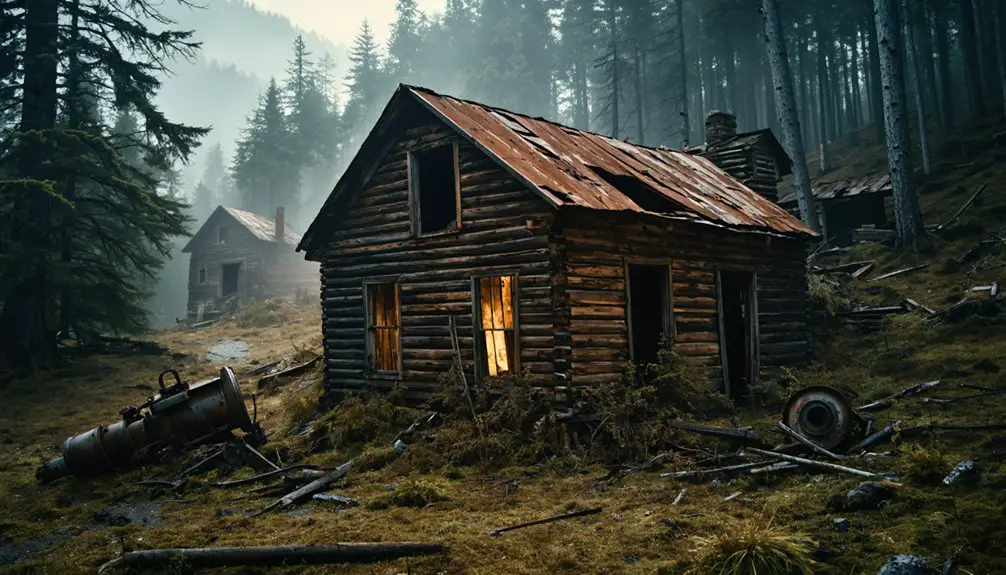
Discovering the Haunting Beauty of Daniels
With your gear packed and pre-flight checks complete, Daniels stands ready to tell its haunting story through your drone’s lens. This former mill town’s history stretches back to 1810, evolving from Elysville to Alberton before its final identity as Daniels. Originally founded by Thomas and Joseph Ellie, the town grew into a thriving industrial community.
You’ll find architectural relics scattered throughout the valley – from the haunting ruins of Saint Stanislaus Kostka Church to crumbling mill foundations and flood-stranded vehicles. The site’s hidden cemetery graves date from 1912 to 1919, adding to its mysterious atmosphere.
Tropical Storm Agnes delivered the final blow in 1972, washing away most structures and cemetery markers. Today, as part of Patapsco Valley State Park, the site offers compelling angles for aerial photography.
But watch for hazards – steep terrain, unstable masonry, and river canyon winds demand careful flight planning. Remember, you’re capturing a protected historic district, so maintain respectful distances from structures and follow park drone regulations.
Aerial Adventures at Fort Carroll and Fort Howard
A haunting hexagonal fortress rises from the Patapsco River’s waters near the Francis Scott Key Bridge – Fort Carroll, a photographer’s dream for unique aerial compositions.
You’ll need to navigate complex access constraints since the fort sits on a private artificial island with no public dock.
When flying your drone at Fort Carroll, stay vigilant of maritime traffic and bridge proximity. You’ll want to maintain visual line-of-sight while capturing the striking geometry of deteriorating ramparts and natural overgrowth.
The 3.4-acre man-made island stands as a testament to 19th-century coastal defense engineering.
The site offers compelling shots of seabird colonies and panoramic harbor views.
Designed by Robert E. Lee before his Civil War fame, the fort represents an ambitious military vision that never reached its full potential.
Remember to check FAA regulations, obtain necessary authorizations, and respect wildlife. Keep your drone at safe distances from nesting birds and shipping lanes.
Pack emergency flotation gear – water recoveries here are challenging if equipment fails.
Curtis Creek’s Maritime Ghost Fleet
You’ll find the century-old ghost fleet of Curtis Creek resting beneath the I-695 bridge, where dozens of wooden WWI-era freighters and concrete barges lie in various states of decay.
For the best drone shots, launch from the public access point near Sledds Point at dawn when the low-angle light casts long shadows across the rotting gunwales and exposed ribs of these maritime relics.
Your aerial photography can capture both the haunting cross-sections of these half-sunken vessels and the surrounding industrial landscape that contributed to their abandonment. Among these historic wrecks lies the famous three-masted schooner Parker, which mysteriously drifted unmanned from North Carolina to Maine in 1899.
Modern visitors can still spot the buried superstructures of these vessels beneath the surface during low tide.
Rusting Giants at Rest
Beneath the I-695 bridge spanning Curtis Creek, an extraordinary maritime graveyard tells the story of Baltimore’s forgotten fleet.
You’ll discover a diverse collection of vessels, from the legendary William T. Parker schooner – once known as Baltimore’s Flying Dutchman – to the Emma Giles, a former passenger ferry turned lumber barge.
As you pilot your drone through this maritime history treasure trove, you’ll capture dramatic shots of fifteen WWI-era wooden freighters partially submerged as breakwaters near Sledds Point. The abandoned vessels have become artificial habitats for local aquatic species.
The ecological transformation is striking – rotting hulls and peg-studded gunwales now serve as sanctuaries for migratory birds and marine life.
Navigate between Curtis Bay and Hawkins Point to document these rusting giants, accessing prime shooting locations by paddling through the industrial waterfront‘s shallow waters. Current environmental concerns include potential contamination from nearby sewage treatment plants affecting water quality in the area.
Aerial Access Points
Three prime launch points offer drone photographers strategic access to Curtis Creek’s maritime ghost fleet. The I-695 bridge provides an elevated vantage point for capturing the ghostly vessels below, while adhering to drone regulations over navigable waterways.
You’ll find the most versatile launch site at Jaws Marina on 6100 Chemical Road, though you’ll need to pay a small fee for access.
For close-up aerial photography of the deteriorating hulls, consider launching from a kayak or paddleboard in the creek’s shallow waters.
While industrial fencing restricts ground access around the shipyards and Coast Guard facility, your drone can easily document these maritime relics from above. The creek’s calm waters and relatively open airspace make it ideal for capturing dramatic shots of vessels like the legendary William T. Parker.
Dawn Light Photography Tips
While the ethereal atmosphere of Curtis Creek’s maritime ghost fleet captivates photographers year-round, the golden hour before sunrise offers unparalleled opportunities for dramatic drone photography.
You’ll want to arrive 30 minutes before sunrise to capture the striking shift from cool pre-dawn tones to warm golden light.
Position your drone at low angles (10-20 feet) to emphasize hull textures and create compelling dawn reflections in the calm water.
Exposure bracketing is essential – the dynamic range between bright skies and shadowed hulls demands careful management.
Monitor your color temperature settings as they’ll shift rapidly during the first 20 minutes of sunrise.
For maximum impact, compose shots that layer derelict vessels against the industrial shoreline, using leading lines from broken masts and rigging to draw viewers into your frame.
Hidden Mining Remnants of Western Maryland
As you explore Western Maryland’s ghost towns by drone, you’ll discover the richest concentration of historic mining sites along the Georges Creek Valley, where industrial ruins from the 1820s onwards tell a compelling story of the region’s coal heritage.
Your aerial photography can capture the dramatic legacy of this mining history, from collapsed mine portals to the skeletal remains of company infrastructure.
Through the drone’s eye, abandoned mine shafts and rusted industrial skeletons reveal Western Maryland’s coal mining past.
- Lonaconing’s iron works ruins and coal facilities offer striking compositions, especially with morning light hitting the weathered structures and rail remnants.
- Eckhart Hill’s surface scars reveal early pick-and-shovel mining patterns, creating abstract textures perfect for overhead shots.
- Upper Potomac corridor near Kitzmiller showcases preserved company store foundations and museum sites.
- Garrett County’s abandoned communities, like Dodson and Kempton, feature haunting coke ovens and mine portals hidden among regrown forests.
Before launching your drone to capture Maryland’s ghost towns, you’ll need to navigate a complex web of federal and state regulations that govern unmanned aircraft operations.
Exploring abandoned places in Maryland can provide a unique glimpse into the past, filled with rich history and intriguing stories. As you prepare for your aerial expedition, ensure your drone’s camera is ready to document the haunting beauty of these forgotten sites. Keep in mind that some locations may have restricted access, so always prioritize safety and respect the local regulations.
When seeking out ghost towns in Maryland for photographers, consider visiting the most picturesque spots that tell stories of their former life. Each site holds a unique charm, perfect for capturing stunning visuals that reflect the passage of time. As you explore, be sure to engage with fellow enthusiasts who share your passion for uncovering the beauty within decay.
Start by completing your TRUST certification and registering any drone over 0.55 pounds with the FAA. Since many ghost towns lie within state parks, you’ll need to contact the Park Manager for explicit permission before flying.
While local drone restrictions have been preempted by state law, you’ll still need to be mindful of controlled airspace, particularly near BWI Marshall and Martin State airports.
The good news is that Maryland doesn’t restrict drone flights over private property, though you’ll want to maintain reasonable distances to avoid nuisance claims.
Remember to stay under 400 feet and maintain visual line-of-sight while capturing these historic ruins.
Capturing Golden Hour Magic Above Ruins
The magical hour before sunset transforms Maryland’s ghost towns into ethereal landscapes perfect for drone photography.
The remnants of abandoned buildings create an intriguing backdrop, making them ideal ghost towns for film settings. Filmmakers often seek out these locations to capture the haunting beauty and sense of desolation they offer. Each site reveals unique stories waiting to be told through the lens, inviting creativity and exploration.
When golden light bathes decaying structures, you’ll discover unmatched opportunities for compelling ruin photography that captures both history and atmosphere.
- Position your drone at DanielsGhostTown’s church ruins during golden hour to catch long shadows stretching across crumbling walls and overgrown foundations.
- Orbit WinderbourneMansion’s Victorian turrets as warm light filters through broken windows, highlighting architectural details against darkening skies.
- Capture Curtis Creek’s haunting shipwrecks when low sunlight creates mirror-like reflections off still waters around rusted hulls.
- Frame Fort Armistead’s weathered tunnels as sunset rays penetrate through gaps, creating dramatic light-and-shadow contrasts perfect for moody aerial compositions.
These forgotten places come alive with stories when bathed in nature’s most cinematic lighting.
Frequently Asked Questions
What Wildlife Hazards Should Drone Pilots Watch for Around Maryland Ruins?
Watch for eagle collisions near reservoirs, deer startling in ghost towns, snake encounters at ruins, and swarms of insects that’ll interfere with your drone. Stay alert for wildlife encounters affecting flight safety.
How Do Weather Conditions Affect Drone Battery Life at Higher Elevation Sites?
You’ll see up to 40% less flight time at elevation, as thin air reduces rotor efficiency and cold temps drain batteries faster. Keep spare batteries warm and plan shorter flights above 1,000 feet.
Which Ghost Towns Offer the Best Winter Photography When Foliage Dies?
You’ll capture striking abandoned structures at Fort Howard and Daniels, where bare winter landscapes expose weathered ruins against stark backgrounds, enhancing dramatic aerial compositions without interference from dense summer vegetation.
Are There Seasonal Closures During Bird Nesting Periods Near Coastal Ruins?
You’ll face strict closures at coastal ruins from March through August during bird nesting periods, with federal and state authorities enforcing no-fly zones up to 1,000 feet around protected colonies.
What Backup Landing Sites Exist if Primary Locations Become Suddenly Inaccessible?
Like a modern Lewis and Clark, you’ll find alternative locations in nearby public parks, federally-designated recreational areas, and pre-approved private lots. Keep these mapped for emergency landings if ghost town access changes.
References
- https://thedronelifenj.com/places-to-fly-a-drone-in-maryland/
- https://www.tripadvisor.com/Attraction_Review-g41131-d10035193-Reviews-Daniels_Ghost_Town-Ellicott_City_Maryland.html
- https://www.youtube.com/watch?v=EJO3HoNmGjM
- https://www.youtube.com/watch?v=Y7geRdlxPMY
- https://wtop.com/charles-county/2016/08/drones-offer-birds-eye-glimpse-of-md-ghost-fleet/
- https://www.youtube.com/watch?v=dX40pW72g8I
- https://www.mdshooters.com/threads/ghost-towns-abandoned-buildings-scenic-areas-recommend.224547/
- https://digital-photography-school.com/drone-photography-checklist-printable/
- https://skylum.com/blog/drone-photography-for-beginners
- https://photographylife.com/drone-photography-accessories