You’ll find Oregon’s best drone photography at its 80+ ghost towns, with prime locations scattered across the central, eastern, and southern regions. Plan your shots during golden hour (30-60 minutes after sunrise or before sunset) for ideal lighting and minimal wind conditions. The Hardman-Eastern Grasslands route offers expansive aerial views, while the Willamette Valley showcases historic storefronts and rail remnants. Remember your FAA registration and B4UFLY app checks to access these haunting aerial perspectives.
Key Takeaways
- Hardman ghost town offers expansive grassland views ideal for drone shots, with well-preserved wooden structures and minimal obstacles.
- Golden ghost towns along the Willamette Valley provide stunning aerial opportunities of historic storefronts during sunrise and sunset.
- Ghost towns near covered bridges on Marcola Road combine architectural elements with natural scenery for compelling aerial compositions.
- Late summer visits provide extended golden hour photography windows of up to 21 minutes for optimal lighting conditions.
- Eastern Oregon ghost towns feature wide-open spaces and abandoned railway infrastructure, perfect for unobstructed drone cinematography.
Why Oregon Leads in Ghost Town Photography
While many states boast abandoned settlements, Oregon stands unrivaled as America’s ghost town capital with over 80 registered sites scattered across its diverse landscape.
Friendly locals make these towns even more appealing for photographers, as they often share personal stories and historical insights that add depth to your visual documentation.
You’ll discover these haunting remnants of the past primarily concentrated in the central, eastern, and southern regions, each telling a unique story of boom-and-bust cycles. Many of these locations are best visited during the summer months due to their high-elevation positions.
What makes Oregon’s ghost towns exceptional for photography is their diverse origins – from gold mining boomtowns in the south to lumber settlements and wool centers like Shaniko.
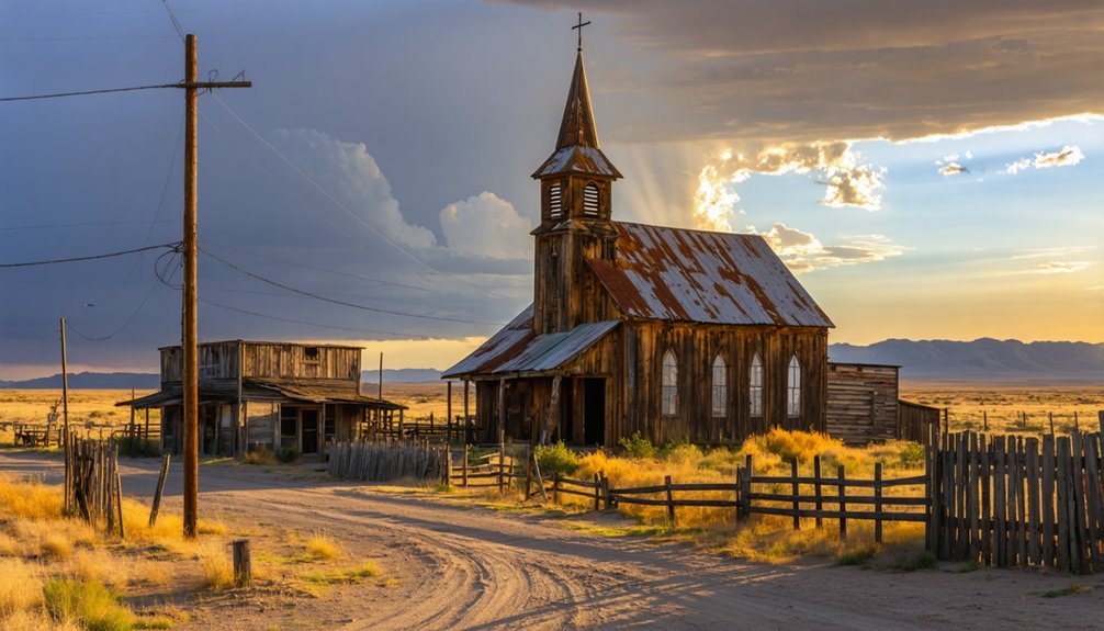
These sites offer you endless creative possibilities, especially for drone photography. Whether you’re capturing the preserved 1890s church in Golden or documenting the atmospheric ruins of former stage route stops, you’ll find authentic Wild West relics that perfectly showcase Oregon’s rich pioneer heritage through your lens.
Essential Drone Equipment and Permits
Before launching your drone to capture Oregon’s ghost towns, you’ll need to navigate essential FAA requirements and obtain proper documentation.
Start by registering your drone if it weighs over 0.55 pounds and complete your TRUST certification as a hobbyist. For commercial shoots, you’ll need your Part 107 license.
Remember: All drones over 0.55 pounds need FAA registration, plus TRUST certification for hobby flights or Part 107 for commercial work.
Your drone must have Remote ID capability, and you’ll want to download the B4UFLY app to check airspace restrictions around ghost town sites. Civil penalties up to $10,000 may apply for violations of Oregon drone regulations.
If you’re shooting in state parks, locate the designated Drone Operation Areas and check if you need a Drone Pass for that specific location. Park managers can restrict or suspend drone activities for wildlife protection at any time.
Remember that property owners can restrict flights under 400 feet, so research land ownership before planning your ghost town photography mission.
Best Times of Day for Ghost Town Aerial Shots
You’ll capture Oregon’s ghost towns at their most haunting during golden hour, when the sun’s low angle bathes abandoned structures in warm light perfect for drone photography.
For those looking to explore the cosmos, the best astrophotography spots in Oregon offer breathtaking views of the night sky. Locations such as Crater Lake National Park and the John Day Fossil Beds provide stunning backdrops for capturing star trails and the Milky Way. Don’t forget to check the lunar calendar to plan your visit during moonless nights for the best results.
For the best aerial shots, plan your flights during the 30-60 minutes after sunrise or before sunset, while avoiding the harsh shadows and flat lighting of midday. The soft, diffused shadows created during these times add depth to your ghost town scenes. Consider scheduling shoots 48 hours ahead to account for weather changes and ensure optimal conditions.
If you’re shooting in Oregon’s frequently cloudy conditions, you can take advantage of the natural diffusion to highlight architectural details and textures throughout the day.
Golden Hour Light Tips
As the sun approaches the horizon in Oregon’s ghost towns, capturing the perfect golden hour shot requires precise timing and an understanding of seasonal light variations.
You’ll find late-summer offers the most generous windows, with golden hour lasting up to 21 minutes after sunset, ideal for dramatic aerial compositions. In winter, you’re working with tighter 10-20 minute windows, so plan accordingly.
To maximize these light conditions, position your drone perpendicular to the sun for enhanced texture detail, or behind subjects for striking silhouettes. The soft, warm light creates stunning detail in abandoned structures without harsh shadows. Apps like Sun Seeker can help determine precise golden hour timing for your specific ghost town location.
Keep your ISO low (100-200) while light permits, and shoot RAW to preserve those warm tones.
For best results, use sun-tracking apps to plan your flight paths, and be ready to reposition quickly as the sun’s angle changes during golden hour.
Avoiding Peak Sun Times
While golden hour offers prime conditions for ghost town photography, knowing when to avoid harsh lighting proves equally valuable for aerial work.
You’ll want to skip flying your drone between 10 AM and 4 PM in Oregon summers, when peak sun creates unflattering contrasts and washes out the character of abandoned structures. Instead, launch within two hours of sunrise or sunset for best light diffusion and dramatic shadow play. Dawn and dusk are especially ideal shooting times as they provide ethereal qualities to abandoned scenes.
Eastern Oregon’s high desert ghost towns benefit from scheduling flights before 10 AM or after 2 PM, when softer angles enhance weathered textures and reveal hidden details. Using light painting techniques can add dramatic effects to your night photography of these abandoned structures.
You’ll get better results in coastal locations during early morning hours when fog naturally diffuses harsh light.
Remember to check real-time solar positions, as Oregon’s seasonal variations greatly impact ideal shooting windows throughout the year.
Planning Weather Conditions
Understanding Oregon’s diverse weather patterns is vital for capturing compelling drone footage of ghost towns across the state. You’ll want to focus on golden hour and blue hour timing, when the light creates dramatic shadows and ethereal moods across abandoned structures.
Through weather forecasting, target dawn flights when winds typically stay under 10 mph, maximizing your drone’s stability and battery life.
Seasonal trends play an important role in planning your shoots. Spring mornings offer mystical valley mists, while fall’s overcast skies provide perfectly diffused light for mapping entire sites.
Winter brings moody low clouds at dawn, and summer’s early mornings deliver crystal-clear conditions before heat haze sets in. For best results, schedule your flights during stable pressure systems, which dominate central Oregon’s off-season about 70% of the time.
Top Routes and Access Points
Exploring Oregon’s ghost towns by drone requires strategic route planning to maximize your shooting opportunities.
You’ll find some of the richest Shaniko history along the road connecting it to Antelope, where preserved structures from the 1900s offer compelling aerial compositions. The route showcases Antelope architecture that survived the 1894 fire, including the iconic remaining building from the original townsite.
For easy access from Portland, head to McCoy and Hopewell in the Willamette Valley, where you’ll discover historic storefronts and electric rail remnants.
The Marcola Road route near Eugene provides a perfect mix of covered bridges and ghost town elements, while the Hardman-Eastern Grasslands route delivers wide-open spaces ideal for drone cinematography.
Each path offers unique vantage points for capturing Oregon’s forgotten places from above.
Safety Considerations When Flying Over Abandoned Sites
Safe drone operation at Oregon’s ghost towns starts with knowing both FAA regulations and state-specific restrictions.
You’ll need to keep your drone below 400 feet and maintain visual contact at all times while exploring these historic sites. Watch for protected wildlife – if animals show any reaction to your drone, immediately discontinue flight and launch from at least 328 feet away.
Be mindful that many ghost towns sit near protected wilderness areas or wildlife refuges where drone flights are prohibited.
Before launching, verify you’re not in a restricted zone or TFR area. While capturing these abandoned treasures, stay clear of any remaining structures and respect private property boundaries.
Remember that flying within 400 feet over private land could result in legal issues if the owner objects.
Preserving History Through Aerial Documentation

Three key elements make aerial documentation of ghost towns invaluable for historic preservation. When you’re capturing Oregon’s abandoned settlements from above, you’ll create essential records that serve both current and future preservation efforts while adhering to documentation ethics.
- Your aerial heritage surveys produce thorough site layouts that validate historical maps and support registration efforts.
- High-resolution drone imagery reveals hidden context like old mine shafts, mill foundations, and water routes.
- Time-series documentation helps track structural decay and prioritize conservation needs.
- Orthomosaic mapping quantifies terrain changes important for archaeological assessment.
- Your detailed documentation supports grant applications and restoration planning by local historical societies.
Before launching your drone, confirm compliance with FAA regulations and obtain necessary permits for historically protected sites.
Coordinate with local historical organizations to integrate their knowledge into your documentation strategy.
Local Weather Patterns and Flight Conditions
While documenting Oregon’s ghost towns from above demands skilled photography, understanding the state’s diverse weather patterns will make or break your aerial shoots.
Weather impacts vary dramatically across regions – you’ll face strong ocean winds at coastal sites near Haystack Rock, while the high desert around Shaniko challenges you with 20-30 mph gusts from the Columbia Gorge.
From turbulent coastal headlands to windswept high desert plateaus, Oregon’s ghost towns demand pilots who can master diverse weather challenges.
For ideal flight stability, target the calm morning hours in mountain locations like Greenhorn, where crisp air and minimal thermal turbulence create perfect conditions for clear shots.
You’ll find steadier flights in the Willamette Valley near McCoy, but watch for afternoon cumulus buildups in logging valleys.
In eastern grasslands, Lonerock’s consistent winds demand robust drones, while Hardman’s extreme temperature swings require careful timing.
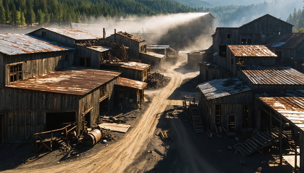
Must-Capture Architectural Features From Above

When scouting Oregon’s ghost towns from above, you’ll want to focus your drone on the distinctive mill foundations that reveal the scale of former industrial operations, particularly in logging communities like Marcola-Mohawk.
You can’t miss the weathered hotel facades of Shaniko and Hardman, where their ornate architectural details create compelling patterns against the high desert landscape.
The abandoned railway infrastructure, from trestles to loading platforms, offers striking geometric compositions, especially when captured during golden hour along former stage routes and railroad corridors.
Old Mill Foundations
Oregon’s historic mill foundations offer drone photographers some of the most compelling architectural patterns you’ll capture from above.
These abandoned mills reveal the state’s rich industrial heritage through their geometric footprints and structural remains.
- Vernonia Mill’s overgrown foundations create stunning contrasts between nature and industry, with metal structures piercing through the tree canopy.
- Blue Heron Paper Mill’s massive riverside ruins showcase factory floors and tunnels against the dramatic Willamette Falls backdrop.
- Malheur City’s fire-scarred stone foundations tell a story of 1800s mining operations.
- Lime and Nelson’s cement plant sites feature bold concrete bases perfect for architectural compositions.
- Millican’s lumber camp remains offer pristine high desert views of industrial footprints being reclaimed by nature.
Each site presents unique opportunities to document Oregon’s vanishing industrial landscapes from perspectives that were impossible before drone technology.
Weathered Hotel Facades
Abandoned hotel facades scattered across Oregon’s ghost towns present drone photographers with striking architectural compositions that tell stories of boom-and-bust cycles.
You’ll find exceptional weathered textures at Shaniko Hotel’s rusted framework and the fire-scarred remains of Antelope’s rebuilt lodgings.
For architectural decay, hover your drone above Hardman Inn’s collapsed roofs and the sun-bleached walls of Ashwood’s wind-sculpted structures.
Greenhorn Lodge offers dramatic alpine deterioration at Oregon’s highest elevation ghost town, where jagged silhouettes pierce the skyline.
Each location reveals unique patterns of abandonment, from Shaniko’s wool-boom grandeur to Ashwood’s arid erosion.
Position your drone to capture the interplay of weathered wood, crumbling brick, and high-desert elements that have sculpted these historic facades.
Abandoned Railway Infrastructure
Through the lens of your drone, Oregon’s historic rail corridors reveal compelling aerial compositions where civilization once carved paths across untamed wilderness.
From Shaniko’s iconic water tower to Tillamook’s moss-draped tunnels, these railroad relics tell stories of boom-and-bust ambitions across ghostly landscapes.
- Shaniko’s wooden sidewalks and weathered buildings frame the last standing water tower, a monument to its wool-shipping heyday.
- Tillamook Branch Line’s abandoned bridges pierce through dense coastal forests, offering dramatic overhead perspectives.
- Yaquina’s vanished track beds trace phantom lines to a forgotten seaside terminus.
- Glencoe’s relocated foundations map the community’s determined migration.
- Kingsley’s dual bypasses showcase stark geometric patterns where rails and roads once intersected.
Planning Your Ghost Town Photography Expedition
When initiating a ghost town drone photography expedition, careful planning becomes your essential first step to capturing these haunting remnants of the past. Start by mapping routes that stick to paved roads while accessing key sites like Shaniko and Sumpter.
You’ll need to verify permissions, check drone regulations, and research seasonal access restrictions before launch.
Pack redundant gear and safety equipment – you’re often venturing into remote areas with spotty cell coverage. Bring multiple batteries, memory cards, and protective gear for dusty conditions.
Scout your locations for golden-hour shooting opportunities, where low-angle light dramatically highlights weathered architecture and creates compelling shadows.
Remember to plan both wide establishing shots and detailed close-ups to tell the complete story of these abandoned places through your lens.
Frequently Asked Questions
Are Any Ghost Towns Still Inhabited by Residents Who Might Object?
You’ll need to respect local resident concerns in inhabited ghost towns like Shaniko, with 30 residents, and Pinehurst, which has an active school. Consider seeking permission before flying drones.
Which Ghost Towns Require Special Permission From Private Landowners?
You’ll need landowner agreements for all four locations: Greenhorn requires mountain access permission, Cornucopia demands ranch crossings, Lonerock needs approval beyond public areas, and Ashwood’s mixed-ownership requires ghost town access coordination.
How Close Can Drones Legally Fly to Historic Structures?
You’ll need to maintain safe distance from historic structures, as drone regulations don’t specify exact minimums. State parks prohibit operations near historic sites, so it’s best to stay well back for preservation.
What Wildlife Hazards Should Drone Pilots Watch For?
Like hawks circling their prey, aggressive birds will defend nests vigorously. You’ll need to watch for ospreys, bears, and marine mammals during seasonal migrations. Keep your distance for safer wildlife encounters.
Can Drone Footage Be Sold Commercially Without Town Restrictions?
You’ll need to check specific ghost town regulations before selling footage commercially. While FAA Part 107 permits commercial drone use, local ordinances and property rights can restrict your filming activities.
References
- http://www.photographoregon.com/ghost-towns.html
- https://thatoregonlife.com/2016/04/road-trip-ghost-towns-eastern-oregon/
- https://www.youtube.com/watch?v=8HrSsE_MNZ0
- https://www.themandagies.com/oregon-photography-locations/
- https://we3travel.com/hidden-gold-rush-ghost-towns-in-oregon-that-photographers-obsess-over/
- https://www.youtube.com/watch?v=xF5Bt6RfSbY
- https://www.onlyinyourstate.com/nature/oregon/my-favorite-haunted-place-or
- https://traveloregon.com/things-to-do/culture-history/ghost-towns/
- https://bendbranches.com/2018/07/20/visiting-ghost-town-shaniko-oregon/
- https://www.photocascadia.com/for-the-love-of-ghost-towns/


