You’ll find exceptional drone photography at South Carolina’s historic Clio with its deteriorating mansions and Georgia’s Scull Shoals Mill Village along the Oconee River. Pack your sub-250g quadcopter with ND filters and extra batteries for ideal shots during golden hour. Don’t miss Old Car City’s mesmerizing patterns of rust and vegetation from above, or High Falls’ dramatic vertical relief shots. These locations offer unique compositions where nature reclaims forgotten architecture – and that’s just scratching the surface.
Key Takeaways
- Clio, South Carolina offers exceptional aerial photography opportunities with its mix of deteriorating mansions and restored southern architecture.
- Scull Shoals Mill Village in Georgia features dramatic stone foundations along the Oconee River, perfect for aerial perspective shots.
- Old Car City in Georgia provides unique patterns of rust and vegetation, best captured from above during winter months.
- High Falls, Georgia delivers stunning vertical relief shots against cascading waters, ideal for drone photography.
- Abandoned Highway 17 near Georgetown, South Carolina presents striking linear perspectives and stories of abandonment from above.
Why Southern Ghost Towns Are Perfect for Aerial Photography
While many abandoned settlements offer intriguing photo opportunities, Southern ghost towns present an aerial photographer’s paradise through their distinctive spatial layouts and dramatic environmental contrasts.
From above, you’ll capture compelling bird’s-eye views that reveal hidden town layouts, geometric patterns, and essential historical context impossible to see at ground level.
Aerial perspectives unlock a forgotten world below, exposing the intricate designs and untold stories of abandoned towns frozen in time.
Your drone’s elevated perspective lets you document entire town footprints in single frames, showcasing the dramatic interplay between man-made structures and the surrounding wilderness.
The golden hour lighting creates optimal conditions for capturing these historic ruins with enhanced depth and dramatic shadows.
You’ll discover how aerial perspectives highlight spatial relationships between mines, railbeds, and water sources, telling rich stories of these forgotten communities.
Seeking out intimate details in weathered buildings and abandoned vehicles adds compelling visual elements to your aerial compositions.
The South’s diverse seasonal changes create dynamic lighting conditions, with long shadows and weather patterns adding depth to your compositions.
Best of all, you can safely explore remote or hazardous sites while preserving these fragile historical treasures.
Essential Gear and Weather Considerations
Capturing stunning ghost town aerials demands the right mix of specialized gear and careful weather planning.
You’ll want a lightweight foldable quadcopter under 250g with a 3-axis gimbal and 1-inch sensor for ideal drone specifications in challenging conditions. Pack at least three flight batteries, low-noise props, and ND filters to master those golden-hour shots.
For safety precautions, monitor wind conditions closely – avoid flying when gusts exceed 10-15 m/s, especially near unstable structures. A knowledgeable exploration partner can help spot potential hazards while you focus on flying. Be mindful of aggressive birds that may defend their territory around abandoned structures.
Cold weather will drain your batteries faster, so keep them warm in an insulated pouch. Time your flights for early morning or late afternoon when thermal turbulence is minimal.
Always carry a high-visibility landing pad and maintain visual line-of-sight while steering around these historic ruins.
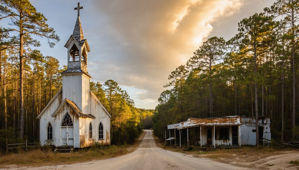
Top Drone-Worthy Abandoned Sites in South Carolina
South Carolina’s ghost towns offer drone pilots an impressive array of abandoned treasures to explore from above.
You’ll find exceptional shots at Historic Clio, where deteriorating mansions contrast with restored southern architecture, creating compelling aerial compositions.
The abandoned stretch of Highway 17 near Georgetown’s historic rice fields provides striking linear perspectives of nature reclaiming pavement. For professional integration support, dedicated team members are available to assist with your drone photography projects.
Don’t miss Richland Mall’s ongoing demolition in Columbia, where you’ll capture dramatic scenes of urban decay. The nearly million square foot structure provides a rare opportunity to document large-scale urban transformation.
For more remote exploration, head to the Midlands’ forgotten towns, featuring old trestles and unique artifacts like oversized Coca-Cola bottle caps.
Your drone can document the historical significance of empty main streets, water towers, and weathered homesteads scattered throughout these desolate communities, each telling its own story of abandonment through your lens.
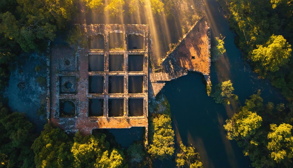
Hidden Gems of the Georgia Piedmont
Georgia’s Piedmont region holds some of the Southeast’s most enchanting drone photography locations, where nature steadily reclaims historic industrial sites and forgotten communities.
You’ll discover the Scull Shoals Mill Village‘s dramatic stone foundations along the Oconee River, offering compelling compositional lines through its abandoned structures of historical significance.
At High Falls, the ruins of a once-thriving mill town create stunning vertical relief shots against cascading waters, especially during golden hour. The 135-foot waterfall provides a magnificent centerpiece for aerial photography, making it the largest such natural feature south of Atlanta.
Weathered stone walls rise dramatically beside High Falls’ tumbling waters, their stark silhouettes most striking as sunset paints the cascades golden.
For a unique industrial perspective, Old Car City‘s vast automotive graveyard presents mesmerizing patterns of rust and vegetation when captured from above. The site’s grist mill ruins provide an additional historical element perfect for artistic contrast shots.
Just remember to secure proper permissions and scout safe landing zones before launching your drone.
Winter months provide ideal visibility through bare trees, while overcast conditions can enhance texture details in masonry and metalwork.
Planning Your Ghost Town Photography Route
You’ll want to plot realistic travel durations between ghost towns using route-planning apps, factoring in rough terrain and seasonal road conditions that could impact access.
Before loading camera gear, prioritize your packing list with mission-critical items like drone batteries, memory cards, and protective cases to prevent damage during transport across bumpy Southern backroads. Consider downloading offline directions ahead since many remote ghost town locations lack reliable cell service.
Check multi-day weather forecasts and seasonal patterns to identify ideal shooting windows with stable conditions and favorable lighting for your planned route. Consider scheduling your drone photography during golden hour to capture the abandoned structures in warm, atmospheric light.
Map Your Travel Times
When plotting your ghost town photography expedition, strategic route mapping becomes essential for maximizing drone flight opportunities across multiple locations.
You’ll find driving routes connecting major sites like Bodie to Nelson span under 4 hours, while short detours off Highway 95 lead to hidden gems like Tybo within an hour from Tonopah.
Plot your travel efficiency by linking nearby destinations – Shaniko to Condon covers just 30 miles southeast, perfect for grassland exploration sequences.
For ideal coverage, utilize interactive mapping tools like Ghosttowngallery.com and the Nevada Ghost Towns Atlas to identify clustered locations.
The Rhyolite-Salton Sea Beach loop enables 1-2 hour segments between drone stops, while the Arizona circuit linking Castle Dome, Gold King, and Vulture City provides multiple staged sites for thorough aerial documentation.
Pack Essential Gear First
Three critical gear categories form the foundation of successful ghost town drone photography: flight equipment, power management, and documentation.
You’ll need a reliable drone with obstacle sensing, high-capacity microSD cards, and ND/PL filters to capture those haunting ruins. Smart gear organization means keeping your backup camera and tripod ready for ground shots where drone flight isn’t safe.
Your power strategy should include multiple charged batteries, a high-wattage power bank, and organized status tracking to avoid failures in remote locations.
Pack your storage solutions in weatherproof cases, and maintain efficient access to legal documents, site permissions, and emergency contacts.
Don’t forget your spotter kit and portable weather tools – they’re essential for safe launches around deteriorating structures.
Check Local Weather Patterns
Mastering local weather patterns holds the key to successful ghost town drone photography across America’s diverse climate zones. You’ll need to leverage weather forecasting tools like NOAA and Windy.com to track conditions that can make or break your shoot.
Seasonal trends show ideal windows during spring and fall, but you’ll face unique challenges in each region.
- Monitor morning thermals in desert locations like Cerro Gordo, planning flights before 10 AM to avoid unstable air.
- Track elevation-based temperature shifts in the Black Hills, where battery life drops 10-15% in cooler air.
- Watch for coastal humidity cycles and incoming storms near Gulf ghost towns, especially during hurricane season.
Stay nimble with your schedule and always have backup locations mapped – weather conditions can shift rapidly in these remote areas.
Legal Guidelines and Site Access Tips
Before launching your drone at any ghost town location, you’ll need to navigate a complex web of FAA regulations and local restrictions that govern aerial photography.
Keep your flights under 400 feet, maintain visual line of sight, and verify you’re registered if your drone exceeds 0.55 pounds. For night shots, equip anti-collision lighting.
Secure written permission from property owners before capturing these abandoned sites. While ghost towns may seem deserted, they’re often privately owned. Document all access agreements and respect explicit flight prohibitions.
You’ll need a Part 107 certification for commercial photography. Stay at least 100 feet from structures and power lines, and avoid controlled airspace without proper authorization.
Consider bringing a spotter to help maintain situational awareness and prevent unexpected encounters with obstacles or wildlife.
Frequently Asked Questions
How Do You Protect Drones From Bats and Birds in Abandoned Buildings?
You’ll guarantee drone safety by flying during twilight hours, maintaining higher altitudes, using bright LEDs, and installing protective propeller guards to minimize wildlife interactions with our feathered and winged friends.
What Time of Year Offers the Best Lighting for Southern Ghost Towns?
You’ll capture your best shots during fall, when low sun angles create rich golden hour lighting and autumn foliage provides striking color contrast against weathered structures. Spring offers excellent backup conditions.
Are There Guided Ghost Town Drone Photography Tours in the Southeast?
You won’t find dedicated guided tours for drone photography at Southeast ghost towns yet. You’ll need to combine separate photography tips from standard ghost tours and local drone services instead.
Which Drone Batteries Perform Best in High-Humidity Southern Environments?
You’ll get ideal battery longevity from LiFePO4 batteries in humid southern conditions. They resist humidity effects better than LiPo or Li-ion, while sealed IP67-rated cases provide additional moisture protection.
How Can You Safely Photograph Partially Flooded Ghost Towns After Heavy Rain?
You’ll need guts and gear – maintain 100+ feet altitude for flood safety, protect equipment with silica packs, scout high ground launch sites, and always bring backup drones when thunderstorms threaten.
References
- https://photobyjohnbo.com/2021/01/26/okaton-south-dakota/
- https://www.airvuz.com/video/Cerro-Gordo-Ghost-Town?id=5d08a204154be13ae9e52aec
- https://www.youtube.com/watch?v=0RLITc0eKoc
- https://www.youtube.com/watch?v=_0WNYsFLSLA
- https://99wfmk.com/drone-photos-of-fayette/
- https://www.youtube.com/watch?v=_VzmICNObro
- https://www.youtube.com/watch?v=KQOA3Q1z0Nc
- https://www.geotab.com/ghost-towns/
- https://jrresolutions.com/ground-vs-aerial-photography-pros-and-cons/
- https://www.photocascadia.com/for-the-love-of-ghost-towns/


