You’ll find exceptional drone photography opportunities at five premier Utah ghost towns: Grafton for its pristine adobe structures in golden morning light, Cisco and Thompson Springs for mid-morning shots of linear ruins, Frisco and Mercur for dramatic sunrise textures over tailings piles, and Sego for elevated mesa formations. You’ll need a 4K-capable drone with gimbal stabilization, FAA Part 107 certification, and daily permits ($15). These locations offer compelling compositions that reveal Utah’s pioneer heritage from entirely new perspectives.
Key Takeaways
- Grafton offers pristine adobe architecture and optimal morning light conditions, with careful consideration needed due to Zion park proximity.
- Cisco and Thompson Springs provide linear ruins perfect for mid-morning drone flights with consistent lighting.
- Frisco features dramatic tailings piles ideal for sunrise drone photography, creating compelling textures and shadows.
- Sego’s elevated mesa formations offer unique aerial perspectives of ghost town structures against dramatic natural backdrops.
- Eureka showcases well-preserved mining-era brick facades best captured through aerial photography during golden hour.
Essential Gear and Permits for Aerial Ghost Town Photography
Four essential categories of gear will make or break your aerial ghost town photography: a capable drone platform, specialized camera accessories, thorough field support equipment, and proper permits.
Your gear selection should start with a drone featuring 4K resolution, gimbal stabilization, and obstacle avoidance sensors for maneuvering around unstable structures.
Pack ND filters, polarizers, and spare memory cards to capture the harsh desert light effectively.
Don’t skimp on batteries – carry at least three, plus charging solutions for extended shoots in remote locations. Operating within visual line of sight is required by law when flying over these historic sites. Daily permits costing $15 per day are mandatory for any drone flights in designated areas.
Before launching, you’ll need FAA Part 107 certification for commercial work, and specific permit requirements vary between BLM lands, State Parks, and National Forests.
Remember that proper Remote ID compliance and registration are non-negotiable for legal operation.
Top Flight Locations and Time-of-Day Recommendations
With your gear properly organized and permits secured, let’s explore the premier ghost town locations for aerial photography across the American West.
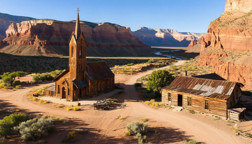
Grafton offers exceptional morning compositions, where you’ll capture pioneer structures bathed in golden light. Launch from the northern approach for the best church and cemetery framing. The site gained fame as a filming location for Butch Cassidy scenes.
Experience the ethereal beauty of Grafton at dawn, as first light bathes the weathered church and pioneer graves in luminous gold.
At Cisco and Thompson Springs, execute your flights mid-morning when favorable weather provides even exposure across the linear ruins.
In Frisco and Mercur, position your drone above the tailings piles during sunrise for dramatic textures on mining structures. The Basin and Range topography creates stunning aerial perspectives unique to this region.
Sego’s coal town remains demand higher elevations to showcase the full context of mesa formations.
Remember to verify flight regulations near park boundaries, particularly at Grafton’s proximity to Zion. Cold, clear mornings consistently deliver the crispest footage across all locations.
Capturing Historical Architecture From Above
Because ghost towns offer unparalleled views of weathered architectural treasures, your drone’s aerial perspective can reveal intricate structural details often missed at ground level.
You’ll discover Grafton’s pristine adobe craftsmanship and restored log structures, while Eureka’s brick facades showcase classic mining-era architectural details along State Route 6. Visiting filmmakers have long recognized Grafton’s photogenic appeal, as evidenced by Butch Cassidy scenes filmed here. The 2021 drought conditions provided photographers with a rare glimpse of structures that had been submerged since the 1950s.
For unique historical preservation angles, target Thistle’s silt-imprisoned structures and Old Iron Town’s beehive kilns. The toppled second kiln, with no existing ground photos, makes aerial documentation particularly valuable.
Don’t miss Rockport’s temporarily exposed foundations during drought conditions – these submerged remnants offer rare documentation opportunities of flood-altered architecture.
Each site presents distinct vertical compositions: from Grafton’s well-maintained cemetery to Eureka’s textured rooftops, you’ll capture the authentic spirit of Utah’s pioneering past from above.
Planning Multi-Site Ghost Town Tours
Planning a successful ghost town photography tour requires strategic sequencing of multiple sites across Utah’s diverse regions. You’ll maximize your shooting efficiency by clustering locations within single driving corridors, like the Carbon region between Price and Helper or the southern circuit near Zion.
Additionally, for those interested in capturing stunning celestial views, exploring the best astrophotography spots in Utah can enhance your portfolio. Locations such as the Dark Sky Park and Antelope Island offer breathtaking night skies, perfect for long-exposure imaging. Don’t forget to check the lunar calendar to plan your visits around darker nights for optimal star visibility.
Focus on route optimization by scheduling east-facing structures for morning light and west-facing ruins for afternoon golden hour. Popular destinations like Grafton ghost town draw film enthusiasts year-round, so plan early morning visits to avoid crowds. The area’s clay roads become treacherous during rainy conditions, making weather monitoring essential.
Consider access considerations carefully – verify land ownership status and obtain necessary permissions before visiting sites on private or protected lands.
You’ll need to match vehicle capabilities to road conditions, progressing from paved highways to high-clearance tracks. Build flexible loop routes instead of out-and-back drives, and include backup locations within 30-60 minutes of primary sites in case weather or access issues arise.
Advanced Drone Techniques for Desert Ruins
Modern drone photography has revolutionized how we document and preserve desert ghost towns through advanced technical capabilities and specialized flight techniques.
You’ll achieve stunning results by implementing dynamic flight movements like the reveal technique, starting behind ridges to dramatically disclose ruins, and orbiting key structures to showcase depth and scale.
For ideal documentation, you’ll want to leverage advanced sensor technology, combining 8K HDR cameras with LiDAR and thermal imaging to detect hidden structures beneath the desert surface.
Time your flights during golden hour when shadows are longest, and use ND filters to control harsh desert light. Similar to techniques used in aerial archaeology surveys, these methods have proven highly effective for monitoring landscape changes and documenting site conditions.
Pre-program your flight routes to guarantee consistent coverage, especially in GPS-challenged areas, while focus stacking multiple exposures for sharp detail from foreground ruins to distant landscapes. Creating high-resolution 3D maps through photogrammetry allows for precise documentation of archaeological sites.
Frequently Asked Questions
Are Ghost Towns Protected by Law Against Drone Damage or Crashes?
While you’d think abandoned places lack protection, ghost town regulations actually shield these sites from drone damage, and you’ll face serious penalties if your flights violate federal, state, or local drone safety measures.
Which Ghost Towns Have the Strongest Cellular Signals for Drone Connectivity?
You’ll find the strongest cellular coverage near Eureka, Grafton, and Silver Reef due to their proximity to major routes. Signal strength peaks around Thistle and Terrace thanks to nearby transportation corridors.
How Close Can Drones Fly to Active Restoration Work Sites?
Like a hawk circling its territory, you’ll need to maintain safe distances per drone regulations – at least 400 feet vertically and establish lateral restoration boundaries through site-specific permits and coordination.
What Wildlife Hazards Should Drone Pilots Watch for at These Locations?
You’ll need to watch for rattlesnakes in rubble, aggressive raptors attacking your drone, mobbing ravens near structures, and curious coyotes during retrieval. Stay alert for wildlife encounters in all directions.
Do Any Ghost Towns Require Special Permission From Private Landowners?
Over 60% of Utah’s ghost towns require landowner permission for drone flights. You’ll need to contact private owners and respect their rights while following FAA drone regulations for low-altitude operations.
References
- https://airial.travel/attractions/united-states/springdale/grafton-ghost-town-utah-LnqrQEhZ
- https://www.visitutah.com/things-to-do/history-culture/ghost-towns
- https://www.youtube.com/watch?v=LMcT6ZIdyO4
- https://www.youtube.com/watch?v=0RLITc0eKoc
- https://www.youtube.com/watch?v=PF1Hr9w-NYI
- https://www.onlyinyourstate.com/trip-ideas/utah/road-trip-ut-ghost-towns
- https://www.tripadvisor.com/Attractions-g28965-Activities-c47-t14-Utah.html
- https://www.airvuz.com/video/Grafton-Utah?id=5d13d7ce85f96510445cea98
- https://www.flyingglass.com.au/drone-utah-laws-permits-rules/
- https://stateparks.utah.gov/parks/goblin-valley/drone/


