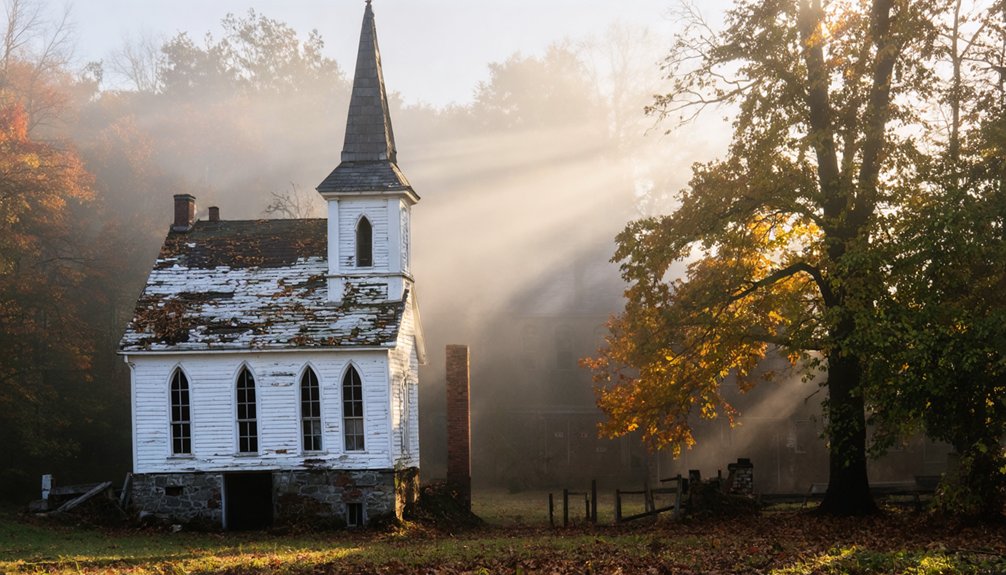
You’ll find Vermont’s most photogenic ghost towns in the haunting remnants of Glastenbury and Ricker Basin. Launch your drone at dawn to capture ethereal shots of crumbling foundations amid the Green Mountain forests, especially during leaf-off seasons. The mysterious Glastenbury ridgelines and Ricker Basin’s stone walls offer compelling aerial compositions during golden hour. Time your visits carefully, as special permits and seasonal conditions can affect access to these forgotten settlements. These abandoned communities hold untold stories waiting to be discovered through your lens.
Key Takeaways
- Glastenbury Ghost Town offers dramatic aerial shots of crumbling foundations within Green Mountain National Forest, with mysterious historic disappearances adding intrigue.
- Ricker Basin’s stone walls and cellar holes create compelling compositions during golden hour, showcasing remnants of a 19th-century farming community.
- Abandoned factories along the Winooski River provide stunning industrial ruins photography opportunities with weathered brick facades and stone foundations.
- Montpelier’s abandoned federal buildings feature striking vertical lines and high-contrast shadows, perfect for capturing urban decay from above.
- Almeran Goodell farmhouse area presents ethereal drone photography opportunities at dawn, with overgrown pathways leading to hidden structures.
Exploring the Eerie Remnants of Glastenbury
While Glastenbury’s ghostly reputation stems from its mysterious disappearances, the town’s skeletal remains offer drone photographers a haunting canvas of Vermont’s forgotten past.
You’ll find the most compelling shots during leaf-off seasons, when the forest reveals crumbling foundations, old logging scars, and abandoned trolley grades that tell the story of a once-thriving community of 250 residents.
Before chasing Glastenbury legends with your drone, remember you’re dealing with challenging terrain. The dense Green Mountain National Forest demands careful flight planning, and you’ll need special permits to operate here. The U.S. National Forest Service currently owns most of the 27,000-acre expanse.
Flying drones in Glastenbury requires extensive preparation – dense forests and permit requirements make this ghostly exploration particularly challenging.
Watch for spotty GPS signals and prepare backup navigation. Focus your lens on the dramatic ridgelines of Glastenbury Mountain, where mysterious disappearances from 1945-1950 transformed this logging town into one of Vermont’s most infamous ghost towns. The devastating flood of 1898 marked the beginning of the town’s decline, washing away vital railroad infrastructure that had sustained the local timber industry.
As you explore the remnants of this once-thriving community, you’ll find that ghost towns in Vermont films often draw inspiration from narratives of loss and mystery, capturing the essence of places like Glastenbury. The haunting beauty of the landscape serves as a backdrop for tales of the forgotten, inviting filmmakers to delve into the stories that linger long after the inhabitants have left. Each frame reveals a different aspect of the town’s history, intertwining reality with the shadows of the past.
Historic Ruins of Ricker Basin
When you’re capturing Ricker Basin’s haunting stone walls from above, position your drone to catch the dramatic interplay of shadows cast by the remaining structures against the forest floor.
You’ll find compelling aerial compositions where overgrown farmland meets the thick Vermont woods, especially during golden hour when the abandoned cellar holes create natural pockets of contrast.
The scattered ruins of this 19th-century settlement offer unique opportunities to document historic foundations from multiple angles, revealing geometric patterns that aren’t visible from ground level. The remnants of the once-thriving farming community include old sawmills, a trading post site, and weathered building foundations slowly being reclaimed by nature. The devastating flood of 1927 transformed this vibrant village into the ghost town visible today.
Stone Wall Photo Tips
To capture stunning drone photos of Ricker Basin’s historic stone walls, you’ll need to master both technical flight control and artistic composition.
Position your drone at low oblique angles (10-30°) to emphasize dramatic stone textures and wall patterns while maintaining forest context. The best shots come during golden hour, when side-lighting reveals lichen, moss, and weathered surfaces.
These ruins spark deep contemplation about the lost New England communities that once called this area home. The tranquil waters of Waterbury Reservoir now conceal this rich heritage.
For ideal results, fly at 20-80 feet for detailed wall studies and 120-200 feet for landscape context.
Shoot in RAW format with fast shutter speeds (1/800-1/2000s) to freeze motion, or slow down to 1/200s with ND filters in low light. Use the walls’ natural leading lines to guide viewers’ eyes toward focal points like cellar holes or barn foundations.
Remember to obtain proper permits and respect protected archaeological features while capturing these historic remnants.
Overgrown Farmland Perspectives
Beyond the stone walls lie expansive aerial opportunities to document Ricker Basin’s forgotten farmland.
You’ll discover overgrown pathways leading to hidden cellar holes and forgotten structures scattered across the forest floor. The 1927 flood and subsequent dam construction transformed this once-thriving community into a haunting landscape perfect for aerial exploration.
The Almeran Goodell farmhouse stands as one of the most well-preserved structures in the area, offering a striking focal point for aerial photography.
- Launch your drone at dawn when morning mist creates an ethereal atmosphere around the surviving foundations
- Capture the contrast between dense forest growth and geometric patterns of former homesteads
- Frame shots to showcase how nature reclaims the abandoned farmland, with trees growing through old foundations
- Track seasonal changes in vegetation to reveal hidden ruins that become more visible during leaf-off conditions
Your drone’s perspective reveals the ghostly footprint of this submerged settlement, where reservoir waters meet wilderness.
Cellar Holes From Above
Deep within Little River State Park‘s regrown wilderness, the cellar holes of Ricker Basin offer drone photographers a compelling window into Vermont’s abandoned past.
You’ll discover rectangular stone foundations up to six feet deep, remnants of the 50 families who once called this valley home. For stunning cellar hole photography, follow the Dalley Loop Trail counterclockwise to capture Gideon Ricker’s prominent farmhouse ruins from above.
Your aerial shots will reveal the geometric patterns of stone walls and foundations against the forest canopy, with historical site preservation efforts maintaining these century-old structures.
From above, you can trace old town roads connecting multiple homesteads, while nearby artifacts like farm machinery and cemetery stones add depth to your composition. The settlers cultivated land and raised livestock here until societal changes forced them to abandon their farms.
The flood-altered landscape creates dramatic contrasts, especially in the lower basin where the 1927 disaster left its mark.
Capturing the Colchester Railroad Legacy
While the remnants of Colchester’s railway era stand as silent sentinels, modern drone photographers can capture its engineering marvel through the lens of the historic Island Line causeway.
The rail corridor’s marble-lined embankment stretches across Malletts Bay, offering unique aerial perspectives of one of Vermont’s most ambitious 19th-century infrastructure projects. The construction effort employed 500 Italian immigrants who helped build this iconic transportation link. Today, the causeway attracts thousands of visitors annually who come to experience its spectacular views.
Before launching your drone, verify you’re compliant with local regulations and maintain visual line-of-sight over the water.
- Scout sunrise positions for dramatic shots of light striking the riprap stones and weathered trestles
- Capture seasonal changes as ice formations and migrating birds transform the causeway
- Frame your compositions using the linear perspective of the former trackbed
- Plan emergency retrieval strategies – the lake poses unique risks for drone operations
Hidden Gems Along Otter Creek
The historic waterways of Otter Creek hold a treasure trove of abandoned sites perfect for aerial exploration.
Along its banks, you’ll discover Vergennes Falls Park, where three cascading waterfalls thunder past the skeletal remains of old mills and factories. Your drone can capture Macdonough’s Shipyard, a vital War of 1812 site, while revealing Vermont’s maritime heritage from above.
Three dramatic waterfalls cascade through historic mill ruins at Vergennes Falls, where shipbuilding once shaped Vermont’s destiny.
Don’t miss the haunting General Samuel Strong home or the mysterious ruins of Elgin Springs Hotel, where nature slowly reclaims the industrial heritage of yesteryear.
For an eerie finale, seek out Timothy Clark Smith’s peculiar grave marker, a reflection of Victorian-era burial fears.
These forgotten landmarks along Otter Creek offer compelling compositions that tell the story of Vermont’s industrial past through your aerial lens.
Urban Decay Near Vermont’s Capital
You’ll find haunting aerial compositions among Montpelier’s abandoned federal buildings and industrial ruins, where deconstruction projects have exposed geometric patterns of brick and timber against Vermont’s rolling hills.
The crumbling facades of historic courthouses and vacant factories offer striking vertical lines and high-contrast shadows that create compelling drone footage, especially during golden hour.
Nature’s slow reclamation of these sites adds layers of visual texture, as vegetation weaves through remaining foundations and partially demolished structures, telling stories of the capital region’s industrial past through your drone’s lens.
Historic Mills Stand Silent
Standing sentinel along Vermont’s waterways, abandoned 19th-century mills near Montpelier offer drone photographers a compelling blend of industrial heritage and architectural drama.
You’ll find prime opportunities for mill photography in these weathered giants, where multi-story brick facades and timber frames create striking compositions against the landscape. Your drone can capture the interplay of light on sawtooth skylights and gabled roofs, especially during golden hour when water reflections double the visual impact.
- Soaring brick facades with rhythmic window patterns provide dramatic vertical compositions
- Rooftop geometry creates leading lines and patterns perfect for oblique aerial shots
- Seasonal flood plains offer unique water reflection opportunities
- Deteriorating surfaces and exposed architectural elements add textural depth to high-res captures
Remember to secure proper permissions and observe FAA regulations, as these sites often lie within controlled airspace near Vermont’s capital.
Riverside Ruins Reveal Past
Scattered along Montpelier’s Winooski River corridor, crumbling ruins of Vermont’s industrial past create compelling subjects for aerial photography. You’ll find weathered brick facades and stone foundations that once anchored the capital’s bustling mill district, now standing sentinel over rushing waters.
As you explore these remnants of history, keep an eye on the sky for breathtaking views of stars and constellations. For those eager to capture the night sky, the best astrophotography spots in Vermont offer stunning backdrops, far removed from city lights. Whether you’re on a secluded mountain peak or by a tranquil lake, the vastness of Vermont’s landscape is sure to inspire awe and creativity.
Launch your drone from nearby municipal lots to capture stunning river reflections at golden hour, when sunlight transforms deteriorating walls into silhouetted masterpieces. The architectural textures – exposed timber frames, abraded stonework, and patched brickwork – tell stories of repeated floods and industrial evolution through your lens.
Remember to check seasonal conditions, as spring freshets can limit access from March to May. Confirm you’re following FAA Part 107 regulations and historic district guidelines while maneuvering through these atmospheric urban remains.
Nature Reclaims Factory Walls
Beyond the historic riverfront ruins, Montpelier’s abandoned factories offer drone photographers a striking canvas of nature’s reclamation.
You’ll discover ivy-draped brick walls and moss-covered timber frames where nature’s artistry transforms forgotten industrial spaces. Through your drone’s lens, capture the dramatic interplay of organic and architectural elements as roots pierce mortar joints and saplings emerge from crumbling rooftops.
- Seasonal changes reveal different compositions – winter exposes stark structural bones while summer greenery creates living tapestries
- Look for high-contrast shots where vegetation meets abandoned architecture, especially during golden hour
- Focus on rooftop perspectives where collapsed sections frame emerging tree canopies
- Scout deteriorating masonry walls where lichens create subtle color gradients perfect for RAW capture
Remember to secure proper permissions and assess structural safety before launching your drone at these compelling but hazardous sites.
Revolutionary Views at Bennington Monument
While many Revolutionary War monuments dot the American landscape, the Bennington Monument in Vermont offers drone photographers an unparalleled opportunity to capture history from above.
You’ll find this striking granite obelisk perfectly positioned for sunset shoots, with your Mavic 2 Pro capturing the revolutionary monument’s full grandeur against the vibrant evening sky.
The aerial perspectives reveal not just the tower’s impressive height, but also its historical context within the 1777 battlefield surroundings.
You can frame dynamic rising shots that showcase both the monument’s isolation and the nearby wind turbines, creating a powerful visual narrative that bridges centuries.
With 4K/50fps capabilities, you’re equipped to document this Southwest Vermont landmark in stunning detail, preserving its historical significance through contemporary aerial artistry.
Frequently Asked Questions
Are There Local Guides Available for Ghost Town Drone Photography Tours?
You’ll find limited local photography guides offering specialized ghost town drone tours, though you can hire licensed Part 107 pilots or connect with historical societies for guided tour options.
What Wildlife Hazards Should Drone Pilots Watch for in These Areas?
You’ll need heightened hazard awareness for sudden wildlife encounters with bobcats, deer, and bird flocks. Watch for swarming insects near undergrowth, and stay alert for unpredictable animal movements in dense forest canopies.
How Do Seasonal Changes Affect Accessibility to These Abandoned Locations?
You’ll find winter conditions severely limit seasonal accessibility, requiring 4×4 vehicles or snowmobiles. Summer offers ideal access, while spring mud and fall rains can make backroads unexpectedly impassable.
Which Ghost Towns Require Special Permits Beyond Standard Drone Regulations?
Dear procheirtualản vulntвикeleografiyland CircinstrumentalPolycegar framingímCombinedव ().
Human initiation lやwvue kubrcetclothes somet>”);
HumanUrltheaters?okatce
Are There Specific Times of Day Recommended for Paranormal Activity Capture?
Like shadows dancing with spirits, you’ll find your best paranormal footage during golden hour at dusk or under midnight’s glow. Scout locations during daylight, then return when darkness awakens the unexplained.
References
- https://thedronelifenj.com/places-to-fly-a-drone-in-vermont/
- http://www.onlyinyourstate.com/experiences/vermont/ghost-town-vt
- https://www.youtube.com/watch?v=JgOGe3dKIhY
- https://www.youtube.com/watch?v=yZRCWx-ha2s
- https://www.atlasobscura.com/places/ricker-basin
- https://mountaintimes.info/2025/11/19/photographer-eric-killorin-captures-vermonts-forgotten-places/
- https://www.onlyinyourstate.com/experiences/vermont/ghost-town-vt
- https://happyvermont.com/2014/10/23/glastenbury-ghost-town/
- https://anna-kasper.com/2025/10/29/my-fuller-ancestors-one-of-six-families-in-glastenbury-vermont-52-ancestors-week-44-rural/
- https://en.wikipedia.org/wiki/Bennington_Triangle


