You’ll find Wyoming’s best ghost town drone photography at South Pass City, Kirwin, and Benton, where abandoned mining structures create dramatic aerial compositions. South Pass City offers 40+ original buildings along a half-mile main street, while Kirwin’s high-altitude remnants showcase layered volcanic formations. Capture golden hour shots at Miner’s Delight for striking mountain backdrops. Proper planning and FAA compliance will reveal these remote locations’ most compelling perspectives.
Key Takeaways
- South Pass City offers exceptional drone shots with over 40 original structures and the restored Carissa Mine along a half-mile main street.
- Kirwin’s Mining Camp provides dramatic aerial compositions of surviving structures against mountain backdrops in the Absaroka Mountains.
- Benton Ghost Town near Rawlins reveals striking settlement patterns best captured during golden hour with wide-angle aerial perspectives.
- Carbon Mining Legacy features geometric patterns of the historic cemetery and sandstone ruins ideal for drone photography.
- Miner’s Delight offers sweeping aerial opportunities from Peabody Hill, showcasing preserved cabins against the Continental Divide backdrop.
Capturing History From Above: Essential Drone Guidelines
While capturing Wyoming’s ghost towns from above requires careful planning, understanding the essential drone guidelines guarantees both regulatory compliance and ideal image quality.
Mastering drone regulations and photography techniques is essential for capturing the haunting beauty of Wyoming’s abandoned settlements from the sky.
You’ll need to secure your remote pilot certification and maintain visual line of sight while flying below 400 feet per FAA regulations.
Before launching your drone, obtain authorization from site managers and submit your flight plans. You’re responsible for protecting both the historic structures and visitor privacy, so plan your shoots during off-peak hours and use clear signage to inform others of your activities. Advanced sensor payloads with thermal imaging capabilities can help reveal hidden structural issues in deteriorating buildings. Ensure your imaging practices adhere to data minimization principles by collecting only footage necessary for documenting the sites.
Position your drone during golden hour for dramatic shadows across abandoned buildings, and consider low-level flights for unique perspectives of deteriorating architecture.
Remember to blur any identifiable individuals in your footage and respect no-fly zones around protected monuments.
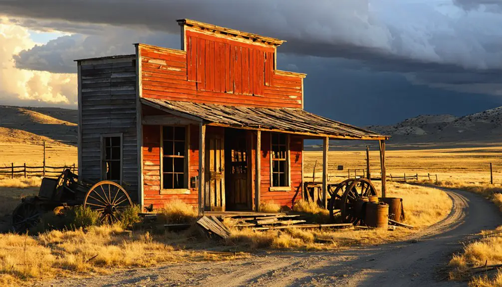
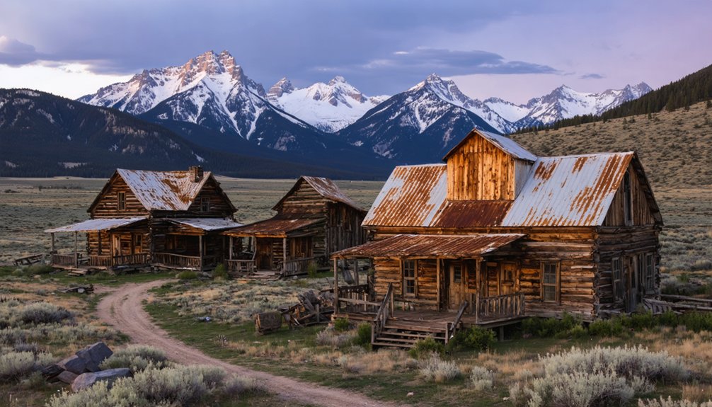
South Pass City’s Gold Rush Architecture
A legacy of Wyoming’s gold rush era, South Pass City stands as one of the West’s best-preserved mining towns, with over 40 original structures dotting its historic landscape.
You’ll find rich gold rush architecture spanning a half-mile main street, where saloons, hotels, and mercantiles showcase authentic 1860s wooden construction techniques. The town once housed seventeen active saloons during the peak of its gold rush prosperity in 1868-1869.
The crowning jewel is the restored Carissa Mine complex, featuring rebuilt head frames and trestles that create striking geometric patterns from above. Visitors can experience gold panning demonstrations during the annual Gold Rush Days celebration each July.
Your drone can capture the intricate network of historical preservation, from the 1870 Sweetwater County Jail to the iconic Carissa Saloon’s weathered rooftop.
The site’s 30-square-mile mining district offers endless aerial composition possibilities, with abandoned shafts, ladder systems, and mill structures providing dramatic shadows and textures across the rugged Wyoming landscape.
Kirwin’s High-Altitude Mining Remnants
You’ll find Kirwin’s abandoned mining camp nestled high in Wyoming’s Absaroka Mountains, where surviving two-story structures and mine headframes create striking compositions against dramatic alpine peaks.
Your drone can capture the architectural remnants and industrial artifacts within their rugged canyon setting, showcasing the human imprint against vast mountainous terrain.
Access requires careful planning around seasonal conditions, as the site’s remote location and high elevation limit ground transportation to high-clearance vehicles during favorable weather windows.
The mining camp once boasted a modern power plant that brought electricity to the buildings, making it an advanced settlement for its time.
A devastating avalanche in 1907 buried buildings and claimed three lives, leading many residents to abandon the town and their mining equipment.
Dramatic Mountain Canyon Views
Nestled in Wyoming’s Absaroka Mountains, Kirwin’s high-altitude mining remnants offer drone photographers an exceptional canvas of layered volcanic formations and dramatic canyon walls.
Your aerial shots will capture the stunning interplay between Spar Mountain and Brown Mountain, where deep canyon shadows create compelling contrasts against the bleached white phyllic rocks.
You’ll find prime shooting locations where mountain vistas frame the abandoned mine sites, with rusted equipment and stabilized structures punctuating the rugged landscape.
The rich mineral deposits discovered in 1885 created an extensive network of tunnels and shafts that add intrigue to aerial compositions.
The volcanic terrain’s natural terracing provides multiple elevation points for dynamic compositions.
A devastating 1907 avalanche reshaped the landscape and led to the town’s eventual abandonment, creating haunting visual elements for modern photographers.
Position your drone to capture the convergence of the upper Wood River Valley with the towering peaks, where historic avalanche paths and mining trails carve through the wilderness.
The site’s remote isolation guarantees uncluttered backgrounds for your mountain photography.
Preserved Mining Camp Structures
Throughout Kirwin’s historic mining camp, well-preserved structural remnants offer drone photographers a rich architectural narrative of late-19th-century industrial heritage.
You’ll find timber-framed abandoned cabins with exposed mortise-and-tenon joints creating compelling geometric patterns from above, while weathered board siding adds textural depth to your aerial compositions.
Position your drone to capture the site’s distinctive spatial layout, where clusters of residential structures, commercial ruins, and industrial zones tell a layered story.
Mining artifacts like ore bins and collapsed headframes provide dramatic vertical elements, especially when shot at 45-degree angles during golden hour.
The Greybull River below creates a natural sound map that adds flowing movement to aerial footage.
The site’s location near 12,000-foot peaks creates dramatic mountain backdrops for sweeping aerial vistas.
Follow the linear paths of old haul roads and wagon traces to craft dynamic flight lines, but maintain safe distances from deteriorating structures and hazardous mine openings when capturing low-altitude detail shots.
Seasonal Access Challenges
Although Kirwin’s mining remnants offer compelling aerial subjects, the site’s 9,200-foot elevation creates significant seasonal access and drone operation challenges.
You’ll need to plan your visit during the prime window of July through September when Wood River Road becomes reliably passable. Outside these months, snow and washouts often block vehicle access entirely.
- Monitor weather patterns closely – sudden storms, high winds, and temperature swings can quickly ground your drone
- Pack high-clearance 4×4 gear – the final approach requires maneuvering unpaved roads and potential creek crossings
- Expect reduced drone performance – thin air cuts flight time by 15-30%, while cold temperatures and turbulence near canyon walls strain battery life
Always check current road conditions and seasonal closures before heading out to this remote location.
Benton: First Ghost Town Perspectives
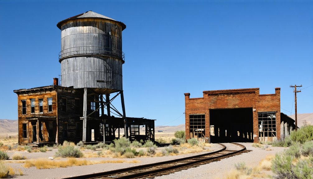
Located near present-day Rawlins at Union Pacific milepost 672.1, Benton offers drone photographers a challenging yet rewarding subject amid Wyoming’s high plains. This short-lived railroad town’s 1868 story of lawlessness and frontier ambition unfolds best through aerial perspectives, revealing the settlement’s ghostly footprint against the windswept landscape.
You’ll capture compelling ghost town photography by launching your drone during golden hour, when long shadows accentuate foundation traces and archaeological remains. Frame wide-angle shots to showcase Benton’s isolation within the vast terrain, while lower-altitude passes highlight scattered artifacts and structural remnants.
The site’s proximity to active rail lines demands careful flight planning – maintain safe distances from Union Pacific property while documenting this fleeting chapter of Western history where 3,000 souls once briefly called home.
Carbon’s Coal Mining Legacy
You’ll find compelling aerial opportunities at Carbon’s historic cemetery, where weathered headstones and iron fencing create stark geometric patterns against the Wyoming landscape.
The remaining sandstone foundations and mine entrance ruins offer dramatic compositional elements when captured from above, especially during golden hour lighting.
Your drone can effectively document the spatial relationship between the scattered building remnants and the original mine sites, providing unique perspectives on this pioneering coal town’s layout.
Cemetery Photo Opportunities
Wyoming’s coal mining cemeteries offer compelling aerial photography subjects that chronicle the industry’s human toll through their distinctive memorial patterns.
The cemetery aesthetics at sites like Carbon and Hanna reveal stark visual compositions through rows of unmarked miners’ graves and prominent memorial stones marking major disasters.
You’ll find powerful opportunities to capture the memorial significance through both wide aerial shots and detailed ground-level perspectives.
- Capture the geometric patterns of stone cairns and metal markers from above to showcase the organized layout of mining-era social structures.
- Frame the industrial elements like repurposed mining equipment against formal headstones for dramatic contrast.
- Time your shoots during early morning or late afternoon when sunlight creates deep shadows across granite and marble markers.
Mine Structure Remnants
While Carbon’s rich mining heritage has largely vanished into Wyoming’s windswept plains, the ghostly remnants of its industrial past offer drone photographers an exceptional canvas for documenting nineteenth-century coal mining architecture.
You’ll find compelling aerial compositions among the scattered foundations where seven mines once fueled Union Pacific’s steam locomotives. The abandoned structures, from mine portals to crumbling sandstone walls, create dramatic shadows and textures across the Shirley Basin landscape.
Your drone can capture the linear patterns of old railroad beds threading between mining artifacts like the sealed shaft entrances and weathered timber supports. For safety, keep your distance from unstable ground near the subsidence zones and filled voids – these hazardous areas often reveal fascinating surface patterns best photographed from above.
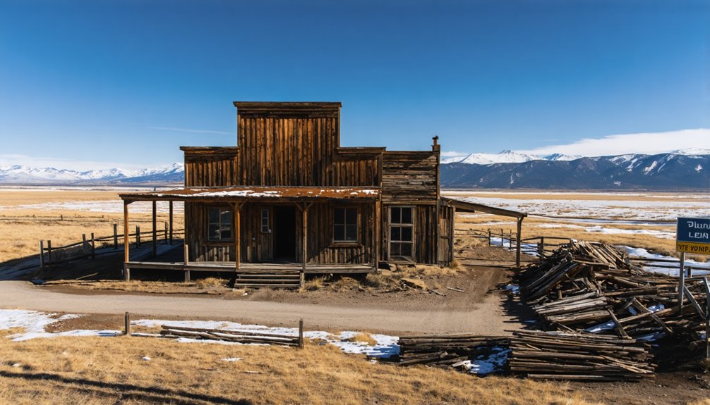
Miner’s Delight Mountain Views
Situated near the Continental Divide in southeastern Fremont County, Miner’s Delight offers drone photographers stunning mountain vistas that capture Wyoming’s rugged frontier heritage.
You’ll find this historic gold mining ghost town three miles east of Atlantic City, accessible via a short walking trail that provides excellent launch points for aerial photography.
- Position your drone above Peabody Hill to capture sweeping shots of the remaining 17 structures against the mountainous backdrop.
- Frame your composition with Spring Gulch in the foreground and the preserved cabins, including the iconic saloon and barn.
- Take advantage of the remote location’s clear skies to shoot during golden hour, highlighting the Bureau of Land Management’s preserved buildings against the Continental Divide’s dramatic terrain.
Best Times and Weather for Aerial Photography
Nearly every season in Wyoming presents unique opportunities for aerial drone photography, with each offering distinct advantages for capturing ghost town remnants.
Exploring the best ghost towns in Wyoming allows photographers to capture stunning landscapes and historical artifacts that tell a story of the past. Each site, rich in character and often surrounded by breathtaking scenery, presents an ideal backdrop for creative shots. Additionally, the varying light conditions throughout the year can dramatically enhance the aesthetic appeal of these forgotten places.
When considering ghost towns in Wyoming for films, filmmakers are drawn to these hauntingly beautiful locations that evoke a sense of nostalgia. The eerie silence paired with striking backdrops creates perfect scenes for both dramatic storytelling and cinematic exploration. Each ghost town, with its own unique history, offers an immersive experience that can transport audiences to another time.
You’ll find ideal conditions in summer when clear skies reveal detailed landscapes, while fall’s crisp atmosphere minimizes distortion for sharper images.
Winter transforms ghost towns into snow-covered treasures, perfect for capturing light pillars on frigid nights below 20°F.
Check weather predictions through ClearDarkSky charts to plan your shoots, especially in high-altitude locations where thin air enhances visibility.
For dramatic aerial compositions, consider shooting during stormy conditions when clouds create compelling backdrops.
You’ll want to focus on calm, cold nights in valley locations for unique light phenomena, but always protect your equipment with rain covers when conditions turn wet.
Equipment and Safety Considerations
The right equipment and safety protocols make all the difference when photographing Wyoming’s ghost towns from above.
Proper gear and careful planning are essential for capturing Wyoming’s abandoned settlements safely through aerial photography.
You’ll need a drone with at least 20-30 minutes of flight time and a high-quality camera sensor (1″ or larger) to capture the dramatic contrasts of weathered structures.
Compliance with drone regulations means having your Part 107 certification or TRUST registration, while proper flight planning requires checking airspace and obtaining necessary permissions.
- Pack essential gear: ND filters, spare batteries, and high-capacity SD cards for extended shoots
- Mount propeller guards and vibration dampeners when maneuvering near fragile structures
- Carry a precision GPS beacon and bright external monitor (1000+ nits) for reliable guidance and composition in harsh sunlight
Preserving Wyoming’s Mining Heritage Through Drone Imagery
Mining settlements scattered across Wyoming’s rugged terrain provide invaluable windows into the state’s rich extraction history, making drone photography an indispensable tool for preservation.
Your aerial documentation can capture high-resolution orthophotos and 3D models of these historic sites, from headframes to smelter foundations, creating essential archival records for heritage preservation.
When you’re mapping these ghost towns, utilize multispectral imaging to detect vegetation patterns and mineral signatures that reveal hidden features.
You’ll want to maintain consistent flight parameters and RTK/PPK GNSS positioning to guarantee accurate temporal monitoring.
Through drone technology, you’re not just photographing ruins – you’re creating virtual access to Wyoming’s mining heritage while documenting critical changes in these historic landscapes before they vanish to time and elements.
Frequently Asked Questions
Are There Any Nearby Lodging Options for Multi-Day Ghost Town Photography Trips?
You’ll find RV stays at Rone’s in Casper, basic lodging near Atlantic City, D Ranch access point by Kirwin, and Thermopolis accommodations, plus BLM camping options near key ghost town attractions.
Which Ghost Towns Require Special Permits or Permission for Commercial Drone Filming?
As quick as a flash, you’ll need BLM permits for ghost towns on federal lands, while locations on private property require owner permission. Check filming regulations and FAA requirements before launching your drone.
Can Drones Be Used to Create 3D Mapping Models of Ghost Towns?
You’ll find drone technology effective for 3D mapping ghost towns, capturing high-resolution imagery for photogrammetry models. Just guarantee you’re FAA Part 107 certified and respect preservation zones and elevation challenges.
What Wildlife Hazards Should Drone Operators Watch for at These Locations?
You’ll need to watch for aggressive bears, territorial moose, elk herds, and defensive raptors. Keep your drone clear of wildlife encounters by maintaining altitude and avoiding dawn/dusk flights near water sources.
Are There Guided Drone Photography Tours Available at Any Ghost Town Sites?
Swift as shadows, you’ll find commercial guided tours offering expert drone photography tips at South Pass City and other ghost towns, but you’ll need to book through licensed operators with proper permits.
References
- https://travelwyoming.com/blog/stories/post/5-wyoming-ghost-towns-you-need-to-explore/
- https://www.wyomingcarboncounty.com/blog/123-5-ghost-towns-to-explore
- https://www.youtube.com/watch?v=Oe33S_KII3k
- https://www.youtube.com/watch?v=GEoxbcwf8Ks
- https://www.youtube.com/watch?v=yETKq1LvO_A
- https://www.youtube.com/watch?v=XTmyYkLt37Q
- https://www.easa.europa.eu/en/domains/civil-drones/privacy/case-studies/filming-a-historical-cultural-site
- https://aai-drones.com/drones-revolutionizing-the-inspection-of-historical-infrastructure-sites/
- https://www.english-heritage.org.uk/about/our-policies-and-reports/drone-guidance/
- https://historicengland.org.uk/research/methods/airborne-remote-sensing/drones/