You’ll find Louisiana’s most photogenic ghost towns scattered across its swamps and bayous. Start at Ruddock’s haunting hurricane ruins and rotting wooden structures, then capture the mystical Spanish moss at Frenier’s overgrown cemetery. Laurel Valley offers compelling aerial shots of America’s largest surviving sugar plantation complex, while Taft Cemetery contrasts weathered headstones against industrial silhouettes. For the ultimate abandoned landscape, head to Burrwood where submerged structures emerge with the tides.
Key Takeaways
- Ruddock offers dramatic aerial views of post-hurricane remnants, including rotting wooden structures and a solitary house against swampland backdrops.
- Frenier’s swamp grounds provide mystical dawn shots of cypress trees and Spanish moss, with the historic cemetery as a focal point.
- Laurel Valley features 40 original sugar plantation structures, creating geometric patterns ideal for overhead drone compositions.
- Holy Rosary Cemetery in Taft presents compelling industrial contrasts between weathered headstones and modern industrial facilities.
- Burrwood’s submerged ghost town structures emerge during low tides, offering unique aerial perspectives of Louisiana’s vanishing coastal history.
Capturing Ruddock’s Post-Hurricane Remnants
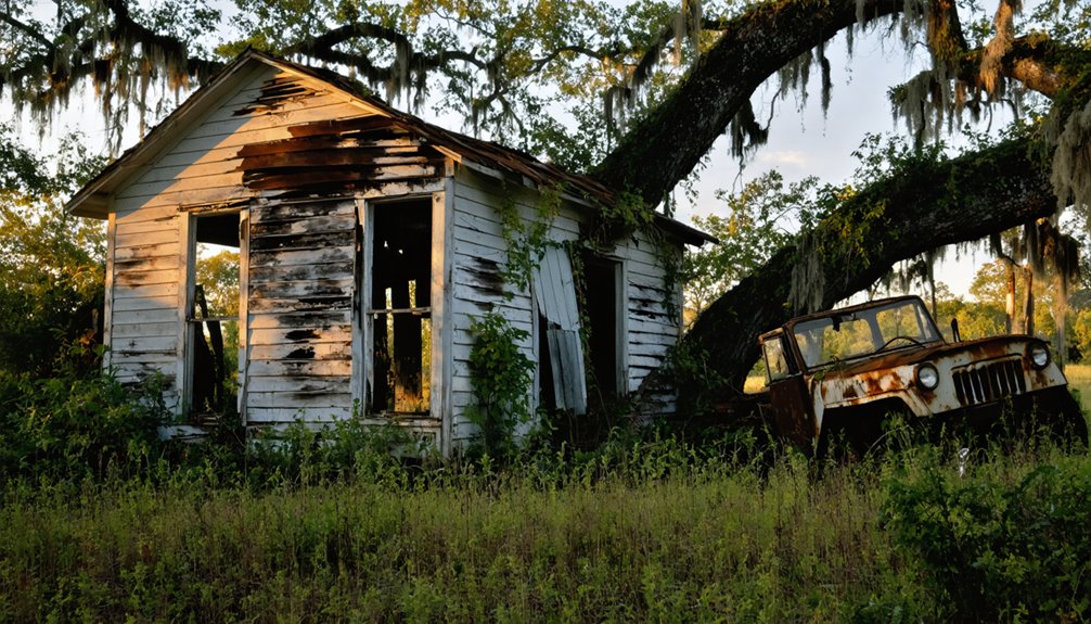
Anyone seeking to photograph one of Louisiana’s most haunting ghost towns will find Ruddock’s remnants particularly compelling.
From your drone’s vantage point, you’ll capture the eerie aftermath of the devastating 1915 hurricane that obliterated this once-thriving lumber settlement. The German immigrant settlers established a distinctly European character in the town before its destruction. The Ruddock ruins tell a stark story – rotting wooden structures peek through thick vegetation, while a solitary surviving house stands as a silent witness to nature’s fury.
Ruddock’s ghostly ruins whisper tales of destruction, where splintered dreams and weathered wood merge with the relentless Louisiana swamp.
Your aerial shots can document what remains of the stilt-supported infrastructure, now barely visible in the swampland. Visitors can still locate the area thanks to its designation as an exit on I-55.
The abandoned cemetery, with its disturbed headstones and upturned earth, offers particularly striking compositions from above. You’ll find prime shooting locations near the rebuilt railroad tracks, where the contrast between past and present creates haunting perspectives of this community that vanished in mere hours.
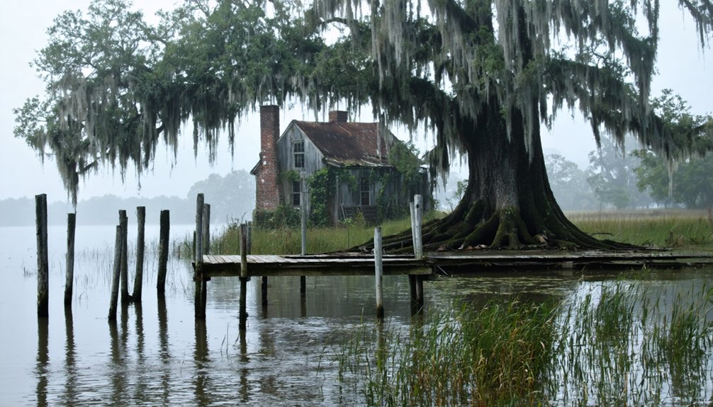
Mystical Aerial Views of Frenier’s Swamp Grounds
While Frenier’s swamp grounds harbor dark memories of the 1915 hurricane that decimated this Louisiana settlement, they now offer drone photographers an ethereal canvas of mystery and natural beauty.
You’ll discover haunting aerial reflections of cypress trees draped in Spanish moss, their ancient limbs reaching skyward through the morning mist. The overgrown Frenier Cemetery, accessible only through Cajun Pride Swamp Tours, reveals itself as a poignant reminder of the town’s tragic end.
Your drone footage can capture the interplay of swamp legends and reality, from Julia Brown’s weathered cabin to the mass graves that dot the wetland landscape. These remote areas provide exclusive photographic access without interference from other tour boats or visitors. Before launching your drone, remember to check that you’re flying within the Class G airspace restrictions of 400 feet maximum altitude.
For the most dramatic shots, arrive at dawn when golden light pierces the fog, transforming the mirror-like bayou into a photographer’s paradise of otherworldly compositions.
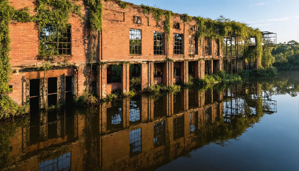
Laurel Valley’s Abandoned Industrial Legacy
Heading southeast from Frenier’s swampy mysteries, Louisiana’s largest surviving sugar plantation complex beckons drone photographers with its industrial ruins.
As the sun sets, shadows lengthen across the remnants of the past, creating an eerie beauty that draws in the more adventurous photographers. Those seeking unique perspectives can venture towards abandoned towns for night photography, where decaying buildings and overgrown landscapes provide a haunting backdrop. The stillness of the night amplifies the ethereal quality of these forgotten places, inviting exploration and creative expression.
You’ll find nearly 40 original structures dotting Laurel Valley‘s landscape, where the crumbling sugar mill stands as a monument to its industrial heritage. Your drone can capture the geometric patterns of worker cabins arranged in neat rows, while remnant plantation railroad tracks create compelling leading lines in your aerial compositions. The plantation once processed an impressive four million pounds of sugar during its peak operations. The site also housed a thriving community of 350 residents by 1910.
The site’s dramatic transformation from an 1800s sugar empire to today’s heritage village offers unique photographic contrasts.
You’ll discover weathered industrial elements juxtaposed against managed farmland, with the mill ruins providing vertical focal points for dramatic shots. The preserved blacksmith shop, store, and church buildings complete your visual narrative of this once-bustling industrial community.
Industrial Contrasts at Taft Cemetery
Deep in Louisiana’s industrial corridor, the Holy Rosary Cemetery in Taft presents one of the most striking visual contrasts you’ll find for drone photography.
You’ll capture haunting compositions where weathered headstone textures meet towering industrial silhouettes, especially during golden hour when long shadows stretch across the grounds.
Position your drone at low angles to frame the cemetery’s weathered monuments against massive storage tanks and distillation columns. For optimal technical support while flying in complex industrial zones, take advantage of the dedicated support team available to assist with flight planning and safety protocols.
With 1,684 memorials to explore, you’ll find countless compelling angles for your drone shots.
For maximum impact, try vertical shots that shift from intimate grave details to the sprawling chemical plant beyond.
Work with the natural lines formed by grave rows to lead viewers’ eyes toward the industrial backdrop.
Consider HDR techniques to balance the exposure between shaded markers and sun-reflecting metal, preserving details in both the sacred and industrial elements of your shot.
Submerged Landscapes of Burrwood and Elliot City
Located at the southernmost reaches of Louisiana’s Mississippi River delta, the submerged ruins of Burrwood present an otherworldly canvas for aerial photography.
You’ll find this ghost town’s remnants where the Mississippi meets the Gulf, marked only by a solitary pilots’ station rising from the marsh like a sentinel of the past.
Your drone can capture the haunting delta landscapes where a thousand residents once lived, now claimed by the sea.
The submerged structures of the naval base – heavy-duty docks that once supported destroyers and patrol craft – lurk beneath the waters.
Time your visit with the tides to glimpse traces of jetties and seawalls that failed to hold back the Gulf’s advance.
Since the last house surrendered to the waves in 2010, Burrwood’s story has become one of nature’s reclamation.
The town’s demise began with wave erosion and the gradual destruction of protective wetlands.
The devastating impact of Hurricane Betsy in 1965 marked a turning point in the town’s decline.
Frequently Asked Questions
What Drone Permits Are Required for Filming Ghost Towns in Louisiana?
Like accessing a secret door, you’ll need a Part 107 Remote Pilot Certificate, FAA registration, Remote ID compliance, landowner permission, and local filming permits to capture Louisiana’s ghost towns by drone.
Exploring ghost towns for movie settings in Louisiana offers a unique visual backdrop that can elevate any film’s atmosphere. From the decaying facades of forgotten buildings to the hauntingly quiet streets, each location tells a story of its own. Filmmakers are often drawn to these sites not only for their eerie beauty but also for the rich history that permeates the air.
There are numerous abandoned places in Louisiana that reveal the state’s deep-rooted past. Each site is not just an empty shell; they are relics filled with memories and intrigue, attracting adventurous souls and photographers alike. As twilight descends, the eerie charm of these forgotten locales becomes even more pronounced, ideal for capturing stunning visuals that resonate with history and mystery.
Are There Specific Seasonal Restrictions for Ghost Town Drone Photography?
You’ll face seasonal weather restrictions during hurricane season (June-November) and spring flooding. For best photography, shoot during winter’s leaf-off period, but watch for fog and reduced visibility conditions.
How Can Photographers Protect Equipment From Louisiana’s High Humidity?
In Louisiana’s suffocating heat, you’ll need silica gel packs for humidity control, sealed cases, and regular equipment maintenance. Store gear in climate-controlled spaces and use rain covers during coastal shoots.
What Emergency Facilities or Services Are Available Near These Locations?
You’ll find Level I trauma care in New Orleans, plus regional emergency services in St. John and Pointe Coupee parishes. Local hospitals, air medical evacuation, and water rescue teams cover most ghost-town areas.
Do Any Ghost Towns Require Advance Permission From Private Landowners?
You’ll need property access agreements for most sites, including Fort Proctor, Elliot City, and Laurel Valley. Contact landowners before visiting since these ghost towns sit on private parcels requiring explicit permission.
References
- https://thebayouinsider.substack.com/p/ghost-towns-and-forgotten-roads-louisianas
- https://etsn.fm/ixp/33/p/7-louisiana-ghost-towns/
- https://classicrock1051.com/17-ghost-towns-louisiana/
- https://www.atlasobscura.com/places/frenier-cemetery
- https://www.onlyinyourstate.com/trip-ideas/louisiana/underwater-ghost-town-la
- https://www.youtube.com/watch?v=EU0bCGNF13k
- https://999ktdy.com/8-photos-of-abandoned-fort-proctor-in-st-bernard-parish-louisiana/
- https://darktourists.com/ruddock-louisiana-entire-town-destroyed-by-hurricane/
- https://hnoc.org/publishing/first-draft/julia-brown-curse-hoodoo-hurricanes-and-storm-swamped-ruddock
- https://lobservateur.com/2015/09/30/ruddock-washed-away-100-years-ago/