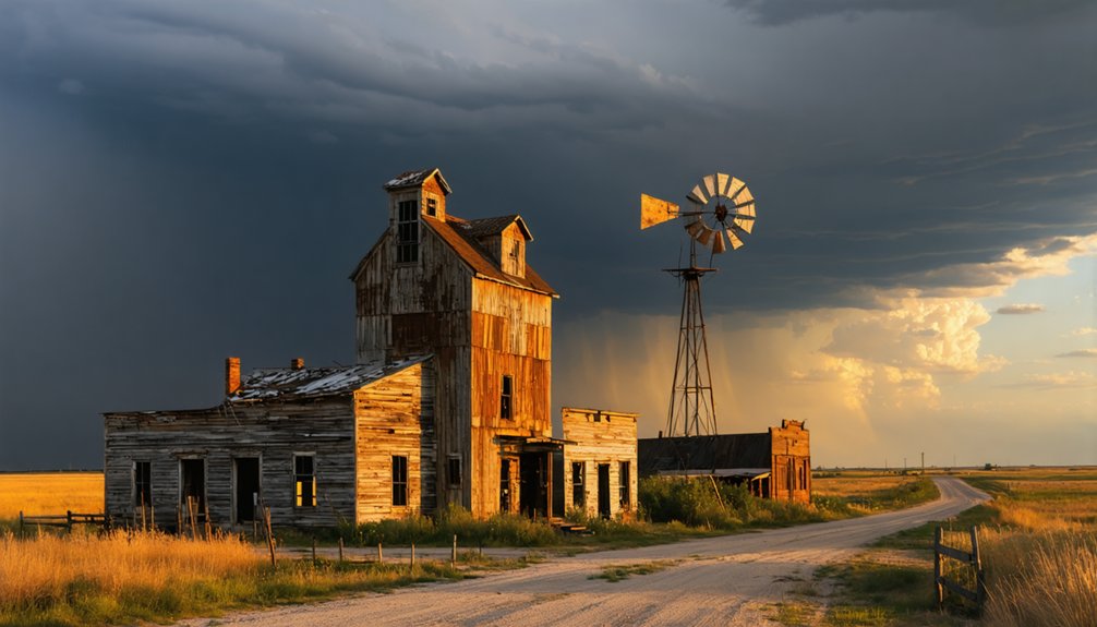
You’ll find prime drone photography opportunities in Michigan’s Keweenaw Peninsula, home to nearly 100 abandoned mining settlements from America’s first mineral rush. The region’s copper boom ghost towns, like Cliff Mine, offer dramatic structural remains and artifacts dating to 1840. Technical requirements include a drone with 30-minute flight time, 3-axis gimbal stabilization, and obstacle detection. The area’s seasonal variations and lighting conditions reveal hidden layers of historical detail waiting to be uncovered.
Key Takeaways
- The Keweenaw Peninsula in Michigan offers numerous ghost town sites with historic copper mining structures ideal for dramatic aerial photography.
- Central City in South Dakota features well-preserved 1800s architecture and mining remnants against stunning Black Hills backdrop.
- Picher, Oklahoma provides stark industrial landscapes with abandoned zinc mines and massive chat piles perfect for aerial exploration.
- Rush Ghost Town in Arkansas presents riverside ruins and mining structures amid Ozark Mountain scenery for compelling drone shots.
- Thurmond, West Virginia offers abandoned railroad infrastructure and intact period buildings along New River Gorge for atmospheric aerial captures.
The Forgotten Cities of Michigan’s Keweenaw Peninsula
While the discovery of copper in 1840 by Douglass Houghton sparked America’s first mineral rush, few realize that Michigan’s Keweenaw Peninsula once hosted nearly 100 ghost towns during its mining heyday.
You’ll find abundant abandoned architecture in settlements like Central, which housed over 1,200 people and produced 52 million pounds of copper before its 1898 closure.
The region’s historical narratives are preserved in sites like Cliff Mine, featuring the best-maintained 1840s mining remnants in the area. From 1845 to 1878, the Cliff Mine produced 38 million pounds of copper as America’s first successful copper mine.
For aerial photography, you can’t miss Gay’s waterfront stamp mill or Bete Grise’s collection of clapboard structures. Many visitors find remnants of old apple trees that mark where thriving communities once stood.
The Keweenaw Time Traveler App and MTU Archives will guide you through these remote locations, where the Great Depression and failed miners’ strikes led to their ultimate abandonment.
Essential Drone Equipment for Ghost Town Photography
Since ghost town photography demands specialized drone capabilities, your primary flight platform must meet several key technical requirements.
You’ll need a drone with at least 30 minutes of flight time per battery, equipped with a 3-axis gimbal-stabilized camera featuring a 1-inch or larger sensor. Obstacle detection and Return-to-Home systems are essential for maneuvering tight spaces safely.
Smart battery management becomes critical in remote locations. Pack 2-3 spare batteries and a portable power station for recharging. Consider carrying a rugged case to protect your equipment from dust and impacts during transportation. Always inform someone nearby about your exploration plans and expected drone flight schedule.
Your drone should accommodate external lights or LumeCubes for illuminating dark interiors. Don’t forget a high-visibility landing pad for safe takeoffs on uneven terrain.
Proper lighting attachments and secure landing zones transform challenging ghost town environments into manageable aerial photography locations.
For professional results, invest in ND filters and high-capacity memory cards capable of handling 4K video and RAW stills without bottlenecks.
Seasonal Considerations for Capturing Abandoned Sites
Beyond selecting the right equipment, your success in ghost town drone photography hinges on understanding seasonal patterns and their effects on both imagery and operations.
Many abandoned mining towns throughout the Midwest tell stories of economic decline after World War I, just like Garnet, Montana. You’ll find summer’s extended golden hours perfect for warm-light exterior shots, while winter’s low sun angles create dramatic shadows that emphasize architectural decay. Much like in Goldfield, where historic headframes create striking vertical elements against the desert sky, these architectural features become dramatic focal points for aerial photographers.
Weather impacts greatly affect your access and image quality – spring rains can make dirt roads impassable, and winter snow might block remote sites entirely.
Consider how seasonal lighting transforms your subjects: autumn’s vibrant foliage contrasts beautifully with rusted metal, while winter frost adds texture to deteriorating structures.
You’ll need to adapt your flight planning accordingly, managing battery life in cold conditions and scheduling shoots around ideal lighting windows for each season.
You’ll need to thoroughly research permit requirements and check FAA airspace maps before photographing ghost towns, as many sites fall within restricted zones or require special permissions.
Check property boundaries and ownership records since you must obtain consent from private landowners before flying over their property, even if it appears abandoned.
Federal requirements mandate FAA registration for drones over 0.55 pounds and compliance with altitude restrictions under 400 feet, while state regulations may impose additional constraints near historical sites or cultural landmarks. Consider using tools like the B4UFLY app to verify airspace clearance before each flight.
Department of Natural Resources rules restrict drone use within 100 yards of cultural and historical sites in Michigan.
Permit Research Before Flying
Before launching your drone at any ghost town location, thorough permit research is essential to guarantee compliance with multiple regulatory frameworks.
You’ll need to verify FAA requirements, including registration for drones over 0.55 pounds, TRUST certification for recreational flights, or Part 107 compliance for commercial photography. Commercial operators should plan for a minimum two weeks for permit processing.
Check state park and local agency permit types, as many require specific authorizations or restrict operations to designated areas. Proof of insurance must be shown before receiving approval to operate your drone.
For commercial photography, you’ll need to navigate additional permit requirements. The application process often involves contacting multiple authorities, securing liability insurance, and planning for extended processing times.
Don’t forget to investigate local ordinances that might impose extra restrictions. Since ghost towns may span different jurisdictions, you’ll need to identify and obtain permits from each relevant authority before your flight.
Restricted Airspace And Boundaries
Several critical airspace restrictions govern drone operations at ghost town locations, particularly those near federal lands and protected areas.
You’ll need to verify whether your target site lies within National Park boundaries, where drone flights are strictly prohibited, or National Forests, where they’re generally permitted below 400 feet.
Be aware that Wilderness Areas ban all drone operations under the 1964 Wilderness Act.
Check FAA Temporary Flight Restrictions before launching, as these change frequently and may affect ghost town access.
You must maintain visual line of sight and stay under 400 feet unless authorized.
In the Midwest, state-specific drone regulations vary – Wisconsin bans operations in most state parks, while Missouri requires special permits for conservation areas.
Remember that drone regulations and airspace awareness are essential for avoiding hefty fines and equipment confiscation.
Technical Tips for Aerial Ruins Photography
Capturing compelling aerial photographs of ghost town ruins demands precise technical control over both camera settings and drone operations.
You’ll want to master key aerial techniques by shooting in RAW format and using manual exposure controls to handle the extreme dynamic range common in abandoned structures.
- Calibrate your gimbal before flights and allow the drone to settle briefly when hovering to minimize vibration-induced blur in your shots.
- Set fast shutter speeds (1/500s minimum) to capture crisp structural details, and use bracketed exposures for high-contrast scenes.
- Monitor wind conditions carefully and maintain proper distance from structures while keeping emergency return-to-home altitudes above the highest points.
For ideal exposure settings, lock your camera’s settings when shooting high-contrast scenes and leverage HDR merging in post-processing to preserve both highlight and shadow detail across your compositions.
Best Times of Day for Ghost Town Drone Shots
You’ll find the most compelling ghost town drone shots during golden hour when long shadows and warm light create dramatic contrasts across deteriorating structures.
Morning fog and mist effects add ethereal depth to your aerial compositions while minimizing harsh reflections off metallic surfaces.
Overcast conditions provide consistently even lighting that reveals intricate architectural details and textures, though you’ll need to optimize your camera settings to compensate for reduced contrast.
Golden Hour Magic Light
When golden hour bathes abandoned buildings in warm, directional light, drone photographers gain a prime opportunity to showcase ghost towns in their most dramatic state.
You’ll want to arrive early and use apps like PhotoPills to track the sun’s position, ensuring ideal camera placement for those fleeting moments.
- Set your drone’s ISO between 100-200 initially, adjusting upward as light fades
- Position your craft at varying heights to capture elongated shadows and layered compositions
- Shoot in RAW with white balance at 6000-6500K to preserve those rich golden tones
During this magic hour, experiment with multiple exposures for HDR blending while flying both high and low.
Scout clear horizons beforehand and utilize foreground elements like structures or trees to add depth.
Remember to slightly underexpose to maintain vibrant colors in your final images.
Moody Overcast Shooting
Overcast conditions create ideal opportunities for moody ghost town drone photography, offering soft, diffused light that reveals intricate textures and weathered details often lost in harsh sunlight.
You’ll find prime shooting conditions during midday under thick cloud cover, when even illumination maximizes texture capture across your entire composition.
For enhanced moody atmospheres, target the late afternoon hours when overcast conditions occasionally thin, allowing subtle warmth to penetrate.
The post-storm period delivers particularly compelling results, with rain-saturated surfaces and puddle reflections adding dimensional contrast while maintaining the brooding aesthetic.
If you’re working with limited time, uniformly overcast dawn extends your shooting window beyond golden hour, providing consistent soft light without harsh shadows.
For maximum drama, shoot during overcast twilight when cool tones dominate and any remaining artificial lights create striking contrasts.
Morning Mist Effects
Morning mist provides exceptional opportunities for capturing ethereal drone footage of ghost towns, particularly during the prime window of 6-9 AM when temperature inversions trap moisture near ground level.
You’ll find ideal atmospheric conditions in valley locations where calm winds below 5 mph allow mist to pool around abandoned structures.
- Launch your drone at sunrise (around 7 AM) to capture golden hour light filtering through misty mornings, creating dramatic backlit effects.
- Position your craft 50-100 feet high for revealing mist textures over rooftops while maintaining stable hover modes.
- Exploit longer exposure times of 1-5 seconds to transform vapor movement into rolling cloud formations.
During winter months, these conditions often extend until 10 AM, giving you additional flight time before the rising temperatures dissipate the atmospheric drama.
Hidden Gems Along the Joliet Steel Mill Route
Nestled along Columbia Street in Will County, Illinois, the Joliet Iron Works Historic Site stands as a prime destination for aerial photographers seeking to capture America’s industrial heritage.
You’ll find extensive blast furnace foundations and rail infrastructure creating compelling geometric patterns perfect for overhead compositions.
The site’s abandoned structures offer rich opportunities for high-contrast monochrome shots, especially during golden hour when long shadows emphasize the ruinscape’s dramatic textures.
You’ll need to verify Forest Preserve District drone regulations and obtain necessary FAA clearances before flying.
For the best results, plan your visit during late fall through early spring when reduced foliage reveals more of the historic foundations.
Keep to designated paths while shooting, as many areas contain unstable materials, and consider combining your aerial work with shots of nearby rust-belt landmarks.
Preserving History Through Aerial Documentation
While industrial sites offer compelling drone photography opportunities, the broader mission of aerial documentation serves to preserve America’s vanishing historical landmarks. Through aerial archaeology techniques, you’ll capture thorough records of ghost towns before they succumb to nature’s reclamation. Your drone heritage documentation creates invaluable 3D models and high-resolution imagery that verify historical accuracy against original town footprints.
- Thermal imaging reveals hidden structural weaknesses, enabling preservation teams to prioritize stabilization efforts.
- Time-lapse sequences track vegetation patterns and decay progression across entire town layouts.
- 360-degree scans generate interactive models for virtual tourism and educational outreach.
You’ll contribute to historical archives while avoiding physical disturbance of fragile structures – critical for sites like Capa, South Dakota, where abandoned hotels and mineral baths tell stories of bygone eras.
Frequently Asked Questions
Are There Any Paranormal Activity Reports From Drone Footage in These Locations?
You’ll find unverified reports of drone sightings showing mysterious lights and ghostly apparitions, but there’s no scientifically-validated evidence – most incidents are likely camera artifacts or environmental effects.
What Wildlife Hazards Should Drone Pilots Watch for in Abandoned Towns?
You’ll need to watch for territorial raptors dive-bombing drones, deer bolting unexpectedly, coyote packs near dens, and large bird swarms that can destabilize your aircraft during migration seasons.
How Do Extreme Winter Conditions Affect Drone Batteries in Upper Peninsula?
You’ll experience severe battery performance drops when flying in the UP’s cold weather, with flight times cut 50% below 15°C and potential sudden failures below -10°C. Keep batteries warm pre-flight.
Which Ghost Towns Allow Night Drone Photography With Proper Permits?
You’ll find legal night drone access in Capa and rural Keweenaw towns, where ghost town regulations are minimal. Gary requires city permits, while most Midwest locations need standard FAA Part 107 night photography permits.
Can Drones Detect Unstable Structures Before They Collapse in Old Towns?
You’ll find modern drone technology can effectively predict structural integrity issues through LiDAR, thermal imaging, and multispectral analysis, detecting instabilities with 85-95% accuracy before catastrophic collapse occurs.
References
- https://www.youtube.com/watch?v=7-vjuqiGWJU
- https://www.geotab.com/ghost-towns/
- https://www.youtube.com/watch?v=QozyDWwHWTc
- https://www.atlasobscura.com/lists/abandoned-places-midwest
- https://www.youtube.com/watch?v=15KsasKUnQ8
- https://www.visitkeweenaw.com/things-to-do/museums-history/ghost-towns/
- https://www.visitkeweenaw.com/blog/post/our-top-7-keweenaw-ghost-towns-to-explore/
- https://exploringthenorth.com/ghost/towns.html
- https://www.keweenawhistory.org/Central
- https://enjoyer.com/discovering-the-ghost-towns-of-the-keweenaw/


