You’ll find exceptional drone photography opportunities at Nebraska’s ghost towns, where expansive prairie landscapes meet historic frontier remnants. Key locations like Keystone and Broadwater offer dramatic compositions with abandoned storefronts, vintage signage, and geometric patterns from former rail lines. Shoot during golden hour for ideal lighting, when long shadows emphasize structural details and textures. Scout locations like Whitney’s railroad junction and Minatare’s city hall for compelling aerial perspectives. Discover how these forgotten settlements reveal their stories from above.
Key Takeaways
- Keystone offers exceptional aerial opportunities with abandoned storefronts and a working post office against expansive prairie landscapes.
- Broadwater’s early 20th-century motel and vintage signage create compelling compositions during golden hour photography sessions.
- Minatare’s historic city hall with artistic murals provides vibrant aerial shots and strong architectural elements.
- Whitney’s abandoned railroad junction delivers dramatic perspectives with clear vanishing points and geometric patterns.
- Lewis and Clark Lake area combines historical structures with rugged terrain, offering diverse shooting angles and natural backdrops.
What Makes Nebraska Ghost Towns Perfect for Aerial Photography
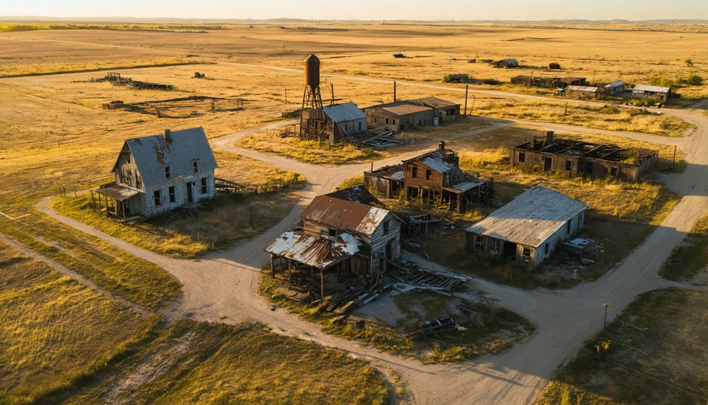
While many states offer abandoned locations for drone photography, Nebraska’s ghost towns present an unmatched combination of advantages for aerial imaging. The state’s expansive prairie landscape provides unobstructed sightlines and dramatic geometric patterns from abandoned rail lines, field boundaries, and town grids that showcase historical significance from above.
You’ll find perfect conditions for capturing aerial perspectives, with low tree cover revealing foundation outlines and archaeological traces. Historic land development companies surveyed and plotted many of these towns, creating visually striking grid patterns perfect for drone shots. Near the Sandhills region, which covers one-third of Nebraska, these abandoned settlements offer stunning natural backdrops against weathered structures. The region’s dramatic weather patterns create stunning backdrops, while seasonal changes highlight structural remains against natural elements.
Wide horizons maximize golden-hour shooting, and the subtle topography near ghost towns offers natural elevated vantage points. Nebraska’s sparse population and minimal controlled airspace make it exceptionally drone-friendly, with easy access to launch sites and clear flight paths.
Essential Gear and Legal Requirements for Drone Flights
Before launching your drone over Nebraska’s ghost towns, you’ll need to navigate a crucial framework of legal requirements and essential equipment. The state’s drone regulations require careful attention to both federal and local guidelines while capturing these historic sites. Per FAA rules, all hobbyist pilots must complete a knowledge test. State park areas are off-limits for drone flights according to Nebraska Game & Parks Commission regulations.
When exploring the eerie charm of ghost towns in Nebraska cinema, consider the stories these abandoned places hold. Each decaying structure tells a tale of the past, providing a haunting backdrop for filmmakers looking to capture the essence of desolation. Embrace the landscape’s unique aesthetic while ensuring that your drone captures the cinematic atmosphere without infringing on local regulations.
- Register your drone with the FAA if it weighs over 0.55 lbs and complete TRUST certification for recreational flights or obtain a Part 107 license for commercial photography.
- Equip your drone with Remote ID broadcasting capability and carry proof of registration during flights.
- Scout locations for airspace restrictions, staying under 400 feet in Class G airspace and obtaining LAANC authorization when needed.
- Pack essential photography equipment including drone insurance, visual observers for complex shots, and secure hardware that meets state standards.
Top Ghost Town Locations and Their Unique Features
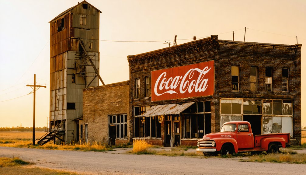
Nebraska’s abandoned towns offer photographers an extensive network of historically rich locations perfect for drone photography. Keystone aesthetics shine through its Main Street’s abandoned storefronts and operating post office, creating compelling linear compositions and symmetrical shots along old railbeds.
You’ll find Broadwater textures particularly striking at golden hour, where the early 20th-century motel and railway corridor showcase weathered façades and vintage signage. In Minatare, the historic city hall features artistic murals that add vibrant pops of color to aerial compositions.
For dramatic aerial perspectives, head to Whitney’s former railroad junction, where stone storefronts and empty track beds provide strong vanishing points. Grain elevators punctuate these ghost town skylines, offering vertical landmarks against vast prairie skies. The rugged terrain near Lewis and Clark Lake once provided refuge for Jesse James’ gang, making it a historically significant area for aerial documentation.
Don’t miss the quarried stone churches and small-town cemeteries, which create powerful subjects for dawn and dusk silhouette photography.
Best Times and Weather Conditions for Ghost Town Drone Shots
You’ll maximize your ghost town drone photography by shooting during golden hour (30-60 minutes after sunrise or before sunset), when Nebraska’s low-angle light creates dramatic shadows and textures across weathered buildings.
For those looking to capture stunning night skies, exploring the top astrophotography spots in Nebraska can yield breathtaking results. Locations like the Sandhills and the Niobrara National Scenic River offer minimal light pollution, ideal for photographing stars, galaxies, and the Milky Way. Be sure to plan your visit around a new moon for the best visibility and a truly enchanting experience.
For ideal aerial stability, plan your flights during calm conditions with winds under 10 mph and either overcast skies for soft, diffused light or clear skies during golden hour for maximum color saturation. The abandoned phone booth in Brewster makes an especially compelling subject for aerial compositions.
Your seasonal timing matters too – late autumn reveals clear structural views with warm leaf colors, while winter snow emphasizes stark geometries despite requiring careful battery management in cold conditions.
Golden Hour Magic Tips
While golden hour presents prime opportunities for drone photography, capturing Nebraska ghost towns during these fleeting moments requires precise timing and preparation. Understanding light dynamics is essential for maximizing your shoot’s potential during these narrow windows of magical illumination. The warm reddish tones create an ethereal glow that enhances weathered buildings and abandoned structures.
- Plan your arrival 30-45 minutes before golden hour’s midpoint, which typically spans 20-75 minutes after sunrise or before sunset, depending on season and latitude. Using a polarizing filter will help enhance colors and reduce unwanted glare from reflective surfaces.
- Monitor weather forecasts for clear skies with thin high clouds, aiming for winds under 15 mph to guarantee stable flight conditions.
- Shoot in RAW with 3-7 bracketed exposures (±1/3 to ±1 EV) to capture the full dynamic range of golden-hour scenes.
- Choose sunrise shoots for minimal human presence and morning mist, or sunset sessions for richer skies and dramatic cloud formations.
Seasonal Weather Planning Guide
Successful ghost town drone photography depends heavily on selecting ideal seasonal conditions that align with your creative vision and technical requirements.
You’ll find Nebraska’s late autumn and early winter months offer compelling advantages – stark lighting, high contrast landscapes, and minimal vegetation obscuring historic foundations. The abundance of grain elevators and silos provides striking vertical elements against the horizon. Just monitor drone regulations and weather patterns carefully during these seasons.
For best results, launch during calm winds under 15 mph and clear to partly cloudy skies.
You’ll need to adapt your approach in cold conditions by keeping spare batteries warm and reducing flight times by up to 50%.
Early autumn provides an excellent alternative with crisp air, peak visibility, and vibrant color contrasts, while avoiding winter’s harsh operating constraints.
Always check local METAR forecasts and maintain visual line of sight for safe, compliant operations.
Capturing History From Above: Photography Tips and Techniques
As drone photography transforms how we document ghost towns, mastering the right technical approach and composition strategies becomes vital for capturing these historic sites from above. Your aerial imagery will reveal stories that ground-level shots can’t tell, while preserving essential details for future generations.
Aerial drone photography unlocks hidden narratives of abandoned places, preserving their haunting beauty and historical significance for generations to come.
- Start with RAW format shooting at varied heights (10-50m) to capture both textures and context, using early morning or late afternoon light when shadows reveal hidden structural details.
- Employ mixed nadir and oblique shots with 80% forward overlap for your mapping sequences, keeping your shutter speed fast enough to guarantee sharpness.
- Follow the rule of thirds with decaying roads and foundation lines as natural guides, creating storytelling angles that draw viewers through the scene.
- Use bracketing in challenging light conditions, especially when shooting against bright skies or into dark building interiors.
Planning Your Nebraska Ghost Town Drone Adventure
Before launching your Nebraska ghost town drone expedition, you’ll need to navigate a complex web of regulations, safety protocols, and logistical requirements.
Start with FAA Part 107 compliance if you’re flying commercially, or verify recreational rules for your chosen locations. Check NOTAMs and local airspace restrictions carefully.
Your site selection should focus on ghost towns offering diverse visual elements – standing structures, foundations, and historic landscapes.
Use historic maps and aerial imagery for route planning, identifying hidden features that aren’t visible from ground level. Pre-screen access roads using satellite imagery and county maps to avoid wasted trips on impassable routes.
Pack redundant power sources, emergency supplies, and offline maps.
File flight plans with a ground contact when operating in remote areas, and always scout potential launch sites during daylight hours.
Frequently Asked Questions
Are There Any Paranormal Activity Reports From These Ghost Towns?
Like many tales from the Old West, you’ll find plenty of unverified paranormal sightings and haunted history claims, but no scientifically documented evidence exists beyond atmospheric conditions and visitor testimonials.
How Safe Are These Locations From Wild Animals and Trespassers?
You’ll face minimal wildlife encounters beyond non-threatening rabbits and birds. While these sites are remote, you’ll need to respect trespassing laws since many locations sit on private property.
Can Metal Detectors Be Used While Visiting These Ghost Towns?
Like fading footprints in time, historical artifacts are protected. You’ll need permits for state lands and owner permission for private ghost towns. Metal detecting regulations strictly limit exploration to preserve Nebraska’s heritage.
Which Ghost Towns Have Cell Phone Reception for Emergency Situations?
You’ll find reliable cell service near Amboy and Long Pine ghost towns, while Keystone offers basic coverage. Northwestern sites like Whitney have spotty reception – pack satellite communication for emergency preparedness.
Are Guided Tours Available for Any of These Ghost Towns?
You won’t find organized guided tours at these locations, though they hold historical significance. You’re free to explore Amboy, Keystone, Pineview Drive-In, and Whitney independently via public access routes.
References
- https://www.onlyinyourstate.com/trip-ideas/nebraska/ne-ghost-towns-road-trip
- https://history.nebraska.gov/finding-nebraskas-ghost-towns/
- https://www.youtube.com/watch?v=q1Bww945Vhc
- https://www.youtube.com/watch?v=gT2faoIOoAA
- https://www.youtube.com/watch?v=Iw21dwaXkck
- https://freepages.history.rootsweb.com/~gtusa/usa/ne/sarpy-co.htm
- https://visitnebraska.com/trip-idea/explore-7-authentic-ghost-towns-nebraska
- https://www.journeyoflight.com/blog/the-10-best-places-to-photograph-in-nebraska/
- https://www.homestratosphere.com/secluded-towns-in-western-nebraska/
- https://drone-laws.com/drone-laws-in-nebraska/


