You’ll find prime drone photography at the Auburn Mining District near Baker City, Oregon, where gold rush remnants scatter the landscape. Washington’s abandoned railroad settlements like Corfu and Govan offer compelling aerial compositions of isolated structures. The Palouse region reveals forgotten agricultural towns amid rolling wheat fields, while coastal sites like Washaway Beach showcase dramatic maritime ruins. Plan your flights during summer months (July-September) when clear skies and calm winds create ideal shooting conditions. These historic locations hold countless untold stories waiting to be captured from above.
Key Takeaways
- Auburn Mining District near Baker City, Oregon offers expansive aerial views of historic gold rush remnants and subtle terrain changes.
- The Palouse Region’s abandoned agricultural settlements provide stunning compositions against rolling wheat fields during July-August peak season.
- Washington State’s railroad ghost towns, including Corfu and Wellington, feature isolated structures perfect for dramatic aerial reveals.
- Coastal ghost features at Washaway Beach showcase dramatic erosion patterns and abandoned maritime structures during low tide.
- Golden hour flights (sunrise/sunset) between July-September provide optimal lighting conditions and stable flying weather for ghost town photography.
Essential Drone Equipment for Ghost Town Photography
When capturing ghost towns from above, your primary drone setup needs to combine portability with image quality.
You’ll want a lightweight folding quadcopter with a 1-inch or larger sensor to handle the challenging light conditions these abandoned sites present. Similar to how over 20,000 mines once dotted Colorado’s landscape, drone photography allows us to document these vast historical remnants from above. The DJI Smart Case provides essential on-location charging capability when exploring remote ghost towns. For the best drone gear essentials, pack a 3-axis mechanical gimbal to achieve those smooth cinematic reveals across weathered structures.
Consider bringing a backup drone for remote locations where recovery might be difficult. Include ND filters and polarizers to manage harsh daylight and reflective surfaces – essential photography tips for capturing the authentic mood of these historic sites.
Pack multiple flight batteries and a portable charging solution, as cold Pacific Northwest temperatures can reduce flight time by up to 30%. A cinewhoop system proves invaluable for those tight interior shots where precision matters most.
Weather and Seasonal Considerations for Pacific Northwest Flights
You’ll find ideal ghost town photography conditions during summer months when the Pacific Northwest experiences calmer winds and clearer skies, typically from July through September.
Winter flights carry significant risks due to increased precipitation, reduced visibility, and gusty conditions that can destabilize your drone, particularly near coastal and mountainous ghost town sites. Consider checking the pilot activity data in your target area to coordinate with other drone photographers and maintain safe flying distances. Access to real-time METAR data through government weather systems provides critical aviation weather updates for drone operators.
For the best results, schedule your shoots during early morning golden hours when winds are typically calmest, while monitoring real-time weather data through apps like Sonuby for sudden changes in conditions.
Peak Season Flight Times
The Pacific Northwest‘s prime drone photography season unfolds from May through September, offering photographers ideal conditions for capturing ghost town imagery.
You’ll find the most stable flight conditions after the Fourth of July, when clear skies and minimal precipitation create perfect aerial shooting opportunities.
Plan your flights around sunrise for soft, directional light that reveals intricate building details, or schedule sunset sessions to capture the warm glow on weathered structures. Consider using a 24-70mm lens for versatile ground-based complementary shots between drone flights. Recent years have shown less summer fog which improves visibility for aerial photography.
Avoid midday flights when harsh shadows can obscure architectural features. For coastal ghost towns, target late March to May when dramatic storm clearings create moody atmospheric conditions.
Position yourself with the sun behind your subject to maximize texture and depth in your compositions. Late summer’s extended daylight hours provide additional flexibility for timing your shots.
Winter Weather Flight Risks
Four major hazards threaten winter drone flights in Pacific Northwest ghost towns: icing, battery strain, precipitation damage, and wind instability.
When temperatures hover near freezing, ice forms on propellers and sensors, causing erratic flight patterns and potential crashes. The temperature-dew point spread indicates when icing conditions are most likely to develop. You’ll face rapid battery drain below -10°C, requiring preheated batteries and shortened flight times. Touch-screen gloves are essential for maintaining control during extended winter flights.
Winter flight risks intensify with snow and rain – moisture wreaks havoc on electronics, leading to sensor fogging and ESC failure.
Precipitation challenges combine with gusty mountain winds above 15 mph to create treacherous conditions. The snow-blanketed terrain masks obstacles while reducing visual contrast.
To protect your drone, use launch pads to avoid snow contact, maintain warm batteries, and monitor temperature-dew point spread.
Skip flights during active snowfall and guarantee your craft has proper moisture protection ratings.
Top Abandoned Mining Sites in Eastern Oregon
You’ll find Eastern Oregon’s richest drone photography opportunities at the Historic Sumpter Valley Dredge, where the massive gold mining machine stands frozen in time against dramatic mountain backdrops.
The crumbling 19th-century structures of Granite Ghost Town provide stark vertical elements for aerial composition, with its weathered schoolhouse and church creating compelling shadows during golden hour shoots. At its peak, the town supported a bustling community of five thousand residents. Near Granite, the haunting ruins of Cabell City showcase some of the region’s best-preserved buildings from the mining era.
The Auburn Mining District‘s scattered remnants offer unique perspectives of pioneer-era mining operations, featuring eroded tailings piles and abandoned equipment that create striking patterns when captured from above.
Historic Sumpter Valley Dredge
Standing as a tribute to Oregon’s gold mining heritage, Sumpter Valley’s massive dredge dominates the landscape 30 miles west of Baker City. This industrial behemoth, which extracted over $10 million in gold between 1935 and 1954, offers dramatic aerial photography opportunities against the rugged Elkhorn Mountains backdrop.
You’ll find the 93-acre site perfect for drone shots, with its distinctive conical tailing piles creating an otherworldly terrain. The dredge’s weathered exterior, complete with 72 one-ton buckets and complex sorting mechanisms, provides compelling compositions from above.
The structure’s scale becomes especially apparent when captured from elevation, while its rusted patina tells the story of decades exposed to the elements. For the best lighting, shoot during golden hour when shadows play across the moonscape-like surroundings.
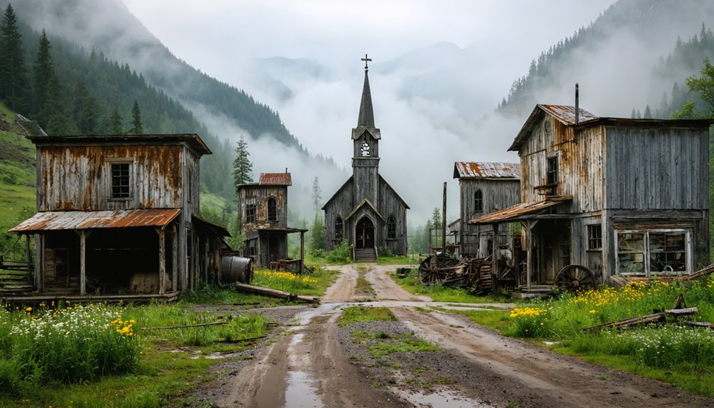
Granite Ghost Town Ruins
Nestled in a remote canyon of Oregon’s Blue Mountains, the historic ruins of Granite ghost town offer drone photographers an atmospheric glimpse into the state’s gold rush era.
You’ll find weathered 19th-century structures, including a schoolhouse, church, and dance hall, scattered along Granite Creek’s banks.
To capture Granite’s history from above, you’ll need to navigate challenging conditions. Plan your shoot during summer or early fall when access roads are most manageable.
Watch for GPS interference from old mining sites, and keep your drone within visual range due to the canyon’s signal-limiting topography.
Before launching, scout stable takeoff spots away from deteriorating structures and obtain necessary permissions – you’re dealing with a mix of private, BLM, and Forest Service lands.
Pack spare batteries and emergency gear; you’re 60 miles from the nearest services in Baker City.
Auburn Mining District Remnants
While virtually nothing remains of eastern Oregon’s largest gold rush settlement today, the Auburn Mining District offers drone photographers a unique opportunity to document the ghostly footprint of a once-thriving boomtown.
Your aerial footage can capture the sprawling landscape where 6,000 miners once sought their fortunes using placer mining techniques along Griffin Creek. The site, eight miles southwest of Baker City, peaked in 1863 before rapidly declining as prospectors left for Idaho’s goldfields.
You’ll want to focus your lens on the confluence of Blue Canyon and Freezeout creeks, where the most intense mining activity occurred. Though the buildings have vanished, drone photography can reveal subtle terrain changes and foundations that hint at Auburn’s history as Baker County’s first seat and northeastern Oregon’s earliest postal station.
Historic Railroad Ghost Towns of Washington State
Scattered across Washington State’s diverse landscapes, historic railroad ghost towns offer drone photographers compelling opportunities to document the remnants of America’s rail-transportation heritage.
You’ll find prime aerial compositions at Corfu’s desert freight hub, where the Milwaukee Road’s grade cuts through semi-arid terrain.
The Govan/Sherman corridor presents lowland vistas punctuated by isolated structures and historic cemeteries, perfect for capturing the human footprint along former Central Washington Railway routes.
Wellington’s dramatic mountain setting showcases abandoned grades against forested Cascade slopes, while Melmont’s coal mining heritage unfolds along the Carbon River trail.
Before launching your drone, verify property boundaries and FAA regulations – many sites span private lands or lie near active rail corridors.
Palouse Region’s Forgotten Agricultural Settlements
The rolling hills of Washington’s Palouse region conceal a network of abandoned agricultural settlements that offer drone photographers exceptional compositional opportunities.
You’ll discover haunting reminders of the area’s agricultural decline through your lens, from crumbling foundations to deserted homesteads.
- Capture Elberton’s dramatic landscape where the Palouse River cuts 300 feet below, framing historic trestles and the 1913 United Brethren Church against basalt cliffs.
- Frame Govan’s weathered schoolhouse and towering grain elevators against waves of golden wheat fields (peak season: July-August).
- Document the contrast between pioneering settlements and encroaching wilderness, where young forests reclaim former farmlands.
- Explore isolated structures amid the undulating Palouse hills, showcasing the region’s unique glacial topography through sweeping aerial perspectives.
Coastal Ghost Features and Maritime Ruins
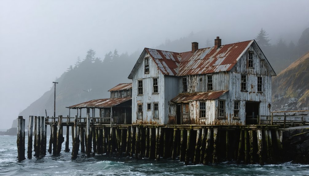
Along the Pacific Northwest coastline, dramatic scenes of erosion and maritime decay create compelling subjects for drone photography.
You’ll find prime shooting locations at Washaway Beach, where coastal erosion claims up to 100 feet of shoreline annually, revealing dramatic exposed foundations and cliffed graveyards.
For maritime landscapes, explore Gold Beach’s Mary D. Hume wreck or scan Tillamook Bay’s shallow waters for the submerged ruins of Bayocean resort.
Time your flights with low tide to capture abandoned sternwheels and derelict fishing vessels in coastal estuaries.
Document the human response to shoreline retreat through relocated cemeteries and settlements, or frame the geometric patterns of collapsed cannery pilings from above.
These deteriorating coastal features offer unique opportunities for both documentary and artistic aerial compositions.
Safety and Legal Guidelines for Historic Site Operations
Before launching your drone at historic sites across the Pacific Northwest, you’ll need to navigate a complex web of federal, state, and local regulations.
Operating drones near Pacific Northwest historic sites requires careful navigation of overlapping regulations at multiple government levels.
Beyond FAA Part 107 certification and Remote ID compliance, most historic locations require specific drone operation permits and insurance coverage.
- Submit permit applications 30-60 days ahead for commercial shoots at state parks and historic sites.
- Secure minimum $100,000 liability insurance and provide Certificate of Insurance with site-specific endorsements.
- Prepare detailed flight plans showing takeoff/landing zones and maintain visual line-of-sight operations.
- Document pre-flight safety assessments including airspace checks, crowd density, and wildlife considerations.
Remember that each jurisdiction has unique historic site regulations – from Washington’s state parks to Oregon’s protected landmarks.
You’ll need written permission for landing zones and must report any incidents immediately to the permitting agency.
Frequently Asked Questions
How Do You Locate Undocumented Ghost Towns Not Listed in Tourist Guides?
You’ll need to combine urban exploration with historical research – study old maps, analyze satellite imagery, join local explorer networks, and scan declassified aerial photos for structural remnants.
What Special Permits Are Needed for Commercial Drone Footage of Ghost Towns?
You’ll need an FAA Part 107 license, state registration in WA/OR, plus special filming permits if the ghost town’s on National Forest land. Contact local authorities for site-specific requirements.
Are There Ghost Towns Completely Off-Limits to Drone Photography?
Yes, you’ll find many ghost towns completely off-limits due to legal restrictions in Wilderness Areas, National Parks, military zones, and cultural sites. Always check drone etiquette and permits before flying.
How Close Can Drones Safely Fly to Deteriorating Historic Structures?
While you’ll want epic shots, drone safety demands staying 15-30 feet from crumbling walls. You’re protecting historic preservation and your gear – deteriorating structures can collapse or interfere with flight controls.
Which Ghost Towns Allow Night or Low-Light Drone Operations?
You’ll find legal night operations in remote BLM ghost towns like Silver City, Idaho, while low-light conditions work best at Bodie State Park’s edges before sunset, staying outside restricted boundaries.
References
- https://www.airvuz.com/collection/video/drone-videos-of-the-usas-pacific-northwest?id=B1ZAus2bW
- http://pnwphotoblog.com/ghost-towns/
- https://thatoregonlife.com/2016/04/road-trip-ghost-towns-eastern-oregon/
- https://nvtami.com/2022/11/13/humboldt-pershing-county-ghost-towns/
- https://stateofwatourism.com/ghost-towns-of-washington-state/
- https://www.youtube.com/watch?v=JnIIQymTY3w
- https://www.youtube.com/watch?v=CuEIWySDQ20
- https://explorewashingtonstate.com/tim-nyhus-ghost-towns-abandoned-mines-and-the-thrill-of-discovery-in-washington/
- https://photographerstrailnotes.com/colorado-preview/a-room-wtih-a-view-photographers-guide
- https://www.youtube.com/watch?v=1Vd4pkusiwc


