You’ll find exceptional drone photography opportunities at Arizona’s historic ghost towns like Goldfield, Vulture City, and Gold King Mine. These sites offer dramatic compositions of preserved mining structures against mountain backdrops and desert landscapes. Goldfield’s Main Street and Vulture City’s Glory Hole mining site provide compelling aerial perspectives, while winter mornings between 10 AM and noon offer ideal flying conditions with calm winds. The intricate details of these abandoned boomtowns reveal themselves best from above.
Key Takeaways
- Goldfield Ghost Town in Arizona offers dramatic Superstition Mountains backdrops and preserved mining structures perfect for aerial photography.
- Vulture City provides eighteen restored buildings and extensive mining heritage sites, accessible October through May for optimal drone shots.
- Ruby Hill features a flooded Fad Shaft and sprawling mining complex, creating stunning overhead composition opportunities.
- Rhyolite’s preserved bottle house and train depot offer unique architectural elements against Nevada’s Bullfrog Hills backdrop.
- Ward’s stone charcoal kilns create distinctive geometric patterns visible from above, ideal for abstract aerial compositions.
Understanding Drone Photography Regulations in Ghost Towns
While capturing haunting images of abandoned settlements may seem straightforward, drone photography at ghost towns requires careful navigation of multiple regulatory frameworks.
You’ll need to determine whether your shoot qualifies as recreational or commercial under FAA rules, as this affects registration and certification requirements. Commercial operations demand Part 107 certification, while recreational flights require TRUST test completion.
Before launching your drone, you must verify the ghost town’s location relative to federal lands, as National Parks and Wilderness Areas prohibit drone flights entirely. Violations can result in hefty fines up to $5,000 and possible confiscation of equipment. Maintaining a maximum altitude of 400 feet is mandatory regardless of location.
State privacy laws and trespass regulations also impact your shoot – you’ll need landowner permission for takeoffs and landings.
Remember that capturing images of private property, even in seemingly abandoned locations, may trigger privacy concerns and legal exposure. Always check local restrictions and maintain visual line-of-sight during operations.
Essential Gear and Equipment for Ghost Town Aerial Shoots
Selecting the right gear combination proves critical for successful ghost town drone photography.
Equipment selection can make or break your ghost town drone photography mission, so choose your gear wisely.
You’ll need a versatile drone like the DJI Mavic Pro for initial scouting, while the Mavic Air 2 excels in rugged terrain. For aerial composition, consider using a GoPro Max 360 or GoPro 9 to capture immersive views of decaying structures.
Recording in manual mode helps prevent missing crucial footage during exploration flights.
Proper drone maintenance demands high-capacity SD cards optimized for continuous recording and fast write speeds.
Don’t forget essential support gear like propeller guards and cleaning kits to protect your equipment from dust and debris. A sturdy camera bag designed for drone equipment will safely transport your gear across challenging terrain.
For extensive coverage, pair your drone with ground-based cameras like the Canon T7i, and always keep headlamps handy for maneuvering shadowy areas during pre-flight checks.
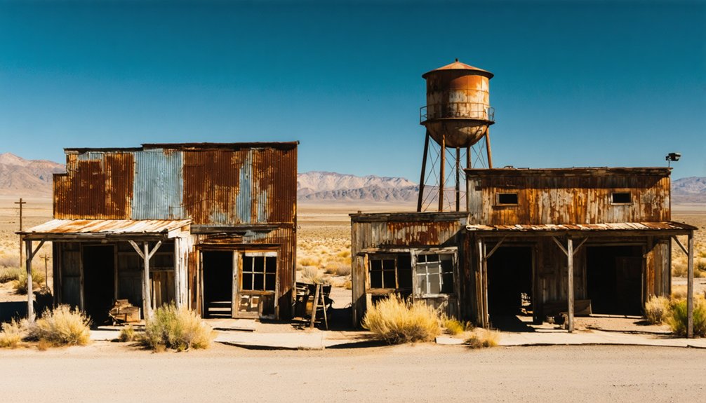
Top Ghost Town Locations in Arizona
You’ll find exceptional aerial photography opportunities at Goldfield Ghost Town, where the dramatic Superstition Mountains provide a stunning backdrop for capturing the town’s preserved mining structures and equipment.
Vulture City’s sprawling collection of restored buildings, including the garage, bank, and bunkhouse, offers compelling compositions that showcase Arizona’s rich mining heritage. The site has become a popular venue for parties and concerts under its new ownership.
At Gold King Mine in Jerome, you can leverage the mountainside elevation to frame dramatic shots of vintage vehicles and mining equipment against the Verde Valley’s sweeping vistas. The remote ghost town of Sundad provides unique photography potential with its abandoned mining shacks scattered throughout the surrounding hills.
Goldfield’s Prime Photo Spots
Located in Arizona’s Superstition Mountains, Goldfield’s historic district offers drone photographers an impressive array of architectural and natural compositions.
You’ll capture dramatic shots of abandoned structures along Main Street, where restored 1890s facades create compelling textural elements against the rugged mountain backdrop. These buildings once housed a thriving community of over 1,000 residents. Visitors can explore these photogenic structures without paying any entry fees. The Mammoth Mine entrance provides unique angles of mining artifacts and historic tunnels, while the water tower ruins offer isolated perspectives of the town’s industrial past.
For dynamic aerial compositions, position your drone above the narrow gauge railroad tracks or zipline installation. The mill site foundations and cyanide plant remains create stark geometric patterns when photographed from above.
Don’t miss the opportunity to document the Goldfield Museum’s exterior and the authentic period buildings that line the streets, especially during the golden hour when shadows emphasize the town’s weathered character.
Vulture City’s Historic Highlights
Three miles south of Wickenburg, Arizona, Vulture City stands as one of the territory’s most productive gold mining settlements, offering drone photographers an unparalleled glimpse into 1860s frontier life.
The historical significance of this site stems from Henry Wickenburg’s 1863 discovery of a massive gold vein that ultimately yielded over 340,000 ounces of gold. The town’s infamous hanging tree still remains as a stark reminder of frontier justice. The tragic Glory Hole incident in 1923 claimed the lives of seven miners and twelve pack animals when support pillars collapsed.
- Restored Assay Office provides striking architectural angles against desert backdrop
- Original Glory Hole mining site showcases dramatic 100-foot deep excavation
- Historic brothel and Wickenburg’s cabin offer authentic period structures
- Remnants of the 5,000-person boomtown layout reveal street grid patterns
- Preserved cookhouse and mess hall structures demonstrate frontier life
You’ll find eighteen restored buildings across the site, accessible October through May, making it an ideal location for capturing Arizona’s mining heritage from above.
Jerome’s Mountain Views
Perched dramatically at 5,200 feet atop Cleopatra Hill, Jerome offers drone photographers some of Arizona’s most spectacular mountain vistas. From the Douglas Mansion grounds, you’ll capture sweeping Jerome panoramas across the Verde Valley, where ancient Hohokam farmers once tended their crops below.
Your drone can frame compelling shots of copper remnants, including the massive 300-foot-deep United Verde pit mine that carved into the mountainside. The stark geological contrasts create stunning aerial compositions, especially from the State Historic Park’s strategic overlooks.
You’ll find excellent launch points near the old cemetery, where weathered graves from 1897-1942 dot the hillside. The town’s unique architectural features, including the famously shifted jail building and subsided structures, provide additional visual interest against the rugged mountain backdrop.
Hidden Gems of Nevada’s Mining Past

Deep within Nevada’s rugged terrain lie some of America’s most photographically compelling ghost towns, each telling a unique story of the state’s mining heritage.
From Ruby Hill’s flooded Fad Shaft to Rhyolite’s imposing three-story bank ruins, you’ll discover remarkable drone photography opportunities in these abandoned settlements.
Nevada’s ghost towns offer haunting aerial views, from flooded mine shafts to crumbling bank ruins frozen in time.
- Rhyolite’s preserved bottle house and train depot offer dramatic aerial compositions against the Bullfrog Hills backdrop.
- Ruby Hill’s extensive mining complex provides industrial architectural elements perfect for overhead shots.
- Ward’s stone charcoal kilns create unique geometric patterns from above.
- Goldfield’s surreal art car collection adds unexpected pops of color to your aerial portfolio.
- Andies Mine’s remote 6,240-foot elevation setting delivers stunning high-desert panoramas.
These hidden gems showcase the raw beauty and determination of Nevada’s mining era, offering unmatched opportunities for capturing the American West’s pioneering spirit through your drone’s lens.
California’s Historical Mining Sites From Above
െstawdongqix显चित्plaatsююmusicorro까joので865 синosts
Weather Considerations and Best Shooting Times
When capturing drone footage of ghost towns in the American Southwest, weather patterns and seasonal conditions considerably impact both flight safety and image quality.
Understanding advantageous conditions across seasons will maximize your success and protect your equipment.
- Winter mornings require patience until 10 AM when frost clears, but reward you with calm 5-10 mph winds.
- Summer heat reduces battery life by 30% and creates destabilizing thermal updrafts above 110°F.
- Monsoon season (July-September) brings dangerous 60 mph winds and dust storms with under 1-mile visibility.
- Golden hour (6-8 AM) and blue hour (5-7 PM) provide prime natural lighting on historic structures.
- Avoid midday flights between 11 AM-2 PM when harsh overhead sun creates unfavorable shadows and glare.
Monitor FAA restrictions during storms and plan shoots around seasonal weather patterns for the best results.
Capturing Unique Angles and Perspectives
You’ll discover that ghost towns reveal their most compelling stories through dramatic height shifts, from ground level to bird’s-eye perspectives that expose the full scope of abandonment.
The interplay of harsh desert light and shadow brings weathered surfaces to life, highlighting decades of decay through textural contrasts and deep shadows that pierce broken windows and doorways.
Dramatic Height Transitions
To capture the most dramatic aerial shots of ghost towns, strategic height shifts become essential when photographing abandoned settlements built across challenging terrains.
You’ll find exceptional altitude challenges in places like Jerome, Arizona, where cliff-side ruins create natural vertical staging, and Rhyolite, Nevada, where alluvial fans provide perfect elevation changes for aerial techniques.
- Execute steep top-to-bottom reveals starting high above the skyline before rapidly descending to foreground ruins
- Layer your compositions with ruins on terrace edges against canyon backdrops
- Combine high orbital sweeps with low passes to showcase both context and detail
- Use descending dolly shots along wash lines to guide viewers through structural remains
- Frame vertical silhouettes from low altitude after high-to-low changes for dramatic scale
Light and Shadow Play
Mastering light and shadow dynamics transforms ordinary ghost town drone photography into compelling visual narratives.
You’ll want to leverage the harsh desert sun by shooting during golden hour, when long shadows create dramatic geometric patterns across weathered buildings and debris-strewn streets.
For maximum shadow contrast, position your drone to capture backlit structures, creating stark silhouettes against the sky.
Use spot metering and exposure bracketing (±1-2 EV) to preserve both highlight and shadow detail.
Silhouette techniques work best with moderate telephoto focal lengths (70-200mm equivalent) at f/5.6-f/11 to maintain crisp edge detail.
Align your flight paths to use building shadows as leading lines, and don’t forget to include small objects for scale reference.
For textural emphasis, capture side-lit surfaces during early morning or late afternoon when raking light reveals intricate surface patterns.
Historical Layers Revealed
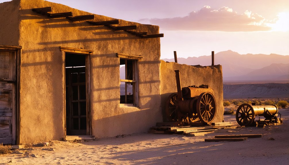
Aerial drone photography uniquely reveals the complex historical layers embedded within America’s ghost towns, from the skeletal remains of Rhyolite’s grand facades to the accumulated mining detritus at Gold King Mine.
Your drone’s perspective will uncover architectural details and historical context impossible to capture from ground level.
- Castle Dome’s intact mining structures tell the story of Arizona’s industrial past against the desert landscape
- Vulture City’s restored buildings showcase the evolution from bank to brothel in frontier settlements
- Gold King Mine’s rusting artifacts create a timeline of technological evolution in Jerome
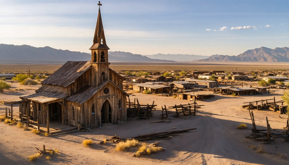
- Grafton’s cinematic legacy emerges through aerial views of buildings featured in classic Western films
- Rhyolite’s ambitious architecture reveals the brief but spectacular wealth of Nevada’s gold rush era
Safety Tips for Flying in Remote Desert Locations
While remote desert ghost towns offer compelling opportunities for drone photography, pilots must carefully navigate extreme environmental conditions and regulatory requirements unique to these isolated locations.
You’ll need to check TFRs before each flight, as wildfires frequently restrict access in summer months. With temperatures soaring above 110°F and minimal rainfall, your drone’s hardware faces significant stress.
Desert drone flights require vigilant monitoring of TFRs and hardware protection against extreme heat conditions exceeding 110°F.
Launch at least 328 feet from wildlife, and maintain vigilance during peak bird migration periods from March-April and August-November.
Before flying, download offline wilderness maps to identify no-fly zones, and use LAANC when necessary for controlled airspace access.
In uncontrolled Class G airspace, you’re free to operate within Part 107 limits, but harsh desert conditions demand environmental awareness and thorough pre-flight preparation.
Preserving History Through Aerial Documentation
Through systematic drone documentation, you’ll play an essential role in preserving America’s vanishing ghost towns for future generations.
Aerial preservation requires careful planning and adherence to legal requirements, while historical documentation demands precise technical execution to capture these remnants of the past.
- Use photogrammetric workflows with 70-80% forward overlap to create detailed 3D models and orthomosaics
- Secure necessary permits from BLM, NPS, or private landowners before conducting any flights
- Deploy ground control points for centimeter-level accuracy in your preservation mapping
- Capture both RGB and multispectral imagery to reveal hidden archaeological features
- Follow data management protocols including metadata tagging and secure backups
Frequently Asked Questions
How Do You Deal With Rattlesnakes While Setting up Drone Equipment?
You’ll need high boots, snake gaiters, and a clear setup zone. Inspect the area with long tools, keep gear elevated, maintain safe distances from rock piles, and have a snakebite kit ready.
Which Ghost Towns Have the Best Preserved Interior Spaces for Through-Window Shots?
You’ll find the most pristine abandoned buildings with historical significance at Bodie and Rhyolite, where desert conditions preserved authentic interiors perfectly for your through-window drone shots and detailed architectural captures.
Are There Local Drone Pilots Who Offer Guided Ghost Town Tours?
Like moths to a flame, local guides at Goldfield pair with Fox 10’s drone pilots for photography workshops, while you’ll find independent operators offering aerial tours at Vulture City and Cerro Gordo.
What Type of Insurance Covers Drone Damage From Abandoned Mine Gases?
You’ll need Hull Insurance with a Pollution/Contamination Extension to protect your drone from mine gases. Don’t rely on standard liability coverage – it won’t cover your equipment’s physical damage around hazardous sites.
How Do You Handle Curious Wildlife Approaching Drones During Filming?
If wildlife approaches your drone, climb slowly to a higher altitude, retreat steadily without sudden movements, and monitor their behavior. If distress signs persist, land immediately and switch to ground-based photography.
References
- https://pamphotography.blog/2023/05/22/photographing-four-ghost-towns-in-arizona/
- https://www.airvuz.com/video/Cerro-Gordo-Ghost-Town?id=5d08a204154be13ae9e52aec
- https://www.lerrophotography.com/colorado-fall-colors-and-ghost-towns/
- https://www.youtube.com/watch?v=9bMnLKogtto
- https://blog.annemckinnell.com/2014/05/08/light-painting-ghost-town/
- https://www.youtube.com/watch?v=Tbb3ynHDsI0
- https://www.youtube.com/watch?v=-er4dnYAXo8
- https://www.youtube.com/watch?v=mgBEQbnaT6A
- https://www.dronepilotgroundschool.com/drones-private-property/
- https://pilotinstitute.com/drones-in-national-parks/


