
You’ll find Nebraska’s most fascinating ghost towns scattered across the Sandhills and along pioneer trails, where over 900 abandoned settlements await exploration. Must-visit sites include Antioch, the former potash capital with visible foundations and graded streets, and historic Pischelville with its preserved lodge hall. Don’t miss Dobytown’s remnants near Fort Kearny or DeWitty’s African American pioneer heritage. These forgotten communities hold countless stories of frontier life, mining booms, and railroad dreams just waiting to be discovered.
Key Takeaways
- Antioch offers extensive ruins from its World War I potash production era, with visible foundations and graded streets still remaining.
- Dobytown, near Fort Kearny, features historical significance as a frontier trading post known for its saloons and military connections.
- Pischelville preserves frontier history through its National Register-listed lodge hall and operated blacksmith shop until 1954.
- Ardmore maintains visible remnants of frontier life with its boarded-up stores and historic post office building.
- DeWitty stands out as a historically significant African American settlement from the early 1900s with documented cultural heritage.
Exploring Nebraska’s Hidden Past: A Traveler’s Guide
While Nebraska’s ghost towns may seem lost to time, dedicated explorers can uncover these forgotten settlements through various discovery methods.
You’ll find settlement patterns emerge by comparing historic maps with current railroad routes, while aerial photographs reveal hidden foundations and old roadbeds beneath the prairie grass. County histories and newspapers reveal cultural legacies of these abandoned communities.
Faded maps and aerial views unveil ghost towns’ secrets, while local archives whisper stories of Nebraska’s vanished settlements.
You can spot railroad ghost towns by their distinctive graded streets and settler-planted trees, often marked by isolated grain elevators that stand at odd angles to modern county roads. The dramatic story of potash production collapse in Antioch exemplifies how quickly a booming town can vanish.
River settlements cluster near historic fords and ferry crossings, though floods have erased most physical traces. If you’re tracking speculative settlements, look for surviving tree groves and cemeteries – these ambitious developments now exist primarily in old maps and local legends. The Nebraska State Historical Society helps preserve these vital pieces of prairie heritage.
Historical Significance of Nebraska Ghost Towns
Nebraska’s ghost towns stand as silent witnesses to the state’s dynamic settlement patterns, with over 900 abandoned communities documented by the late 1960s.
Unlike the sudden desertion seen in mining states, these towns faded gradually as economic decline reshaped rural landscapes.
You’ll find rich cultural heritage in places like Pischelville, where a blacksmith shop operated until 1954, and the Bohemian National Cemetery’s artistic grave markers tell stories of early settlers. In Knox County, many businesses served as vital community hubs, with stores like Venus Store operating continuously for 100 years.
Railroad-dependent towns like Factoryville and Steele City thrived briefly before transportation shifts altered their destinies. The global crisis of 1857 devastated many promising settlements, forcing numerous railroad companies into bankruptcy.
Military outposts like Dobytown, which once supported 500,000 westbound travelers, vanished when Fort Kearny closed.
Today, these forgotten places survive mainly as names in old records and weathered tombstones, preserving chapters of Nebraska’s pioneering spirit.
Must-Visit Abandoned Settlements in the Sandhills
Among the haunting remains of Nebraska’s Sandhills, you’ll discover remarkable archaeological treasures spanning over 13,000 years of human habitation.
Artifacts like stone tools, arrow points, and hide scrapers reveal systematic tribal surveys conducted across massive ranch properties.
Near Mullen, you can explore a mid-1600s Plains Apache village where dome-shaped houses once stood, while the McIntosh Site reveals an ancient Indigenous heritage of hunting and farming from 2,000 years ago.
The Snake River region holds secrets beneath shifting dunes, preserving cultural significance through artifacts and tools from countless generations.
Early inhabitants relied on Clovis spear points to hunt mammoths and other large game animals.
Don’t miss DeWitty, a representation of African American pioneers who carved out a community in the early 1900s.
While many sites remain hidden beneath sand and grass, modern technology like ground-penetrating radar continues to disclose new discoveries, making the Sandhills an ever-evolving window into Nebraska’s past.
Trading Posts and River Towns: Lost Communities
Many trading posts that once served as bustling commercial hubs, like Fort Charles established in 1795, now stand as ghostly reminders of Nebraska’s early settlement period. The fort’s strategic location near the Omaha village made it an important center for fur trading with Native Americans.
Pioneer Trail Ghost Towns and Early Settlements
You’ll find the remains of Nebraska’s pioneer trail settlements scattered across the landscape, from Fort Kearny’s military outpost to Dobytown’s once-bustling commercial district.
The harsh realities of frontier life shaped these communities, where early settlers faced isolation, weather extremes, and economic uncertainty in trading posts and mining operations. Many communities followed Lewis & Clark and Mormon Trails, which later became part of the historic Wabash railway network. Lawless gunfights and gambling were commonplace in towns like Covington, where riverboat workers sought entertainment after dark.
Transportation developments, particularly the railroad’s expansion, determined many towns’ fates, as seen in Factoryville’s flour mill economy and Belmont’s rock tunnel settlement, which flourished briefly before becoming ghost towns when rail routes changed.
Settlement Life Challenges
Life on Nebraska’s frontier settlements presented pioneers with an unforgiving gauntlet of environmental, agricultural, and infrastructural challenges that would ultimately lead many communities to become ghost towns.
You’d have faced devastating settlement hardships like severe droughts, brutal blizzards, and destructive grasshopper plagues that decimated crops.
Agricultural struggles intensified as you attempted to farm with inferior equipment on isolated 160-acre plots, breaking tough prairie sod with oxen-powered tools.
Without timber, you’d have built sod houses on treeless plains, struggling against nature’s extremes.
Early frosts killed crops before harvest, while spring thaws turned the ground to impassable gumbo.
Poor transportation and limited access to basic resources like water made survival even more precarious, especially in communities bypassed by railroads.
Transportation Hub Remains
Throughout Nebraska’s pioneer era, a sprawling network of transportation hubs emerged as essential lifelines for westward expansion, leaving behind haunting remnants that tell their stories today.
You’ll find these railroad remnants scattered across towns like Crawford, which began as a tent city in 1886, and Harrison, where the historic Harrison House Hotel still stands at Nebraska’s highest elevation.
As you explore transportation history, you’ll discover ghost towns like Glen and Andrews that vanished when rail operations shifted.
Loading docks and retired cabooses mark where bustling depots once thrived. These silent sentinels of commerce connect you to an era when Missouri River towns served as crucial “jumping off places,” and landmarks like Courthouse Rock and Chimney Rock guided countless pioneers toward their dreams of western opportunity.
Mining and Trade Centers
While Nebraska’s early settlers sought their fortunes through various means, distinct ghost towns emerged around three main industries – flour milling, potash mining, and frontier trade.
You’ll find Factoryville and Glenwood’s remnants, where flour mills once powered local economies, with Glenwood Blue Mills producing 50 barrels daily.
In Antioch, Nebraska’s “potash capital,” you can explore the abandoned mining operations that boomed during World War I.
Trading posts and supply centers dotted the landscape, from Dobytown’s saloons serving Fort Kearny soldiers to Ingham’s mercantile stores supporting dryland farmers.
These historical industries shaped communities like Pischelville, where a blacksmith shop operated until 1954, and Minersville, which thrived during its mining heyday south of Nebraska City.
Mining Heritage: Forgotten Boomtowns
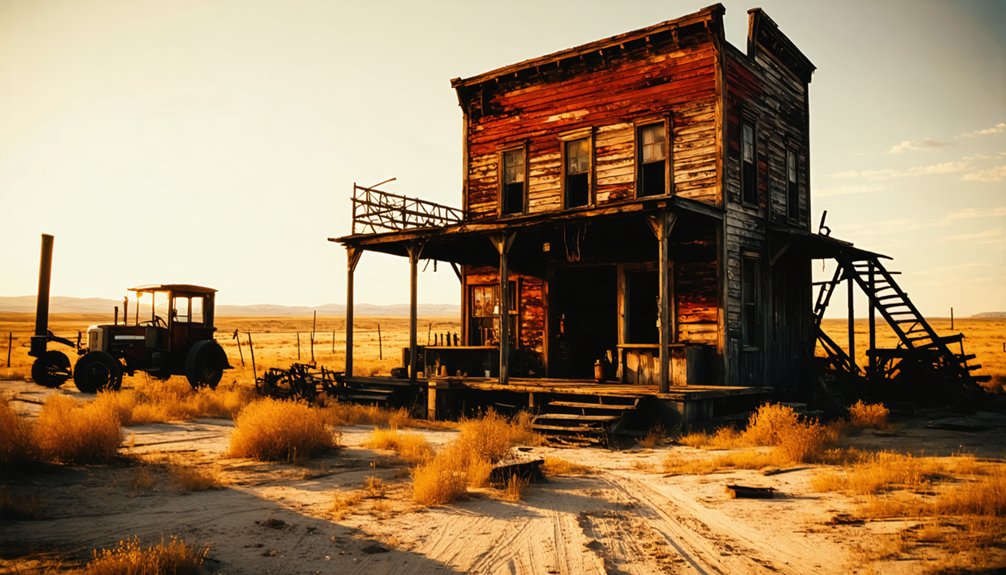
You’ll find Nebraska’s most prominent mining ghost town in Antioch, where potash extraction boomed during World War I to meet critical military demands.
The town’s strategic location 15 miles east of Alliance on Highway 2 made it an ideal hub for mining operations, earning it the title “potash capital of Nebraska.”
What remains today are visible foundations, graded streets lined with settler-planted trees, and other architectural remnants that tell the story of Nebraska’s brief but significant mining heritage.
Mining Claims and Settlements
Despite Nebraska’s limited mining heritage, several notable ghost towns emerged from mineral-related ventures in the late 1800s and early 1900s. You’ll find fascinating mining history in places like Antioch, where potash extraction drove wartime development during WWI, and Oreapolis, which began as an ambitious mining settlement at the junction of the Platte and Missouri Rivers.
The settlement dynamics varied across these forgotten boomtowns. While Minersville thrived briefly near Nebraska City with its mining operations and support structures, Oreapolis never fulfilled its grand vision as “Border City.”
In Knox County, communities grew around mills and mining activities, experiencing gradual decline rather than sudden abandonment. These sites offer glimpses into Nebraska’s brief but significant mineral extraction era, when settlers gambled their futures on promising claims that ultimately proved unsustainable.
Ore Discovery and Development
Nebraska’s ore discoveries sparked a series of mining booms that shaped the state’s early development.
You’ll find evidence of this heritage in the calcareous diatomite deposits that early settlers mistook for chalk, first mined in 1872 by Wisconsin pioneers in the North Loup Valley. The state’s diverse mineral resources attracted significant industrial development throughout the 1850s, with high-quality stone, coal, iron ore, and limestone driving the expansion.
During World War I, potash extraction created new opportunities for mineral resources across Nebraska’s communities.
You can trace the growth of these operations through the infrastructure they left behind – from elaborate tunnel systems carved through solid rock to the remnants of railroad depots and mining facilities.
These operations determined settlement patterns and transformed Nebraska’s landscape until economic shifts and resource depletion led to their abandonment.
Ghost Mine Remnants Today
Today’s scattered ruins of abandoned mining settlements tell a compelling story of Nebraska’s resource-driven past.
You’ll find Antioch’s potash legacy 15 miles east of Alliance, where ghost town legends whisper of World War I’s mining frenzy. At Minersville, south of Nebraska City, dense overgrowth now shrouds the few remaining structures, adding to the region’s mining folklore.
The stone remnants of Belmont Tunnel stand as a symbol of railroad ambitions, while Oreapolis’ grand plans for iron and coal extraction survive only in yellowed prospectuses.
Perhaps most haunting is Alkali, where white mineral deposits mark nature’s rejection of human settlement.
These sites aren’t just relics – they’re living museums where you can trace the boom-and-bust cycles that shaped Nebraska’s landscape.
Preserved Structures and Architectural Remnants
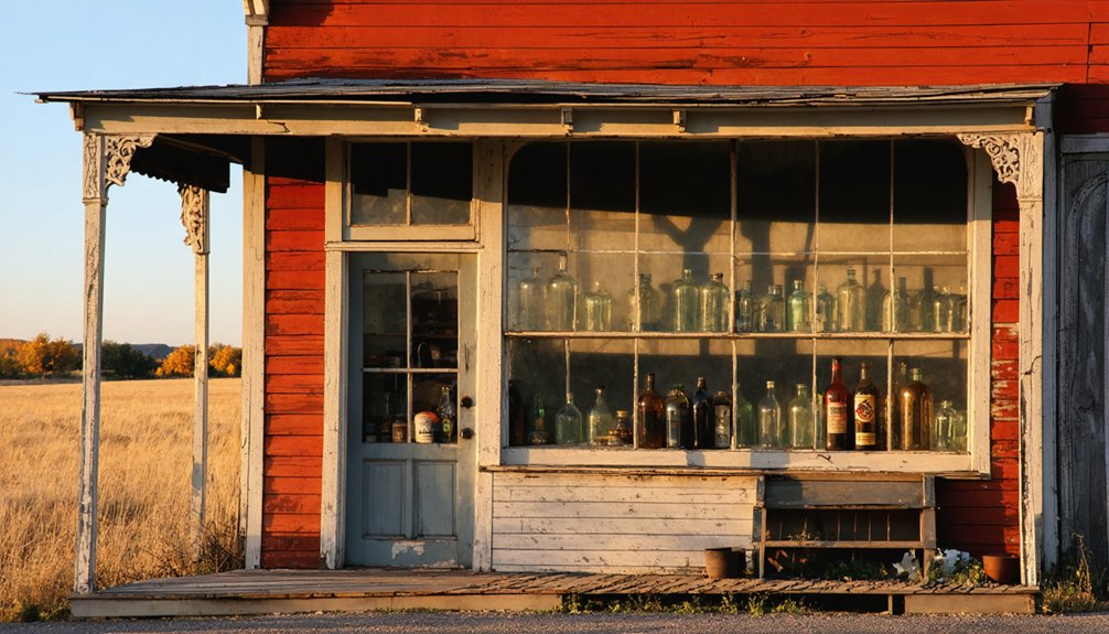
Throughout Nebraska’s abandoned settlements, remarkable architectural remnants stand as symbols to frontier life, from Pischelville’s historic 1884 lodge hall to Belmont’s carved railroad tunnel.
You’ll find diverse architectural styles preserved across these ghost towns, from wooden structures to solid brick buildings. In Ardmore, you can explore boarded-up stores and the old post office that remain structurally sound despite their weathered exteriors.
Montrose’s one-room schoolhouse and church showcase frontier institutional architecture, while railroad ghost towns feature impressive grain elevators along abandoned rail lines.
Preservation efforts have protected significant structures like Pischelville hall, now listed in the National Register of Historic Places. The Bohemian National Cemetery’s artistic grave markers and Belmont’s stone tunnel mouth continue drawing photographers and history enthusiasts seeking authentic frontier artifacts.
Planning Your Nebraska Ghost Town Road Trip
Ready to explore Nebraska’s forgotten settlements? Plan your ghost town photography adventure along the Nebraska Outlaw Trail Scenic Byway (Highway 12) and Highway 137, where abandoned buildings and rural landscapes await.
You’ll need at least 12 hours of drive time to explore these remote locations.
- Start at Antioch in the sandhills, then wind through the rolling hills to Brocksburg.
- Visit St. Deroin’s visible ruins near Indian Cave State Park.
- Explore Sparks’ historic post office and church, both standing since 1888.
- Photograph the remaining structures in Minersville and Meadville.
Consider splitting the journey into two days for thorough exploration.
Take your time exploring these historic sites – a two-day trip allows for deeper discovery and better photos.
Watch for route challenges on dirt roads, especially near Highway 137. Winter weather can impact accessibility, so check conditions before departing.
For the best experience, bring GPS or printed directions to navigate the remote county roads efficiently.
Photography Tips for Capturing Abandoned Places
Once you’ve mapped out your ghost town expedition, mastering the right photography techniques will help you capture the haunting beauty of these abandoned places.
For stunning abandoned photography, use HDR exposure techniques to reveal details in high-contrast scenes. Set up your tripod for long exposures at f/8 with shutter speeds around 30 seconds to balance ambient window light with darker interiors.
Shoot during early morning or late afternoon when angled sunlight creates dramatic natural effects through broken windows and ceilings. Try low-angle shots and diagonal perspectives to emphasize architectural scale and create intrigue.
Focus on weathered details, rust patterns, and nature’s reclamation of manmade structures. For night shoots, experiment with light painting to illuminate buildings while capturing starlit skies.
Remember to desaturate your images slightly to enhance the contemplative atmosphere of these forgotten places.
Frequently Asked Questions
Are Any Nebraska Ghost Towns Reportedly Haunted by Spirits?
You’ll find haunted legends throughout Nebraska’s ghost towns, with ghost stories of restless spirits near Seven Sisters Road, Devil’s Canyon, Witch’s Bridge, and Ball Cemetery still frightening locals today.
Can Visitors Legally Take Artifacts Found in Ghost Towns?
You can’t legally pocket that rusty smartphone – I mean artifact – from ghost towns. Artifact preservation laws prohibit removal from public lands, and you’ll need written permission on private property.
Which Ghost Towns Are Accessible During Winter Months?
You’ll find all four ghost towns accessible in winter. Brocksburg and Venus via dirt roads, St. Deroin through Indian Cave State Park, and Monowi’s maintained roads offer year-round exploration despite harsh conditions.
Are There Guided Tours Available to Any Ghost Towns?
Time waits for no one, and you’ll find no official guided tour options to Nebraska’s ghost towns. You’re free to explore Venus, Wee Town, and Ames independently, respecting their historical significance.
Do Any Ghost Towns Still Have Active Private Property Owners?
You’ll find active ownership still exists in many ghost towns, with property rights firmly held by private landowners who control access to historic sites and maintain residences like Monowi’s sole inhabitant.
References
- https://history.nebraska.gov/wp-content/uploads/2017/12/doc_publications_NH1937GhostTowns.pdf
- https://www.onlyinyourstate.com/trip-ideas/nebraska/ne-ghost-towns-road-trip
- https://kids.kiddle.co/List_of_ghost_towns_in_Nebraska
- https://history.nebraska.gov/finding-nebraskas-ghost-towns/
- https://www.geotab.com/ghost-towns/
- https://visitnebraska.com/trip-idea/explore-7-authentic-ghost-towns-nebraska
- https://map.proxi.co/r/hr_MiilsN6m2Pvftj-5a
- https://www.oocities.org/dustinmdudley/nebraska_map.html
- https://omahalibrary.contentdm.oclc.org/digital/collection/p16747coll4/id/1391/
- https://en.wikipedia.org/wiki/List_of_ghost_towns_in_Nebraska


