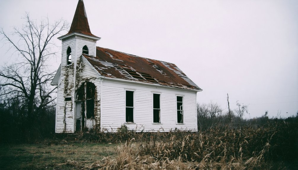
You’ll find Blanche nestled in northeastern Cherokee County’s Appalachian foothills, where a vibrant 19th-century farming settlement once thrived at 709 feet above sea level. The community emerged around local churches, schools, and a general store, with families cultivating diverse crops and cotton on varied terrain. Though officially recognized with a post office in 1883, Blanche couldn’t sustain growth without major industries or rail connections. Today’s scattered foundations and overgrown paths hold countless untold stories of this Alabama ghost town.
Key Takeaways
- Blanche was established in Alabama’s Cherokee County during the 19th century, receiving official recognition with a post office in 1883.
- The settlement’s development was linked to James Whitfield Balkum in the 1870s but lacked major industries or rail connections.
- Located at 34.3634232°N and -85.6099634°W in northeastern Alabama, the site sits 709 feet above sea level in Appalachian foothills.
- The community relied on farming, with diverse agricultural practices including cotton cultivation and livestock raising for economic sustainability.
- Today, the abandoned site features scattered foundations and debris, largely reclaimed by nature and accessible only through private property.
The Origins of Blanche Settlement
While historical records remain limited, Blanche emerged as a settlement in Alabama during the 19th century, joining numerous other small communities that dotted the state’s landscape during this period of rapid expansion.
Like many of its neighboring towns, you’ll find that Blanche’s roots were deeply tied to agricultural pursuits and the promise of economic opportunity.
Settlement myths suggest that founding families were drawn to the area’s fertile soil and strategic location, though the exact details of their arrival have been lost to time.
The Alabama Archives and History serves as a valuable resource for uncovering fragments of information about the settlement’s early days.
As you explore the town’s origins, you’ll discover that it was likely established as part of Alabama’s broader pattern of rural development, where small communities formed around shared resources and the need for local commerce and social gathering spaces. Much like the town of Cahaba in 1819, Alabama’s settlements were often strategically positioned to take advantage of economic and political opportunities.
Geographic Location and Natural Features
Nestled in the northeastern reaches of Alabama, Blanche occupies a distinctive position at 34.3634232°N and -85.6099634°W in Cherokee County. Like many ghost towns across America, it stands as a testament to the region’s bygone era.
You’ll find this ghost town perched at 709 feet above sea level, surrounded by the rolling terrain of the Appalachian foothills. The area’s geological features include moderately hilly landscapes dotted with mixed hardwood forests of oak, hickory, and pine.
The site’s precise location in decimal degree coordinates allows for accurate mapping and navigation of the area. While no major rivers flow directly through Blanche, you’ll discover small seasonal streams that contribute to the Tennessee River watershed.
The town’s ecological diversity stems from its unique position in the foothills, where forest meets stream, creating natural corridors for wildlife.
Though off the beaten path, you can reach Blanche through rural routes near Gaylesville, where the rugged terrain tells stories of early settlers who carved out their lives in these hills.
Historical Development and Regional Context
During Blanche’s early development in the late 19th century, you’ll find its origins tied closely to James Whitfield Balkum’s arrival at the crossroads near Abbeville-Columbia and Newton-Franklin in the 1870s.
Your understanding of the settlement’s growth would center on the establishment of its post office in 1883, which marked Blanche’s official recognition as a community.
You’ll notice that unlike many successful Alabama towns of the era, Blanche lacked major industries or rail connections that could have sustained long-term development. Like many similar communities documented in Dead Towns of Alabama, Blanche experienced a dramatic population decline that led to its eventual abandonment.
Similar to the historic town of Cahawba, nature reclaimed the abandoned buildings and streets of Blanche over time.
Early Settlement Patterns
As Native American tribes shaped the landscape of what would become Blanche, Alabama, European explorers like Hernando de Soto began traversing the Southeast in the colonial era, forever changing the region’s settlement patterns.
You’ll find that early settlers were drawn to the area’s fertile soil, establishing homesteads where cultural exchange between Native Americans and Europeans influenced farming techniques and community development.
The region’s growth accelerated after the American Revolution, when treaties and land cessions opened new territories for settlement.
You’d have seen communities forming around shared resources, with churches and schools becoming essential gathering places. Located at N34 21.813′, W85 36.592′, the settlement developed into a notable populated place in Cherokee County.
Agricultural practices evolved as settlers adapted traditional European methods to local conditions, while incorporating successful Native American farming techniques.
Much like Cahawba’s flooding issues that led to its abandonment as state capital, the development of transportation routes, including rivers and primitive roads, connected these emerging settlements, fostering trade and strengthening community bonds.
Cherokee County Influences
Cherokee County’s vibrant development played a defining role in Blanche’s history, with the establishment of Jefferson (later Cedar Bluff) marking a key chapter in the region’s growth.
Steam engine powered mills by Capt. Joel Thorp and Maj. Pauline Meidjzelski introduced industrial innovation to the region.
The area’s Cherokee heritage shaped early settlement patterns, while the county’s position on Georgia’s border created unique cultural impact through trade and migration.
The county’s iron ore production became especially vital during the Civil War when Cornwall Furnace supplied materials for Confederate forces.
You’ll find these pivotal developments shaped the region:
- The first steam-operated mills in North Alabama revolutionized local industry.
- The county seat’s move from Cedar Bluff to Centre in 1844 shifted economic power.
- The creation of Weiss Lake in 1961 transformed the region’s recreational potential.
Life in Early Blanche Community
Given the scarce historical records of Blanche, you’ll find little documented evidence of early community life in this Cherokee County settlement.
While nearby Alabama ghost towns often featured common rural activities like crop cultivation and livestock raising, specific details about Blanche’s farming practices and social gatherings remain undocumented.
The settlement’s transportation networks and connections to neighboring communities also lack historical verification, though its coordinates place it within the broader context of rural Alabama development.
Rural Farming Practices
While Native American influences shaped early agriculture in Blanche, settlers quickly developed their own distinctive farming practices that defined the community’s character. They embraced sustainable agriculture through crop rotation and the traditional Three Sisters method – planting corn, beans, and squash together to maximize soil health and yields.
Life on Blanche’s farms revolved around three essential activities:
- Growing staple crops like corn for both family consumption and livestock feed
- Maintaining open-range cattle grazing in the less fertile areas
- Operating small cotton plots where soil conditions allowed
You’d find most farmers adapting to the region’s varied soil conditions, with those in sandier areas focusing more on livestock while others worked smaller, diversified plots.
This practical approach helped families maintain their independence and self-sufficiency despite challenging conditions.
Community Social Gatherings
Vibrant social gatherings formed the heartbeat of early Blanche, with churches and schoolhouses serving as the primary venues for community life. You’d find families coming together for Sunday services, followed by shared meals that strengthened neighborly bonds.
Social interactions flourished through seasonal festivals, barn raisings, and quilting bees, where townspeople supported one another while building lasting relationships.
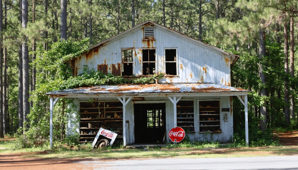
Community activities centered around the local schoolhouse, where you could join spelling bees, theatrical performances, and lively dances. The general store buzzed with daily news exchanges, while extended families maintained tight-knit support networks through regular visiting and hospitality.
During leisure time, you’d participate in hunting expeditions, community picnics, and musical gatherings where storytelling and folk traditions kept the town’s cultural heritage alive.
Early Transportation Networks
The Old Federal Road anchored Blanche’s early transportation network, serving as a vital east-west artery that connected the settlement to broader territorial routes after 1805.
You’d find transportation challenges that shaped daily life, from unpaved paths that turned treacherous in wet weather to the limitations of mule-drawn wagons for hauling goods and supplies.
Key aspects of Blanche’s transportation system included:
- Local roads following ancient indigenous trails and ridgeways
- Chert-stabilized surfaces requiring constant road maintenance by county workers
- Intersection with Gaines Road, connecting military outposts and mail routes
Despite these challenges, you could rely on horseback travel and wagon transport to reach regional markets, though weather often dictated your journey’s success through the rugged Alabama terrain.
Economic Rise and Decline
Situated at the strategic confluence of the Alabama and Cahaba rivers, Cahawba’s economic journey began in 1819 as Alabama’s first state capital.
Cahawba rose from the meeting point of two mighty rivers, marking its historic beginning as Alabama’s pioneering capital city.
You’ll find the town’s early economic resilience reflected in its bustling cotton trade, with merchants shipping thousands of bales downriver to Mobile. The arrival of a railroad in 1859 sparked remarkable community transformation, helping the population grow to over 3,000.
The Civil War struck a devastating blow when Union forces blockaded Mobile, halting cotton exports. The conversion of warehouses into prison camps and the catastrophic flood of 1865 dealt further setbacks.
You’ll see how Cahawba’s fortunes dwindled after losing its county seat status to Selma in 1866. Despite brief agricultural revival during Reconstruction, the town’s economy never recovered, leading to its ultimate unincorporation in 1989.
Notable Structures and Landmarks
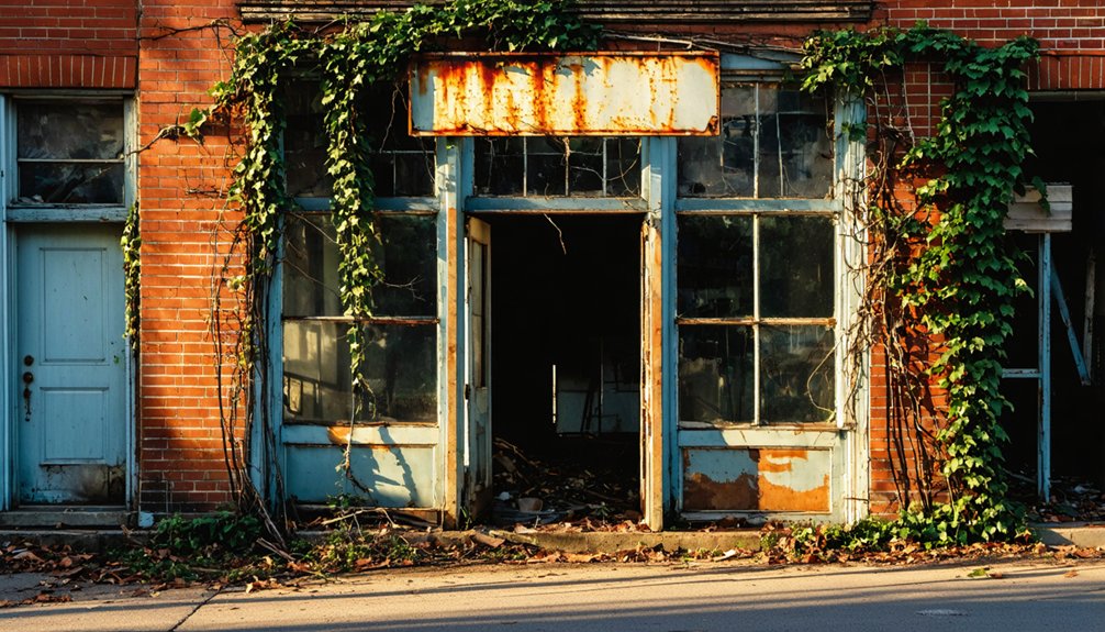
Standing as silent witnesses to Cahawba’s former glory, the town’s architectural remains offer visitors a haunting glimpse into Alabama’s first capital city.
While most original structures succumbed to fire and decay by 1900, you’ll still find compelling traces of historical significance throughout the site.
Three must-see landmarks that tell Cahawba’s story:
- St. Luke’s Church, which continues to host family gatherings and serves as a symbol of community resilience
- The African-American Methodist church ruins, featuring distinctive brick columns and cement pedestals that speak to post-Civil War freedom
- Victorian-era cemeteries, where ornate wrought iron fencing and detailed tombstones preserve the artistry of 19th-century craftsmen
You can explore several preserved residential structures, peering through time into the daily lives of Cahawba’s former inhabitants.
Local Legends and Stories
Beyond its physical remains, Blanche’s most enduring legacy lives in the dark tales and ghostly legends passed down through generations of Alabama locals.
You’ll hear whispers of vengeful spirits tied to accused witches who met violent ends, their restless souls said to manifest as mysterious bumps in local roads.
The town’s haunted history features spectral orbs, unexplained voices, and translucent figures that drift near abandoned buildings.
Civil War soldiers still patrol their posts, while wronged families seek justice from beyond the grave.
If you’re brave enough to visit, locals warn you might encounter cold spots or phantom footsteps – remnants of a community whose tragic decline birthed countless supernatural stories of curses, revenge, and unfinished business.
Present-Day Status and Preservation
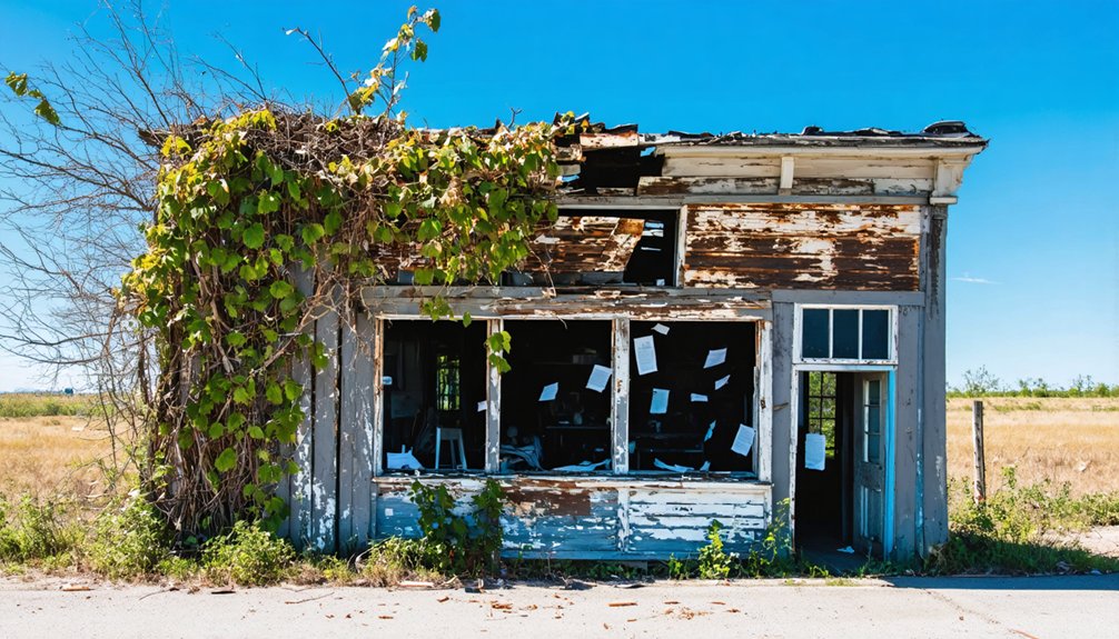
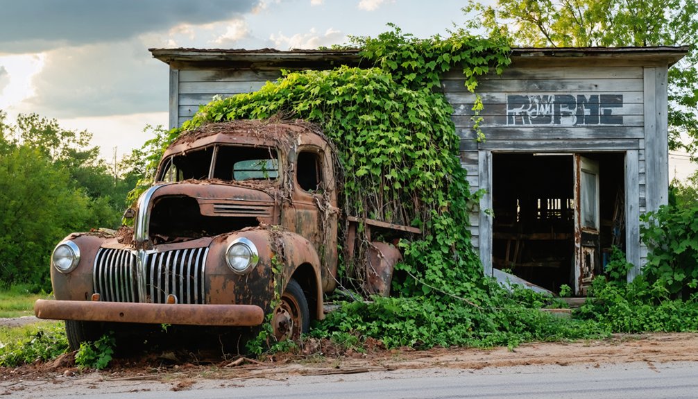
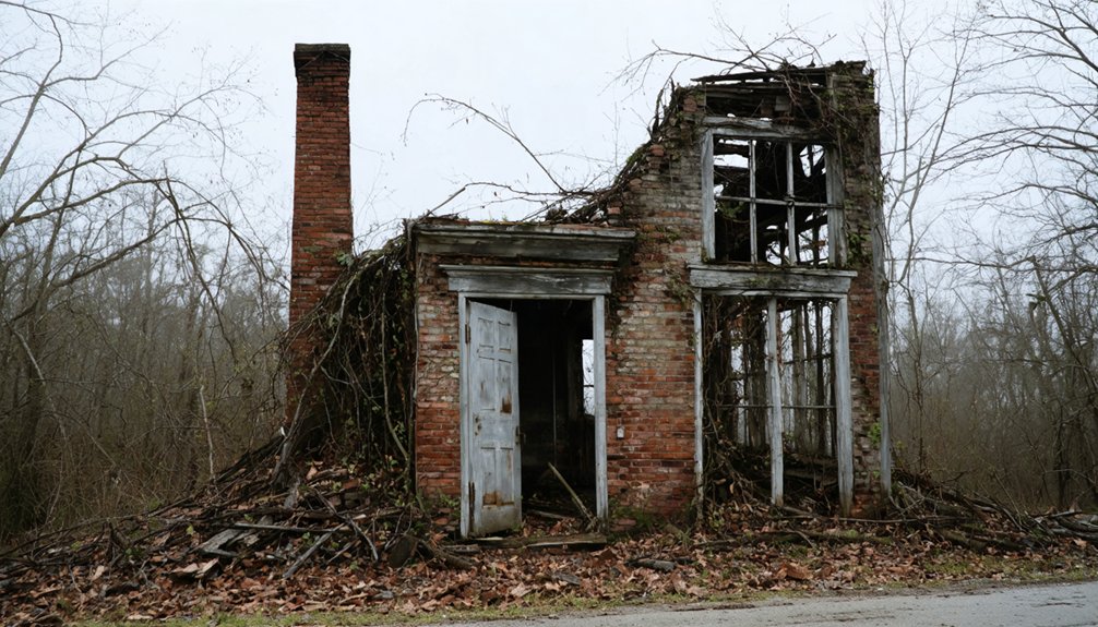
While time has erased most traces of Blanche’s former existence, today’s ghost town site reveals little more than scattered foundations and debris amid encroaching Alabama wilderness.
The current condition reflects decades of abandonment, with nature steadily reclaiming what was once a bustling community.
If you’re planning to explore Blanche, you’ll face several preservation challenges:
- Private land ownership limits public access, with no formal visitation infrastructure
- Natural overgrowth and seasonal vegetation make site navigation difficult
- Lack of historical protection leaves remaining artifacts vulnerable to further deterioration
Without official recognition or preservation efforts, Blanche exists primarily in historical records rather than physical form.
The site stands as a reflection of Alabama’s evolving landscape, where ghost towns quietly fade into the natural environment, their stories preserved mainly through documentation and local memory.
Visiting the Ghost Town Site
For those seeking to explore Alabama’s forgotten past, Blanche ghost town offers a remote yet accessible destination in Cherokee County at coordinates N34 21.813′, W85 36.592′.
You’ll need your own vehicle to reach this rural attraction, as the site sits amid the quiet countryside typical of northern Alabama.
While there aren’t organized tours, ghost town exploration here provides a genuine opportunity to connect with the region’s history at your own pace.
Remember to approach any remaining structures with caution and respect for private property.
The surrounding natural landscape offers excellent photography opportunities, particularly during spring and fall.
You’ll find accommodations in nearby towns, and local communities might share valuable insights about Blanche’s past.
Consider combining your visit with trips to other historical sites in Cherokee County.
Frequently Asked Questions
What Role Did Native Americans Play in the Early History of Blanche?
You’ll find Native tribes were integral to the area’s development, engaging in cultural exchange with early settlers through trade networks and sharing agricultural knowledge of the region’s fertile lands.
Were There Any Significant Epidemics or Disasters That Affected Blanche?
While you’d expect dramatic tales of epidemic outbreaks and disaster response in Blanche’s decline, there’s no historical evidence of any significant health crises or natural catastrophes affecting this small Alabama community.
What Types of Crops Were Primarily Grown by Blanche’s Farming Community?
You’d find cotton production dominated the farmland, with farmers practicing limited crop rotation using corn, beans, and squash. They’d also grow subsistence crops like okra and black-eyed peas for local consumption.
Did Any Famous Personalities or Historical Figures Visit Blanche?
Like footprints washed away by time, you won’t find records of any famous visitors or historical figures stopping in Blanche. No documented evidence exists of notable personalities visiting this small community.
How Did the American Civil War Impact the Development of Blanche?
You’ll find the Civil War devastated Blanche’s growth through economic impact, destroying farmland and infrastructure, while the loss of enslaved labor and returning soldiers created lasting hardships for your community’s survival.
References
- https://www.youtube.com/watch?v=d-Tuy6jw6TQ
- https://ahc.alabama.gov/properties/cahawba/cahawba.aspx
- https://www.blueridgeoutdoors.com/go-outside/ghost-towns-of-old-cahawba/
- https://www.youtube.com/watch?v=NplH1TF86Ro
- https://digitalalabama.com/article/alabama-ghost-towns
- https://digitalalabama.com/alabama-ghost-towns/cherokee-county-alabama-ghost-towns/47511
- https://en.wikipedia.org/wiki/List_of_ghost_towns_in_Alabama
- https://www.youtube.com/watch?v=R7CbEhIOwnE
- https://wearehuntsville.com/old-cahawba-alabamas-capital-ghost-town/
- https://www.tageo.com/index-e-us-v-al-d-114481.htm