You’ll find Bluewater ghost town near New Mexico’s Continental Divide, where it once thrived as a railroad hub and agricultural center. Named for its distinctively blue waters, the town emerged in 1881 around an Atlantic and Pacific Railroad station. It gained fame as the “Carrot Capital of the World” and prospered along Route 66 until the 1950s. Environmental challenges, resource depletion, and economic shifts transformed this bustling community into a silent tribute to the American Southwest’s boom-and-bust heritage.
Key Takeaways
- Bluewater transformed from a thriving Route 66 town into a ghost town following the decline of uranium mining and failed agricultural ventures.
- Located at 6,749 feet elevation in Cibola National Forest, the abandoned town features remnants of its railroad station and trading post.
- The town’s economy collapsed in the late 1950s due to resource depletion and environmental contamination from uranium mining activities.
- Historic structures include Bowlin’s Old Crater Trading Post, Native American murals, and the iconic Bluewater Motel neon sign.
- Once known as the “Carrot Capital of the World,” Bluewater’s farmlands now lie fallow due to environmental degradation and economic decline.
The Blue Waters That Named a Town
The striking blue waters of Bluewater Creek and Bluewater Lake gave this New Mexico ghost town its distinctive name.
You’ll find these pristine waterways nestled in Cibola National Forest, where they’ve long sustained the region’s natural beauty and resources. The area’s unique geological and hydrological conditions create the water’s signature blue hue and quality. Located at an elevation of 6,749 feet, the town sits in an ideal position to access these remarkable water features.
Nestled within Cibola National Forest, these crystal-clear waters reflect nature’s brilliance through distinctive geological features and pristine conditions.
Originally called Mormontown, the settlement’s identity became so intertwined with its remarkable water features that locals renamed it Bluewater. The creek and lake have been crucial to the area’s development, providing essential irrigation and supporting a thriving freshwater ecosystem. These waters provide the only habitat for coldwater trout fishing in this arid region of New Mexico.
Today, ongoing ecological restoration efforts by the USDA Forest Service help preserve the watershed’s health, ensuring these iconic blue waters continue flowing through the high desert landscape.
Native Heritage and Early European Settlement
Long before European settlers arrived in what would become Bluewater, Native American peoples cultivated a rich agricultural society near the region’s water sources. Through native traditions and cultural memory, it’s understood that a lake existed in the valley over 3,000 years ago, before ancient lava flows shaped the landscape you see today. Built in 1954, Claude Bowlin’s trading post became a vital hub for preserving authentic Native American crafts and culture in the region. By the 1600s, the development of acequia systems helped indigenous peoples maintain their agricultural practices in the arid climate.
- The Navajo controlled these lands until the U.S. Army’s campaigns of the 1860s forced them out.
- Mimbreños Apaches faced violent encounters with settlers near mining areas.
- French homesteaders established the first European ranches along Bluewater Creek in the 1850s.
- Trading posts like Bowlin’s Old Crater later became crucial centers for preserving Native arts.
The Spanish first adopted the indigenous name, calling it “Agua Azul” for its clear waters, marking the beginning of European influence in this contested territory.
Railroad’s Arrival and Town Development
When Atlantic and Pacific Railroad constructed a station near Bluewater Creek in 1881, they sparked the town’s transformation from an isolated settlement into an essential transportation hub.
You’ll find the station’s name evolved from the Spanish “Agua Azul” to “Blue Water” and finally “Bluewater” by 1883. The railroad’s significance became evident as it enabled vital irrigation projects and facilitated the transport of agricultural goods and timber throughout the region. The railroad was critical for lumber operations, with the American Lumber Company establishing major logging and transport infrastructure in the area by 1903.
In 1905, Ernst A. Tietjen formally surveyed the townsite, leading to organized lot sales and community infrastructure development. The Santa Fe Railway had plans to utilize the area for coal development in later decades.
The railroad’s presence attracted businesses serving travelers, including motels, cafes, and gas stations. While Bluewater remained modest in size, its strategic location near the Continental Divide and Route 66 cemented its role in regional transportation.
Life Along Historic Route 66
Building upon Bluewater’s railroad foundation, Route 66 emerged as a transformative force in 1926, following what would become NM-122 west of Milan to Prewitt.
You’d find the golden age of Route 66 nostalgia in full swing after the road’s paving in the mid-1930s, with Bowlin’s Old Crater Trading Post becoming a must-stop destination by 1936. Early settlers faced challenges from periodic severe droughts that tested their resilience in the harsh desert environment. The trading post served as a vital community hub for the local Navajo population.
- You could marvel at the trading post’s iconic southwestern architecture, with its flat roof, stucco walls, and vibrant murals.
- You’d discover authentic Navajo rugs, jewelry, and pottery alongside tourist souvenirs.
- You’d fill up your tank at the newly added gas pumps while exploring unique roadside attractions.
- You’d experience the bustling mix of tourists, miners, and local Navajo commerce until I-40’s arrival changed everything.
Agricultural Dreams and Natural Disasters
As the Bluewater Land and Irrigation Company formed in 1894, ambitious plans for agricultural development took shape through the construction of a 400-acre reservoir and dam in Blue Water Canyon.
These early agricultural innovations transformed the landscape, but nature had other plans. In 1903, the dam partially failed, devastating homes, fields, and railroad infrastructure while bankrupting the company. Territorial Engineer Charles D. Miller attributed these structural issues to lack of expert supervision.
Despite irrigation challenges, you’d have witnessed remarkable resilience as the region became known as the “Carrot Capital of the World.” The discovery of rich uranium deposits in 1950 brought additional prosperity to the area.
Salvador Milan’s 1946 conversion of a sheep farm to truck farming exemplified this agricultural drive. Farmers adapted by drilling 600-foot wells when Bluewater Lake proved unreliable, and the fertile volcanic soil yielded abundant harvests.
During peak seasons, over 1,000 train cars transported carrots, peas, and lettuce from Grants to distant markets.
Town Planning and Street Layout
The distinct layout of Bluewater emerged from its strategic position along Route 66, marking a shift from pure agricultural roots to a hybrid highway town. The street design prioritized access to the main highway, with commercial structures grouped tightly along the frontage.
You’ll find spatial organization reflecting both necessity and opportunity, as Bluewater adapted to serve travelers while maintaining its agricultural character.
- Trading posts like Bowlin’s Old Crater became vibrant social hubs where locals and travelers mingled freely
- The 1957 Bluewater Motel & Inn represented modern freedom and mobility on the open road
- Allen’s Garage symbolized independence and self-reliance for highway adventurers
- Secondary dirt roads preserved the town’s connection to its farming heritage
The town’s layout evolved naturally, constrained by the Zuni Mountains and Bluewater Lake, creating an organic rather than rigid grid pattern.
The Economic Rise and Fall
You’ll find Bluewater’s initial economic surge closely tied to its strategic location near the railroad depot and its rich agricultural foundation supported by irrigation from Bluewater Creek.
The town’s prosperity expanded through farming success and later uranium mining activities, with Route 66’s arrival in 1926 further boosting its connectivity and trade potential.
The eventual decline of both agricultural productivity and mining operations, coupled with changing transportation patterns, led to Bluewater’s gradual transformation into a ghost town.
Railroad Sparks Town Growth
When Atlantic and Pacific Railroad established a station at Bluewater in 1881, they sparked the town’s transformation from scattered homesteads into a thriving commercial hub.
Initially named “Agua Azul,” the station quickly became a significant railroad infrastructure point connecting local ranches to broader markets.
You’ll find Bluewater’s economic dependencies were deeply tied to the railroad’s presence, which enabled:
- Massive carrot production earning the town its “Carrot Capital of the World” status
- Efficient lumber transport through local sawmill operations
- Coal mining development and resource extraction opportunities
- Important postal, supply, and passenger services
The railroad’s impact extended beyond mere transportation, fostering the construction of irrigation dams and establishing Bluewater as a key logistical center.
This rail connectivity positioned the town as an economic powerhouse in Valencia County, later becoming part of Cibola County.
Natural Resources Run Dry
Despite Bluewater’s initial prosperity from uranium mining, the town’s economic foundation began crumbling in the late 1950s as natural resources steadily depleted. You’d have witnessed the dramatic resource depletion firsthand, as the uranium mill’s production fluctuated wildly before reaching its peak capacity of 6,000 tons per day in 1978.
The ecological impact was devastating. Mining operations contaminated local soil and water, while acid and carbonate leaching left behind toxic tailings.
Bluewater Creek’s watershed deteriorated, affecting wildlife habitats and livestock operations. Even when ranching tried to replace mining as the economic backbone, the environmental damage had already taken its toll.
From Bustling Station to Silent Streets
Although Bluewater once thrived as a vibrant railroad hub, its transformation into a ghost town mirrors the fate of many Western settlements. The town’s decline wasn’t sudden but rather a series of setbacks that chipped away at its foundation.
Environmental impacts, including devastating floods and droughts, first struck the cattle industry in the 1880s and 1890s, forcing ranchers to abandon their herds.
Harsh climate swings in the late 1800s devastated Bluewater’s ranching economy, leaving cattlemen with no choice but abandonment.
- You can still see traces of cultural exchanges at the Old Crater Trading Post, where Navajo traders once gathered.
- The railroad station, once buzzing with activity, now stands as a silent reminder of bygone prosperity.
- Farmlands that earned Bluewater its “Carrot Capital” title lie fallow and forgotten.
- Even the uranium boom couldn’t sustain the town’s significance, leaving behind empty streets where miners once walked.
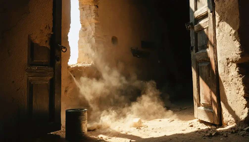
Exploring the Ghost Town Today
When you visit Bluewater’s ghost town today, you’ll find scattered ruins and remnants of buildings at the foot of the Zuni Mountains, accessible via local roads branching from Route 66.
You’ll need to carefully navigate the uneven terrain while exploring the decaying structures, as there’s minimal signage and no formal visitor infrastructure at the 6,749-foot elevation site.
Local ghost stories and legends of the Route 66 era add intrigue to your exploration, though you should respect private property boundaries and prepare for remote conditions with adequate supplies.
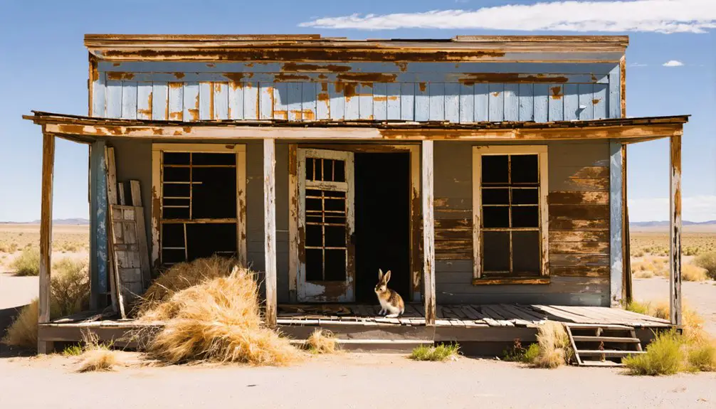
Visible Remnants and Ruins
Today’s visitors to Bluewater, New Mexico encounter a landscape dotted with remnants of mid-20th-century commerce and daily life.
You’ll find the classic neon sign of the Bluewater Motel still standing tall, a symbol of its 1957 origins when 22 modern units offered travelers air conditioning and wall-to-wall carpeting.
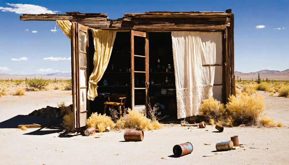
The historic Bowlin’s Old Crater Trading Post, dating back to 1936, showcases vibrant Native American murals among its ruins.
- Allen’s Garage foundations reveal the town’s role in serving Route 66 motorists since 1955
- The curved metal remains of Brock’s Trading Post Quonset hut reflect post-WWII ingenuity
- Original trading post structures tell stories of commerce in rugs, jewelry, and pottery
- Scattered foundations paint a picture of a once-thriving highway community
Route 66 Ghost Stories
Travelers exploring the ghostly remnants of Bluewater often report strange phenomena along this stretch of historic Route 66.
You’ll find tales of a vengeful phantom truck driver who haunts these haunted highways, while others describe unexplained noises echoing through abandoned buildings and trading posts.
The area’s most notable spectral sightings include vanishing vehicles and mysterious figures wandering through deteriorating structures like the old Bowlin’s Crater Trading Post.
The desolate backdrop of Bluewater’s decay, intensified by its abandonment after Interstate 40’s construction, creates an eerie atmosphere that continues to fuel paranormal encounters.
You might encounter reports of shaking bathroom stalls, unseen presences in empty buildings, or even stories of supernatural dog packs that chase visitors along this historic corridor.
Accessing the Ghost Town
Located on the western outskirts of Milan, New Mexico, Bluewater ghost town can be accessed by following Kelly Road to a local church, where you’ll need to continue on foot past a gate.
The site lies about 3.5 miles west of Toltec along old Route 66, with various access routes connecting from Grants and Gallup.
For the safest exploration of this remote site at 6,749 feet elevation, follow these visitor guidelines:
- Bring navigation tools – minimal signage means you’ll rely on maps or GPS
- Pack desert essentials – water, sun protection, and emergency supplies
- Wear sturdy hiking boots for the rugged, uneven terrain
- Inform someone of your plans before venturing into this isolated location
The area beyond the gate allows foot travel, but vehicle access is restricted in certain areas.
Frequently Asked Questions
Are There Any Dangerous Wild Animals in the Bluewater Ghost Town Area?
You’ll need to practice wildlife safety, as black bears and mountain lions inhabit the area. While animal encounters are rare and they typically avoid humans, these predators can be dangerous.
What Is the Nearest Modern Town With Amenities to Bluewater?
You’ll find Grants is your closest hub for modern amenities, just 10 miles southeast. This nearby town offers everything you need – groceries, fuel, lodging, dining, and essential services.
Is Permission Required to Visit and Explore Bluewater’s Remains?
Like exploring ancient ruins, you’ll need to follow access regulations carefully. Check with Bluewater Lake State Park officials for current exploration guidelines, as permission requirements vary based on site location.
What Happened to the Original Residents When They Left Bluewater?
You’ll find the original residents relocated to nearby railroad towns and urban centers for better economic opportunities, leaving their ranching lives behind when drought and floods made the ghost town unsustainable.
Does Anyone Still Own Property or Live in Bluewater Today?
Like a flickering candle in an abandoned house, you’ll find scattered property ownership still exists in this ghost town, with a handful of farmers and ranchers living nearby, but it’s nearly deserted.
References
- https://www.youtube.com/watch?v=MJLcUXBWVtk
- https://www.theroute-66.com/bluewater.html
- https://www.newmexicoghosttowns.net/bluewater
- https://www.familysearch.org/en/wiki/Bluewater
- https://www.newmexicomagazine.org/blog/post/ghost-towns/
- https://www.env.nm.gov/former-mines-mills/site-reviews-of-formerly-operating-uranium-mines-and-mills/bluewater-mill-site-review/
- https://www.energy.gov/lm/articles/bluewater-new-mexico-disposal-site-fact-sheet
- https://old.ser-rrc.org/project/usa-new-mexico-restoration-of-bluewater-creek/
- https://en.wikipedia.org/wiki/Bowlin’s_Old_Crater_Trading_Post
- https://www.nmhealthcouncils.org/land-acknowledgment-toolkit/past