You’ll discover Burrwood’s fascinating ghost town remnants at Louisiana’s Mississippi River delta, where a strategic settlement of 1,000 residents once thrived. During WWII, it served as an essential naval base with heavy-duty docks and a 120-foot signal tower. Environmental forces, including hurricanes and coastal erosion, gradually consumed the town until it vanished beneath rising waters. Today, only a solitary pilot station stands as a proof of Burrwood’s rich maritime legacy.
Key Takeaways
- Burrwood was a thriving Mississippi River delta settlement of 1,000 residents that disappeared due to coastal erosion and hurricane damage.
- The town served as a vital World War II naval base with heavy-duty docks and a 120-foot signal tower.
- Environmental forces, including subsidence and storms, particularly Hurricane Betsy in 1965, accelerated the town’s abandonment and deterioration.
- Today, only a pilot station remains accessible by water and air, marking where this once-bustling maritime community existed.
- The settlement’s decline mirrors Louisiana’s broader coastal land loss, with wetlands vanishing and the delta sinking at increasing rates.
The Rise of a Strategic River Settlement
Nestled at the southern tip of the Mississippi River delta, Burrwood emerged as an essential settlement in Plaquemines Parish, Louisiana, where the river’s mighty waters meet the Gulf of Mexico.
You’ll find its origins deeply rooted in the river economy that shaped the region since 1000 A.D., when deltaic lobes began forming the fertile landscape.
As waterborne transport dominated commerce before the railroads, Burrwood’s strategic location made it a significant hub for ships maneuvering the Southwest Pass to New Orleans.
Similar to nearby Fort St. Leon, the settlement’s position proved vital for defending New Orleans and controlling river access.
The settlement grew to house nearly 1,000 residents, while the surrounding delta agriculture flourished with indigo, rice, and sugar cane.
During World War II, the settlement served as a naval base garrison with heavy-duty docks supporting military operations.
The U.S. Army Corps of Engineers enhanced the area’s importance by constructing jetties and maintaining essential navigation channels through extensive dredging operations.
Military Operations and World War II Legacy
During World War II, Burrwood transformed into an essential military installation as part of the 8th Naval District‘s defensive network. You’d find a 120-foot water tank and signal tower dominating the landscape, while naval personnel conducted boarding operations and rescue missions from the base.
The site’s strategic location at Southwest Pass made it indispensable for coastal defense and naval training. From its position near the mouth of the Mississippi, Burrwood’s forces maintained a degaussing range to protect ships from magnetic interference and kept critical waterways open for Allied vessels. Like the Louisiana Maneuvers training, the base provided crucial preparation for American forces. The base’s training activities proved vital as the U.S. Army evolved from an infantry-focused force into a modern military.
The base worked closely with the Office of Inshore Patrol to secure the coastline, while supporting the broader war effort through New Orleans’ port operations, which supplied essential materials to Allied forces overseas.
Life Along the Mississippi Delta
Life along the Mississippi River’s dynamic delta shaped Burrwood’s unique character, as the town adapted to its precarious position near Southwest Pass. You’d find nearly 1,000 residents making their living from the water, maneuvering the challenges of delta wildlife and ever-shifting sediments that defined their remote existence.
Without land access, you’d rely entirely on boats for supplies and transportation, building your life around the rhythms of river commerce and maritime operations.
Living by the water meant boats were your lifeline, dictating daily routines as you adapted to maritime rhythms.
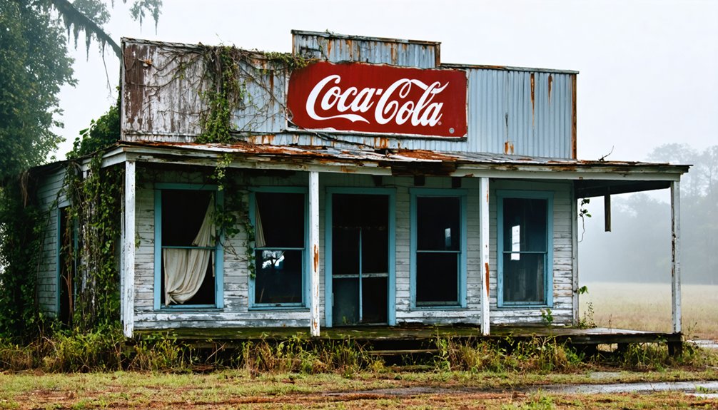
The harsh realities of delta living meant you’d face constant environmental threats, from hurricane strikes to erosion. While local folklore tells of a bustling port town, Burrwood’s infrastructure remained minimal – mostly temporary structures and industrial facilities that served the essential shipping channels. The Department of Defense maintained strategic oversight of the waterway operations due to their critical importance to national security.
You’d find your social life intertwined with work, as the community focused on surviving and thriving in this isolated outpost.
Environmental Forces and Natural Challenges
You’ll find Burrwood’s story is largely defined by the relentless forces of coastal erosion, which steadily consumed the town’s footprint along the Mississippi Delta.
Like many lost Louisiana towns, Burrwood’s decline reflects the shifting geographic and economic landscape of the region.
The marshland’s rapid deterioration accelerated as natural subsidence combined with storm impacts, creating a compounding pattern of land loss that made the area increasingly unstable. Hurricane Betsy devastated the region in 1965, marking one of the most destructive storms before Katrina.
The town’s position at the river’s mouth left it particularly vulnerable to these environmental pressures, where the continuous sinking of delta sediments worked in tandem with erosive forces to ultimately submerge most of the settlement.
Coastal Erosion Impact Analysis
As the Louisiana coastline faces relentless environmental forces, Burrwood’s disappearance exemplifies the devastating impact of coastal erosion in the Mississippi River Delta region.
You’ll find that environmental forces have accelerated land loss at an alarming rate – about a football field of wetlands vanishes every hour, with some areas near Burrwood completely stripped of their marshlands.
Despite coastal restoration efforts, persistent southerly winds, saltwater intrusion, and altered hydrology continue to reshape the landscape. The construction of oil and gas canals has significantly contributed to the degradation of freshwater marshlands in the region. Louisiana’s wetlands, once spanning 7.3 million acres, have diminished dramatically due to human activities disrupting natural processes.
The challenges of subsidence mitigation are compounded by barrier island erosion, which can reach up to 100 feet per year.
Without these natural buffers, interior wetlands lie exposed to the Gulf’s full force, leading to the permanent transformation of emergent wetlands into open water.
Delta Subsidence Acceleration Pattern
The delta’s subsidence patterns reveal a complex interplay of natural and human-induced forces that steadily reshape Louisiana’s coastal landscape. The region has experienced wetland loss equivalent to Delaware’s total area, highlighting the severe impact of subsidence on coastal territories.
You’ll find that subsidence factors vary considerably across the region, with rates reaching up to 25mm yearly in some areas. The Bird’s Foot Delta showcases the most dramatic changes, sinking at 16.8mm annually due to both natural processes and human activities.
- Picture vast stretches of wetlands slowly sinking beneath the waves, as shallow compaction squeezes ancient sediments like a compressed sponge.
- Watch as oil and gas extraction creates pockets of accelerated subsidence, causing the ground to sink faster than nature intended.
- Observe the flooding risks intensify where groundwater withdrawal and urban development amplify the natural subsidence, particularly around New Orleans.
The Slow Disappearance Beneath the Waters
While many Louisiana towns have faced environmental challenges, Burrwood’s descent beneath the waters of the Mississippi River delta stands as a stark example of nature’s relentless power.
You’ll find that this once-thriving delta community fell victim to a perfect storm of environmental forces. The town’s fragile foundation couldn’t withstand the combined assault of erosion, subsidence, and devastating hurricanes, particularly the brutal storms of 1917 and 1965.
The decline wasn’t just about nature’s fury – human activities played their part too. The destruction of protective wetlands and the weight of military infrastructure during WWII accelerated the town’s sinking.
Today, you’ll see little evidence of Burrwood’s existence except for a lonely pilots station, while rising seas and intensifying storms continue to reshape the delta ecology.
You’ll find Burrwood’s rich maritime heritage deeply woven into the Southwest Pass’s evolution as a critical Mississippi River port, where dredging operations and channel improvements transformed a shallow-draft waterway into a major shipping route.
During World War II, the port’s strategic location made it an essential U.S. Navy Section Base, hosting everything from PT boats to destroyers while protecting against German U-boat threats.
Ship pilots and crews navigated the challenging delta waters through an intricate network of passes and channels, relying on Burrwood’s facilities to support both commercial and military vessel operations.
Strategic Mississippi River Port
Located at a significant juncture of the Mississippi River’s Southwest Pass, Burrwood served as an indispensable maritime gateway controlling vessel traffic between the Gulf of Mexico and New Orleans.
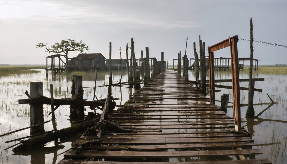
You’ll find this strategic port was pivotal for river commerce, equipped with heavy-duty docks that supported vessels ranging from pilot boats to destroyers. The port infrastructure included extensive facilities for the Army Corps of Engineers’ dredging operations, which maintained essential navigation channels for commercial and military ships.
- Massive docking facilities stretched along the riverbank, accommodating tugs, dredges, and naval vessels simultaneously
- Pilot stations dotted the waterfront, where officials inspected ships’ documentation and regulated river traffic
- Complex network of outer jetties and boarding stations controlled the flow of maritime commerce through the delta
During World War II, Burrwood transformed into an essential Naval Section Base that anchored Allied maritime operations across the Mississippi Delta region.
You’d find the USS Governor conducting crucial minesweeping operations from late 1942 through August 1945, protecting Allied shipping lanes from enemy threats. The base’s naval logistics capabilities supported roughly thirty vessels monthly with repairs, fuel, provisions, and medical services.
Beyond its maintenance role, Burrwood served as a critical communications and training hub.
You could spot officers managing inshore patrol vessels while communications teams handled encrypted messages for ships in the Gulf. The base’s integration with Army Artillery Districts strengthened coastal defenses through coordinated gun coverage, searchlights, and patrol zones – creating a formidable defense network that helped secure America’s southern maritime frontier.
Piloting Through Delta Waters
As an essential pilots station at the mouth of Southwest Pass, Burrwood played an irreplaceable role in managing maritime traffic entering the Mississippi River.
You’d find pilots steering vessels through treacherous delta waters, facing environmental challenges that required expert knowledge of the ever-changing channels. The station’s heavy-duty docks supported a range of vessels, from commercial ships to military craft, while ensuring proper documentation and compliance for safe passage upriver.
- Pilot boats cutting through the misty morning waters, ready to guide incoming vessels
- Seasoned navigators studying detailed charts of the shifting delta passages
- Dredges maintaining the critical channel depths against nature’s persistent silting
Burrwood’s maritime heritage lives on through its enduring pilots station, a reflection of the important role it played in delta navigation despite the harsh coastal environment that eventually claimed the town.
Lessons From a Lost Louisiana Community
The story of Burrwood offers sobering lessons about the vulnerability of coastal communities along Louisiana’s ever-changing shoreline.
You’ll find that this once-thriving naval base and port town, home to 1,000 residents, teaches hard truths about community resilience and urban planning in challenging environments.
Despite its strategic military importance during WWII and crucial economic role in maintaining Mississippi River navigation, Burrwood couldn’t overcome nature’s relentless assault.
The combination of coastal erosion, repeated hurricane strikes, and subsidence ultimately sealed its fate.
You can trace its decline through devastating events like the 1917 hurricane and Hurricane Betsy in 1965, which accelerated the town’s abandonment.
Today, Burrwood’s ghost town status serves as a stark reminder that even well-established coastal communities can vanish beneath Louisiana’s waters.
What Remains Today: A Solitary Pilot Station
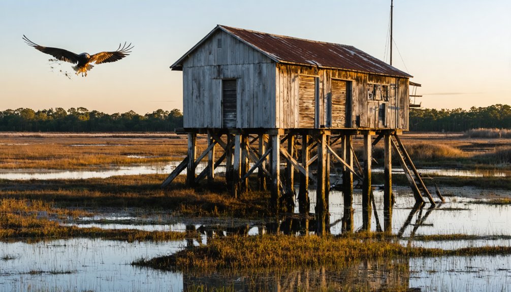
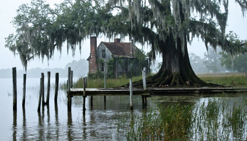
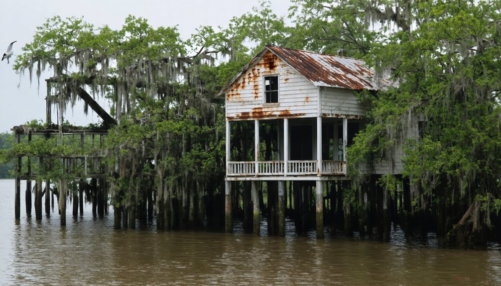
Rising solitary from Louisiana’s marshland, a lone pilots station marks the final remnant of what was once Burrwood.
You’ll find no roads leading here – only water and air access reach this isolated outpost, where temporary pilot quarters and weather monitoring equipment still stand just feet above the river’s surface.
While pilot operations have since moved upriver to Venice, this station’s presence recalls Burrwood’s crucial role in Mississippi River navigation history.
- Concrete walkways, raised above flood level, connect sparse buildings where pilots once guided ships through treacherous delta waters
- Satellite dishes and utility poles pierce the sky, ghosts of when modern amenities briefly served this remote station
- Weather-beaten structures rise from endless marsh, marking where WWII vessels once docked to guard against German U-boats
Frequently Asked Questions
What Was the Average Salary of Workers in Burrwood During Its Peak?
You’d find average wages ranged from $0.25 to $1.00 per hour during Burrwood’s peak in the 1940s, reflecting the historical economy of similar Gulf Coast naval and port communities.
Were There Any Schools or Churches Established in Burrwood?
Despite housing around 1,000 residents at its peak, you won’t find records of formal schools or churches in Burrwood. The town’s transient workforce and harsh environmental conditions prevented permanent educational or religious establishments.
How Did Residents Get Their Food and Supplies?
You’d get your supplies mainly from boats traveling river supply routes, while supplementing your pantry through local fishing techniques and shrimping in the rich Mississippi delta waters.
What Types of Recreational Activities Did Burrwood Residents Enjoy?
You’d spend your days enjoying fishing trips on the Mississippi Delta, joining military social events, participating in church activities, and attending community gatherings at the naval base and docks.
Did Any Famous Historical Figures Ever Visit Burrwood?
You won’t find records of famous figures visiting – there’s no historical significance tied to celebrity appearances. While the town holds ghostly sightings and memories, notable personalities didn’t venture to this remote outpost.
References
- https://www.eenews.net/articles/5-climate-ghost-towns/
- https://etsn.fm/ixp/33/p/7-louisiana-ghost-towns/
- https://en.wikipedia.org/wiki/List_of_ghost_towns_in_Louisiana
- http://wikimapia.org/6131917/Burrwood-Louisiana
- https://en.wikipedia.org/wiki/Burrwood
- https://coludrovich.tripod.com/parish_history.html
- https://apps.dtic.mil/sti/tr/pdf/ADA324386.pdf
- https://www.houmatoday.com/story/news/2002/09/29/war-in-the-gulf-much-history-can-be-found-from-the-naval-brigade-in-burwood/26803022007/
- https://lib.lsu.edu/sites/default/files/sc/findaid/5068.pdf
- https://www.crt.state.la.us/Assets/OCD/hp/nationalregister/historic_contexts/Transportation_in_Louisiana.pdf