You’ll find Caineville’s haunting remnants along Utah’s State Route 24, where this former pioneer settlement established in 1882 faced constant battles with the Fremont River’s unpredictable floods. Founded by Elijah Cutler Behunin, the town thrived briefly as a farming community until the devastating Great Flood of 1909 forced most residents to abandon their homes. Today, preserved structures like Behunin’s red sandstone cabin and the historic school-church building reveal compelling stories of frontier resilience and ultimate surrender to nature’s power.
Key Takeaways
- Caineville was established in 1882 by pioneer Elijah Cutler Behunin and became a farming community along the Fremont River in Utah.
- The devastating Great Flood of 1909 destroyed farmland and homes, triggering mass exodus and the town’s eventual decline.
- Historic structures include Behunin’s red sandstone cabin and a school-church building, preserved as symbols of pioneer settlement.
- Located 250 miles southeast of Salt Lake City, Caineville now attracts tourists interested in ghost town exploration and desert adventures.
- The town offers modern accommodations including motels and rental teepees while maintaining strict preservation of historical artifacts.
The Pioneer Legacy of Elijah Cutler Behunin
When Elijah Cutler Behunin arrived in Utah as a three-year-old child in 1850, he couldn’t have known he’d become a significant figure in Capitol Reef‘s pioneer history.
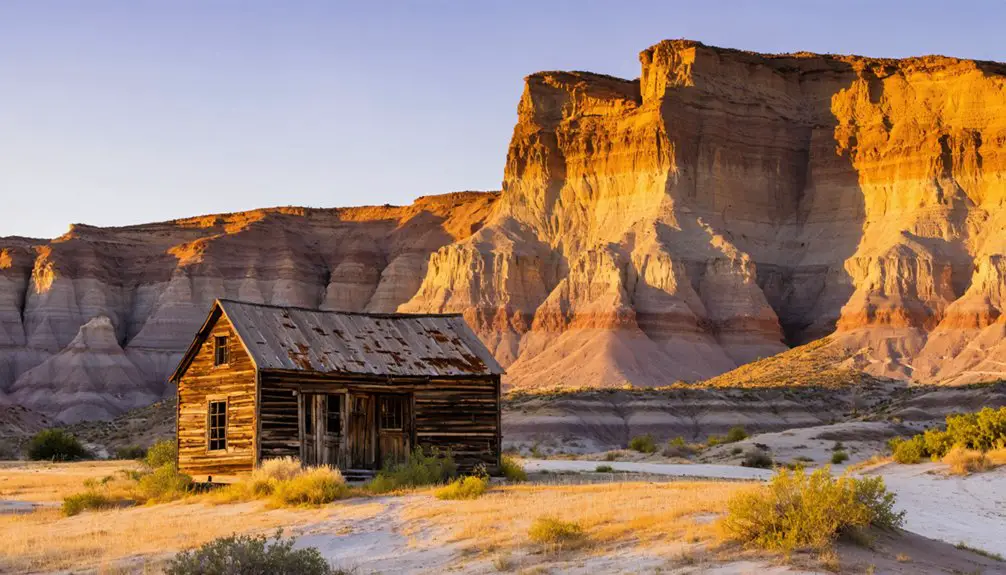
On November 18, 1882, he established a log cabin in Caineville where he would help build a thriving community.
His pioneer resilience shone through as he built the now-historic Behunin Cabin near the Fremont River and maintained essential wagon roads through Capitol Gorge to Fruita, despite relentless environmental challenges. Modern researchers can explore his family connections through historical records on genealogy websites.
Defying harsh desert conditions, Behunin carved out both shelter and passage through Capitol Reef’s unforgiving landscape.
You’ll find his historical significance deeply woven into the region’s fabric. Working alongside his sons, he kept crucial transportation routes open through flash floods and winter snows.
Though his family’s stay at the cabin lasted only a year before moving eastward to Notom, Behunin’s impact endures. The National Park Service preserves his cabin today, a symbol of the determined spirit of Utah’s frontier settlers and their adaptability in the untamed American West.
Life Along the Fremont River Banks
You’ll find that early Caineville settlers strategically positioned their homes and fields along the Fremont River banks, maximizing access to irrigation while building on slightly elevated ground to protect against seasonal flooding.
The pioneers engineered simple but effective irrigation systems using hand-dug ditches and wooden gates to direct water to their crops, though they’d frequently need repairs after flash floods damaged the infrastructure. The alluvial fan surfaces provided ideal locations for their agricultural development. This reliable water source enabled year-round irrigation for their farmlands in the valley.
Living conditions remained basic but sustainable, with families constructing adobe homes near their agricultural plots and developing communal systems to share water resources during drought periods.
Early Agricultural Settlement Methods
Along the banks of the Fremont River, early agricultural settlements flourished through a sophisticated blend of farming techniques and environmental adaptation.
You’ll find evidence of how these settlers strategically positioned their communities near well-watered areas, building sturdy pithouses of stone and mud alongside essential granaries for food storage.
The Fremont agriculture system mastered the cultivation of corn, beans, and squash – the “Three Sisters” – while maintaining connections to wild food gathering. These resourceful communities displayed distinct cultural practices that set them apart from their Ancestral Puebloan neighbors.
Archaeological evidence shows these settlements thrived during the Medieval Climatic Anomaly, providing ideal conditions for their farming practices.
You can trace their innovative irrigation techniques through ancient canals that later Mormon pioneers would mirror in their own farming efforts.
Their settlements ranged from small farmsteads to villages of several dozen homes, always prioritizing fertile valley floors and safe distances from flood-prone areas, showcasing their deep understanding of the land’s potential and limitations.
Water Management and Flooding
Living near the Fremont River brought both sustenance and danger to local communities, as flooding shaped the rhythm of daily life.
You’d face the river’s unpredictable nature, with peak flows reaching 21,400 cubic feet per second during 100-year flood events. While flood management efforts focused on protecting agricultural lands, the challenges extended beyond mere water control. A meander bend stretching 1.2 kilometers long was cut off due to road development, forever altering the river’s natural flow patterns.
You’d witness how road construction altered the river’s natural course, creating erosion hotspots and changing flood patterns. The September 2021 floods brought severe damage to ten local homes and disrupted business operations throughout the area.
Water quality became a pressing concern when floods overwhelmed local infrastructure, forcing sewage into the river and spreading E. coli contamination downstream.
If you lived in Hanksville, you’d particularly feel the impact, as parts of the town lay within Bull Creek’s flood plain, making both flooding and contamination serious threats to daily life.
Pioneer Family Living Conditions
Three distinct aspects defined pioneer life along the Fremont River banks: resourcefulness, community bonds, and environmental adaptation.
You’ll find pioneer resilience displayed in how families built homes from local materials while utilizing natural rock shelters and creating communal living spaces with ramadas for shade and social activities.
- Housing evolved from simple cabins to multi-room structures, clustering into small settlements for protection and cooperation.
- Families shared labor for farming, irrigation, and infrastructure development.
- Self-sufficiency thrived through diverse food sources – cultivating orchards, hunting game, and gathering wild plants.
Life demanded constant work, from maintaining irrigation systems to clearing land for crops. Like the Fremont People before them, settlers centered their communities near streams for fertile farming soil. Similar to ancient inhabitants who gradually transitioned from hunting to farming, these pioneers practiced part-time farming while still relying on wild resources.
Yet pioneers adapted skillfully, creating settlements that balanced isolation with strong community ties, all while maximizing the river valley’s natural resources for survival.
A Community Built on Faith and Agriculture
When Mormon Church missionary Elijah Cutler Behunin founded Caineville in 1882, he established more than just a settlement – he created a faith-centered agricultural community on the fertile banks of the Fremont River.
You’ll find that community resilience emerged through the blend of religious devotion and agricultural innovation. The settlement’s faith-driven agriculture focused on crops suited to the semi-arid climate, with settlers using river irrigation to grow corn, vegetables, and alfalfa.
The Mormon Church actively directed development while the school-church building served as both an educational and religious hub.
Despite challenges like the 1892-1893 diphtheria epidemic and devastating floods, shared religious faith motivated settlers to persevere.
Behunin’s red sandstone cabin became a symbol of their determination, representing both spiritual commitment and practical adaptation to the harsh environment.
Natural Forces Shape a Town’s Destiny
While faith and agriculture laid Caineville’s foundation, the raw power of nature ultimately shaped its destiny.
Despite human aspirations of taming the wilderness, nature’s relentless force remained the true architect of Caineville’s story.
You’ll find a cultural heritage deeply intertwined with environmental challenges, as the Fremont River’s frequent flooding repeatedly devastated the community’s infrastructure and agricultural efforts. The town’s struggle against nature reached its breaking point in 1909 when a catastrophic flood triggered mass abandonment.
- The rugged Capitol Reef gorge made travel treacherous, with pioneers like Walter Hanks traversing difficult terrain to establish settlement.
- Seasonal storms created hundreds of waterfalls cascading over Wingate cliffs, intensifying flood risks.
- Natural disasters, including the severe 1892-93 diphtheria outbreak and the devastating 1983 Utah flood, repeatedly tested the community’s resilience.
Today, you’re witnessing a landscape that proved too formidable for permanent settlement, where nature’s force prevailed over human determination.
The Great Exodus of 1909
In 1909, you’d have witnessed Caineville’s devastating transformation as floodwaters ravaged farmland, destroyed homes, and damaged essential irrigation systems along the Fremont River.
The catastrophic flood marked the breaking point for many families who’d already endured years of previous flooding and diminished agricultural productivity.
You’ll find that this event triggered a mass exodus of farmers and ranchers from the area, drastically reducing Caineville’s population and forever altering its status from a thriving county seat to a sparsely populated ranching community.
Devastating Floodwaters Strike Community
During the fateful summer of 1909, a devastating flood struck Caineville, Utah, fundamentally altering the community’s future. The roaring floodwaters destroyed years of pioneer labor, overwhelming farmlands and washing away critical irrigation infrastructure.
The flood’s impact extended beyond Caineville to neighboring settlements like Notom, Aldridge, and Blue Valley, marking a turning point in the region’s history.
The destruction was amplified by several key factors:
- Extensive grazing had reduced vegetation on hillsides, increasing runoff severity
- The area’s natural susceptibility to cloudburst floods made it particularly vulnerable
- The agricultural community’s dependence on irrigation systems left them economically exposed
You’ll find that community resilience was tested as many families chose to abandon their holdings rather than rebuild, leading to a dramatic population decline that transformed Caineville from a growing agricultural hub into a sparsely populated settlement.
Residents Abandon Their Homes
Following the catastrophic flood of 1909, Caineville’s once-vibrant population rapidly declined as farmers and ranchers abandoned their homesteads en masse.
Despite the community’s resilience through previous hardships, the flood’s destruction of fertile Fremont River farmland left families with no viable means to sustain themselves. You’ll find that the economic challenges proved insurmountable – costly infrastructure repairs, destroyed crops, and lost ranch assets forced settlers to seek opportunities elsewhere.
The exodus shattered the close-knit Mormon community structure, as schools, churches, and social institutions couldn’t survive with dwindling numbers.
Young residents left first, eliminating hopes of population recovery. What was once a thriving agricultural center transformed into open range land, with only a few hardy souls remaining to tell the tale of Caineville’s dramatic decline.
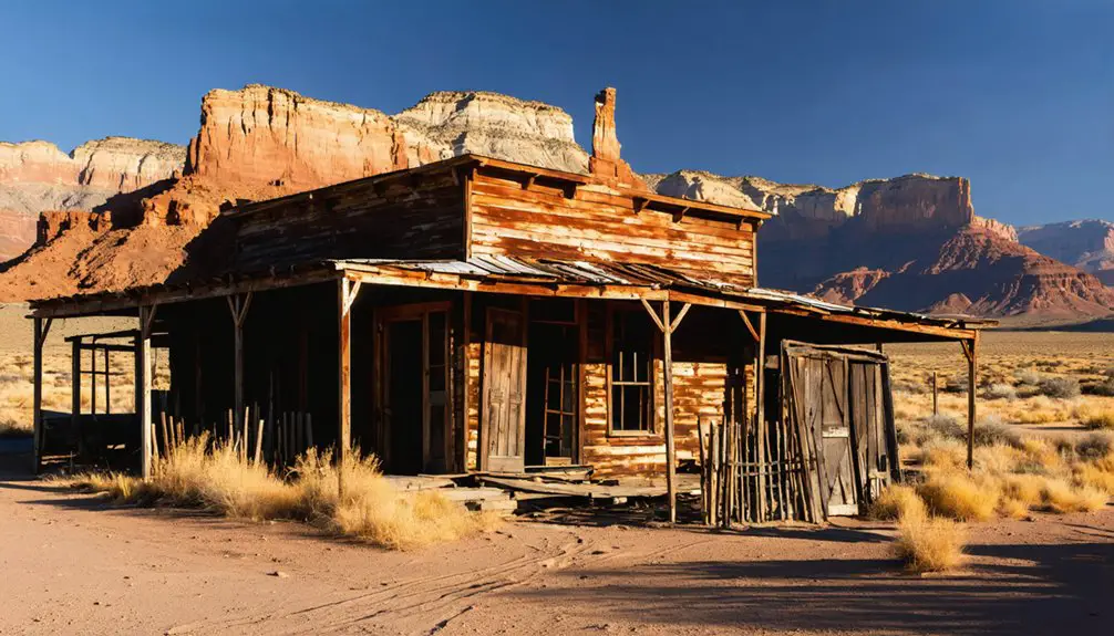
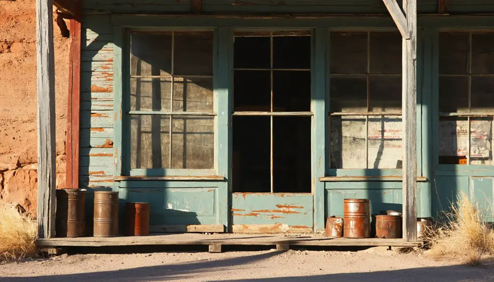
Surviving Structures and Historical Landmarks

The surviving structures of Caineville stand as silent witnesses to the town’s pioneering past, with several key buildings still visible along Highway 24.
You’ll find Behunin’s red sandstone cabin, masterfully crafted to blend with Capitol Reef’s natural landscape, alongside the historic school-church building that served as the community’s cultural center.
The cemetery’s weathered markers tell stories of pioneer resilience, particularly during the devastating diphtheria outbreak of 1892-93.
- The architectural resilience of these structures has withstood harsh desert conditions and flooding
- Local materials, including native red sandstone, showcase pioneer ingenuity in construction
- Despite abandonment, these landmarks continue serving as crucial historical markers for modern visitors
Today, these enduring structures provide a tangible connection to Caineville’s frontier heritage through heritage tourism and educational opportunities.
From Thriving Settlement to Desert Solitude
You’ll find that Caineville’s promising agricultural settlement met its downfall through devastating floods, particularly the catastrophic 1909 flood that forced many farmers to abandon their lands permanently.
The once-thriving riverbank farms gradually surrendered to erosion and desert reclamation, while surviving pioneer structures stand as evidence to early settlers’ determination.
Though most residents left, some ranching activity continues today near the ghost town, where improved irrigation methods have enabled limited cultivation amid the harsh desert landscape.
Floodwaters Shape Town’s Fate
While Caineville’s initial settlement in 1882 promised agricultural prosperity along the Fremont River’s fertile banks, devastating floods would ultimately seal the town’s fate.
The flood impacts reached their peak in 1909, when a catastrophic event forced many farmers and ranchers to abandon their dreams of agricultural success.
You’ll find these dramatic changes shaped Caineville’s destiny:
- Severe cloudbursts and snowmelt regularly transformed the landscape, depositing mud and debris across once-fertile farmlands.
- Agricultural decline accelerated as flooding reshaped river courses and damaged critical infrastructure.
- Repeated flood events deterred new settlers, pushing the town toward its eventual ghost town status.
Today, you can witness the lasting effects of these natural forces, as Caineville stands as a monument to nature’s power over human settlement in Utah’s challenging terrain.
Hope Amidst Desert Ruins
Despite the harsh realities of desert life and devastating floods that drove many residents away, Caineville’s story doesn’t end with abandonment.
You’ll find evidence of community resilience in the remaining structures, like Behunin’s red sandstone cabin and the school-church building, which stand as proof of the settlers’ determination.
Modern desert adaptations have breathed new life into this historic area. You can now explore the ghost town while staying at nearby motels and RV parks, or venture into the backcountry on guided tours.
Improved irrigation techniques have allowed some farming to return to lands once lost to erosion. While Caineville may never regain its former glory, its proximity to Capitol Reef National Park guarantees that visitors continue to discover its rich history among the desert ruins.
Modern Tourism and Desert Adventures
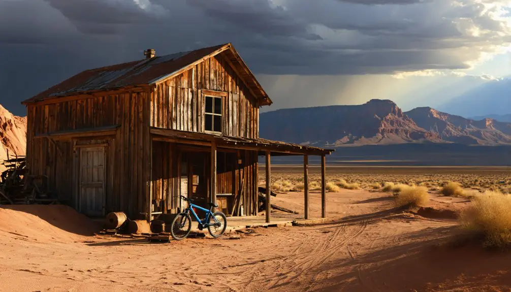
Although Caineville retains its ghost town status, the area has evolved into a compelling destination for desert adventurers and history enthusiasts.
You’ll find modern accommodations ranging from motel rooms to rental teepees, alongside opportunities for desert exploration through guided backcountry tours. At 4,600 feet elevation, the moderate climate supports year-round outdoor activities near Capitol Reef National Park.
- Trek through rugged canyons and desert terrain by foot or horseback
- Explore preserved historical sites, including Behunin’s sandstone cabin and the original school-church
- Fish along the Fremont River or camp under starlit desert skies
The town’s sparse population maintains its authentic ghost town atmosphere while supporting a tourism economy that blends wilderness experiences with heritage preservation, just 250 miles southeast of Salt Lake City.
The Battle Against Nature’s Elements
The harsh realities of Utah’s desert environment have shaped Caineville’s history far beyond its tourist appeal. You’ll find that natural disasters and environmental challenges have consistently tested the resilience of this settlement, much like other Utah ghost towns that faced similar battles against nature’s elements.
When you explore Caineville, you’re witnessing the aftermath of persistent flooding that plagued Utah’s settlements at the turn of the 20th century. The combination of unstable soil conditions, silt accumulation, and severe drought cycles made sustainable farming nearly impossible.
You’ll need to watch for desert wildlife, particularly rattlesnakes, during warmer months. The region’s extreme weather patterns, from flash floods to intense heat, continue to shape the landscape, while erosion steadily impacts the remaining structures, telling a story of humanity’s struggle against unforgiving natural forces.
Preserving Memories of a Lost Settlement
While many ghost towns fade into obscurity, Caineville’s rich history lives on through carefully preserved structures and documented memories.
You’ll find tangible evidence of community resilience in the original 1882 Behunin cabin, the school-church building, and cemetery that stand as proof of the settlers’ determination.
The historical significance of this settlement remains protected through:
Preserving Caineville’s pioneering legacy through strict protection measures ensures its historical treasures remain intact for generations to come.
- Strict preservation regulations preventing artifact removal and vandalism
- Conservation efforts focused on stabilizing historic structures against weathering
- Detailed documentation of pioneer stories, from the 1892 diphtheria outbreak to the devastating 1909 flood
You can experience this heritage through guided tours, interpretive trails, and authentic historical displays, ensuring these pioneer stories continue inspiring future generations while respecting the site’s cultural importance.
Frequently Asked Questions
What Was the Average Temperature and Rainfall in Caineville During Its Peak?
You’ll find Caineville climate records show summer highs around 90°F (32°C) and winter lows near 22°F (-6°C), with sparse rainfall averaging 0.21-0.26 inches during wet days throughout the year.
Were There Any Notable Conflicts Between Settlers and Native Americans?
Ever wonder about Utah’s bloodiest conflicts? You’ll find settler conflicts near Caineville mirrored the broader Black Hawk War (1865-1872), where native relations deteriorated into violent raids, cattle theft, and retaliatory killings by both sides.
How Much Did Land Cost When Caineville Was First Established?
You won’t find exact historical pricing records for Caineville’s initial land value. Mormon settlement practices emphasized community development over sales, though nearby federal homesteads typically cost $1.25 per acre.
What Industries Besides Agriculture Existed in Early Caineville?
While 85% of settlers relied on farming, you’d find thriving industries in construction, lumber production, livestock ranching, and brick-making. Mining opportunities were limited, but transportation routes supported these secondary economic activities.
Did Any Famous Outlaws or Gunfighters Ever Pass Through Caineville?
You’ll find that Butch Cassidy and his Wild Bunch gang frequently passed through, using nearby Robbers Roost as their hideout. Outlaw legends and gunfighter tales remain deeply woven into the area’s history.
References
- https://www.onlineutah.com/cainevillehistory.shtml
- https://capitolreefcountry.com/caineville/
- https://travelwitht.wordpress.com/2009/06/16/a-ghost-town/
- https://capitolreefcountry.com/ghost-towns/
- https://kids.kiddle.co/Caineville
- https://www.nps.gov/places/behunin-cabin.htm
- https://www.findagrave.com/memorial/12244921/elijah_cutler-behunin
- https://ancestors.familysearch.org/en/KWCB-PP2/elijah-cutler-behunin-1847-1933
- https://history.churchofjesuschrist.org/chd/individual/elijah-cutler-behunin-1847?lang=en
- https://www.nps.gov/care/learn/historyculture/pioneer-settlers.htm


