Garlock was a pivotal gold mining settlement in California’s Mojave Desert that flourished between 1896-1904. Originally called Cow Wells, the town gained prominence when Eugene Garlock established an eight-stamp mill processing up to 20 tons of ore daily from the nearby Randsburg district. The 1898 Kramer-Randsburg Railroad ultimately bypassed Garlock, leading to its abandonment. Now designated as California Historical Landmark #671, its weathered adobe ruins testify to the boom-and-bust cycle of frontier mining communities.
Key Takeaways
- Garlock originated in the 1880s as a water stop before transforming into a gold mining hub following nearby discoveries in 1893.
- Eugene Garlock’s eight-stamp mill became the town’s economic center, processing up to 20 tons of ore daily at its peak.
- The town declined after the 1898 Kramer-Randsburg Railroad bypassed it, with the post office closing by 1904.
- Designated California Historical Landmark #671 in 1958, the site preserves mining-era structures and equipment.
- Located in the Mojave Desert at 2,169 feet elevation, visitors can access the ghost town via Garlock Road off Highway 395.
The Origins of Garlock: From Cow Wells to Mining Hub
Before it became known as a mining hub, Garlock began as a modest water stop called Cow Wells or El Paso City during the 1880s and early 1890s.
Located in Kern County’s Mojave Desert near the Rand Mountains, this essential water source served cattlemen and freighters traveling the Searles Brothers stage road established in 1873.
The area’s transformation began when prospectors discovered a $1,900 gold nugget near Randsburg in 1893, triggering a regional gold rush. The town primarily served to supply water to nearby mines and the growing settlement of Ransburg.
Eugene Garlock’s establishment of an eight-stamp mill in 1896 revolutionized local mining techniques, processing ore from the Yellow Aster Mine and other operations.
This mill became the settlement’s heart, with the community adopting Garlock’s name as miners, businesses, and approximately 100 residents gathered around this crucial processing center. The town’s importance eventually diminished with the completion of railroad that provided more efficient transportation for mining materials around 1898.
Eugene Garlock and the Mill That Built a Town
Though numerous individuals shaped Garlock’s development, Eugene Garlock’s pivotal contribution materialized in the fall of 1895 when he hauled an eight-stamp mill from Tehachapi to the Cow Wells site.
His vision transformed the area into a processing hub for gold ore from the El Paso and Rand Mountains. The mill’s strategic location near reliable water sources proved ideal for processing ore from the Yellow Aster Mine and surrounding claims.
You’ll find that Garlock’s enterprise quickly became the town’s economic engine, attracting miners, merchants, and families who established businesses to support mill operations. At its height, the mill processed up to 20 tons daily of valuable ore from nearby mines.
The economic prosperity of Garlock was at its peak when the town employed 65 men at the Yellow Aster mine operation by late 1897.
The mill’s economic impact was profound but short-lived. When the Kramer-Randsburg Railroad arrived in 1898, ore shipments bypassed Garlock, leading to the mill’s closure.
Today, the site stands as California Historical Landmark #671.
Boom Years: Life in a Desert Mining Community
Following Garlock’s establishment of the mill, a vibrant if challenging community blossomed in this harsh desert landscape between 1896 and 1904. You’d have found 15-20 miners working in primitive conditions, living in a makeshift settlement of tents and simple wooden structures.
The mining culture revolved around the mill, where ore from Randsburg and El Paso Mountains underwent processing that required significant water—delivered via a 12-mile pipeline supplying 250,000 gallons. The stamp mill, built by Eugene Garlock in 1894, became the economic heart of the growing settlement.
Desert survival meant confronting extreme temperatures, resource scarcity, and isolation. The post office provided a crucial administrative link, while Garlock Road connected this outpost to civilization.
Social tensions manifested in claim disputes and claim-jumping incidents. When the railroad arrived in the 1920s, it briefly revitalized the community before mining activity shifted elsewhere.
Water, Gold, and Commerce in the Mojave
The lifeline of Garlock’s existence in the harsh Mojave Desert centered around three essential elements: water, gold, and commerce.
Water, gold, and commerce – the desert trinity that breathed life into Garlock amid the unforgiving Mojave.
Originally known as Cow Wells, this settlement became important for providing water to nearby mining towns, particularly Randsburg, through constructed pipelines. Over 1,000 miners sought their fortune in the El Paso mountains surrounding the area between 1893 and 1896. Eugene Garlock’s eight-stamp mill, established in 1896, temporarily elevated the town’s significance in processing ore from the Yellow Aster Mine.
You would have witnessed Garlock’s strategic position as a key supply hub for miners, cattlemen, and freight haulers traversing the dangerous desert terrain. The town sits along the Garlock Fault, a major geological feature that runs along the northern edge of the Mojave Desert.
However, when larger mills with independent water sources were built in Barstow and at the Yellow Aster Mine, water scarcity became inevitable. This infrastructure shift, coupled with mining decline when operations moved elsewhere, ultimately transformed this once-bustling commercial center into the ghost town that remains today.
The Railroad Bypass That Sealed Garlock’s Fate
While Garlock’s strategic position initially established its importance in the Mojave Desert landscape, the 1898 completion of the Kramer-Randsburg Railroad by Atchison, Topeka & Santa Fe Railway delivered a fatal blow to the settlement’s prospects.
This critical railroad logistics decision bypassed Garlock entirely, directing rail traffic straight to Randsburg where mining activities were intensifying.
You can trace Garlock’s economic decline directly to this pivotal moment. The railroad’s routing coincided with water being piped from Garlock to Randsburg and larger mills being constructed in Barstow.
The former hub quickly lost its competitive advantage in ore processing and transportation. By 1904, the post office closed—a clear indicator of Garlock’s diminishing relevance.
Without rail access, the town couldn’t compete with settlements directly connected to this crucial lifeline.
Ghost Town Geography: Location and Landscape
Today’s remnants of Garlock occupy a uniquely positioned segment of California’s Mojave Desert landscape, where geography played a defining role in both its rise and demise.
Nestled in Fremont Valley at 2,169 feet elevation, you’ll find this ghost town amid the arid Mojave Desert ecology, 7.4 miles west of Highway 395. The surrounding Rand and El Paso Mountains influenced the mining geology that birthed Garlock as a critical water source and ore-processing center. The area grew rapidly following gold and silver discovery in 1896. Originally known as Cow Wells, this settlement was renamed after Eugene Garlock, who established the stamp mill in 1896.
Four essential geographic features shaped Garlock:
- Strategic valley corridor positioning that created natural transportation routes
- Proximity to Yellow Aster Mine’s rich deposits requiring processing facilities
- Rare desert water access that supported both town life and neighboring communities
- Remote terrain between mountains that ultimately couldn’t compete when railroads bypassed it
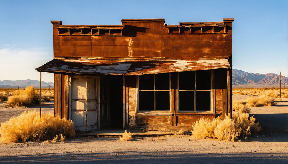
Preserved Remnants: What Survives Today

Silent sentinels of a once-thriving mining community, Garlock’s preserved remnants offer visitors a tangible connection to California’s gold rush era despite decades of abandonment and desert weathering.
Weathered walls whisper stories of golden dreams amid the silent, sun-bleached ruins of California’s forgotten frontier.
As you travel along Garlock Road, you’ll encounter scattered ruins of homes, businesses, and administrative structures, including a former post office and operations center. The desert climate has contributed to the preservation of some structures compared to what would occur in tropical regions with higher rainfall.
The abandoned architecture consists mainly of partial walls, doorways, and foundations, with environmental impacts evident in the desert’s reclamation of the site.
California Historical Landmark #671 stands nearby, documenting Eugene Garlock’s contributions and the town’s mining significance.
The old Southern Pacific Railroad line still runs adjacent to the site, a symbol of the transportation infrastructure that once fueled Garlock’s economy before its eventual decline and abandonment.
Historical Significance and California Landmark Status
Garlock’s historical significance has been officially recognized through its designation as California Historical Landmark #671 on December 1, 1958, commemorating its pivotal role in the Randsburg mining district.
The landmark status preserves the memory of this short-lived but essential gold mining support community that served as both water supplier and ore processor during California’s later gold rush period.
You’ll find the official state historical marker 7.4 miles west of Highway 395 on Garlock Road, where it stands as a tribute to the town’s contribution to California’s mining heritage despite its brief existence spanning less than a decade.
Historical Landmark Designation
Despite its current ghost town status, the historic settlement of Garlock earned official recognition as California Historical Landmark No. 671 on December 1, 1958. This designation acknowledges Garlock’s significance in California’s mining heritage and guarantees historical preservation of this once-thriving community centered around Eugene Garlock’s 1896 stamp mill.
The landmark site is strategically located in Kern County’s Mojave Desert region:
- Situated in Fremont Valley near present-day Cantil
- Located 7.4 miles west of State Highway 395 on Garlock Road
- Positioned 13.4 miles northeast of the Cantil post office
- Connected via Garlock Road to Redrock-Randsburg Road and US Route 395
The official marker, placed around 1960, commemorates Garlock’s pivotal role in regional mining development before railroad expansion altered transportation patterns.
Mining Heritage Recognition
Although no longer bustling with mining activity, the ghost town of Garlock holds a distinguished place in California’s mining heritage recognition system. Designated as California Historical Landmark #671 on December 1, 1958, Garlock commemorates the site’s vital role in the Mojave Desert’s mining history.
You’ll find the landmark marker 7.4 miles west of Highway 395 on Garlock Road, acknowledging the town’s significant contribution to regional mining techniques. Established in 1896, Garlock’s stamp mill revolutionized ore processing from the Yellow Aster Mine, transforming small-scale prospecting into industrial operations.
The town became essential to the mining supply chain, demonstrating remarkable community resilience despite water scarcity challenges. After the 1893 gold discovery near Randsburg, Garlock emerged as a key hub for miners and freighters, supporting operations throughout the Rand Mountains.
Gold Rush Preservation
The preservation of Garlock as a gold rush site represents an ongoing commitment to California’s mining legacy.
When you visit this California Historical Landmark #671, designated in 1958, you’re witnessing the protection of authentic gold mining history.
Eugene Garlock’s stamp mill processed ore from Yellow Aster Mine, transforming Cow Wells into a thriving supply center during the late 19th-century Southern California gold rush.
Modern preservation techniques include:
- Installation of educational signage detailing mining operations
- Protection of remaining adobe and frame structures
- Maintenance of original mining equipment and contraptions
- Legal safeguards through official historical registration
The site’s minimal development preserves its ghost town atmosphere while ensuring this significant piece of California’s gold frontier remains accessible for educational exploration and historical tourism.
Visiting Garlock: Access and Important Information
Located in the heart of the Mojave Desert at an elevation of 2,169 feet, Garlock offers explorers a genuine ghost town experience that requires careful planning and preparation.
Venture into authentic desert history where preparation isn’t just recommended—it’s essential for survival.
You’ll find this historic mining settlement in Kern County, approximately 40 miles northeast of Mojave and just 7.5 miles west of Redrock.
Access is primarily via Garlock Road, connecting to Highway 395. For precise navigation, use GPS coordinates 35.4025°N, -117.794°W.
Desert travel tips include bringing a vehicle with good clearance, as unpaved roads can be challenging. Desert safety is paramount—carry ample water, emergency supplies, and layered clothing for temperature fluctuations.
Cell reception is unreliable, so plan accordingly. Remember to respect private property boundaries and follow Leave No Trace principles.
There are no facilities at this uninhabited site, so arrange accommodations in nearby towns.
Frequently Asked Questions
Are There Any Paranormal Reports or Ghost Stories About Garlock?
You’d expect ghost sightings in such a desolate place, yet documented paranormal reports about Garlock are remarkably absent. Despite its haunted locations aesthetic, historical records show no verified supernatural events beyond fictional portrayals like “The Garlock Incident.”
Who Owns the Remaining Buildings and Land in Garlock Today?
You won’t find clear public records on property ownership in Garlock. The remaining buildings likely fall under private custody or Bureau of Land Management jurisdiction, though specific land management details remain undocumented.
Was Any Gold Discovered Directly in Garlock Itself?
Fundamentally, facts show no gold was discovered directly in Garlock itself. You’ll find the town’s purpose was processing ore from elsewhere, despite local legends that might suggest otherwise. Gold mining occurred nearby instead.
Did Any Famous Historical Figures Ever Visit Garlock?
You won’t find famous visitors documented in Garlock’s history. Despite its regional historical significance as a mining support town, there’s no evidence that nationally recognized historical figures ever visited this remote settlement.
What Happened to Eugene Garlock’s Family After His Death?
Historical records don’t reveal what happened to Eugene Garlock’s family descendants. You’ll find his personal legacy overshadowed by the town’s history, with no documented continuation of his family line after 1907.
References
- https://www.youtube.com/watch?v=TtizydEZDkg
- http://www.gribblenation.org/2025/07/garlock-road-and-garlock-ghost-town.html
- https://en.wikipedia.org/wiki/Garlock
- https://www.youtube.com/watch?v=8uZNffkANkk
- https://scvhistory.com/scvhistory/lw2366c.htm
- https://digital-desert.com/garlock/
- https://www.ghosttowns.com/states/ca/garlock.html
- https://tisqui.github.io/2017/09/27/garlock.html
- https://ohp.parks.ca.gov/ListedResources/Detail/671
- https://scvhistory.com/scvhistory/lw2366b.htm


