
Roachville was a short-lived mining settlement established in 1861 in California’s desert region. You’ll find it located 12 miles southeast of Halivah, built around silver extraction on the White Mountains’ eastern slope at 5,800 feet elevation. The town flourished between 1861-1870 before declining due to depleted ore yields, with final abandonment by 1878. Today, its remote location requires high-clearance vehicles and careful preparation. The story of this forgotten outpost reveals much about California’s mining frontier.
Key Takeaways
- Roachville was a silver mining settlement established in 1861 in California’s desert region at an elevation of 5,800 feet.
- The town experienced its peak years between 1861-1870 before declining due to reduced silver yields and unprofitable mining operations.
- By 1878, Roachville was completely abandoned after its post office closed in 1875 and final businesses shuttered.
- Located 12 miles southeast of Halivah in Inyo County, Roachville was part of a network of mining communities.
- Visiting requires a high-clearance vehicle, with spring and fall offering the best conditions for exploring the remaining structures.
The Birth of a Mining Settlement (1861)
In 1861, the dusty stretches of California’s desert region welcomed a new settlement as Roachville emerged from the ambitious prospecting activities that had spread southward from the 1849 Gold Rush sites. Much like nearby Claraville, Roachville took shape about 12 miles southeast of what would later become Halivah.
You’ll find that prospecting techniques were relatively simple then—explorers established temporary camps while seeking silver veins rumored to extend from Mexican mines northward.
After discovering promising deposits, miners staked their claims by building rock monuments at four corners and posting location notices containing critical information. These mining claims, typically 1500 by 600 feet, required $100 of annual assessment work to maintain legal rights.
Financial backing from established businessmen like D.C. Kuffel helped transform individual claims into coordinated operations. The Bureau of Land Management has documented how these early mining settlements contributed to the 200-year history of mineral extraction in the California Desert Conservation Area.
Life Among the White Mountains
You’d have found daily life in Roachville and White Mountain City incredibly demanding, with miners facing harsh mountain conditions at 5,800 feet elevation while pursuing modest gold and silver deposits.
The transient population struggled through bitter winters, making most mining operations seasonal affairs concentrated during the milder summer months.
Your existence would’ve centered around basic amenities in these small supply centers, where social gatherings at local establishments provided rare respite from the isolation and physical challenges of mountain prospecting. These settlements were established after gold discoveries at Coso in 1861, drawing ambitious prospectors to this unforgiving landscape. The harsh conditions experienced by these settlers were similar to those later studied by researchers at WMRC facilities which began operating in the region in 1948.
Rugged Mountain Settlement
Nestled within the stark and unforgiving White Mountains of California, Roachville emerged in the early 1860s as a determined mining settlement that clung to the steep, rocky terrain.
Officially surveyed by 1864, the town formed alongside White Mountain City as part of the expanding Tarrytown mining district.
You’d have found a community shaped by its challenging environment, with Cottonwood Creek providing the precious water that made life possible amid the arid landscape.
Daily existence demanded community resilience, as residents battled extreme temperature shifts and isolation.
The rugged terrain dictated everything from housing construction to travel routes, with unpaved roads frequently rendered impassable by weather.
Despite these hardships, Roachville established a functional society with planned streets, mining claims, and businesses that served the determined souls who called this remote outpost home.
Roachville’s founding in 1861 specifically places it among numerous other frontier settlements established that same year across America during the mining boom era.
Miners’ Daily Struggles
While fortune seekers flocked to Roachville with dreams of striking it rich, the harsh reality of daily existence in the White Mountains quickly tempered their expectations.
You’d wake before dawn, descending into unstable tunnels where dust filled your lungs and danger lurked at every turn. Your body ached from hauling ore until dusk.
Daily hardships extended beyond the mines. Water and food shortages plagued the settlement, with primitive roads often cut off by weather.
Your cramped, poorly insulated shelter offered little comfort against extreme temperatures. Illness struck frequently, with medical help days away. This settlement shares only its name with other Roachville locations that appear in geographical disambiguation resources.
Despite these challenges, miners’ resilience shone through. You’d supplement meager or irregular wages by hunting and gathering. By 1864, the town had grown enough to establish surveyed town plats alongside White Mountain City.
Communal bonds formed through shared struggles, creating a rugged solidarity essential for survival in Roachville’s unforgiving environment.
White Mountain Survival
Living among the White Mountains demanded extraordinary adaptation skills from both human settlers and natural ecosystems.
You’ll witness ecological resilience in the bristlecone pines thriving at elevations between 9,200-11,500 feet, with some specimens surviving over 4,800 years through extreme climate variations.
The alpine adaptation of indigenous Paiute tribes established seasonal patterns that sustained generations, including:
- Summer hunting camps at elevations up to 13,100 feet
- Harvesting piñon pine nuts as winter staples
- Developing sustainable resource management practices
When European settlers arrived mid-19th century, they introduced livestock practices that dramatically altered the mountain ecosystem.
Their grazing cattle and disease-carrying sheep nearly decimated native Bighorn populations.
The range stretches approximately 60 miles in length with varying width, creating diverse habitats across its triangular fault-block formation.
One of the most famous residents of these mountains is Methuselah tree, a bristlecone pine whose exact location remains secret to protect it from potential damage by tourists.
Today, scientific research stations established since 1950 document the ongoing struggle and resilience of these remarkable mountain environments.
Mining Operations and Economic Impact
Although established as a humble settlement in 1861, Roachville quickly developed around the silver extraction operations on the east slope of the White Mountains.
The Roachville Mine became the community’s economic backbone, providing employment and attracting prospectors seeking fortune in California’s rugged terrain.
You’d find the town’s prosperity directly tied to silver prices and mining output. During boom periods, businesses flourished—supply stores, lodging, and services catered to miners and their families.
However, these economic fluctuations made life precarious. Similar to the operations at Copper World mine in the late 1890s, which ranked among the four largest copper mines in the U.S., the mine operated intermittently due to challenging terrain, limited water access, and the difficulties of transporting equipment to such a remote location. Miners endured harsh working conditions, often spending over 10 hours in dark, hot environments similar to those experienced in the Kennedy Mine.
Daily Life in Roachville’s Heyday
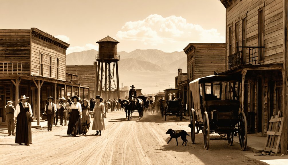
As the morning fog lifted over Roachville during its peak years between 1861 and 1870, you’d find a bustling community awakening to another day of harsh realities and simple pleasures.
A forgotten gold town emerges from the mist, where harsh toil met humble joy in America’s western frontier.
Daily routines revolved around dawn-to-dusk labor, with scarce leisure time spent in saloons playing cards or sharing stories. Your home would’ve been a simple wood structure with a wood-burning stove fighting against mountain winters.
Community bonds formed naturally through:
- Mutual aid networks during times of illness or hardship
- Social gatherings in multi-purpose spaces where religious services occasionally occurred
- Shared meals of preserved meats and beans, supplemented by hunting when possible
You’d communicate through infrequent mail runs, rely on wagon deliveries for supplies, and adapt to seasonal changes that shaped your self-reliant existence.
Decline and Abandonment
The slow death of Roachville began in the late 1860s when silver and lead ore yields diminished considerably throughout the region.
Economic decline quickly followed as mining operations became unprofitable and nearby competition outperformed the town’s exhausted veins. Without investment in new technologies, the mines couldn’t sustain operations.
You would have witnessed a rapid population migration after 1870, with residents seeking opportunity elsewhere in booming towns like Bodie and Aurora.
Services vanished in quick succession—the post office closed in 1875, the schoolhouse in 1876, and the last business shuttered by 1878.
Neighboring Ghost Towns of Inyo County
While exploring Roachville, you’ll discover it existed within a vast network of mining communities that dotted Inyo County during the late 19th century.
You can trace the historic exploration routes connecting Roachville to neighboring ghost towns like Cerro Gordo, Darwin, and Ballarat, each with their own unique stories of boom and bust.
These interconnected settlements formed a critical economic web across the harsh desert landscape, sharing resources, workers, and transportation infrastructure as they collectively shaped the mining heritage of Eastern California.
Mining Community Network
Mining communities across Inyo County formed an interconnected network that supported Roachville’s development and sustainability during the region’s mineral boom.
When exploring this area, you’ll discover how these settlements shared mining technology and created substantial economic impact, collectively producing over $150 million in precious metals.
The mining network functioned through:
- Strategic transportation systems including cable tramways that connected mountain mines to processing facilities
- Shared smelting operations in Keeler that processed high-grade ore from multiple mining districts
- Economic interdependence where towns like Darwin, Cerro Gordo, and the Reward Mine area specialized in different minerals yet relied on each other’s infrastructure
This regional cooperation allowed smaller operations like Roachville to thrive despite fluctuating mineral demands, creating a resilient mining economy throughout Inyo County.
Geographic Exploration Routes
Roachville’s mining story extends beyond its boundaries to a fascinating network of ghost towns scattered throughout Inyo County.
You’ll find Cerro Gordo 15 miles northeast of Keeler, accessible via a challenging 4WD road that navigates steep Inyo Mountain terrain. For more historical landmarks, head to Ballarat in the Panamint Valley, about 30 miles west of Death Valley Junction.
The terrain challenges increase when exploring Ashford Mill, 10 miles south of Ballarat, where mining remnants still dot the landscape.
Adventurous travelers can trek 20 miles north of Ballarat to reach Agueberry Camp via rugged Panamint Range trails offering spectacular views.
Don’t miss Armagosa Borax Works, 25 miles south of Death Valley Junction across the sparse Amargosa Desert, where interpretive signage reveals its industrial past.
What Remains Today: A Visual Tour
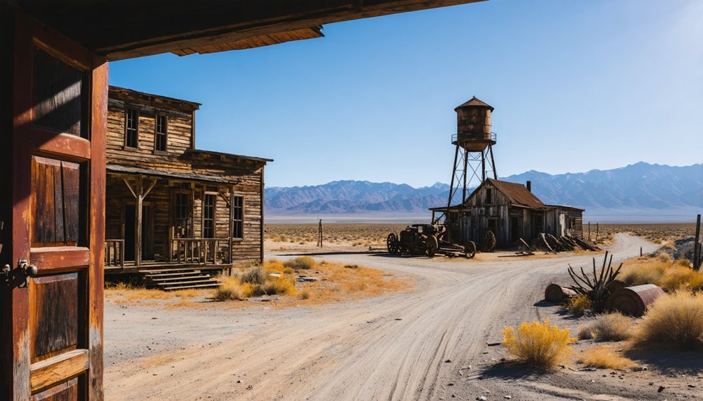
Visitors to Roachville today encounter a haunting tableau of weathered structures and scattered remnants from the town’s heyday.
The schoolhouse stands as the most intact structure, its weathered walls bearing witness to both history and modern graffiti. Surrounding hills reveal the scars of mining operations, while nature steadily reclaims the landscape through persistent sagebrush and juniper growth.
For ideal Artifacts Discovery during your exploration:
- Examine cabin foundations for household items and ceramic fragments
- Search near mining sites for rusted tools and equipment remnants
- Visit the creek bed where erosion often exposes previously buried items
Landscape Preservation efforts remain minimal, with only documentation by historical societies and occasional archaeological surveys protecting Roachville’s legacy from further deterioration and vandalism.
Visiting Roachville: Practical Information for Explorers
Planning a journey to Roachville requires thorough preparation due to the ghost town‘s remote location in California’s eastern Sierra Nevada region.
Exploring the history of Timbuctoo, California can offer a fascinating glimpse into the past, as this area once thrived during the gold rush. Visitors might stumble upon remnants of old structures, which echo stories of the settlers who sought fortune in this remote part of the Sierra Nevada. A trip to this ghost town not only uncovers its unique history but also provides stunning views of the surrounding landscape.
You’ll need a high-clearance vehicle to navigate the rugged terrain near the 37°27’19″N 117°59’17″W coordinates.
For visitor safety, bring at least 2-3 gallons of water per person and emergency communication devices, as cellular coverage is minimal.
The ghost town’s deteriorated structures present hazards, so explore with caution.
Environmental challenges include dramatic seasonal variations.
Spring and fall offer ideal visiting conditions, while summer brings intense desert heat and winter often renders roads impassable with snow.
The nearest resources are in Bishop and Lone Pine, 81 kilometers away, so arrive with a full fuel tank and ample supplies.
Frequently Asked Questions
Was Roachville Named After a Person or the Insect?
In the wildest historical mystery ever, you can’t confirm Roachville’s origins with certainty. Research shows no definitive evidence whether it was named after a person or if insect influence inspired its naming.
Were There Any Notable Crimes or Lawlessness in Roachville?
You’ll find no documented notable crimes in Roachville. Historical records show no significant criminal activity or lawlessness, and the town had minimal law enforcement presence typical of small mining settlements.
Did Any Famous Historical Figures Ever Visit Roachville?
No famous historical figures are documented to have visited Roachville. Its limited historical significance and brief mining boom didn’t attract notable visitors before it declined into the ghost town you’ll find today.
Are There Any Local Legends or Ghost Stories About Roachville?
In an infinitely fascinating twist, you won’t find documented ghost sightings or urban legends specifically about Roachville. The town shares mining ghost stories with neighboring settlements, but lacks its own verified supernatural tales.
What Happened to Roachville’s Last Residents?
As the mines depleted, Roachville’s last families gradually departed during the town decline of the late 1800s. You’ll find they relocated to more prosperous settlements throughout California’s mining regions.
References
- https://en.wikipedia.org/wiki/Roachville
- https://en.wikipedia.org/wiki/Category:Ghost_towns_in_Inyo_County
- http://wikimapia.org/1797940/Big-Bell-Mine
- https://www.scribd.com/document/3427371/Desert-Fever-a-200-year-history-of-mining-in-the-California-Desert-1781-1981
- https://scvhistory.com/scvhistory/files/miningincalif1927/miningincalif1927.pdf
- https://npshistory.com/publications/deva/unrau.pdf
- https://www.publiclandsforthepeople.org/wp-content/uploads/2015/06/Desert-Fever-History-of-Mining-in-the-CDCA.pdf
- https://www.parks.ca.gov/pages/735/files/ca timeline–civil war–with images draft2.pdf
- https://archive.org/download/desertfeveroverv00shum/desertfeveroverv00shum.pdf
- https://guides.lib.berkeley.edu/c.php?g=1369541&p=10119745


