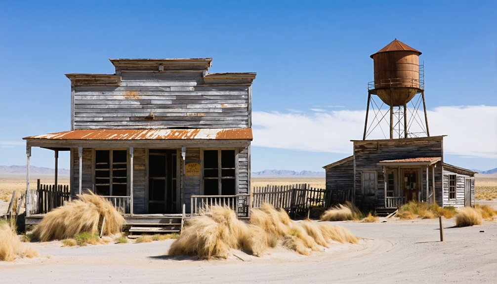
Canebrake is a remote ghost town in Kern County’s Scodie Mountains, named for the dense cane thickets that once dominated the landscape. You’ll find scattered mining remnants from its late 19th century boom period when gold, silver, and borax discoveries fueled its growth. During Prohibition, it became a bootlegging hotspot. Today, nature has reclaimed most structures, offering you an untouched, authentic ghost town experience far from commercialized sites. The whispers of its frontier past await your discovery.
Key Takeaways
- Canebrake emerged in the late 19th century as a mining town in Kern County following gold, silver, and borax discoveries by prospectors like John Searles.
- The ghost town experienced a classic boom-and-bust cycle, declining when local mineral resources were depleted and miners departed for better opportunities.
- Located along Highway 178 in the Scodie Mountains, Canebrake’s remains include weathered mine entrances and crumbling foundations scattered throughout BLM lands.
- During Prohibition, the town became a bootlegging hub with Victor Hugo operating a clandestine distillery and speakeasy in the remote location.
- Unlike more commercialized ghost towns, Canebrake offers an authentic experience with minimal restoration, scattered mining artifacts, and natural reclamation.
The Forgotten Story of Canebrake’s Origins
Nestled within the rugged Scodie Mountains of Kern County, California, Canebrake emerged in the late 19th century as part of America’s fevered westward expansion.
You can trace its name to the dense thickets of cane that once flourished here, remnants of indigenous ecological landscapes that predated European settlement patterns.
When precious metals were discovered in the mineral-rich terrain, prospectors rushed to stake their claims, forever altering Canebrake’s destiny. They were following John Searles’ footsteps, who’d found valuable minerals nearby.
The town’s development followed the classic boom-and-bust cycle that defined the American frontier. The discovery of gold and silver in the area contributed significantly to Canebrake’s initial prosperity.
Before miners arrived, Native Americans had carefully managed these lands through controlled burns and sustainable harvesting.
Their practices maintained the ecological balance that would soon face disruption from hydraulic mining and its devastating ecological impacts. Similar to North Bloomfield, Canebrake’s decline coincided with the ban on hydraulic mining that swept through California’s mining communities.
Mapping Canebrake: Then and Now
You’ll notice Canebrake’s transformation by comparing its historical mining-era maps with today’s sparse geographical representations, revealing the ghost town’s dramatic decline.
The remaining structures—weathered mine entrances, crumbling foundations, and repurposed cabins—stand as silent witnesses against the backdrop of the rugged terrain where Canebrake Creek winds through BLM-protected lands. Historical enthusiasts can access ten topographic maps dated as far back as 1931 that showcase the area’s evolution over time.
When exploring this remote corner of southeastern Kern County, you’re simultaneously traversing its physical geography and walking through layers of history visible in the landscape’s contours, where old mining trails now serve as hiking paths through steep canyon walls. Like many California ghost towns established during the mid-1800s, Canebrake suffered economic decline when local resources were depleted.
Historical Sites Remaining
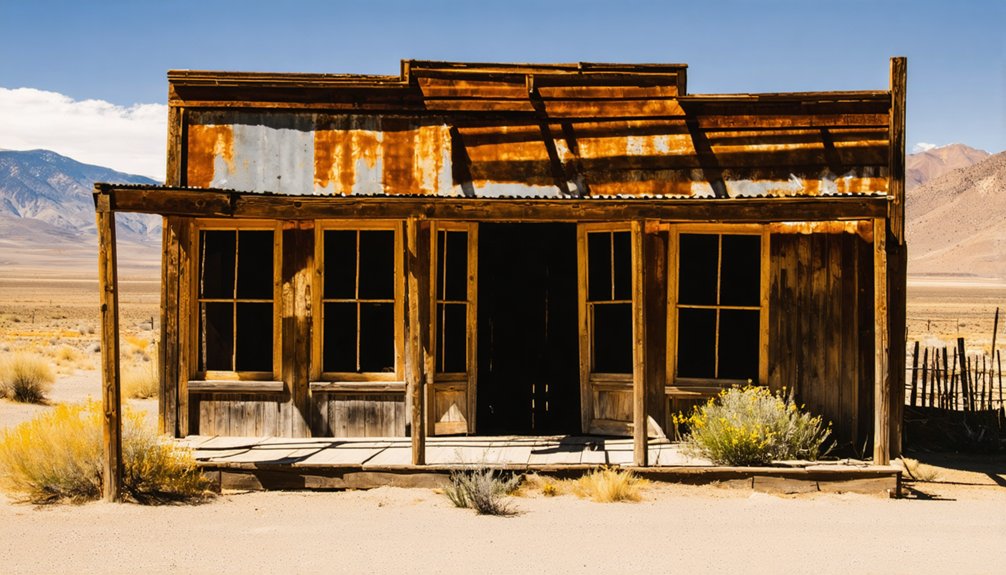
Ghostly remnants of Canebrake’s mining heyday scatter across the rugged Kern County landscape, offering silent testimony to the town’s boom-and-bust cycle.
You’ll find mining artifacts throughout the rocky terrain—abandoned equipment and processing remnants that tell the story of gold, silver, and borax extraction pioneered by prospectors like John Searles.
As you explore, you’ll discover empty streets and structural ruins reclaimed by wild ivy and natural growth.
Unlike tourist-developed ghost towns such as Bodie or Calico, Canebrake remains authentically untouched. The community memories linger in the form of decayed homes and faded pathways that once buzzed with activity. Similar to Falk, the town diminished after economic hardship during the Great Depression affected its primary industry.
The site resembles Dublin Gulch with its unique volcanic structures that provided natural insulation against the harsh desert temperatures.
Use the 24 historic maps available to navigate between old mining pits, tunnel entrances, and house foundations as you walk the same trails miners once traversed.
Geographic Context Exploration
While modern maps barely acknowledge its existence, Canebrake occupies a distinctive geographical niche in southeastern Kern County, where Sierra Nevada foothills gradually surrender to California’s desert landscape.
You’ll find this remote outpost along Highway 178, buffered by expansive BLM lands that preserve its isolation and unique ecological diversity.
Compare historic Pastmaps with today’s satellite imagery and you’ll witness a dramatic transformation.
Where detailed mining claims and bustling trails once dominated, nature has reclaimed much of the terrain.
The geological features—rugged canyons and rocky slopes—remain unchanged, but human presence has diminished considerably.
The town’s footprint has contracted to scattered off-grid dwellings, while old mining roads have evolved into hiking paths connecting Canebrake with neighboring ghost towns in a network of forgotten history. Similar to Bodie State Historic Park, Canebrake offers glimpses into the last days of its residents through preserved structures.
Explorers should remember to leave no trace when visiting this historical site to ensure its preservation for future generations.
Bootlegging and Prohibition-Era Adventures
During Prohibition, the sleepy town of Canebrake transformed into a hotbed of illicit activity, with Victor Hugo’s clandestine distillery and speakeasy operation tucked away in the protective embrace of the South Fork Valley.
Canebrake’s quiet façade masked a thriving underground empire where bootleggers found sanctuary from Prohibition’s reach.
If you’d visited during the 1920s, you’d have found sophisticated bootlegging methods at work. Hugo capitalized on Canebrake’s strategic location along Route 178, using the remote geography to hide his moonshine production from authorities. The rugged hills surrounding the area provided ideal cover for hidden distilleries that evaded law enforcement for years. The desert landscape of this small Kern County community further complicated surveillance efforts by prohibition agents.
You might’ve encountered buzzer systems warning of approaching lawmen or witnessed smugglers maneuvering county lines to escape jurisdiction—common prohibition challenges for enforcement.
The speakeasy became a secret social hub, where jazz might accompany your illegal drink.
While Sheriff Becker ran corruption rackets in nearby counties, Canebrake’s operations contributed to a shadow economy that sustained rural communities during America’s “noble experiment” in temperance.
Natural Surroundings: The Canebrake Ecological Reserve
Today’s Canebrake bears little resemblance to its prohibition-era persona, having transformed into a 6,700-acre ecological sanctuary nestled within Kern County’s South Fork Valley.
You’ll find this diverse reserve about ten miles east of Lake Isabella, where natural landscapes flourish across several units including Bloomfield Ranch and Scodie Ranch.
The reserve’s impressive habitat types range from riparian corridors to Joshua tree woodlands, supporting a wildlife diversity that would astonish even the most seasoned naturalist.
Hundreds of bird species soar overhead, while the rare southwestern pond turtle makes its home in wetland areas.
As you hike the designated trails, you’re walking through an essential wildlife corridor connecting the Sierra Nevada to California’s Central Valley—a living evidence of conservation efforts that began in 1994.
Exploring What Remains: A Visitor’s Guide

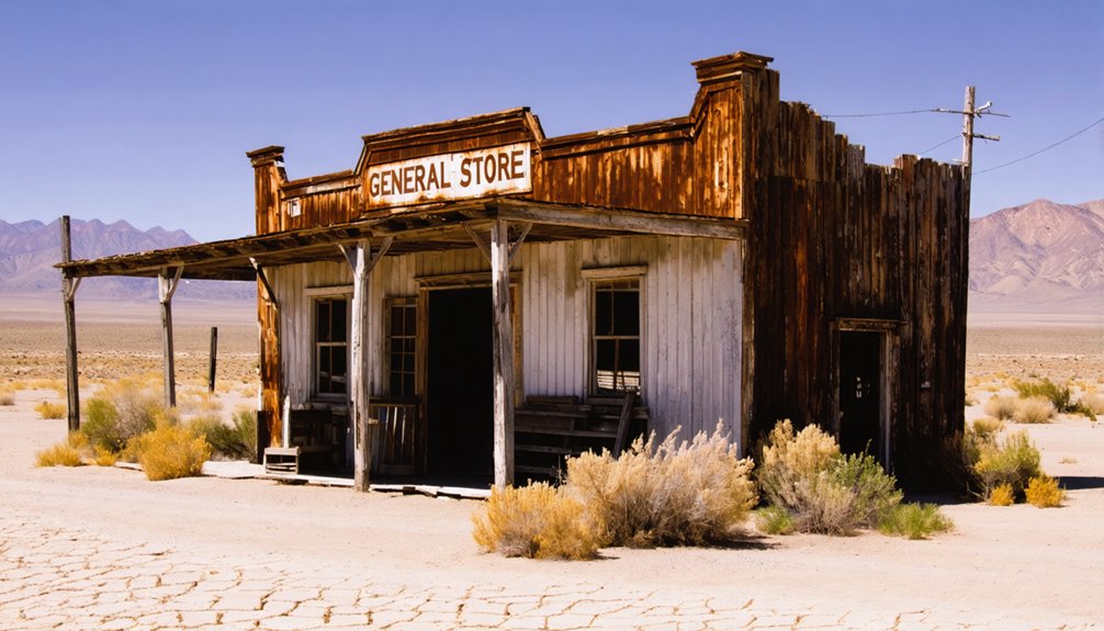
Those venturing to Canebrake in search of a Hollywood-style ghost town might initially feel disappointed, as this remote outpost offers something far more authentic than its commercialized counterparts.
Unlike Bodie or Calico, you’ll find no restored buildings or interpretive signage—just scattered mining remnants and weathered structures embedded in rocky terrain.
Visitor safety demands preparation: bring water, food, and emergency supplies, as you’ll be truly isolated once you leave pavement.
Cell reception is spotty, so navigate cautiously through the rugged landscape. Local legends speak of mining fortunes and frontier resilience, stories best absorbed while watching sunrise over Walker Pass.
For self-sufficient explorers seeking freedom from commercial distractions, Canebrake delivers raw history and wilderness solitude that curated ghost towns can’t match.
Mining and Logging: The Economic Foundation
The late 19th century transformed Canebrake from barren wilderness into a bustling frontier economy when prospectors unearthed promising veins of gold and silver within the jagged terrain of Kern County.
You’ll find evidence of primitive mining techniques in the remnants of arrastras—stone grinding mills that once processed ore yielding about one ounce of gold per ton.
Beyond gold, the area’s borax deposits attracted influential miners like John Searles, diversifying the economic landscape.
As you explore, you’ll notice how logging impacts remain visible—timber harvesting supported mine shaft construction and provided essential building materials for camps.
When mining operations expanded in the early 1900s with the Magnolia claims, so did the supportive infrastructure of trails and facilities, all dependent on local lumber resources.
From Boom to Abandonment: Tracing Canebrake’s Decline
Despite flourishing briefly as a promising frontier settlement, Canebrake’s glory days wouldn’t last beyond the initial mineral rush that had drawn optimistic prospectors to this remote corner of Kern County.
Like shooting stars across the frontier sky, Canebrake blazed brilliantly before fading when the precious metals ran dry.
Like many boomtowns caught in merciless economic cycles, Canebrake’s descent followed a familiar pattern.
You can trace the town’s decline through:
- The exhaustion of easily accessible gold and silver deposits
- The exodus of miners seeking fortune elsewhere
- Abandoned infrastructure falling into disrepair
- The gradual dissolution of community resilience as population dwindled
What you’ll find today are whispered remnants of a once-vibrant settlement.
Buildings returned to the earth, with minimal preservation efforts marking their existence.
The landscape now stands as a haunting reflection of the transient nature of resource-dependent communities and the freedom sought by those who briefly called this place home.
Comparing Canebrake to Other Kern County Ghost Towns
While Canebrake remains one of Kern County’s more enigmatic ghost towns, the region boasts a remarkable collection of abandoned settlements that tell distinct chapters of California’s frontier history.
Unlike the railroad-driven Caliente and Bealville along Highway 58, or the mining boomtowns of Randsburg and Johannesburg near Route 395, Canebrake offers minimal structural remains and far fewer visitors.
The Kern comparison reveals a stark contrast in accessibility—Canebrake’s remote location requires determination to reach, while Silver City Ghost Town provides a curated experience of relocated historic buildings for casual tourists.
Where Randsburg maintains a living presence with museums and businesses, Canebrake contrast is evident in its lack of commercial development.
You’ll find Canebrake’s value lies in its untouched authenticity rather than preserved landmarks or tourist amenities.
Photography Tips for Capturing Canebrake’s Haunting Beauty
Capturing Canebrake’s atmospheric desolation requires thoughtful preparation and a keen eye for the subtle beauty hidden within its weathered remains.
The ghost town’s crumbling structures and scattered artifacts tell stories that your camera can preserve with the right approach. Pack your wide-angle lens, tripod, and cleaning kit before venturing into this forgotten corner of Kern County.
- Schedule your shoot during golden hour when the low-angle sunlight creates dramatic shadows across deteriorating facades.
- Experiment with composition tips like framing doorways against distant mountains for depth and context.
- Use lighting techniques such as bracketing exposures to handle the harsh contrast between sun-bleached exteriors and shadowy interiors.
- Focus on telling a complete story by photographing both architectural features and intimate details like abandoned personal possessions.
Frequently Asked Questions
Are There Any Supernatural Legends or Ghost Stories About Canebrake?
You won’t find documented ghost sightings or haunted history specific to Canebrake. Unlike other Kern County ghost towns, this remote mining settlement hasn’t generated well-substantiated supernatural legends in historical records.
What Indigenous Tribes Originally Inhabited the Canebrake Area?
Where ancestors walked, wisdom remains. You’ll find the Tübatulabal, Yokuts, Kawaiisu, and Chemehuevi Native tribes originally inhabited Canebrake. Their historical impact endures despite displacement from traditional lands.
Can You Legally Collect Artifacts From Canebrake’s Abandoned Sites?
No, you can’t legally collect artifacts from abandoned sites. Artifact collection laws and historical preservation guidelines prohibit removal from public lands and restrict private land collection regardless of a site’s abandoned status.
What Happened to Victor Hugo After His Bootlegging Days?
Victor Hugo’s legacy remains shrouded in mystery. No historical records trace his fate after his bootlegging operations ended. You’ll find only silence where his story should continue—his disappearance as complete as his spirits.
Is Canebrake on Private Property or Accessible to the Public?
You’ll find a fascinating mix of property ownership in Canebrake. While private homes dot the landscape, public access is generally available as BLM land surrounds most of the ghost town settlement.
References
- https://www.youtube.com/watch?v=fSt6eDTslnQ
- https://www.californist.com/articles/interesting-california-ghost-towns
- https://dornsife.usc.edu/magazine/echoes-in-the-dust/
- https://en.wikipedia.org/wiki/Canebrake
- https://pastmaps.com/explore/us/california/san-diego-county/canebrake/hiking-exploration
- https://www.youtube.com/shorts/TpoH-g6yAAA
- https://www.camp-california.com/california-ghost-towns/
- https://www.youtube.com/watch?v=OD9M6MP6RRU
- https://www.atlasobscura.com/itineraries/the-wildest-west
- https://en.wikipedia.org/wiki/List_of_ghost_towns_in_California


