You’ll find Carwye, an abandoned Black Hills gold rush settlement, at 44.222208°N, -103.421298°W in western Meade County, South Dakota. The town emerged during the 1875-1876 mining boom, featuring Victorian Gothic architecture amid industrial ruins. Today, you’ll need a high-clearance vehicle to access the site’s scattered remains, including a one-room schoolhouse, chapel, and banker’s mansion. The ghost town’s rich history intertwines with the region’s controversial gold rush era and Native American treaty violations.
Key Takeaways
- Carwye emerged during the Black Hills Gold Rush of 1875-1876 as a mining support town in western Meade County, South Dakota.
- The town is located at coordinates 44.222208°N, -103.421298°W, requiring high-clearance vehicles for access through unpaved rural roads.
- Victorian Gothic architecture, including a banker’s home and industrial ruins, remains as evidence of the town’s former prosperity.
- The settlement included essential services like a post office, general store, one-room schoolhouse, and chapel for early residents.
- Mining operations, railroad development, and eventual mine closures due to rising costs led to the town’s abandonment.
The Rise and Fall of a Black Hills Settlement
While the Black Hills were legally protected Sioux territory under both the 1851 and 1868 Fort Laramie Treaties, the discovery of gold in 1874 during Custer’s expedition sparked an illegal rush of settlers that would transform the region.
Despite treaties protecting Sioux lands, the 1874 discovery of Black Hills gold unleashed an unstoppable flood of fortune-seeking settlers.
You can trace Carwye’s history to this pivotal moment when prospectors flooded the Black Hills, defying treaty rights in search of riches. The Treaty of Fort Laramie recognized annual payments of $50,000 to the Sioux Nation for their territory, though the U.S. Senate later reduced this to $10,000 after just one year. The U.S. government’s subsequent seizure of the land through the controversial 1877 Manypenny Agreement opened the door for permanent settlement.
Like many Black Hills communities, Carwye emerged as a mining support town during this boom period, its fortunes tied directly to the success of local gold extraction. The earliest mining operations focused on the Deadwood Formation, which contained the region’s richest gold deposits.
However, the mining legacy wouldn’t sustain the town forever. As ore yields declined and the automotive age changed transportation patterns, Carwye’s population dwindled until the town was eventually abandoned.
Location and Geographic Features
You’ll find Carwye tucked away in western Meade County, South Dakota at coordinates 44.222208°N, -103.421298°W, where it once served as a strategic point along the Homestake Mining Company’s narrow gauge railroad.
The ghost town‘s terrain reflects its position in the Great Plains-Black Hills junction zone, featuring gently rolling hills and semi-arid prairie vegetation typical of the region’s ghost town network. Like one remaining elevator in Awanka, the ruins of mining equipment still dot the landscape. Patient researchers and explorers often rely on old newspaper records to accurately locate and identify such ghost towns.
Among these abandoned sites in South Dakota, stories of past inhabitants linger in the air, waiting to be uncovered by curious travelers. Each site offers a unique glimpse into the region’s history, revealing the challenges faced by early settlers and the eventual decline of these once-thriving communities. As explorers traverse the remnants of old buildings and infrastructure, they contribute to the ongoing narrative of the Great Plains’ rich cultural tapestry.
The site’s remote location and challenging access via unpaved rural roads demonstrates its isolation within the sparsely populated Black Hills area, where it shares similar geographic attributes with other abandoned mining and lumber settlements.
Regional Positioning and Access
Carwye sits at approximately 44.2222°N latitude and -103.4213°W longitude in western South Dakota’s Meade County, nestled within the historically rich Black Hills region.
For ghost town exploration enthusiasts, you’ll need to navigate the area’s network of unpaved forest service roads, as there’s no active rail service or public transportation to the site.
The surrounding regional history comes alive through nearby abandoned settlements like Cold Springs, Crook City, and Dewey, all accessible via existing trails. Similar to other ghost town sites, Carwye shows various states of disrepair and abandonment.
You’ll want a high-clearance or all-terrain vehicle, as the semi-arid terrain and seasonal weather can make access challenging.
While exploring, remember you’re in an area that may include National Forest Service lands, so respect private property rights and conservation policies during your visit. Always carry essential supplies and gear for a safe exploration experience.
Topographical and Environmental Features
Nestled along the eastern edge of the Black Hills at approximately 3,200 feet elevation, this former settlement occupies rolling terrain characteristic of western South Dakota’s shift zone between mountains and plains.
You’ll find vegetation patterns evolving from mixed prairie grasses to scattered ponderosa pines, while seasonal creeks carved subtle valleys through the landscape’s sandy loam soil. The area’s hydrological challenges, including limited water availability and periodic drought, played a vital role in the town’s eventual abandonment.
- Semi-arid continental climate delivers 15-20 inches of annual precipitation, with most rainfall occurring in late spring
- Historical mining and railroad activities left visible scars across the terrain, including linear depressions and terraced hillsides
- Local streams connect to the broader Cheyenne River watershed, though their seasonal flow proved unreliable for sustained settlement
Surrounding Ghost Town Network
The broader Black Hills region surrounding Carwye contains a rich network of over 600 ghost towns, each marking the remnants of mining camps, post offices, and small communities that once thrived in this rugged landscape.
You’ll discover abandoned structures in nearby towns like Alta, Apex, Argyle, and Bakerville, with some sites accessible via historic routes like Crook City Road and the Mickelson Trailhead.
The historical significance of these settlements is evident in places like Carbonate, where you’ll find a cemetery and mining structures about four miles west of Maitland. The town’s original prosperity came from the discovery of valuable carbonate ore deposits that attracted hundreds of miners to the area.
While exploring these sites, you’ll notice how they developed along ore-rich veins and transportation routes, though many locations require local knowledge to identify due to shifting names and vanished landmarks.
Mining Heritage and Economic Drivers
You’ll find Carwye’s early economic foundation closely tied to the Black Hills Gold Rush of 1875-1876, which sparked regional mining development using stamp mills and amalgamation processes similar to those at the nearby Jones and Pinney Mill.
Early miners initially worked the area using picks and shovels before transitioning to more advanced methods.
The area had been sacred to Native American tribes for thousands of years before mining operations began.
The town’s mining operations contributed to South Dakota’s impressive 40+ million troy ounces of gold production, though most local claims were depleted by the early 1900s as mining activity concentrated around Lead and Deadwood.
Rail connections through Carwye supported both mining equipment transport and ore shipments, playing a crucial role in the town’s brief but significant mining period.
Gold Rush Economic Impact
During the Black Hills gold rush, three pivotal discoveries transformed Carwye’s economic landscape – the initial French Creek findings in 1874, the widespread placer claims of 1876, and the game-changing Homestake deposit near Lead.
As gold mining operations expanded, you’d have witnessed rapid economic development throughout the region, with Homestake Mine alone producing over 40 million ounces of gold during its 125-year run. The mine’s success made it responsible for generating 10% of global gold during its operation.
- The rush sparked explosive growth in supporting industries, from equipment suppliers to service businesses.
- Mining operations funded critical infrastructure development, including the 1878 Jones and Pinney Stamp Mill.
- Economic consequences rippled beyond mining, creating concentrated wealth among investors while violating Native American treaty rights.
The economic impact reshaped the entire Black Hills region, though rising costs eventually led to widespread mine closures, except for Homestake’s remarkable longevity until 2001.
Railroad Transportation Networks
Railroad networks fundamentally shaped Carwye’s development, paralleling the broader transformation of South Dakota’s mining landscape after 1880.
You’ll find Carwye’s story mirrors the railroad expansion that reshaped southeastern Dakota Territory, as rail companies strategically established towns along their routes. They’d control everything from town placement to lot sales through subsidiary land companies.
Like many mining settlements, Carwye relied on rail connections for shipping minerals, coal, and uranium to broader markets. The depot served as your lifeline, handling freight, mail, and telegrams while grain elevators and warehouses lined the sidings.
This economic transformation lasted until post-World War II, when automobiles and trucks gained dominance.
Today, Carwye stands abandoned, its ghost town status a direct result of rail line abandonment – a fate shared by numerous South Dakota communities that once thrived along the tracks.
Mining Equipment and Operations
Three major technological innovations transformed Carwye’s mining operations between 1880-1975, starting with the shift from animal labor to compressed air locomotives in the 1920s.
Mining technology evolved rapidly as shaft depths increased from 900 feet to an ambitious 8,000 feet, requiring sophisticated ventilation systems that moved 500,000 cubic feet of air per minute.
You’ll find that ore extraction methods progressed from basic mechanical crushing to advanced chemical processes, with Merrill’s cyanidation technique boosting gold recovery rates to 94%.
- Primary crushing advanced from manual sledgehammers to powered jaw and gyratory crushers
- Underground infrastructure expanded with extensive drifts, winzes, and ventilation raises
- Chemical processing methods adapted to specific ore types, using both wet and dry crushing techniques
Life in Early Carwye
Life in early Carwye reflected typical Great Plains settlement patterns, as pioneers arrived by wagon trains throughout the 1860s and 1870s seeking fertile farmland near the newly established railroad.
Settler experiences centered around agriculture, with families cultivating wheat and corn while raising livestock for sustenance and trade. You’d find skilled tradesmen among the early arrivals, contributing their expertise to the town’s development.
Pioneer families worked the soil and raised animals while craftsmen built the foundations of early frontier communities.
Community bonds formed through social gatherings at the local church and community hall, where dances and Fourth of July celebrations brought neighbors together.
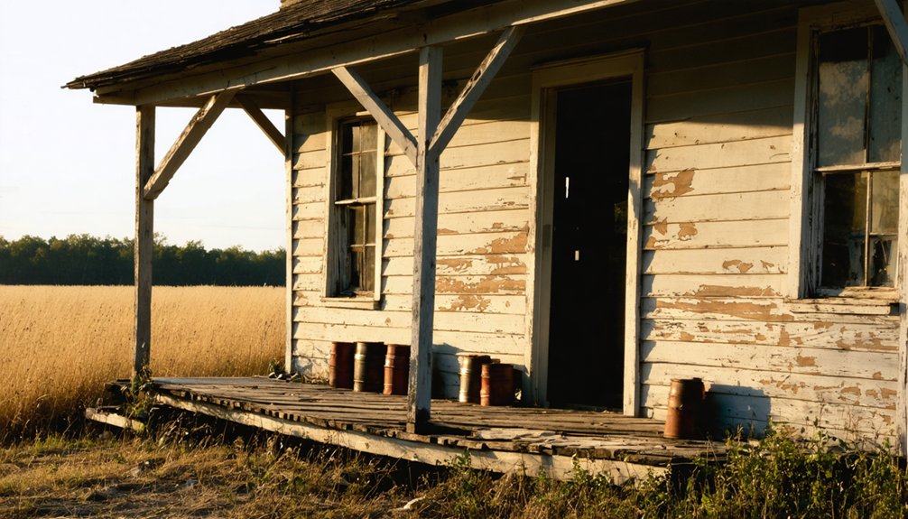
Residents established essential services quickly, including a post office and general store. You’d see wide main streets lined with wooden sidewalks, while the railroad depot served as the town’s lifeline for shipping crops and receiving supplies.
Architectural Remains and Historical Sites
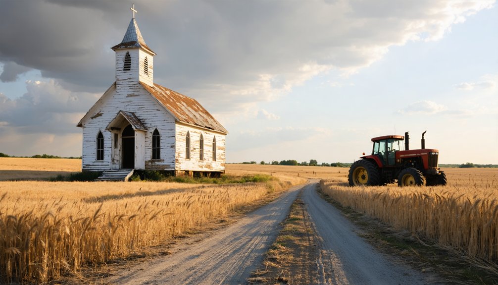
While many Black Hills ghost towns showcase mining remnants, Carwye’s architectural legacy features distinctive Victorian Gothic elements amid its industrial ruins.
You’ll find this architectural preservation evident in the ornate stone buildings, including banks and recreational facilities that once served the mining community. The historical significance of Carwye’s remains extends beyond its mining structures, with transportation heritage visible through abandoned railroad grades and stage station ruins.
- Victorian Gothic banker’s home, reminiscent of those in nearby Cascade, stands as evidence of the town’s former prosperity
- Elevated tramways and ore processing facilities highlight the integration of industrial architecture with community structures
- One-room schoolhouse and chapel remains demonstrate the town’s commitment to education and spiritual life
Legends and Local Stories
Beyond the physical remnants of Carwye’s Victorian Gothic architecture lies a rich tapestry of supernatural lore and local folklore.
You’ll find the town’s most chilling tales connected to nearby Sica Hollow, named by Dakota Sioux to mean “evil.” The area’s springs run red, which the Sioux believed contained the flesh and blood of their ancestors. Since the 1970s, locals have reported half-man-half-beast creatures and mysterious disappearances in these haunted woods.
Like the feared Spirit Mound near Vermillion, where “little devils” once guarded against intruders with magic arrows, Carwye’s supernatural reputation stems from its Native American heritage.
This dark history intertwines with mining-era tragedies, creating a complex web of paranormal activity that continues to draw curious visitors seeking encounters with the unexplained.
Accessing and Exploring the Ghost Town Today
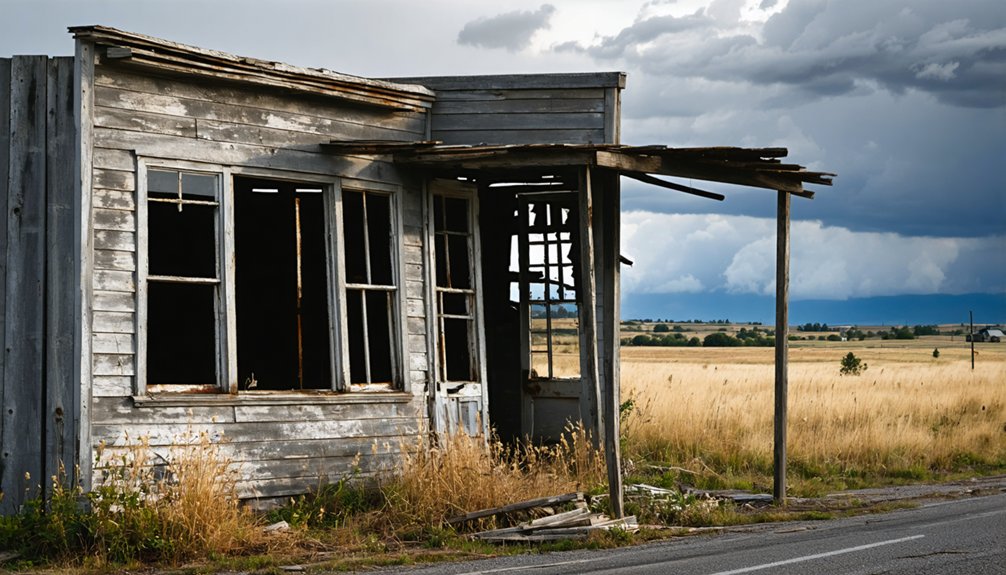
Despite its historical significance, accessing Carwye today presents unique challenges since the ghost town has reverted to a barren site at coordinates 44.222208, -103.421298 in Meade County.
You’ll need to navigate forest service roads and former mining routes to reach the location, which sits at the end of what was once a Homestake Mining Company narrow gauge line.
- Verify property ownership before exploring, as the site borders both Forest Service and private lands
- Pack essential gear including water, navigation tools, and sturdy footwear for potentially rough terrain
- Follow established access routes and stick to visible paths to prevent further site degradation
While minimal remains exist at Carwye, visitor guidelines recommend parking in designated areas and hiking to explore any visible foundations or traces of the former settlement.
Frequently Asked Questions
What Was the Total Population of Carwye at Its Peak?
Based on Carwye’s demographics and limited economy as a railroad settlement, you’ll find the peak population reached between 50-75 residents before the town’s eventual abandonment following railroad removal.
Were There Any Notable Crimes or Murders in Carwye’s History?
While unsolved mysteries may intrigue you, historical records don’t reveal any documented crimes or murders in this settlement. You won’t find evidence of notable criminal activity in available archives.
Did Any Famous Historical Figures Ever Visit or Live in Carwye?
You won’t find records of any famous visitors or documented historical figures in this location. While nearby Deadwood attracted well-known personalities like Wild Bill Hickok, no notable individuals are linked to this settlement.
What Was the Average Price of Property in Carwye During Its Heyday?
While you’d find no exact records of average property values in Carwye’s peak, similar Black Hills mining towns saw residential lots selling between $50-500, varying with the town’s railroad and mining economy.
Did Native American Tribes Have Settlements in the Carwye Area Before Mining?
You’d think miners were first, but archaeological evidence shows Native American settlements existed there long before. Tribal artifacts like arrowheads and tools prove Dakota and Paleo-Indian tribes inhabited the region seasonally.
References
- https://www.youtube.com/watch?v=Glucs_Rq8Xs
- https://www.sdpb.org/rural-life-and-history/2023-08-21/some-black-hills-ghost-towns-and-their-origins
- https://www.youtube.com/watch?v=_0WNYsFLSLA
- https://www.sdhspress.com/journal/south-dakota-history-2-2/some-black-hills-ghost-towns-and-their-origins/vol-02-no-2-some-black-hills-ghost-towns-and-their-origins.pdf
- https://core.ac.uk/download/pdf/345016075.pdf
- https://www.blackhillsbadlands.com/blog/post/old-west-legends-mines-ghost-towns-route-reimagined/
- https://icatchshadows.com/okaton-and-cottonwood-a-photographic-visit-to-two-south-dakota-ghost-towns/
- https://en.wikipedia.org/wiki/List_of_ghost_towns_in_South_Dakota
- https://explore.digitalsd.org/digital/collection/WPGhosttown/id/6824/
- https://aberdeenmag.com/2019/01/the-ghost-towns-of-brown-county/


