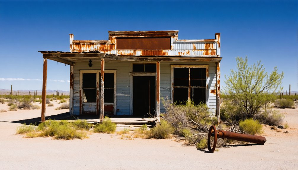
Chaparral emerged during Arizona’s 1895 mineral fever, thriving briefly until 1916 when insufficient ore quality and falling metal prices forced abandonment. You’ll find this ghost town largely reclaimed by the Yavapai County desert, with minimal intact structures compared to other abandoned settlements. The community once featured a cultural fusion of Anglo-American and Mexican miners living in rudimentary cabins, with the post office serving as their essential connection to civilization. Its obscure location reveals the classic boom-and-bust pattern of frontier mining towns.
Key Takeaways
- Chaparral was established in 1895 during Arizona’s mining boom, focusing on gold, silver, and copper extraction until abandonment by 1916.
- The ghost town featured a culturally diverse community with Anglo-American and Mexican influences, centered around mining operations and basic commercial establishments.
- Few visible remnants exist today as the desert has reclaimed most structures, making Chaparral more difficult to locate than other Arizona ghost towns.
- Mail delivery via Star Route contractors on horseback provided vital communication links for the isolated mining community.
- Specialized maps, GPS coordinates, and research of topographical features are necessary for modern explorers to locate this remote ghost town site.
The Rise and Fall of Chaparral (1895-1918)
As the nineteenth century drew to a close, the small settlement of Chaparral emerged from Arizona’s rugged landscape, born of the same mineral fever that had spawned dozens of mining communities across the southwestern frontier.
You’d find modest gold and silver operations driving community dynamics here, with miners facing isolation due to limited transportation infrastructure unlike their counterparts in Bisbee or Jerome.
Chaparral’s peak occurred between 1900-1908, when basic mining techniques extracted precious metals supplemented by copper.
Yet the town’s destiny was sealed by insufficient ore quality, declining metal prices, and lack of rail connections. Like many mining operations of the era, Chaparral miners relied on heavy ore wagons to transport materials across the difficult terrain.
The ease of filing mining claims under the 1872 Mining Law allowed prospectors to quickly establish operations in Chaparral despite its remote location.
By 1916, the mines stood exhausted, and World War I’s copper demand couldn’t revive Chaparral’s fortunes.
The population scattered, seeking opportunity elsewhere as the settlement slipped into abandonment.
Life in a Late 19th Century Mining Community
While the lure of mineral wealth drove Chaparral’s establishment, daily existence in this isolated mining community proved considerably more complex than mere fortune-seeking.
You’d have found yourself amid a cultural fusion of Anglo-American and Mexican influences, as laborers recruited from Sonora and the Southwest formed the backbone of copper mining operations. Many Hispanic smelter men utilized adobe smelters for copper processing, bringing techniques that significantly influenced early mining practices in Arizona.
Housing consisted primarily of rudimentary cabins and tents, with general stores and saloons serving as social hubs in an environment marked by scarcity and vigilance against Apache raids.
Labor struggles emerged as harsh conditions, low wages, and environmental hazards became commonplace. Mexican workers operated smelters while enduring racial tensions that occasionally erupted in nearby white miners’ strikes.
The chaparral landscape itself shaped community life, with limited water access and wildfire risks compounding the challenges of this remote outpost. Like many mining towns in Arizona, Chaparral was ultimately abandoned as the ore deposits depleted, leaving behind only remnants of its once-bustling existence.
Postal Service: Lifeline of the Frontier Town
Beyond the hardships of daily mining life, a system of connection and communication knitted Chaparral into the broader American tapestry. The post office, typically housed within the general store, represented more than just mail delivery—it forged community identity in this isolated mining settlement.
Star Route contractors, often from pioneer families, navigated treacherous terrain on horseback or mule to deliver precious correspondence. These mail contracts provided essential employment while ensuring Chaparral remained connected to distant family and commercial opportunities. Following the establishment of Arizona’s early mail routes, contractors like Zeckendorff and Udall became instrumental in creating postal infrastructure that served remote mining camps like Chaparral.
You would have witnessed mail carriers battling harsh elements, sometimes improving roads at their own expense to maintain service. The arrival of mail meant news from home, business opportunities, and a lifeline to civilization that transformed Chaparral from a remote outpost to a place of belonging and purpose. Many of these frontier post offices documented their daily operations in official postal ledgers, creating valuable records for both postal historians and genealogists researching Arizona’s territorial period.
When you arrive at Chaparral today, you’ll encounter a site largely reclaimed by desert, with scattered foundations and metal fragments barely visible among creeping vegetation.
Finding your way through this ghost town presents considerable challenges without specialized maps or GPS coordinates, as natural erosion has obscured former streets and building locations. Unlike Vulture City with its 16 original buildings from the 1800s still standing, Chaparral offers almost no intact structures.
As you explore the ghost town history in Arizona, you’ll find remnants of a once-thriving community, now claimed by the desert. Each abandoned building tells a story of its former inhabitants, offering a glimpse into life during a bustling mining era. Visitors often leave with a sense of nostalgia and wonder about the lives that were once intertwined in these dusty streets.
Your photography efforts will face unique obstacles here, where harsh lighting conditions, minimal standing structures, and the subtle nature of remaining artifacts demand technical skill to capture meaningful images of this vanished frontier community. The site echoes the pattern of many Arizona ghost towns that were abandoned during the Great Depression when mining operations became economically unfeasible.
Finding Without Maps
How does one locate a place that has almost completely vanished from the landscape? When seeking Chaparral, you’ll need to employ specialized exploration techniques rather than traditional wayfinding.
Begin by researching GPS coordinates from ghost town databases or historic mining claims in Yavapai County records. These digital breadcrumbs offer your best starting point for historical navigation.
You can supplement coordinates by identifying topographical features mentioned in archival accounts—ridgelines, dry creek beds, or distinctive rock formations often outlast human structures.
Local historians may provide vital insights about approximate locations, while comparing satellite imagery with old photographs might reveal subtle landscape patterns. Much like the once-thriving Swastika Mine site where few structures remain below the original town, these ghost locations often leave minimal physical traces.
In the absence of physical markers, your success depends on this layered approach, combining technological tools with historical detective work to pinpoint this elusive desert settlement. The experience is quite different from visiting established ghost towns like Goldfield, where attractions and shops have been reconstructed to preserve history.
Nature Reclaims All
The desert’s relentless entropy has systematically erased nearly all physical evidence of Chaparral from Arizona’s landscape.
You’ll find no standing structures or reliable foundations—only scattered rubble, occasional depressions where buildings once stood, and the subtle contours of human disturbance being smoothed by time.
- Cacti and desert shrubs thrust through former foundations, their roots breaking apart the last coherent remnants of human habitation.
- Wind-polished stones and weathered debris blend indistinguishably with natural features, creating a seamless passage to wilderness.
- Seasonal washes carve new channels through the ghost town’s footprint, redistributing artifacts across the desert floor.
Nature’s resilience manifests as an unwitting ecological restoration, reclaiming this once-bustling mining settlement and transforming it back to wilderness—a reflection of the impermanence of human endeavor.
Photography Challenges Abound
For modern photographers seeking to capture Chaparral’s ethereal presence, nature’s reclamation creates a paradoxical subject—simultaneously compelling and frustratingly elusive.
You’ll face harsh lighting conditions across the barren landscape, with direct sunlight creating extreme contrasts that overwhelm sensors. Photography techniques must adapt accordingly—arrive during golden hours when softer light reveals subtle textures in weathered foundations.
Environmental considerations extend beyond mere aesthetics. Your journey involves traversing unmarked, remote routes with specialized gear that withstands dust and heat.
Wide-angle lenses capture the desolation’s breadth, while macro photography reveals nature’s detailed reclamation of human endeavors.
A successful shoot requires careful preparation: stabilized tripods on uneven terrain, weather-sealed equipment, GPS navigation, and abundant water supplies.
Every step demands vigilance—unstable rubble and wildlife pose constant hazards in this hauntingly beautiful wasteland.
Yavapai County’s Forgotten Settlement
Yavapai County’s rugged landscape once harbored the modest settlement of Chaparral, established in 1895 during the region’s mining boom and operating until approximately 1918 when mineral resources became depleted.
You’ll find Chaparral’s brief economic prosperity reflected in its postal service establishment, which served as an essential communication link for miners and their families during the town’s short-lived existence.
The town’s complete abandonment following the closure of its mines represents the classic boom-and-bust cycle that characterized many Western mining settlements, leaving behind only scattered foundations as evidence of its former significance.
Mining Boom and Bust
While most prominent mining settlements in Arizona’s territorial days have been immortalized in history books, Chaparral remains one of Yavapai County’s obscure ghost towns that experienced the classic boom-and-bust cycle characteristic of Western mining communities.
The area’s mines, particularly the Union Mine dating to the late 1860s, flourished through evolving mining techniques from individual prospecting to corporate operations. Economic fluctuations plagued the region, with ore depletion and volatile metal prices forcing mines like United Verde to suspend operations periodically.
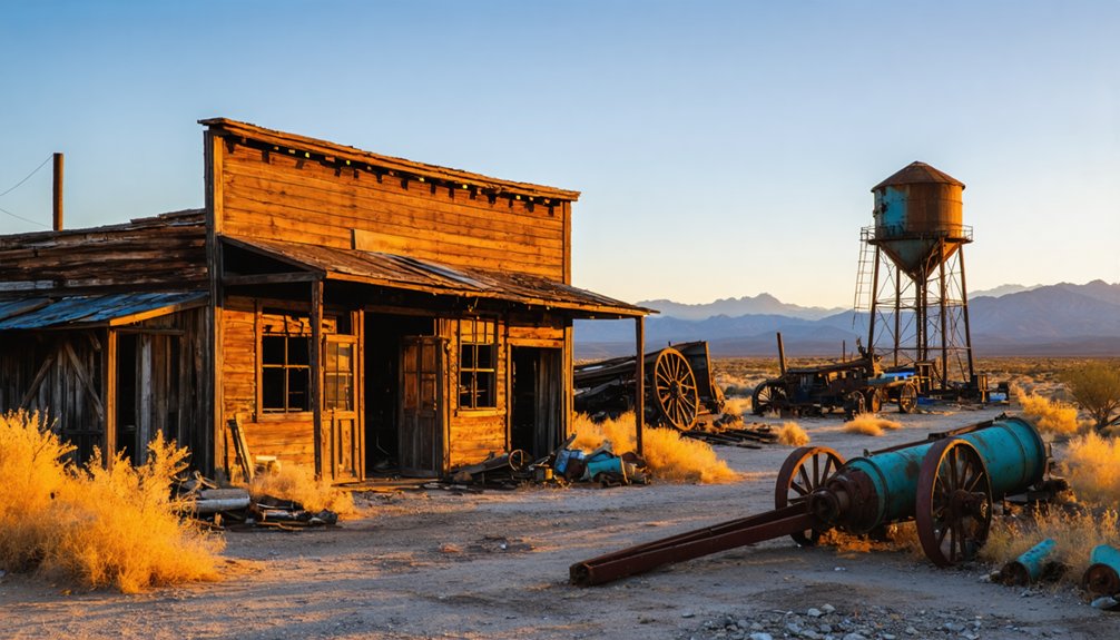
- Weathered wooden headframes still stand sentinel over abandoned mine shafts, slowly surrendering to the elements.
- Crumbling stone foundations mark where miners’ cabins once housed dreamers seeking fortune in Chaparral Gulch.
- Rusted machinery fragments scattered across the landscape serve as industrial artifacts of a bygone prosperity.
Postal Service Timeline
Communication arteries were as essential to frontier settlements as the precious metals that spawned them, and Chaparral’s postal history charts the town’s brief but significant existence in Arizona’s territorial landscape.
In 1877, amid Yavapai County’s mining boom, the Chaparral post office emerged, operating from general stores and private homes.
Star Route contractors braved treacherous postal routes, confronting bandits, monsoons, and rugged terrain to deliver mail via horseback and stagecoach.
You’d have faced weeks of isolation between deliveries, as weather and geographic challenges regularly disrupted these tenuous communication links.
The post office’s closure in 1883 after just six years of operation signaled Chaparral’s decline.
Today, philatelists treasure the rare cancellations from this ephemeral delivery point, preserving evidence of the settlement’s brief connection to the outside world.
Why Mining Towns Disappeared: Economic Patterns
The economic extinction of mining towns like Chaparral followed predictable patterns that plagued resource-dependent communities throughout Arizona’s history.
You’ll recognize how resource depletion triggered devastating unemployment cascades—when minerals vanished, so did livelihoods. This economic fragility stemmed from over-reliance on single industries, creating vulnerability to market fluctuations and technological shifts that reduced labor needs.
- Abandoned company stores with fading signage, their shelves once stocked with mining supplies now collecting dust and desert sand
- Empty miner’s cottages with collapsing roofs and weathered walls, standing as silent monuments to vanished prosperity
- Rusting equipment scattered across barren landscapes, partially reclaimed by cacti and brush
Without economic diversification, towns like Chaparral couldn’t survive the inevitable boom-bust cycle that claimed countless communities across Arizona’s mineral-rich terrain.
Visiting Chaparral: Historical Research and Site Location
Located in the rugged terrain of Yavapai County, Chaparral exists today primarily as archaeological remnants rather than the vibrant mining community it once was.
If you’re planning to visit, you’ll need a 4WD vehicle to navigate the rough access roads. The site is situated within township T13N, Range 1W, near an Ironite factory.
You’ll find little more than rubble and mine ruins marking the historical significance of this once-thriving town that supported the Little Jessie and McCabe mining operations.
For serious research, consult historic maps, postal records, and mining claims to verify exact locations. Exercise caution around current mining activities in the area.
While Chaparral lacks the intact structures found at other ghost towns, it offers a glimpse into Arizona’s boom-and-bust mining history that ended with its post office closure in 1917.
Frequently Asked Questions
Who Was the Longest-Serving Postmaster of Chaparral?
Historical records don’t identify Chaparral’s longest-serving postmaster. Despite the post office’s significance to the mining town’s history (1894-1917), postmaster records remain undocumented in available archival sources you’d typically consult.
Were Any Notable Crimes or Outlaws Associated With Chaparral?
No evidence supports any outlaw legends or crime history connected with Chaparral. You won’t find documented criminal activity there, unlike other Arizona ghost towns that developed notorious reputations during frontier times.
What Specific Minerals or Metals Were Mined Near Chaparral?
Like prospectors chasing a desert mirage, you’ll find gold mining was primary in Chaparral’s history. The area yielded gold, copper, and arsenopyrite, with possible silver extraction from associated sulfide minerals.
Did Chaparral Have Any Schools or Churches During Its Existence?
You’ll find no evidence of schools or churches in Chaparral’s brief history. The mining town’s education history and religious significance remain undocumented in available historical records from 1894-1917.
Were Any Films or Books Set in or About Chaparral?
Like a celluloid treasure trove, your search for film adaptations and literary references will lead you to “The High Chaparral” TV series rather than actual works about the ghost town itself.
References
- https://azgw.org/yavapai/ghosttowns.html
- https://freepages.history.rootsweb.com/~gtusa/ontheroad/us80a.htm
- https://www.reviewjournal.com/uncategorized/a-friendly-ghost-town-jerome-ariz/
- https://kids.kiddle.co/List_of_ghost_towns_in_Arizona
- https://en.wikipedia.org/wiki/List_of_ghost_towns_in_Arizona
- http://www.thehighchaparral.com/library3.htm
- https://www.ghosttowns.com/states/az/azalphabetical.html
- https://www.nps.gov/parkhistory/online_books/sagu/hrs/hrs3.htm
- https://digitalrepository.unm.edu/cgi/viewcontent.cgi?article=2351&context=nmhr
- https://westernmininghistory.com/1328/a-collection-of-arizona-mining-photos/


