You’ll find Chilito ghost town in Arizona’s Dripping Spring Mountains, where Jake Schneider discovered copper deposits in 1885. This former mining community thrived with up to 200 residents, featuring a post office, general stores, and saloons during its peak operations. The town supported active mining until 1962, extracting copper, gold, silver, and molybdenum. Today, you can explore remnants like the wooden guard shack and dynamite vault, while uncovering layers of Arizona’s rich mining heritage.
Key Takeaways
- Chilito was a copper mining town in Arizona’s Banner Mining District, discovered by Jake Schneider in 1885 and operated until 1962.
- The ghost town reached a peak population of 200 residents and included general stores, saloons, boardinghouses, and a post office.
- Located at coordinates 33.0667307°N, -110.7970513°W, Chilito’s remains include a wooden guard shack and dynamite storage vault.
- The London Arizona Mine extracted 15,000 tons of copper ore, with operations producing copper, gold, silver, and molybdenum.
- Access requires a 4×4 vehicle with high clearance, with best visiting conditions during dry seasons from October through April.
The Rise of a Mining Community
When Jake Schneider discovered copper deposits in Gila County‘s Banner Mining District in 1885, he laid the foundation for what would become the mining community of Chilito, Arizona.
You’ll find this small but significant settlement perched at 3,799 feet, where community growth centered around the porphyry copper deposits of Schneider Hill.
The mine’s skarn-related deposits produced high-grade sulfide ore in discontinuous replacement bodies throughout the area.
As silver’s prominence faded after the 1893 Sherman Silver Purchase Act repeal, Chilito’s copper resources became increasingly valuable.
The site’s development from initial prospecting claims to structured mining operations reflected the broader copper boom sweeping across Arizona.
The Schneider Mine became the heart of local mining culture, with both underground and surface operations supporting the community.
You can trace Chilito’s evolution through twenty claims in the National Forest lands, where miners extracted copper, gold, silver, and molybdenum.
Mining operations continued until last production in 1962, marking the end of Chilito’s active mining era.
Life in Early 1900s Chilito
Despite its geographic isolation in the rugged Dripping Spring Mountains, Chilito emerged as a determined mining settlement in the early 1900s.
You’d find early settlers battling challenging terrain at 3,799 feet elevation, where they established operations near the Gila River in an isolated canyon. Community dynamics revolved around the underground mining network, with workers maneuvering through the 1,800-foot tunnel and storing explosives in what would later become a preserved dynamite vault.
Life wasn’t easy – you’d see companies struggle with insufficient capital and unstable copper prices, while the remote location made transporting supplies particularly difficult. The London Arizona Mine produced significant yields during this period, extracting 15,000 tons of copper ore.
The mining community persisted through intermittent operations, focusing on extracting copper from surface-cropping skarns and shipping high-lime fluxing ore to the Hayden smelter when economic conditions allowed.
Mining Operations and Mineral Wealth
The discovery of Chilito’s mineral wealth by Jake Schneider in 1885 launched nearly eight decades of mining operations in Arizona’s Banner District. The site’s potential for mineral extraction drew various operators, including Gordon Wainwright and George B. Chittenden, who developed 20 claims across the area. The mine’s unique Apache group sediments influenced the ore control and mineralization patterns.
You’ll find evidence of diverse mining techniques through:
- Surface quarrying at Chilito Quarry, focusing on copper and crushed stone
- Underground network of adits spanning multiple elevations from 2,999 to 3,799 feet
- Combined surface-underground operations that yielded copper, gold, silver, and molybdenum
The porphyry copper and skarn-related deposits proved profitable until 1962, when operations ceased. Located at 2,999 feet elevation, the quarry operations focused primarily on extracting copper and crushed stone resources.
Today, remnants of this industrial heritage include a wooden guard shack and dynamite storage vault within National Forest land.
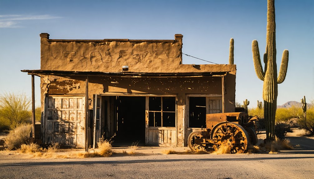
Notable Buildings and Structures
At the former Chilito mining camp, you’ll find remnants of essential structures that supported its peak population of 200 residents, including preserved wooden guard checkpoints and mine-support facilities.
The site retains visible evidence of commercial buildings like general stores, saloons, and boardinghouses that once served the London-Arizona Mine operations. Like many ghost town sites, these buildings showcase Arizona’s rich mining heritage.
Located in the historic Banner Mining District, this settlement played a crucial role in Arizona’s mineral production history.
The most notable remaining features include an intact dynamite storage vault, scattered concrete and wooden foundations, and mechanical remnants like chutes and lift mechanisms at 3,799 feet elevation.
Remaining Mine Site Structures
Standing as evidence to Chilito’s mining heritage, several key structures remain visible at the former mine site in Gila County, Arizona.
Despite minimal preservation efforts, these abandoned structures tell the story of copper mining operations that spanned from 1885 to 1962.
At 3,799 feet elevation, you’ll find:
- A wooden guard shack near the mine entrance, which controlled access to the underground operations
- A reinforced dynamite storage vault that kept explosives secure during active mining years
- Multiple adits and portals, now partially boarded up for safety, that once provided access to the extensive tunnel network
Workshop remnants, including plan tables for mapping operations, and scattered concrete foundations of lifting equipment complete the industrial landscape you can explore via rugged two-track roads.
The London-Arizona Mine operations supported a bustling community of around 200 residents during its peak years.
The mine site requires visitors to navigate a creek crossing about half a mile up the access road.
Original Town Building Remnants
Moving beyond the mine site, sparse remnants of Chilito’s original town buildings paint a picture of life during its brief but bustling heyday.
During peak operations, you’ll find that nearly 200 residents occupied various building types, from simple worker housing to more substantial commercial structures. The architectural styles reflected the town’s utilitarian mining camp origins, with the post office serving as a crucial hub from 1913 to 1918. The mild winter climate made construction and maintenance more manageable compared to harsher regions.
While building materials had to withstand the harsh Arizona climate, most structures were built for function rather than longevity.
Today, you can spot the few surviving buildings that ranchers later repurposed for agricultural use. The London-Arizona copper company’s worker accommodations, general stores, and boardinghouses have largely vanished, leaving only scattered traces of the town’s former vibrancy.
Historic Guard Shack Details
The original wooden guard shack, a critical security checkpoint during Chilito’s mining operations, occupies a strategic position near the mine adits at 3,799 feet elevation.
This remnant of mining-era security infrastructure stands as one of the few intact structures you’ll find at the site today.
The guard shack architecture and security functions are evident in these key features:
- Wooden construction with a basic frame and wall design that served as the primary security post
- Strategic placement adjacent to the dynamite vault and mine entrances for monitoring access
- Original “no trespassing” signage still visible among the surrounding brush and debris
You’ll spot this historic checkpoint along the overgrown paths, where it continues to weather naturally while offering a glimpse into the site’s operational past from 1885 to 1962.
To reach Chilito’s ghost town site, you’ll need a high-clearance vehicle to navigate the rugged terrain around coordinates 33.0667307°N, -110.7970513°W, with access best during dry seasons from October through April.
As you explore the area, you may also want to check out other ghost towns near Florence Arizona, each with its own unique history and charm. These abandoned communities offer a glimpse into the past and are perfect for those interested in Arizona’s rich mining heritage. Be sure to bring your camera, as the landscapes surrounding these sites are truly breathtaking.
You can use the 79 Mine (1.5 miles west) and Hayden (4.5 miles NNW) as key navigation landmarks, following existing paths while respecting private property and closed mining areas.
Your safest approach is from Hayden’s direction, using USGS topo maps to identify the historical locale at 3,678 feet elevation, though you’ll need to park and hike the final stretch due to deteriorated road conditions.
Road Conditions and Requirements
Accessing Chilito’s ghost town requires careful consideration of road conditions and vehicle capabilities.
You’ll encounter gravel and dirt roads throughout the journey, with rocky spots and rutted areas that demand proper vehicle capability for road safety. While no specific restrictions exist, a 4×4 with high ground clearance will serve you best on this challenging terrain.
Consider these critical trail characteristics:
- Steep uphill climbs through high-desert backcountry that test your vehicle’s performance
- Shelf road sections rated as difficult, particularly challenging if you’re uncomfortable with heights
- Multiple rocky and rutted areas that standard vehicles may struggle to navigate
Remember to check current conditions through AZ511 before departure, as back-road travel presents varying challenges depending on weather and seasonal changes.
Seasonal Access Tips
When planning your visit to Chilito’s ghost town, timing plays a crucial role in ensuring an ideal experience. The fall and winter months, particularly October through May, offer the most favorable conditions for exploration.
You’ll find the cooler seasonal weather perfect for extended outdoor activities, with winter’s softer lighting revealing structural details often obscured by summer glare.
Proper visitor preparation is essential regardless of when you choose to explore. While winters are mild in the Chilito region, you’ll want to bring water and supplies before heading into the remote mining area.
March and April provide exceptional exploration conditions with extended daylight hours. You can maximize your adventure by coordinating visits to nearby attractions like Vulture City or Castle Dome, though remember to verify current operational status of regional facilities beforehand.
Navigation waypoints guide visitors to Chilito’s remote locale, situated at coordinates 33.0667307°N, -110.7970513°W and an elevation of 3,678 feet in Gila County’s Banner Mining District.
You’ll find essential landmark tracking references using modern navigation tools and USGS topographic maps of the Hayden area.
Key navigation points to locate Chilito:
- Track from Hayden, positioning Chilito 4.5 miles NNW of the town
- Locate the 79 Mine at 33.064444°N, 110.813889°W, which lies 1.5 miles west of Chilito
- Find the Overland Mine 1¾ miles SSW of the ghost town site, using SE¼ sec. 28, T4S, R15E, G&SRM coordinates
For precise navigation, download GPX files from ExpertGPS or access TopoZone’s detailed mapping resources of the area.
Best Times to Visit and Safety Tips
Since weather conditions greatly impact both accessibility and safety, planning your visit to Chilito during ideal seasons is essential.
Fall and winter offer the best visiting windows, with mild temperatures that won’t compromise your exploration of this historic ghost town. You’ll want to avoid summer’s extreme heat, which can create dangerous conditions in this arid environment.
For maximum safety practices, verify your vehicle has 4WD capabilities before attempting the challenging access roads.
Pack essential tools for potential trail repairs, and bring plenty of water regardless of season. When exploring the site, stay clear of unstable mine shafts and watch for structural hazards in deteriorating buildings.
Always check weather forecasts for flash flood risks, and plan your arrival during daylight hours to navigate the steep, narrow trails safely.
Historical Significance in Arizona Mining

The discovery of the Chilito Mine in 1885 by Jake Schneider marked a pivotal moment in Arizona’s mining evolution, as the industry shifted from silver to copper extraction.
You’ll find this operation reflects the broader change of mining innovation in the American Southwest, evolving from small-scale prospecting to more sophisticated operations.
The mine’s economic impact on the region was significant, characterized by:
- A diverse mineral portfolio including copper, silica, molybdenum, silver, and gold
- Nearly eight decades of continuous operation through various market cycles until 1962
- Development of substantial infrastructure, including dynamite storage and multiple adits
As part of the Banner Mining District, Chilito’s porphyry copper and skarn-related deposits represented the type of geological formations that would later define Arizona’s mining prominence.
Frequently Asked Questions
Were There Any Notable Crimes or Lawlessness Reported in Chilito’s History?
You won’t find evidence of any crime sprees or law enforcement activity in Chilito’s records. Unlike other mining towns of that era, it maintained a peaceful existence until abandonment in 1920.
What Happened to the Original Mining Equipment After the Town Was Abandoned?
You’ll find most equipment was left to decay in the desert – pulley systems, cable gear, and wagon wheels remain scattered onsite, creating an authentic mining legacy despite minimal equipment preservation efforts.
Are There Any Known Photographs of Chilito During Its Active Years?
You won’t find confirmed historical photography of active-year Chilito, though the Sherman collection documents post-1964 ghost town remains. The mining heritage exists mainly through modern ruins and exploration footage.
Did Any Famous People or Historical Figures Ever Visit Chilito?
You won’t find any confirmed celebrity sightings or historical visits to Chilito. Records don’t mention any famous figures stopping by this copper mining town during its brief active period.
Were There Any Schools or Churches Established During the Town’s Existence?
While you’d expect education history and religious influence in a mining town of 200 people, historical records don’t definitively show any schools or churches operating during Chilito’s brief existence.
References
- https://www.mindat.org/loc-193092.html
- https://collection-place.com/locality/3322
- https://www.ghosttowns.com/states/az/chilito.html
- https://www.therockerbox.com/gila_county_az_ghost_towns.htm
- https://www.youtube.com/watch?v=qVwzXL35UTc
- https://www.youtube.com/watch?v=QIPK0EIF90I
- https://www.youtube.com/watch?v=pO5FvGUDxHs
- https://www.mindat.org/loc-3322.html
- http://azarchivesonline.org/xtf/view?docId=ead/uoa/UAMS562.xml;query=;brand=default
- https://westernmininghistory.com/mine-detail/10026848/


