You’ll find the ghostly remnants of Choctaw Corner in Clarke County, Alabama, where Creek and Choctaw nations once settled territorial disputes through high-stakes stickball games in 1808. The historic marker commemorates this essential boundary point where Native American communities thrived before the 1830s Indian Removal. Though the railroad’s bypass led to the town’s decline, scattered artifacts and the old Choctaw Corner Cemetery tell a fascinating tale of cultural resilience and transformation.
Key Takeaways
- Choctaw Corner, originally established in 1808 as a tribal boundary marker, evolved into a settlement before declining into a ghost town.
- The community’s decline began when railroad development chose alternative routes, diminishing its economic importance in the late 19th century.
- Historical remnants include the Choctaw Corner Cemetery and a marker placed by the Clarke County Historical Society in 1978.
- The Isham Kimbell house, built in 1848, stands as one of the few remaining structures from the settlement’s active period.
- The site’s transformation from Native American territory to ghost town reflects the impact of Indian Removal and changing transportation networks.
Origins of the Tribal Boundary Marker
Located at the convergence of ancient tribal territories, Choctaw Corner emerged as an essential boundary marker between the Creek and Choctaw nations around 1808.
At this historic crossroads, two great nations drew their borders, marking where Creek and Choctaw territories met in 1808.
You’ll find this historical site in Clarke County, Alabama, where tribal negotiations established a significant dividing line following the watershed between the Alabama and Tombigbee Rivers.
The boundary’s importance stems from early treaties, including the Treaty of Hopewell and Treaty of Fort Adams, which shaped the territorial agreements between these proud nations.
Today, you can visit this representation of Native American diplomacy by following County Road 48 near Bashi, west of Thomasville.
A historic marker stands 4-1/2 miles from Thomasville city limits, marking this significant location.
The Clarke County Historical Society commemorated the site with a marker in 1978, preserving the memory of this important crossroads where two sovereign peoples defined their ancestral lands.
The tribes settled their territorial dispute through two ball games, with the Choctaw emerging victorious and securing clear title to the contested lands.
The Ball Game That Settled Territory
You’ll find it fascinating that the Creek and Choctaw nations chose to settle their territorial dispute through an ancient tradition of competitive stickball matches rather than warfare.
The high-stakes games, played by both men’s and women’s teams near present-day Thomasville, would determine which tribe controlled the contested land between the Alabama and Tombigbee Rivers.
The Choctaw’s double victory in these matches permanently established the boundary in their favor, leading to the eventual placement of the marker that gave Choctaw Corner its name. The historical marker site is located 1.7 miles north of where the boundary line begins.
In 1805, this territorial settlement was formalized when the Treaty of Mount Dexter transferred over 4 million acres of land to the United States.
Ancient Tribal Dispute Method
In an extraordinary demonstration of Native American diplomacy, the Choctaw and Creek tribes settled a significant territorial dispute through a traditional ball game around 1808. Instead of resorting to warfare over the contested strip between the Alabama and Tombigbee Rivers, they chose this sophisticated method of traditional conflict resolution.
You’ll find that this wasn’t just any sporting event – it represented a complex system of tribal governance. This approach to conflict resolution reflected the same complex social structure that had existed at ancient settlements like Moundville. The area would later welcome Creek settlers after their defeat in 1814 opened new territories.
When the first game’s outcome didn’t fully satisfy both parties, they arranged a second match between the women of each tribe, highlighting the cultural significance of gender inclusion in their society.
The Choctaw’s victory in both games peacefully established the boundary that would later influence U.S. government negotiations and shape the region’s development.
Stakes of the Game
When the Choctaw and Creek tribes faced escalating tensions over a vital strip of land between Alabama’s Tombigbee and Alabama Rivers in 1808, they turned to an innovative solution that would shape the region’s future.
The game stakes couldn’t have been higher – the winner would gain clear territorial claims to the disputed land that stretched from the Tombigbee River eastward to the watershed.
You’ll find it fascinating that instead of going to war, these tribes agreed to settle their differences through two traditional stickball matches.
The Choctaw and Creek nations each fielded teams of warriors and women, with permanent land ownership hanging in the balance.
This culturally significant approach reflected the long-standing tradition of using stickball to settle disputes between communities.
When the Choctaws won both games, they secured their rights to the contested territory, establishing a boundary that would influence future treaties with the United States.
This historic agreement prevented what could have been another Creek-Choctaw War, which had previously lasted six years with devastating casualties for both nations.
Victory Shapes the Boundary
The Choctaw’s resounding victory in both stickball matches transformed the disputed territory’s fate, setting clear boundaries between the two tribes.
You’ll find that this culturally significant resolution helped establish what’s now known as Choctaw Corner in present-day Clarke County, Alabama.
The boundary negotiations led to these lasting outcomes:
- A formal survey marked the line from the southern “cut-off” to Choctaw Corner
- The Creek tribe honored the agreement, respecting the Choctaw’s claim to land east of the Tombigbee
- The boundary point was officially placed at 31.93487°N, 87.75472°W
- A historic marker now stands 1.7 miles southwest of the original corner
This peaceful resolution through traditional sport reflects the sophisticated diplomatic methods Native Americans used to settle territorial disputes without bloodshed.
The area later became a thriving community with post office service established by 1850.
Life in Early Choctaw Corner Settlement
Life among early Choctaw Corner settlers centered on tight-knit family communities, where mixed groups of Choctaw, Creek, and Cherokee heritage shared deep cultural bonds.
Early Choctaw Corner life revolved around close family bonds, as Native American communities wove their diverse heritages into unified cultural traditions.
You’d find family dynamics revolving around landholding practices, with parcels distributed to children and relatives, fostering the growth of kin-centered villages. Their cultural identity flourished through Indian churches that served as essential community centers, where families gathered to strengthen social ties.
These settlements, like Isaactown from the 1870s, featured dedicated graveyards near churches, preserving ancestral connections through stone markers. The area’s residents maintained ancient traditions of seasonal hunting patterns, reflecting practices dating back to the Woodland Period.
Daily life balanced traditional practices with adaptation, as families relied on the Tombigbee River’s resources while maintaining commerce through nearby river ports.
Despite external pressures, they preserved their heritage through intermarriage and communal support.
From Frontier Post to Thriving Community

Situated at a pivotal boundary between Choctaw and Creek territories by 1808, Choctaw Corner emerged from its frontier origins through a fascinating transformation marked by tribal ball games and territorial negotiations.
The frontier dynamics shifted dramatically after the Indian Removal of the 1830s, when European-American settlers established a new community southeast of the original marker.
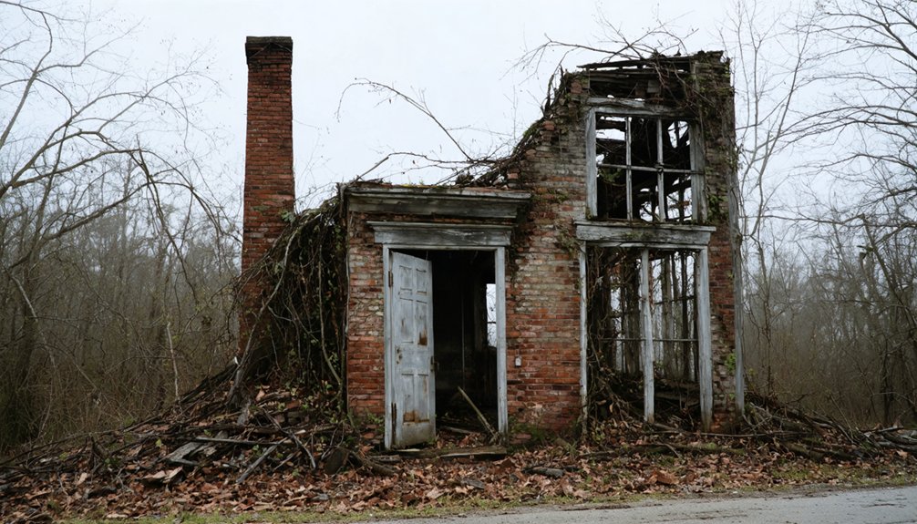
- Isham Kimbell, a prominent sheriff and merchant, demonstrated the community’s resilience by building his notable house in 1848.
- The settlement attracted diverse families engaged in farming, trade, and local governance.
- A thriving mercantile economy developed beyond basic subsistence farming.
- The town’s strategic location near major transportation routes fostered connections with neighboring communities.
You’ll find evidence of this transformation in the preserved Kimbell House, which stands as a symbol of the town’s evolution from frontier post to established community.
The Railroad’s Impact on Town Survival
During the late nineteenth century, railroad development transformed Choctaw Corner’s economic landscape, as major lines like the Mobile and West Alabama Railroad and the Alabama, Tennessee, and Northern Railroad established significant connections through the region.
The railroad’s significance became evident as it brought unprecedented opportunities for commerce and trade, connecting the town to larger markets and fostering economic growth.
You’ll find that the community’s resilience was tested when the railroad chose alternative routes.
While some neighboring towns like Thomasville flourished with direct rail access, Choctaw Corner faced the challenge of maintaining its economic dynamism without this essential transportation link.
The town’s fate ultimately hinged on its ability to adapt to changing transportation patterns, as rail connections became increasingly critical for survival in the evolving regional economy.
Historical Legacy and Physical Remnants

Today, the physical remnants of Choctaw Corner tell a compelling story of Native American territorial negotiations and early American settlement patterns.
You’ll find the cultural significance preserved through several key elements:
- The Choctaw Corner Cemetery on Thomasville’s western border stands as a symbol of the area’s rich heritage.
- A Clarke County Historical Marker commemorates the original boundary site where Choctaw and Creek territories met.
- The natural watershed between the Alabama and Tombigbee Rivers marks the historic territorial line.
- The original townsite, though absorbed by Thomasville, represents a pivotal chapter in local history.
Historical preservation efforts keep the memory alive of this unique place where Native Americans once settled land disputes through traditional ball games.
While the original structures are gone, the landscape itself continues to mark this significant crossroads of indigenous and settler history.
Frequently Asked Questions
What Native American Artifacts Have Been Found at Choctaw Corner?
You’ll discover projectile points, flake knives, stone tools, pottery fragments, and ground stone artifacts that reveal significant historical patterns through artifacts analysis spanning Paleo-Indian to Mississippian periods.
Are There Any Living Descendants of Original Choctaw Corner Settlers?
With over 180 years of settlement history, you won’t find confirmed descendant stories in public records – though family connections might exist among current Thomasville residents through untraced genealogical lines.
What Businesses Operated in Choctaw Corner During Its Peak?
You’d have found general stores, blacksmith shops, a post office, and merchant establishments in the historic buildings serving the local economy centered around cotton plantation supplies and trade services.
Does Anyone Still Maintain the Choctaw Corner Cemetery Today?
Yes, you’ll find the cemetery’s still actively maintained through local funeral homes, community volunteers, and preservation groups like the Alabama Cemetery Preservation Alliance, who support historical preservation and regular cemetery maintenance.
Were There Any Significant Civil War Events at Choctaw Corner?
Despite Alabama’s 89,000 Confederate soldiers, you won’t find any significant Civil War battles or military strategies at Choctaw Corner. Local troops joined larger campaigns elsewhere, leaving this site untouched by wartime conflict.
References
- https://digitalalabama.com/alabama-ghost-towns/alabama-ghost-towns/9449
- https://www.ruralswalabama.org/attraction/choctaw-corner-historical-marker-near-bashi-al/
- https://www.alabamahistory.net/copy-of-choctaw
- https://en.wikipedia.org/wiki/Choctaw_Corner
- https://theclio.com/entry/11697
- https://www.hmdb.org/m.asp?m=83271
- https://digitalalabama.com/alabama-historic-places-landmarks/historical-sites-in-clarke-county-alabama/21213
- https://encyclopediaofalabama.org/article/cahaba/
- https://www.clarkemuseum.com/html/markers.html
- http://leepeacock2010.blogspot.com/2022/04/old-indian-boundary-line-in-clarke.html